ATL: Tropical Depression Edouard
Moderator: S2k Moderators
-
fasterdisaster
- Category 5

- Posts: 1868
- Joined: Mon Sep 19, 2005 4:41 pm
- Location: Miami, Florida
-
Matt-hurricanewatcher
Re:
fasterdisaster wrote:Is there any reason this isn't a depression yet? Is there some conflicting wind obs?
No data has shown a closed LLC as of yet. I don't think it will be upgraded intil the recon gets into the system tomarrow anyways. Yes Miamiwx appears to see something developing but no data to confirm it to be all the way closed...
0 likes
Re: ATL: Invest 91L - Gulf of Mexico
Most of the buoys still have the wind coming out of the southwest, the Tampa buoy had wind out of the south but I could not find any wind out of the east at any buoys north of the convection *yet*?
0 likes
Wind Direction (WDIR): W ( 280 deg true )
Wind Speed (WSPD): 9.7 kts
Wind Gust (GST): 11.7 kts
Wave Height (WVHT): 2.3 ft
Dominant Wave Period (DPD): 5 sec
Average Period (APD): 3.8 sec
Atmospheric Pressure (PRES): 29.89 in
Pressure Tendency (PTDY): -0.03 in ( Falling )
Air Temperature (ATMP): 82.8 °F
Water Temperature (WTMP): 85.3 °F
Dew Point (DEWP): 77.2 °F
Heat Index (HEAT): 91.8 °F
Combined plot of Wind Speed, Gust, and Air Pressure
http://www.ndbc.noaa.gov/station_page.php?station=42040
Last edited by RL3AO on Sat Aug 02, 2008 6:22 pm, edited 1 time in total.
0 likes
Re: ATL: Invest 91L - Gulf of Mexico
Matt-hurricanewatcher wrote:fasterdisaster wrote:Is there any reason this isn't a depression yet? Is there some conflicting wind obs?
No data has shown a closed LLC as of yet. I don't think it will be upgraded intil the recon gets into the system tomarrow anyways. Yes Miamiwx appears to see something developing but no data to confirm it to be all the way closed...
Yes, we saw some lite easterly winds earlier along the western panhandle of Fla. but nothing lately
0 likes
- LSU2001
- S2K Supporter

- Posts: 1711
- Age: 58
- Joined: Sat Sep 11, 2004 11:01 pm
- Location: Cut Off, Louisiana
Re: ATL: Invest 91L - Gulf of Mexico
http://www.ndbc.noaa.gov/station_page.php?station=mcga1
The above bouy is in Mobile bay and is showing a N to NNE wind direction. Could this be the beginning of a wind shift for the invest??
TIm
The above bouy is in Mobile bay and is showing a N to NNE wind direction. Could this be the beginning of a wind shift for the invest??
TIm
0 likes
Re: ATL: Invest 91L - Gulf of Mexico
we will see what conditions we encounter during the flight and if we can get the cardinal winds....
as of right now the invest is still on.... CARCAH has til takeoff time to cancel if they deem necessary.
as of right now the invest is still on.... CARCAH has til takeoff time to cancel if they deem necessary.
0 likes
- vbhoutex
- Storm2k Executive

- Posts: 29151
- Age: 74
- Joined: Wed Oct 09, 2002 11:31 pm
- Location: Cypress, TX
- Contact:
Re: ATL: Invest 91L - Gulf of Mexico
http://www.wunderground.com/radar/radblast.asp?zoommode=zoom&num=6&delay=15&scale=1.000&noclutter=0&ID=MOB&type=N0Z&lat=0&lon=0&label=you&showstorms=0&map.x=463&map.y=228¢erx=400¢ery=240&lightning=0&smooth0&showlabels=1&rainsnow=0
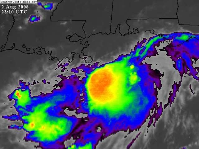
Take a look at the starts of storms directly S of the Buras area(the tip of SE LA). Am I imagining things or are they beginning to spin in a counterclockwise direction. They are barely even showing up as dots at this time. That is why I am doubting myself.
Good analysis Miamiensiswx. I think you could be right about the possible LLC startup. On visible the MLC is completly noticeable to the NE of the heavier convection. Given 24 hours or so for alignment to begin and we could quickly have something to watch even closer.
0 likes
Trof isn't moving anywhere any time soon. Ignore those complexes, because they will pulse and wane. I actually like the BAM tracks a little, but I would be willing to bet that besides a slow evolution, the movement will be too. That means should the storm get any better organized, the east side should see some rain if it's not too far offshore. JMO of course.
Steve
Steve
0 likes
- vbhoutex
- Storm2k Executive

- Posts: 29151
- Age: 74
- Joined: Wed Oct 09, 2002 11:31 pm
- Location: Cypress, TX
- Contact:
Re:
RL3AO wrote:Wind Direction (WDIR): W ( 280 deg true )
Wind Speed (WSPD): 9.7 kts
Wind Gust (GST): 11.7 kts
Wave Height (WVHT): 2.3 ft
Dominant Wave Period (DPD): 5 sec
Average Period (APD): 3.8 sec
Atmospheric Pressure (PRES): 29.89 in
Pressure Tendency (PTDY): -0.03 in ( Falling )
Air Temperature (ATMP): 82.8 °F
Water Temperature (WTMP): 85.3 °F
Dew Point (DEWP): 77.2 °F
Heat Index (HEAT): 91.8 °F
Combined plot of Wind Speed, Gust, and Air Pressure
Where is this? What do you think it indicates?
0 likes
- HouTXmetro
- Category 5

- Posts: 3949
- Joined: Sun Jun 13, 2004 6:00 pm
- Location: District of Columbia, USA
-
Ed Mahmoud
Re: ATL: Invest 91L - Gulf of Mexico
If this stays Tropical Storm intensity or below, and doesn't go too far North/East, East of about Cameron, LA, or too far South, Corpus Christi area, my lawn, and area farmers, welcome this.
I went to Austin for work last Wednesday, I-10 and Texas 71, crops are either dead or in deep trouble.
I went to Austin for work last Wednesday, I-10 and Texas 71, crops are either dead or in deep trouble.
0 likes
Re: ATL: Invest 91L - Gulf of Mexico
http://radar.weather.gov/radar.php?rid=MOB&product=N0Z&overlay=11101111&loop=yes
That is the only rotation I can pick out on radar....however radar that far out does not indicate a surface circulation. Winds have switched from to a more northerly component in Mobile Bay as well, indicating something might be starting to form. I will go out on a limb and say tom if recon finds a depression, we might need to SERIOUSLY watch this.
That is the only rotation I can pick out on radar....however radar that far out does not indicate a surface circulation. Winds have switched from to a more northerly component in Mobile Bay as well, indicating something might be starting to form. I will go out on a limb and say tom if recon finds a depression, we might need to SERIOUSLY watch this.
0 likes
- HouTXmetro
- Category 5

- Posts: 3949
- Joined: Sun Jun 13, 2004 6:00 pm
- Location: District of Columbia, USA
Re: ATL: Invest 91L - Gulf of Mexico
Normandy wrote:http://radar.weather.gov/radar.php?rid=MOB&product=N0Z&overlay=11101111&loop=yes
That is the only rotation I can pick out on radar....however radar that far out does not indicate a surface circulation. Winds have switched from to a more northerly component in Mobile Bay as well, indicating something might be starting to form. I will go out on a limb and say tom if recon finds a depression, we might need to SERIOUSLY watch this.
Were already seriously watching it
0 likes
Re: ATL: Invest 91L - Gulf of Mexico
vbhoutex wrote:http://www.wunderground.com/radar/radblast.asp?zoommode=zoom&num=6&delay=15&scale=1.000&noclutter=0&ID=MOB&type=N0Z&lat=0&lon=0&label=you&showstorms=0&map.x=463&map.y=228¢erx=400¢ery=240&lightning=0&smooth0&showlabels=1&rainsnow=0
Take a look at the starts of storms directly S of the Buras area(the tip of SE LA). Am I imagining things or are they beginning to spin in a counterclockwise direction. They are barely even showing up as dots at this time. That is why I am doubting myself.
Good analysis Miamiensiswx. I think you could be right about the possible LLC startup. On visible the MLC is completly noticeable to the NE of the heavier convection. Given 24 hours or so for alignment to begin and we could quickly have something to watch even closer.
I thought I noticed a spin this morning. (on a very zoomed out radar they showed on the news)
If it's there we should for sure be able to see it in the morning. Or maybe later tonight.
0 likes
Re: ATL: Invest 91L - Gulf of Mexico
Check out the ground clutter on this radar loop. Notice the little shower ssw of panama city. If I had to guess I'd say the Very weak LLC is just south of Pensacloa.
http://radar.weather.gov/radar.php?prod ... x&loop=yes
http://radar.weather.gov/radar.php?prod ... x&loop=yes
0 likes
-
Ed Mahmoud
Re: ATL: Invest 91L - Gulf of Mexico
South of New Orleans= maybe hint of a surface circulation, but I'm not betting the mortgage...
Station 42001 - MID GULF 180 nm South of Southwest Pass, LA

Edit for unintentional comma...
Station 42001 - MID GULF 180 nm South of Southwest Pass, LA
Edit for unintentional comma...
0 likes
Re: ATL: Invest 91L - Gulf of Mexico
Ed Mahmoud wrote:South of New Orleans= maybe hint of a surface circulation, but I'm, not betting the mortgage...
Station 42001 - MID GULF 180 nm South of Southwest Pass, LA
Lets see if some of the coastal observations start to change in the next few hours. Right now everything reamains southerly.
0 likes
Who is online
Users browsing this forum: No registered users and 85 guests


