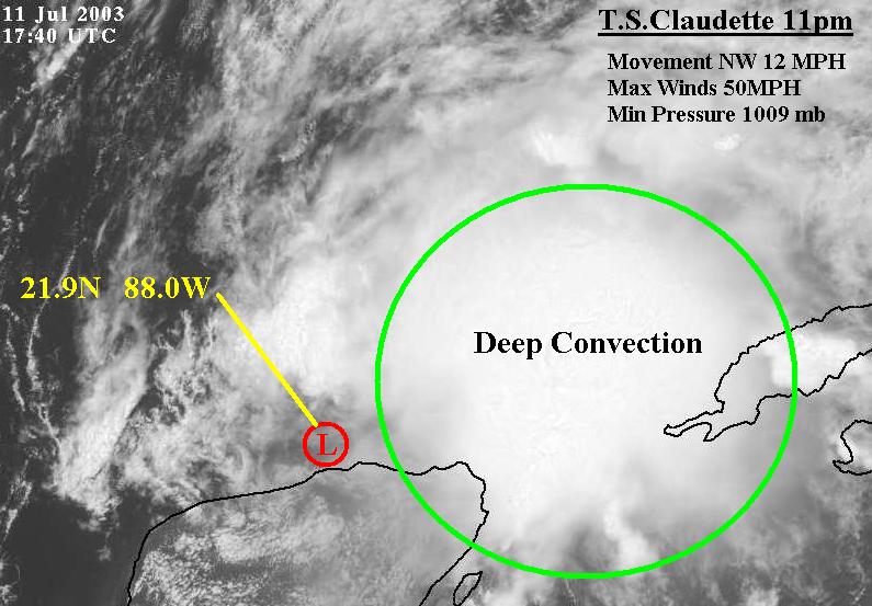
Tropical Storm Claudette Intermediate Advisory Number 12a
Statement as of 2:00 PM EDT on July 11, 2003
...Claudette slows a little and remains disorganized...
a Tropical Storm Warning remains in effect for the northern and
eastern coasts of the Yucatan Peninsula from progreso to Tulum.
Interests in western Cuba should continue to monitor the progress of
Claudette.
Satellite imagery and reports from an Air Force reserve hurricane
hunter aircraft indicate the center of Claudette is poorly-defined
and elongated from east-northeast to west-southwest.
At 2 PM EDT...1800z...the center of Tropical Storm Claudette was
located near latitude 21.9 north...longitude 88.0 west or about 95
miles... 150 km...northwest of Cancun Mexico.
Claudette is moving toward the northwest near 12 mph...19 km/hr...
and this general motion is expected to continue with a slower
forward speed during the next 24 hours. This motion should bring
the center into the southern Gulf of Mexico today.
Maximum sustained winds are near 50 mph... 90 km/hr...with higher
gusts. Little change in strength is forecast during the next
24 hours.
Tropical storm force winds extend outward up to 115 miles
...185 km from the center.
Estimated minimum central pressure is 1009 mb...29.80 inches.
Above normal tides will begin to subside today as Claudette moves
away from the Yucatan Peninsula.
Additional rainfall totals of 2 to 4 inches are likely in
association with Claudette.
Repeating the 2 PM EDT position...21.9 N... 88.0 W. Movement
toward...northwest near 12 mph. Maximum sustained
winds... 50 mph. Minimum central pressure...1009 mb.
For storm information specific to your area...please monitor
products issued by your local weather office.
The next advisory will be issued by the National Hurricane Center at
5 PM EDT.
Forecaster Beven
2PM Advisory
Moderator: S2k Moderators
Forum rules

The posts in this forum are NOT official forecasts and should not be used as such. They are just the opinion of the poster and may or may not be backed by sound meteorological data. They are NOT endorsed by any professional institution or STORM2K. For official information, please refer to products from the National Hurricane Center and National Weather Service.
-
southerngale

- Retired Staff

- Posts: 27418
- Joined: Thu Oct 10, 2002 1:27 am
- Location: Southeast Texas (Beaumont area)

 my Cowboys
 -
wx247

- S2K Supporter

- Posts: 14279
- Age: 42
- Joined: Wed Feb 05, 2003 10:35 pm
- Location: Monett, Missouri
- Contact:
That won't change (if it does at all) until the 4 pm CT advisory.
0 likes
Personal Forecast Disclaimer:
The posts in this forum are NOT official forecast and should not be used as such. They are just the opinion of the poster and may or may not be backed by sound meteorological data. They are NOT endorsed by any professional institution or storm2k.org. For official information, please refer to the NHC and NWS products.
The posts in this forum are NOT official forecast and should not be used as such. They are just the opinion of the poster and may or may not be backed by sound meteorological data. They are NOT endorsed by any professional institution or storm2k.org. For official information, please refer to the NHC and NWS products.
-
cycloneye

- Admin

- Posts: 149735
- Age: 69
- Joined: Thu Oct 10, 2002 10:54 am
- Location: San Juan, Puerto Rico
Kelly the NHC has been very consistent with that area for a landfall at the Texas/Mexico border and they will continue to add to that consistency keeping the track that way maybe shifting a tad to the right but not too much.
0 likes
Visit the Caribbean-Central America Weather Thread where you can find at first post web cams,radars
and observations from Caribbean basin members Click Here
and observations from Caribbean basin members Click Here

-
Air Force Met
- Military Met

- Posts: 4372
- Age: 57
- Joined: Tue Jul 08, 2003 9:30 am
- Location: Roan Mountain, TN
-
cycloneye
- Admin
- Posts: 149735
- Age: 69
- Joined: Thu Oct 10, 2002 10:54 am
- Location: San Juan, Puerto Rico
Oh boy seadootoo I said this morning in my post about landfall as I went out of the limb near CC.
0 likes
Visit the Caribbean-Central America Weather Thread where you can find at first post web cams,radars
and observations from Caribbean basin members Click Here
and observations from Caribbean basin members Click Here
-
chadtm80
-
Air Force Met
- Military Met
- Posts: 4372
- Age: 57
- Joined: Tue Jul 08, 2003 9:30 am
- Location: Roan Mountain, TN
-
ColdFront77
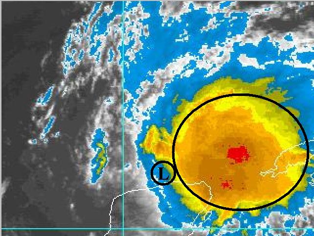
There must be a surface low trying to form under the deep convection to the east of the current low position.
I was looking at the coordinates and satellite imagery noticing the impressive convection to the east of the center. There is so much convection pressure could easily fall under that area.
I was looking at the coordinates and satellite imagery noticing the impressive convection to the east of the center. There is so much convection pressure could easily fall under that area.
0 likes

Who is online
Users browsing this forum: No registered users and 153 guests