Ex Invest 99L in Western Atlantic

Moderator: S2k Moderators

Message
Author
Mecklenburg

Re: ATL: Invest 98L - 8 AM TWO: TD may form later today

#121 Postby Mecklenburg » Wed Jul 30, 2008 7:04 am

grrrr.... the SAL is such a nuisance... why do this waves form at such higher latitudes than before?.. this season is getting to be boring...
0 likes   

User avatar
KWT
Category 5
Category 5
Posts: 31415
Joined: Tue Aug 17, 2004 11:02 am
Location: UK!!!

#122 Postby KWT » Wed Jul 30, 2008 7:07 am

Probably becuase they are forming so well overland they are gaining latitude before they even leave land and so come off at higher latitudes...reminds me of 1989 actually in that reagrds at least for the first CV systems.
0 likes   

Mecklenburg

Re: ATL: Invest 98L - 8 AM TWO: TD may form later today

#123 Postby Mecklenburg » Wed Jul 30, 2008 7:09 am

hmmm... in the long-range models thread.... a more rigorous storm may form behind this invest later this week... if this thing develops into Edouard, will this interrupt the development of the next system?
0 likes   

User avatar
caribepr
Category 5
Category 5
Posts: 1794
Joined: Fri Sep 05, 2003 10:43 pm
Location: Culebra, PR 18.33 65.33

#124 Postby caribepr » Wed Jul 30, 2008 7:10 am

Recurve might turn out to be my own personal favorite weather word this season...
0 likes   

User avatar
KWT
Category 5
Category 5
Posts: 31415
Joined: Tue Aug 17, 2004 11:02 am
Location: UK!!!

#125 Postby KWT » Wed Jul 30, 2008 7:11 am

This is probably one of the most obvious recurvers we will see all season given its already heading WNW/NW and its still east of the CV islands. Thats of course if the NHC upgrade it of course!
0 likes   

User avatar
HURAKAN
Professional-Met
Professional-Met
Posts: 46086
Age: 38
Joined: Thu May 20, 2004 4:34 pm
Location: Key West, FL
Contact:

#126 Postby HURAKAN » Wed Jul 30, 2008 7:16 am

AL, 98, 2008073006, , BEST, 0, 146N, 189W, 20, 1007, DB,

The 2008073000 pressure was increased to 1008 from 1006 mb.
0 likes   

User avatar
Gustywind
Category 5
Category 5
Posts: 12334
Joined: Mon Sep 03, 2007 7:29 am
Location: Baie-Mahault, GUADELOUPE

Re: ATL: Invest 98L - 8 AM TWO: TD may form later today

#127 Postby Gustywind » Wed Jul 30, 2008 7:16 am

Mecklenburg wrote:grrrr.... the SAL is such a nuisance... why do this waves form at such higher latitudes than before?.. this season is getting to be boring...

Are you falling in a Warner Bros with the big lady???... we're only in July with this strong activity :x stay calm we 're far away from the end, keep you energy on August and especially September. To sump up, take it easy and do not let your guard down , tropics are always versalite things can turn quickly....We should continue to see what happens with this in spite of assuming that it's a fish or not it's only an early stage of developpement as TD status given the sat pic appearence and the latest TWO and TWD. For my part if this has not pass the 20°N and the 60W it's always a thread for the Lesser Antilles!
0 likes   

User avatar
wxman57
Moderator-Pro Met
Moderator-Pro Met
Posts: 22978
Age: 67
Joined: Sat Jun 21, 2003 8:06 pm
Location: Houston, TX (southwest)

Re: ATL: Invest 98L - 8 AM TWO: TD may form later today

#128 Postby wxman57 » Wed Jul 30, 2008 7:17 am

Mecklenburg wrote:grrrr.... the SAL is such a nuisance... why do this waves form at such higher latitudes than before?.. this season is getting to be boring...


Read Dr. Klotzbach's outlook with respect to the Atlantic Meridional Mode (AMM) on pages 16-17 of his April forecast:

http://hurricane.atmos.colostate.edu/Fo ... pr2008.pdf

The predictors indicate a weaker-than-normal Bermuda high this year. This could allow for may systems to recurve east of the Caribbean.
Last edited by wxman57 on Wed Jul 30, 2008 7:19 am, edited 1 time in total.
0 likes   

User avatar
Gustywind
Category 5
Category 5
Posts: 12334
Joined: Mon Sep 03, 2007 7:29 am
Location: Baie-Mahault, GUADELOUPE

Re:

#129 Postby Gustywind » Wed Jul 30, 2008 7:18 am

caribepr wrote:Recurve might turn out to be my own personal favorite weather word this season...

Me too, with some rains to erase the drought sometimes, that's ok :D
0 likes   

User avatar
wxman57
Moderator-Pro Met
Moderator-Pro Met
Posts: 22978
Age: 67
Joined: Sat Jun 21, 2003 8:06 pm
Location: Houston, TX (southwest)

Re: ATL: Invest 98L - 8 AM TWO: TD may form later today

#130 Postby wxman57 » Wed Jul 30, 2008 7:20 am

06Z model data is out, but the LLC is well northwest of that position now. Clearly west of 20W and north of 15N.
0 likes   

User avatar
HURAKAN
Professional-Met
Professional-Met
Posts: 46086
Age: 38
Joined: Thu May 20, 2004 4:34 pm
Location: Key West, FL
Contact:

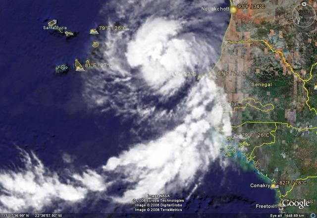
#131 Postby HURAKAN » Wed Jul 30, 2008 7:28 am

Image

How much organized has it to be to be declared a TD?

LLC. check
Organized convection. check
0 likes   

User avatar
bvigal
S2K Supporter
S2K Supporter
Posts: 2276
Joined: Sun Jul 24, 2005 8:49 am
Location: British Virgin Islands
Contact:

Re: ATL: Invest 98L - 8 AM TWO: TD may form later today

#132 Postby bvigal » Wed Jul 30, 2008 7:28 am

wxman57 wrote:Read Dr. Klotzbach's outlook with respect to the Atlantic Meridional Mode (AMM) on pages 16-17 of his April forecast:

http://hurricane.atmos.colostate.edu/Fo ... pr2008.pdf

The predictors indicate a weaker-than-normal Bermuda high this year. This could allow for may systems to recurve east of the Caribbean.
Fine with me!

wxman57 wrote:Good chance it may be upgraded then dissipate in a day or two. Once past the Cape Verde Islands it's about 99.99999% chance a fish storm.
Hey you guys, listen to wxman57, he's pointing out some good common sense factors. Without a strong ridge, how can anything already AT LEAST 14.6N, and east of Cape Verdes, cross the entire Atlantic ocean? Any climatology for this?
0 likes   

User avatar
HURAKAN
Professional-Met
Professional-Met
Posts: 46086
Age: 38
Joined: Thu May 20, 2004 4:34 pm
Location: Key West, FL
Contact:

#133 Postby HURAKAN » Wed Jul 30, 2008 7:31 am

:uarrow: Only a strong ridge of high pressure extending between the Bermuda and Azores high would do that.
0 likes   

User avatar
KWT
Category 5
Category 5
Posts: 31415
Joined: Tue Aug 17, 2004 11:02 am
Location: UK!!!

#134 Postby KWT » Wed Jul 30, 2008 7:31 am

There's been a few in the past that far north that have made it but to be honest its not going to happen with 98L. Interesting to hear about the Bermuda high does seem to be fairly weak this year thus far though of course systems can slip under the net, look at Dolly for an example of that...
0 likes   

User avatar
bvigal
S2K Supporter
S2K Supporter
Posts: 2276
Joined: Sun Jul 24, 2005 8:49 am
Location: British Virgin Islands
Contact:

Re:

#135 Postby bvigal » Wed Jul 30, 2008 7:34 am

KWT wrote:There's been a few in the past that far north that have made it but to be honest its not going to happen with 98L. Interesting to hear about the Bermuda high does seem to be fairly weak this year thus far though of course systems can slip under the net, look at Dolly for an example of that...

Yes, but those few... wasn't there a strong ridge that steered them west?
0 likes   

User avatar
HURAKAN
Professional-Met
Professional-Met
Posts: 46086
Age: 38
Joined: Thu May 20, 2004 4:34 pm
Location: Key West, FL
Contact:

#136 Postby HURAKAN » Wed Jul 30, 2008 7:34 am

AL, 98, 2008073012, , BEST, 0, 154N, 199W, 25, 1008, DB,
0 likes   

User avatar
Chacor
Category 5
Category 5
Posts: 10229
Joined: Mon Oct 02, 2006 10:43 pm
Location: Singapore

#137 Postby Chacor » Wed Jul 30, 2008 7:37 am

SHIPS shear forecast is not favourable in the long-term.

Code: Select all

TIME (HR)          0     6    12    18    24    36    48    60    72    84    96   108   120
SHEAR (KTS)        8    11    14    15    16    18    15    23    26    27    24    20    14
0 likes   

User avatar
KWT
Category 5
Category 5
Posts: 31415
Joined: Tue Aug 17, 2004 11:02 am
Location: UK!!!

#138 Postby KWT » Wed Jul 30, 2008 7:37 am

bvigal, yep indeed and in this case there obviously isn't that factor in play, indeed even if it did bend back west it would still recurve probably around 50-60W...but from the looks of things this will probably head NW for a little while yet into the colder waters.
0 likes   

User avatar
HURAKAN
Professional-Met
Professional-Met
Posts: 46086
Age: 38
Joined: Thu May 20, 2004 4:34 pm
Location: Key West, FL
Contact:

#139 Postby HURAKAN » Wed Jul 30, 2008 7:39 am

Image
0 likes   

User avatar
HURAKAN
Professional-Met
Professional-Met
Posts: 46086
Age: 38
Joined: Thu May 20, 2004 4:34 pm
Location: Key West, FL
Contact:

Re:

#140 Postby HURAKAN » Wed Jul 30, 2008 7:40 am

Chacor wrote:SHIPS shear forecast is not favourable in the long-term.

Code: Select all

TIME (HR)          0     6    12    18    24    36    48    60    72    84    96   108   120
SHEAR (KTS)        8    11    14    15    16    18    15    23    26    27    24    20    14


I don't doubt it but the other day it was showing 97L in almost no shear when the invest was being decapitated.
0 likes   


Return to “2008”

Who is online

Users browsing this forum: No registered users and 6 guests