

"Although it weakened prior to making landfall as a Category 3 hurricane near the Texas/Louisiana border, Rita produced significant storm surge that devastated coastal communities in southwestern Louisiana, and its winds, rain, and tornadoes caused fatalities and a wide swath of damage from eastern Texas to Alabama."
"landfall between Johnson’s Bayou, LA and Sabine Pass, TX."
Link: http://www.nhc.noaa.gov/pdf/TCR-AL182005_Rita.pdf
That's why I considered Rita a Texas landfall.
ATL: Tropical Depression Dolly
Moderator: S2k Moderators
-
Wx_Warrior
- Category 5

- Posts: 2718
- Joined: Thu Aug 03, 2006 3:58 pm
- Location: Beaumont, TX
Re: ATL: H Dolly in Western Gulf of Mexico
There you have it...Believe me. I was here when she landed. We had reporters in Sabine Pass and that pointed their cameras up into the sky taking photos when some of the eye was passing over.
0 likes
-
HarlequinBoy

- Category 5
- Posts: 1400
- Age: 35
- Joined: Wed Nov 29, 2006 1:57 am
- Location: Memphis

>>Rita accounts some say Sabine Pass (TX) others claim Johnson Bayou (La).
Forget what they say. Look at the eye coming in:
http://billday.com/Images/Blogged/Hurri ... l.anim.gif
National coverage was a joke in that all they focused on was Galveston and Houston and forgot everything else up the coast of Texas toward Lake Charles. It was one time the media got stung by their own sensationalism. I was watching it from Dauphin Island and someone with a sat phone on CNN was the first person to report from Lake Charles and Sulphur where the early damage was until Rita demolished lots of the the border area between LA/TX.
Steve
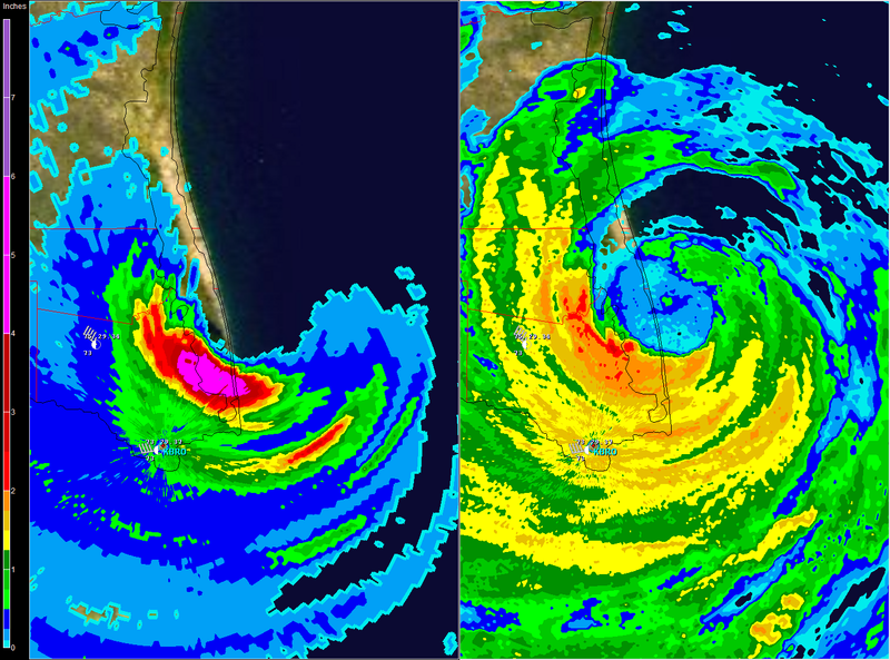
PS - here's the radar shot:
http://upload.wikimedia.org/wikipedia/c ... _radar.gif
It doesn't really matter, but still...
Forget what they say. Look at the eye coming in:
http://billday.com/Images/Blogged/Hurri ... l.anim.gif
National coverage was a joke in that all they focused on was Galveston and Houston and forgot everything else up the coast of Texas toward Lake Charles. It was one time the media got stung by their own sensationalism. I was watching it from Dauphin Island and someone with a sat phone on CNN was the first person to report from Lake Charles and Sulphur where the early damage was until Rita demolished lots of the the border area between LA/TX.
Steve
PS - here's the radar shot:
http://upload.wikimedia.org/wikipedia/c ... _radar.gif
It doesn't really matter, but still...
Last edited by Steve on Wed Jul 23, 2008 1:12 pm, edited 1 time in total.
0 likes

Re: ATL: H Dolly in Western Gulf of Mexico
Port Mansfield is going getting spanked right now.
0 likes
-
Brent
- S2K Supporter

- Posts: 38729
- Age: 37
- Joined: Sun May 16, 2004 10:30 pm
- Location: Tulsa Oklahoma
- Contact:
Re: ATL: H Dolly in Western Gulf of Mexico
CrazyC83 wrote:Enzo Aquarius wrote:From Wikipedia:Rita made landfall on September 24 between Sabine Pass, Texas and Johnsons Bayou, Louisiana, as a Category 3 hurricane on the Saffir-Simpson Hurricane Scale.
I think it was right over the river that formed the boundary. The strongest winds would have been in Louisiana though.
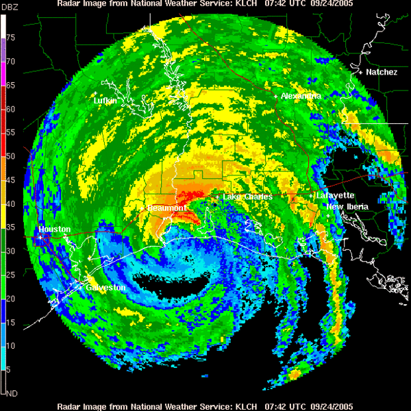
REPORTS FROM AIR FORCE RESERVE HURRICANE HUNTER AIRCRAFT AND
NATIONAL WEATHER SERVICE WSR-88D RADARS INDICATE THAT RITA MADE
LANDFALL JUST EAST OF SABINE PASS ABOUT 0730Z
Technically LA but I consider it both.
Anyway, back to Dolly, she sure is taking her sweet time.
Last edited by Brent on Wed Jul 23, 2008 1:16 pm, edited 1 time in total.
0 likes

>>CNN: Rio Grande should hold up. No reports of injuries or major flooding yet.
Flash Flood Warning out for Brownsville as the eye creeps in ever so slowly. This is going to be a nasty bunch of hours ahead. FWIW, the left front quadrant (SW part of the storm in this case) appears to be the worst part of the storm based on radar and enhanced IR:
http://radar.weather.gov/radar.php?rid= ... 1&loop=yes
Steve
0 likes
-
Enzo Aquarius
- Tropical Storm

- Posts: 160
- Joined: Wed Jul 23, 2008 12:53 pm
- Location: Canada
Re: ATL: H Dolly in Western Gulf of Mexico
None of the river gauges in the area, as listed by the NWS, are in flood stages yet.
Tornado warning north of Corpus Christi has been lifted.
Tornado warning north of Corpus Christi has been lifted.
0 likes

Re: ATL: H Dolly in Western Gulf of Mexico
It's also worth remembering that the reports you hear first in the media are often the places that didn't get hit quite so badly, sometimes leading to the false impression (like with Rita) that the storm wasn't so bad. It's the places that *did* get hit, who don't have power or cell, that can't report in right away.
0 likes
-
CajunMama
- Retired Staff

- Posts: 10791
- Joined: Thu Feb 06, 2003 9:57 pm
- Location: 30.22N, 92.05W Lafayette, LA
Re: ATL: H Dolly in Western Gulf of Mexico

Let's stick to dolly and not debate where rita made landfall
0 likes
Re: ATL: H Dolly in Western Gulf of Mexico
Enzo Aquarius wrote:None of the river gauges in the area, as listed by the NWS, are in flood stages yet.
Tornado warning north of Corpus Christi has been lifted.
Is there an online link to these gauges?
0 likes
-
Enzo Aquarius
- Tropical Storm
- Posts: 160
- Joined: Wed Jul 23, 2008 12:53 pm
- Location: Canada
Re: ATL: H Dolly in Western Gulf of Mexico
kurtpage wrote:Enzo Aquarius wrote:None of the river gauges in the area, as listed by the NWS, are in flood stages yet.
Tornado warning north of Corpus Christi has been lifted.
Is there an online link to these gauges?
http://ahps.srh.noaa.gov/ahps2/index.php?wfo=bro
Too bad there aren't a lot of gauges in the area.
0 likes
Re: ATL: H Dolly in Western Gulf of Mexico
Enzo Aquarius wrote:kurtpage wrote:Enzo Aquarius wrote:None of the river gauges in the area, as listed by the NWS, are in flood stages yet.
Tornado warning north of Corpus Christi has been lifted.
Is there an online link to these gauges?
http://ahps.srh.noaa.gov/ahps2/index.php?wfo=bro
Too bad there aren't a lot of gauges in the area.
Thank you very much!
0 likes


Re: Re:
Category 5 wrote:HURAKAN wrote:Strongest hurricane to hit Texas since Rita, I believe, and the strongest since Bret, 1999.
No Rita was much stronger.
South Texas yes but not all of Texas.
Just best to read "since Rita" and end there
Thus far, the hurricane is about what I expected it would be. It appears that Port Isabel was a good choice for chasing it for those doing so.
0 likes
-
Enzo Aquarius
- Tropical Storm
- Posts: 160
- Joined: Wed Jul 23, 2008 12:53 pm
- Location: Canada
Re: ATL: H Dolly in Western Gulf of Mexico
Nonetheless, the gauge at Brownsville is showing a quick increase in water levels. It's at 7.87 feet, flood stage is 27 feet.
http://ahps.srh.noaa.gov/ahps2/hydrogra ... ,1,1,1,1,1
http://ahps.srh.noaa.gov/ahps2/hydrogra ... ,1,1,1,1,1
0 likes


Re: ATL: H Dolly in Western Gulf of Mexico
Just got a message from my cousin, they are holding the backdoor...
man..
man..
0 likes

Re: ATL: H Dolly in Western Gulf of Mexico
SPI taking a bad hit according to NWS BRO.
http://www.srh.noaa.gov/bro/news/2008/dolly_news_update.htm
http://www.srh.noaa.gov/bro/news/2008/dolly_news_update.htm
0 likes
Who is online
Users browsing this forum: No registered users and 25 guests