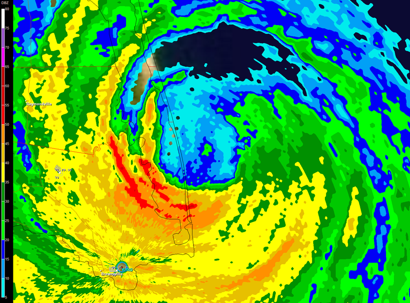
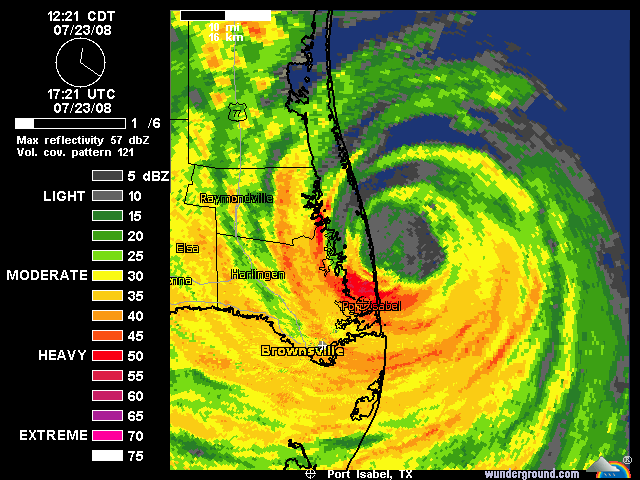
ATL: Tropical Depression Dolly

Moderator: S2k Moderators

Message
Author
JPmia
S2K Supporter
S2K Supporter
Posts: 1070
Joined: Thu Jun 03, 2004 11:01 pm
Location: Fort Lauderdale, FL

Re: Re:

#7981 Postby JPmia » Wed Jul 23, 2008 12:52 pm

dizzyfish wrote:
KWT wrote:Wow lester88, that SW eyewall is really intense right now some pretty explosive convection at the moment.


Is SPI under that convection or are they further north?


According to Google Earth that is SPI (South Padre Island)
0 likes   

User avatar
HURAKAN
Professional-Met
Professional-Met
Posts: 46086
Age: 38
Joined: Thu May 20, 2004 4:34 pm
Location: Key West, FL
Contact:

#7982 Postby HURAKAN » Wed Jul 23, 2008 12:52 pm

Strongest hurricane to hit Texas since Rita, I believe, and the strongest since Bret, 1999.
0 likes   

User avatar
Category 5
Category 5
Category 5
Posts: 10074
Age: 35
Joined: Sun Feb 11, 2007 10:00 pm
Location: New Brunswick, NJ
Contact:

Re: ATL: H Dolly in Western Gulf of Mexico

#7983 Postby Category 5 » Wed Jul 23, 2008 12:54 pm

Landfall occuring. Looks like 1pm CDT will be the landfall time.

Image
0 likes   

User avatar
funster
Category 3
Category 3
Posts: 816
Joined: Sat Dec 29, 2007 4:27 pm
Location: North Dallas

Re:

#7984 Postby funster » Wed Jul 23, 2008 12:54 pm

HURAKAN wrote:Strongest hurricane to hit Texas since Rita, I believe, and the strongest since Bret, 1999.


How strong was Humberto?
0 likes   

User avatar
KWT
Category 5
Category 5
Posts: 31415
Joined: Tue Aug 17, 2004 11:02 am
Location: UK!!!

#7985 Postby KWT » Wed Jul 23, 2008 12:54 pm

Yep also strongest hurricane to hit the states since Wilma back in 2005. Very impressive system, has it made offical landfall yet :?:
0 likes   

User avatar
HarlequinBoy
Category 5
Category 5
Posts: 1400
Age: 34
Joined: Wed Nov 29, 2006 1:57 am
Location: Memphis

Re: Re:

#7986 Postby HarlequinBoy » Wed Jul 23, 2008 12:54 pm

funster wrote:
HURAKAN wrote:Strongest hurricane to hit Texas since Rita, I believe, and the strongest since Bret, 1999.


How strong was Humberto?


90 mph.
0 likes   

Wx_Warrior
Category 5
Category 5
Posts: 2718
Joined: Thu Aug 03, 2006 3:58 pm
Location: Beaumont, TX

Re: ATL: H Dolly in Western Gulf of Mexico

#7987 Postby Wx_Warrior » Wed Jul 23, 2008 12:55 pm

Storming in Beaumont
0 likes   

User avatar
Category 5
Category 5
Category 5
Posts: 10074
Age: 35
Joined: Sun Feb 11, 2007 10:00 pm
Location: New Brunswick, NJ
Contact:

Re:

#7988 Postby Category 5 » Wed Jul 23, 2008 12:55 pm

HURAKAN wrote:Strongest hurricane to hit Texas since Rita, I believe, and the strongest since Bret, 1999.


No Rita was much stronger.

South Texas yes but not all of Texas.
0 likes   

User avatar
HURAKAN
Professional-Met
Professional-Met
Posts: 46086
Age: 38
Joined: Thu May 20, 2004 4:34 pm
Location: Key West, FL
Contact:

Re:

#7989 Postby HURAKAN » Wed Jul 23, 2008 12:56 pm

HURAKAN wrote:Strongest hurricane to hit Texas since Rita, I believe, and the strongest since Bret, 1999.


Correction: Strongest to hit South Texas since Bret in 1999.
0 likes   

RL3AO
Moderator-Pro Met
Moderator-Pro Met
Posts: 16308
Joined: Thu Jun 14, 2007 10:03 pm
Location: NC

#7990 Postby RL3AO » Wed Jul 23, 2008 12:56 pm

Image


About 4 nmi from Padre Island.
0 likes   

RL3AO
Moderator-Pro Met
Moderator-Pro Met
Posts: 16308
Joined: Thu Jun 14, 2007 10:03 pm
Location: NC

Re: ATL: H Dolly in Western Gulf of Mexico

#7991 Postby RL3AO » Wed Jul 23, 2008 12:59 pm

000
UZNT13 KNHC 231753
XXAA 73187 99262 70971 08267 99978 23803 23078 00693 ///// /////
92491 21802 25085 85226 19401 25061 70888 13000 25042 88999 77999
31313 09608 81732
61616 AF302 1904A DOLLY OB 41
62626 EYEWALL 180 SPL 2620N09702W 1734 MBL WND 24587 AEV 00000 DL
M WND 25081 978820 WL150 23587 080 =
XXBB 73188 99262 70971 08267 00978 23803 11850 19401 22808 19000
33698 13000
21212 00978 23078 11964 24092 22914 25081 33903 25588 44896 26081
55877 25574 66867 26065 77850 25061 88698 25042
31313 09608 81732
61616 AF302 1904A DOLLY OB 41
62626 EYEWALL 180 SPL 2620N09702W 1734 MBL WND 24587 AEV 00000 DL
M WND 25081 978820 WL150 23587 080 =
;

78kt at surface with 92kt just above the surface.
0 likes   

User avatar
HarlequinBoy
Category 5
Category 5
Posts: 1400
Age: 34
Joined: Wed Nov 29, 2006 1:57 am
Location: Memphis

#7992 Postby HarlequinBoy » Wed Jul 23, 2008 12:59 pm

THE NATIONAL WEATHER SERVICE IN BROWNSVILLE HAS ISSUED A

* FLASH FLOOD WARNING FOR...
EASTERN CAMERON COUNTY IN DEEP SOUTH TEXAS.

LOCATIONS AFFECTED INCLUDE...
PORT ISABEL.


* UNTIL 345 PM CDT

* AT 1250 PM CDT...NATIONAL WEATHER SERVICE DOPPLER RADAR
INDICATED FLASH FLOODING FROM RAINFALL OF FIVE INCHES PER HOUR
FROM A LARGE SQUALL OF SHOWERS AND THUNDERSTORMS FROM 16 MILES
NORTHWEST OF PORT ISABEL TO PORT ISABEL...MOVING WEST AT 8 MPH.

* SQUALLS WITH TORRENTIAL RAIN WILL BE NEAR...
HOLLY BEACH.
SOUTH PADRE ISLAND.
LAGUNA VISTA.
LAGUNA HEIGHTS.

WIDESPREAD FLOODING IS OCCURRING...OR WILL OCCUR...IN THE WARNED
AREA. NUMEROUS ROADS WILL BE CLOSED...AND HOMES...ESPECIALLY IN LOW
LYING AREAS...WILL BECOME INUNDATED. MOVE TO HIGHER GROUND
IMMEDIATELY!

Geez!
0 likes   

User avatar
Enzo Aquarius
Tropical Storm
Tropical Storm
Posts: 160
Joined: Wed Jul 23, 2008 12:53 pm
Location: Canada

Re: ATL: H Dolly in Western Gulf of Mexico

#7993 Postby Enzo Aquarius » Wed Jul 23, 2008 1:00 pm

TORNADO WARNING
TXC409-231815-
/O.NEW.KCRP.TO.W.0016.080723T1745Z-080723T1815Z/

BULLETIN - EAS ACTIVATION REQUESTED
TORNADO WARNING
NATIONAL WEATHER SERVICE CORPUS CHRISTI TX
1245 PM CDT WED JUL 23 2008

THE NATIONAL WEATHER SERVICE IN CORPUS CHRISTI HAS ISSUED A

* TORNADO WARNING FOR...
EAST CENTRAL SAN PATRICIO COUNTY IN SOUTH TEXAS

* UNTIL 115 PM CDT

* AT 1240 PM CDT...NATIONAL WEATHER SERVICE DOPPLER RADAR INDICATED A
SEVERE THUNDERSTORM CAPABLE OF PRODUCING A TORNADO 7 MILES
NORTHEAST OF GREGORY...OR ABOUT 10 MILES EAST OF TAFT...MOVING
TO TH WEST-SOUTHWEST AT 24 MPH.

* THE TORNADO WILL BE NEAR...
TAFT BY 105 PM CDT...

WHEN A TORNADO WARNING IS ISSUED BASED ON DOPPLER RADAR...IT MEANS
THAT STRONG ROTATION HAS BEEN DETECTED IN THE STORM. A TORNADO MAY
ALREADY BE ON THE GROUND...OR IS EXPECTED TO DEVELOP SHORTLY. IF YOU
ARE IN THE PATH OF THIS DANGEROUS STORM...MOVE INDOORS AND TO THE
LOWEST LEVEL OF THE BUILDING. STAY AWAY FROM WINDOWS. IF DRIVING...DO
NOT SEEK SHELTER UNDER A HIGHWAY OVERPASS.

A TORNADO WATCH REMAINS IN EFFECT UNTIL 700 PM CDT WEDNESDAY EVENING
FOR SOUTH TEXAS.

LAT...LON 2804 9751 2806 9725 2805 9724 2804 9724
2802 9722 2795 9717 2794 9717 2787 9743
TIME...MOT...LOC 1745Z 073DEG 21KT 2801 9726

$$

TMT
0 likes   

User avatar
Tampa Bay Hurricane
Category 5
Category 5
Posts: 5597
Age: 37
Joined: Fri Jul 22, 2005 7:54 pm
Location: St. Petersburg, FL

#7994 Postby Tampa Bay Hurricane » Wed Jul 23, 2008 1:00 pm

Weather Channel's Jim Cantore on South Padre Island just
reported very intense winds with debris.

I would guess category 2 conditions is occuring there.
0 likes   

User avatar
Thunder44
Category 5
Category 5
Posts: 5922
Age: 44
Joined: Mon Jun 09, 2003 7:53 pm
Location: New York City

Re: ATL: H Dolly in Western Gulf of Mexico

#7995 Postby Thunder44 » Wed Jul 23, 2008 1:03 pm

ZCZC MIATCEAT4 ALL
TTAA00 KNHC DDHHMM
HURRICANE DOLLY TROPICAL CYCLONE POSITION ESTIMATE
NWS TPC/NATIONAL HURRICANE CENTER MIAMI FL AL042008
100 PM CDT WED JUL 23 2008

AT 1 PM CDT THE EYE OF HURRICANE DOLLY WAS ESTIMATED NEAR
LATITUDE 26.3 NORTH...LONGITUDE 97.2 WEST...MAKING LANDFALL ON SOUTH
PADRE ISLAND...ABOUT 35 MILES...60 KM...NORTHEAST OF BROWNSVILLE
TEXAS OR 40 MILES...65 KM...EAST-SOUTHEAST OF RAYMONDVILLE.

$$
FORECASTER AVILA

NNNN
0 likes   

User avatar
Steve
S2K Supporter
S2K Supporter
Posts: 9621
Joined: Sat Apr 05, 2003 11:41 pm
Location: Not a state-caster

#7996 Postby Steve » Wed Jul 23, 2008 1:03 pm

>>Strongest hurricane to hit Texas since Rita

Rita didn't hit Texas, it hit Cameron Parish. It damaged East Texas a ways up though. Lots of moisture here, as it's been raining since 10:00. Lots more to come in SE/SC/SW LA and SE and S TX.

Steve

PS - 967mb goes to show what they talk about with Texas storms making landfall nearly perpendicularly to the coast and intensification at landfall having to do with land interaction of the spin. For anyone who doesn't have this committed to memory, you've now seen it first hand.

Steve
Last edited by Steve on Wed Jul 23, 2008 1:04 pm, edited 1 time in total.
0 likes   

User avatar
KWT
Category 5
Category 5
Posts: 31415
Joined: Tue Aug 17, 2004 11:02 am
Location: UK!!!

#7997 Postby KWT » Wed Jul 23, 2008 1:03 pm

Yep RL3AO 78kts is probably ot far off from SPI sadly, I'm not at all surprised Jim is reporting what he has given the sort of winds that are still about, 78kts is still able to justify 80kts, a powerful category-1.

Yep Dolly has offically made landfall!
0 likes   

User avatar
Category 5
Category 5
Category 5
Posts: 10074
Age: 35
Joined: Sun Feb 11, 2007 10:00 pm
Location: New Brunswick, NJ
Contact:

Re: ATL: H Dolly in Western Gulf of Mexico

#7998 Postby Category 5 » Wed Jul 23, 2008 1:06 pm

Cantore is saying that it may be the worst hit to Padre island since Beulah in 1967.
0 likes   

User avatar
Enzo Aquarius
Tropical Storm
Tropical Storm
Posts: 160
Joined: Wed Jul 23, 2008 12:53 pm
Location: Canada

Re: ATL: H Dolly in Western Gulf of Mexico

#7999 Postby Enzo Aquarius » Wed Jul 23, 2008 1:06 pm

From Wikipedia:

Rita made landfall on September 24 between Sabine Pass, Texas and Johnsons Bayou, Louisiana, as a Category 3 hurricane on the Saffir-Simpson Hurricane Scale.
0 likes   

CrazyC83
Professional-Met
Professional-Met
Posts: 34002
Joined: Tue Mar 07, 2006 11:57 pm
Location: Deep South, for the first time!

Re: ATL: H Dolly in Western Gulf of Mexico

#8000 Postby CrazyC83 » Wed Jul 23, 2008 1:07 pm

Enzo Aquarius wrote:From Wikipedia:

Rita made landfall on September 24 between Sabine Pass, Texas and Johnsons Bayou, Louisiana, as a Category 3 hurricane on the Saffir-Simpson Hurricane Scale.


I think it was right over the river that formed the boundary. The strongest winds would have been in Louisiana though.
0 likes   


Return to “2008”

Who is online

Users browsing this forum: No registered users and 6 guests