ATL: Tropical Depression Dolly

Moderator: S2k Moderators

Message
Author
kurtpage
Tropical Storm
Tropical Storm
Posts: 228
Joined: Tue Sep 20, 2005 11:16 pm
Location: Texas

Re: ATL: H Dolly in Western Gulf of Mexico

#7901 Postby kurtpage » Wed Jul 23, 2008 11:45 am

Stormcenter wrote:
kurtpage wrote:
Stormcenter wrote:

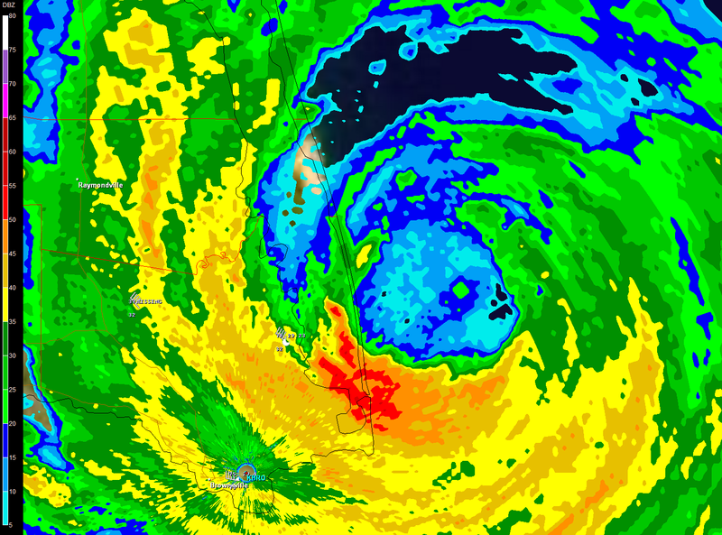
Yeah we all have her figured out pretty well. I think the NHC had her making landfall
at midday. That is obviously not going to be the case per the radar loop below.


http://radar.weather.gov/radar.php?rid= ... 1&loop=yes


It WILL be midday when this hits....


Are we talking about Eastern or Central time? Either way I think Midday means 12 noon in my book and it won't be making landfall in 25 minutes.


I consider midday to be the noon hour. I believe that it will make landfall at SPI before 1:00 CDT
0 likes   

cpdaman
Category 5
Category 5
Posts: 3131
Joined: Sat Jun 10, 2006 11:44 am
Location: SPB county (gulf stream)

#7902 Postby cpdaman » Wed Jul 23, 2008 11:45 am

latest minimum pressure found by recon is 973
0 likes   

CrazyC83
Professional-Met
Professional-Met
Posts: 34002
Joined: Tue Mar 07, 2006 11:57 pm
Location: Deep South, for the first time!

#7903 Postby CrazyC83 » Wed Jul 23, 2008 11:45 am

One thing I wouldn't be surprised is that the actual land winds go beyond that of the Recon.
0 likes   

User avatar
mutley
S2K Supporter
S2K Supporter
Posts: 311
Joined: Wed Aug 15, 2007 7:18 am
Location: Gainesville, FL

#7904 Postby mutley » Wed Jul 23, 2008 11:46 am

Just wanted to mention that fox news has a live stream, I think from SPI. Video from inside a vehicle driving around.
0 likes   

MWatkins
S2K Supporter
S2K Supporter
Posts: 2574
Joined: Sat Oct 12, 2002 7:51 pm
Location: SE Florida
Contact:

Re: ATL: H Dolly in Western Gulf of Mexico

#7905 Postby MWatkins » Wed Jul 23, 2008 11:48 am

Latest Vortex message (sure this in the recon thread too) from about 30 mins ago suggests the intensification trend has leveled off with pressure hanging at 967MB.

Also...Brownsville radar is showing a definitive wobble to the west in the last hour or so.

MW
0 likes   

Ed Mahmoud

Re: ATL: H Dolly in Western Gulf of Mexico

#7906 Postby Ed Mahmoud » Wed Jul 23, 2008 11:48 am

Waterpouts in CRP and rain wrapped tornadoes or funnels near Los Fresnos, isolated pockets of more severe damage possible at a distance from landfall point and areas receiving max sustained winds.
0 likes   

User avatar
WmE
Category 2
Category 2
Posts: 696
Age: 36
Joined: Sat Jun 17, 2006 11:23 am
Location: Vienna, Austria

Re:

#7907 Postby WmE » Wed Jul 23, 2008 11:49 am

mutley wrote:Just wanted to mention that fox news has a live stream, I think from SPI. Video from inside a vehicle driving around.


Does anybody have a link please?
0 likes   

User avatar
HarlequinBoy
Category 5
Category 5
Posts: 1400
Age: 34
Joined: Wed Nov 29, 2006 1:57 am
Location: Memphis

Re:

#7908 Postby HarlequinBoy » Wed Jul 23, 2008 11:49 am

cpdaman wrote:latest minimum pressure found by recon is 973


I think the VDM found 967?
0 likes   

MiamiensisWx

#7909 Postby MiamiensisWx » Wed Jul 23, 2008 11:50 am

It seems like the strongest winds are situated in the N and E quadrants (as opposed to the S and W ones) per recon FL winds. This corrobates with latest observations from Port Isabel in the eyewall, which show 54 kt winds.

KPIL:

http://weather.noaa.gov/weather/current/KPIL.html
Last edited by MiamiensisWx on Wed Jul 23, 2008 11:51 am, edited 1 time in total.
0 likes   

User avatar
mutley
S2K Supporter
S2K Supporter
Posts: 311
Joined: Wed Aug 15, 2007 7:18 am
Location: Gainesville, FL

Re: Re:

#7910 Postby mutley » Wed Jul 23, 2008 11:50 am

WmE wrote:
mutley wrote:Just wanted to mention that fox news has a live stream, I think from SPI. Video from inside a vehicle driving around.


Does anybody have a link please?

http://www.foxnews.com/index.html
0 likes   

Derek Ortt

#7911 Postby Derek Ortt » Wed Jul 23, 2008 11:50 am

based upon the data, it seems as if the winds have decreased somewhat
0 likes   

JonathanBelles
Professional-Met
Professional-Met
Posts: 11430
Age: 35
Joined: Sat Dec 24, 2005 9:00 pm
Location: School: Florida State University (Tallahassee, FL) Home: St. Petersburg, Florida
Contact:

#7912 Postby JonathanBelles » Wed Jul 23, 2008 11:51 am

Brownsville seems to be spared from the full force winds.
0 likes   

Derek Ortt

#7913 Postby Derek Ortt » Wed Jul 23, 2008 11:51 am

port isabel is not yet in the eyewall
0 likes   

User avatar
KWT
Category 5
Category 5
Posts: 31415
Joined: Tue Aug 17, 2004 11:02 am
Location: UK!!!

#7914 Postby KWT » Wed Jul 23, 2008 11:51 am

I think we are going to have landfall very soon, probably an hour or so away from landfall IMO.

Derek, I'd go with 90mph right now, still a pretty strong category-1 and still going to cause pretty bad damage, hardly surprising it may be starting to weaken so close to land.
Last edited by KWT on Wed Jul 23, 2008 11:52 am, edited 1 time in total.
0 likes   

User avatar
Chacor
Category 5
Category 5
Posts: 10229
Joined: Mon Oct 02, 2006 10:43 pm
Location: Singapore

Re:

#7915 Postby Chacor » Wed Jul 23, 2008 11:51 am

Corpus Christi, Corpus Christi Naval Air Station/Truax Field, TX
KNGP 231637Z AUTO 05027G33KT 1 3/4SM +RA BR SCT017 26/24 A2976 RMK AO2 PK WND 05033/1629 TSE04RAE03B21 P0002

Brownsville, Brownsville / South Padre Island International Airport, TX
KBRO 231646Z 28037G58KT 3/4SM +RA BR FEW009 OVC015 24/23 A2940 RMK AO2 PK WND 27058/1644 P0027

Harlingen, Rio Grande Valley International Airport, TX
KHRL 231648Z 32040G52KT 2SM RA BR SCT009 OVC014 24/22 A2945 RMK AO2 PK WND 32056/1606 P0012

Port Isabel, Port Isabel-Cameron County Airport, TX
KPIL 231631Z AUTO 31047G61KT 1/4SM +RA BKN007 OVC014 26/ A2923 RMK AO2 PK WND 31061/1627 P0046
0 likes   

RL3AO
Moderator-Pro Met
Moderator-Pro Met
Posts: 16308
Joined: Thu Jun 14, 2007 10:03 pm
Location: NC

Re: Re:

#7916 Postby RL3AO » Wed Jul 23, 2008 11:52 am

HarlequinBoy wrote:
cpdaman wrote:latest minimum pressure found by recon is 973


I think the VDM found 967?


Dropsonde showed 967.

000
UZNT13 KNHC 231647
XXAA 73167 99262 70970 08267 99967 25400 18505 00799 ///// /////
92390 24401 17504 85132 21402 19002 70814 17257 23507 88999 77999
31313 09608 81629
0 likes   

rblock06
Tropical Wave
Tropical Wave
Posts: 3
Age: 37
Joined: Wed May 28, 2008 4:33 am

#7917 Postby rblock06 » Wed Jul 23, 2008 11:52 am

0 likes   

User avatar
Chacor
Category 5
Category 5
Posts: 10229
Joined: Mon Oct 02, 2006 10:43 pm
Location: Singapore

#7918 Postby Chacor » Wed Jul 23, 2008 11:53 am

WWUS84 KBRO 231653
SPSBRO

SPECIAL WEATHER STATEMENT
NATIONAL WEATHER SERVICE BROWNSVILLE TX
1153 AM CDT WED JUL 23 2008

TXZ254>257-231900-
INLAND WILLACY-INLAND CAMERON-COASTAL WILLACY-COASTAL CAMERON-
INCLUDING THE CITIES OF...RAYMONDVILLE...BROWNSVILLE...
HARLINGEN...PORT MANSFIELD...PORT ISABEL...SOUTH PADRE ISLAND...
LAGUNA HEIGHTS...LAGUNA VISTA
1153 AM CDT WED JUL 23 2008

...STRONG WINDS LASHING THE COAST...

STRONG TROPICAL STORM TO HURRICANE FORCE WINDS ARE LASHING CAMERON
AND WILLACY COUNTY AT THIS TIME...AS THE EYE OF POWERFUL HURRICANE
DOLLY APPROACHES FROM THE EAST-SOUTHEAST.

REPORTS FROM THE PUBLIC AND COUNTY OFFICIALS INDICATE THAT DAMAGE
TO STRUCTURES...UTILITY LINES...AND TREES HAS OCCURRED...AND IS
OCCURRING...IN THE CITIES OF SOUTH PADRE ISLAND AND PORT ISABEL.
ADDITIONAL DAMAGE HAS ALSO BEEN REPORTED IN BROWNSVILLE AND
HARLINGEN.

RESIDENTS ARE URGED TO REMAIN SHELTERED INDOORS. DO NOT GO OUTSIDE
TO REMOVE DEBRIS WHEN THE EYE OF HURRICANE DOLLY MOVES ONSHORE...
AS DAMAGED TREES...POWERLINES...AND BUILDINGS WILL BE HAZARDOUS TO
ANYONE OUTDOORS.

$$

TOMASELLI
0 likes   

RL3AO
Moderator-Pro Met
Moderator-Pro Met
Posts: 16308
Joined: Thu Jun 14, 2007 10:03 pm
Location: NC

#7919 Postby RL3AO » Wed Jul 23, 2008 11:54 am

8nm east of Padre Island.

Image
0 likes   

User avatar
funster
Category 3
Category 3
Posts: 816
Joined: Sat Dec 29, 2007 4:27 pm
Location: North Dallas

#7920 Postby funster » Wed Jul 23, 2008 11:54 am

Earlier this morning it was looking more like Dolly would come in south of the border. I thought the forecast had it turning more westerly before landfall not more north? Just shows how hard it is to accurately predict hurricanes.
0 likes   


Return to “2008”

Who is online

Users browsing this forum: No registered users and 4 guests