
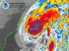
IR loop shows rapidly cooling cloud tops and it's expanding.
http://www.ssd.noaa.gov/PS/TROP/DATA/RT ... -loop.html
Strenthening?
Moderator: S2k Moderators
Forum rules

The posts in this forum are NOT official forecasts and should not be used as such. They are just the opinion of the poster and may or may not be backed by sound meteorological data. They are NOT endorsed by any professional institution or STORM2K. For official information, please refer to products from the National Hurricane Center and National Weather Service.
-
vbhoutex

- Storm2k Executive

- Posts: 29150
- Age: 74
- Joined: Wed Oct 09, 2002 11:31 pm
- Location: Cypress, TX
- Contact:
Re: Strenthening?
Tip wrote:IR loop shows rapidly cooling cloud tops and it's expanding.
http://www.ssd.noaa.gov/PS/TROP/DATA/RT ... -loop.html
And she probably is beginning a strengthening cycle since she is in a good postion to do so. The Yuc peninsula will do little to inhibit this since the majority of the circulation is over very warm waters.
0 likes
Skywarn, C.E.R.T.
Please click below to donate to STORM2K to help with the expenses of keeping the site going:

Please click below to donate to STORM2K to help with the expenses of keeping the site going:
-
GulfBreezer

- Category 5

- Posts: 2230
- Joined: Wed Oct 09, 2002 8:58 pm
- Location: Gulf Breeze Fl
- Contact:
-
wx247

- S2K Supporter

- Posts: 14279
- Age: 42
- Joined: Wed Feb 05, 2003 10:35 pm
- Location: Monett, Missouri
- Contact:
She does look better organized than she did late last night. What happened to the upper low? Is it out of the picture now?
0 likes
Personal Forecast Disclaimer:
The posts in this forum are NOT official forecast and should not be used as such. They are just the opinion of the poster and may or may not be backed by sound meteorological data. They are NOT endorsed by any professional institution or storm2k.org. For official information, please refer to the NHC and NWS products.
The posts in this forum are NOT official forecast and should not be used as such. They are just the opinion of the poster and may or may not be backed by sound meteorological data. They are NOT endorsed by any professional institution or storm2k.org. For official information, please refer to the NHC and NWS products.
-
flightpath
- Tropical Low

- Posts: 35
- Joined: Sun May 11, 2003 10:27 pm
- Location: metairie,LA
I see the expansion beginning to take place- nice look at it on water vapor loop- http://orca.rsmas.miami.edu/wximages/jet/1_29/anis.html
0 likes


Who is online
Users browsing this forum: Blown Away, HurricaneFan and 385 guests