
ATL: Dolly Model Runs
Moderator: S2k Moderators
-
Wx_Warrior
- Category 5

- Posts: 2718
- Joined: Thu Aug 03, 2006 3:58 pm
- Location: Beaumont, TX

-
Ed Mahmoud
Re: ATL: TS Dolly Model Runs

0 likes
-
Wx_Warrior
- Category 5
- Posts: 2718
- Joined: Thu Aug 03, 2006 3:58 pm
- Location: Beaumont, TX

-
cycloneye

- Admin

- Posts: 149815
- Age: 69
- Joined: Thu Oct 10, 2002 10:54 am
- Location: San Juan, Puerto Rico
Re: ATL: TS Dolly Model Runs
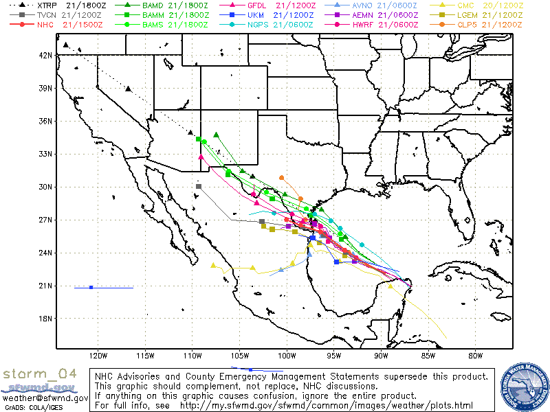
WHXX01 KWBC 221228
CHGHUR
TROPICAL CYCLONE GUIDANCE MESSAGE
NWS TPC/NATIONAL HURRICANE CENTER MIAMI FL
1228 UTC TUE JUL 22 2008
DISCLAIMER...NUMERICAL MODELS ARE SUBJECT TO LARGE ERRORS.
PLEASE REFER TO NHC OFFICIAL FORECASTS FOR TROPICAL CYCLONE
AND SUBTROPICAL CYCLONE INFORMATION.
ATLANTIC OBJECTIVE AIDS FOR
TROPICAL CYCLONE DOLLY (AL042008) 20080722 1200 UTC
...00 HRS... ...12 HRS... ...24 HRS. .. ...36 HRS...
080722 1200 080723 0000 080723 1200 080724 0000
LAT LON LAT LON LAT LON LAT LON
BAMS 23.7N 94.0W 24.7N 95.5W 25.6N 97.2W 25.8N 98.6W
BAMD 23.7N 94.0W 25.0N 95.5W 25.8N 96.6W 26.3N 97.8W
BAMM 23.7N 94.0W 24.7N 95.5W 25.3N 96.7W 25.7N 98.0W
LBAR 23.7N 94.0W 24.9N 95.6W 26.0N 97.1W 26.8N 98.4W
SHIP 55KTS 66KTS 73KTS 75KTS
DSHP 55KTS 66KTS 73KTS 52KTS
...48 HRS... ...72 HRS... ...96 HRS. .. ..120 HRS...
080724 1200 080725 1200 080726 1200 080727 1200
LAT LON LAT LON LAT LON LAT LON
BAMS 26.0N 100.5W 26.1N 105.0W 26.6N 109.6W 27.9N 113.6W
BAMD 26.4N 99.6W 26.8N 104.2W 28.0N 109.3W 30.0N 113.0W
BAMM 25.7N 99.7W 25.8N 104.2W 26.4N 109.4W 27.8N 113.8W
LBAR 27.7N 99.8W 29.8N 102.8W 31.8N 104.9W 33.3N 105.3W
SHIP 78KTS 78KTS 72KTS 64KTS
DSHP 35KTS 28KTS 27KTS 27KTS
...INITIAL CONDITIONS...
LATCUR = 23.7N LONCUR = 94.0W DIRCUR = 300DEG SPDCUR = 11KT
LATM12 = 23.0N LONM12 = 92.0W DIRM12 = 279DEG SPDM12 = 13KT
LATM24 = 21.9N LONM24 = 88.9W
WNDCUR = 55KT RMAXWD = 45NM WNDM12 = 45KT
CENPRS = 993MB OUTPRS = 1013MB OUTRAD = 240NM SDEPTH = D
RD34NE = 140NM RD34SE = 120NM RD34SW = 60NM RD34NW = 120NM
$$
0 likes
-
Extremeweatherguy

- Category 5
- Posts: 11095
- Joined: Mon Oct 10, 2005 8:13 pm
- Location: Florida


-
terstorm1012

- S2K Supporter

- Posts: 1314
- Age: 44
- Joined: Fri Sep 10, 2004 5:36 pm
- Location: Millersburg, PA
-
Ed Mahmoud
Re: ATL: TS Dolly Model Runs
terstorm1012 wrote:I think zulu time is the same as Greenwich Mean Time.
Texas is 5 hours behind in Summer.
19Z Zulu is 1400 local, or 2 pm.
0 likes

Re:
gboudx wrote:Central Daylight Time is 6 hours less than GMT. So, currently it's 12:17pm CDT which means 18:17 GMT.
When Daylight Savings time ends, CST will be 5 hours behind.
Other way around. CST = UTC-6, CDT = UTC-5.
0 likes

-
Ed Mahmoud
Re: ATL: TS Dolly Model Runs
12Z WRF shows landfall in Kenedy County, with about 8 inches of rain next 3 days in Corpus Christi. Per AccuWx PPV MOS. Which is given in inches.
I believe this model loop gives accumulated rainfall in mm. 400 mm would be about 8 inches.
I think flash flooding may wind up as big a problem as strong winds and coastal flooding. Note how WRF slows storm near landfall.
Will double post in main thread.
I believe this model loop gives accumulated rainfall in mm. 400 mm would be about 8 inches.
I think flash flooding may wind up as big a problem as strong winds and coastal flooding. Note how WRF slows storm near landfall.
Will double post in main thread.
0 likes
-
gboudx

- S2K Supporter
- Posts: 4090
- Joined: Thu Sep 04, 2003 1:39 pm
- Location: Rockwall, Tx but from Harvey, La
Re: Re:
RL3AO wrote:gboudx wrote:Central Daylight Time is 6 hours less than GMT. So, currently it's 12:17pm CDT which means 18:17 GMT.
When Daylight Savings time ends, CST will be 5 hours behind.
Other way around. CST = UTC-6, CDT = UTC-5.
OMG, my PC is wrong then. :covri:
0 likes
-
Ed Mahmoud
Re: ATL: TS Dolly Model Runs
Code: Select all
TROPICAL STORM DOLLY      ANALYSED POSITION : 23.8N  94.2W


     ATCF IDENTIFIER : AL042008


  VERIFYING TIME     POSITION     STRENGTH        TENDENCY

  --------------     --------     --------        --------

 12UTC 22.07.2008  23.8N  94.2W   MODERATE

 00UTC 23.07.2008  24.6N  95.9W    STRONG   INTENSIFYING RAPIDLY

 12UTC 23.07.2008  24.9N  96.6W   INTENSE   INTENSIFYING SLIGHTLY

 00UTC 24.07.2008  25.3N  97.6W    STRONG     WEAKENING RAPIDLY

 12UTC 24.07.2008  26.2N  99.3W    STRONG       LITTLE CHANGE

 00UTC 25.07.2008        BELOW TROPICAL STORM STRENGTH
0 likes
-
brunota2003

- S2K Supporter
- Posts: 9476
- Age: 35
- Joined: Sat Jul 30, 2005 9:56 pm
- Location: Stanton, KY...formerly Havelock, NC
- Contact:
-
Ed Mahmoud
Re:
brunota2003 wrote:What model run is that? Suggesting IR tonight...my "Unofficial" statements have been saying Cat 2 since it was forecast to be a hurricane, because you never know...
UK Met tropical model text product, and I have no idea what "intense" means in their system.
0 likes
-
brunota2003
- S2K Supporter
- Posts: 9476
- Age: 35
- Joined: Sat Jul 30, 2005 9:56 pm
- Location: Stanton, KY...formerly Havelock, NC
- Contact:
Who is online
Users browsing this forum: No registered users and 28 guests