H Dolly Recon Discussion Thread
Moderator: S2k Moderators
-
Ed Mahmoud
Re: Invest 94L Recon Discussion Thread
Aric Dunn wrote:Ed Mahmoud wrote:If the center is indeed still South of 15ºN, unofficially I'd say it is very unlikely this landfalls North of the Rio Grande. SPI might still get some seas and squalls, but, in my amateur opinion, this is a two landfall Mexico threat.
the problem with saying that is if this is the center trying to form then that just means we have a td/ts. becasue at this early stage the center is weak and will shift and most likely be pulled closer the the convection further north and or reform. my point is we cant just say its not going to go somewhere based on the inital center formation ..
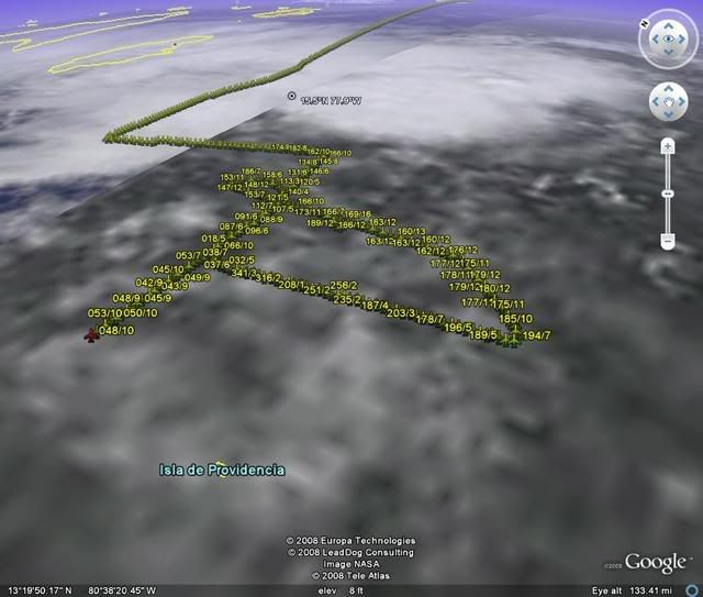
yeah, the apparent mid-level circulation on satellite looks closer to 15.5ºN and 77.5ºW, and maybe a new LLC might develop under that. maybe.
0 likes


-
Matt-hurricanewatcher
Re: Invest 94L Recon Discussion Thread
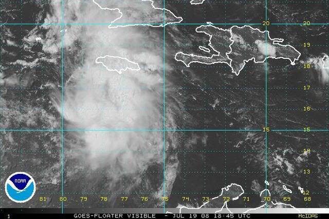
Looks like the recon is not going to find a LLC today. On the other hand Christoball is looking interesting.
0 likes
-
Aric Dunn
- Category 5

- Posts: 21238
- Age: 43
- Joined: Sun Sep 19, 2004 9:58 pm
- Location: Ready for the Chase.
- Contact:
lastes close up sat loops showing something in that area.. its hard to tell but it appears to be some in flow , cloud lines , or an illussion.
http://weather.msfc.nasa.gov/GOES/goeseastconus.html
high zoom 30 images..
http://weather.msfc.nasa.gov/GOES/goeseastconus.html
high zoom 30 images..
0 likes
-
Matt-hurricanewatcher
Re: Invest 94L Recon Discussion Thread
I would look around 15.4/79.5 for a LLC to develop if ones going to develop. Out ahead of the convection is not very likley.
0 likes
-
Ed Mahmoud
Re: Invest 94L Recon Discussion Thread
hurricanelandfall wrote:I still tend to favor the 00z GFDL scenario where a powerful hurricane heads NW and N. In the grand scheme of things 2 deg N is not a big deal.Ed Mahmoud wrote:If the center is indeed still South of 15ºN, unofficially I'd say it is very unlikely this landfalls North of the Rio Grande. SPI might still get some seas and squalls, but, in my amateur opinion, this is a two landfall Mexico threat.
I'll wear nothing but a thong on my pasty white butt on my 200 lb body and walk around my neighborhood screaming "I'm an idiot" if a Cat 5, or a Cat 4, makes landfall withing 100 miles of Houston next week.
I'd throw in Cat 3, but that is tempting fate too much. But my serious, if unofficial hunch, a storm like Claudette, but further South, is a worst case scenario.
0 likes

Re: Invest 94L Recon Discussion Thread
strange that RECON is flying out to the west well away from convection.
0 likes
-
Ed Mahmoud
Re: Invest 94L Recon Discussion Thread
ROCK wrote:strange that RECON is flying out to the west well away from convection.
yeah, if I were King of the World, the AC would fly around some more near the possible MLC near 15º and 78º to see if something is trying to get going there.
But this does seem to confirm my hunch that 94L, while healthier, still isn't healthy, and it'll be a real stretch to upgrade it today.
0 likes
-
southerngale

- Retired Staff

- Posts: 27418
- Joined: Thu Oct 10, 2002 1:27 am
- Location: Southeast Texas (Beaumont area)
Re: Invest 94L Recon Discussion Thread
hurricanelandfall wrote:I still tend to favor the 00z GFDL scenario where a powerful hurricane heads NW and N. In the grand scheme of things 2 deg N is not a big deal.Ed Mahmoud wrote:If the center is indeed still South of 15ºN, unofficially I'd say it is very unlikely this landfalls North of the Rio Grande. SPI might still get some seas and squalls, but, in my amateur opinion, this is a two landfall Mexico threat.
Why do you favor that? It was only one run, and an outlier.
0 likes
-
Seadootoo
- S2K Supporter

- Posts: 36
- Age: 62
- Joined: Tue Jun 10, 2003 10:07 pm
- Location: Corpus Christi, Texas
Re: Invest 94L Recon Discussion Thread
maybe they are doing some sampling for the next model runs
0 likes
-
Brent
- S2K Supporter
- Posts: 38790
- Age: 37
- Joined: Sun May 16, 2004 10:30 pm
- Location: Tulsa Oklahoma
- Contact:
Re: Invest 94L Recon Discussion Thread
Ed Mahmoud wrote:hurricanelandfall wrote:I still tend to favor the 00z GFDL scenario where a powerful hurricane heads NW and N. In the grand scheme of things 2 deg N is not a big deal.Ed Mahmoud wrote:If the center is indeed still South of 15ºN, unofficially I'd say it is very unlikely this landfalls North of the Rio Grande. SPI might still get some seas and squalls, but, in my amateur opinion, this is a two landfall Mexico threat.
I'll wear nothing but a thong on my pasty white butt on my 200 lb body and walk around my neighborhood screaming "I'm an idiot" if a Cat 5, or a Cat 4, makes landfall withing 100 miles of Houston next week.


0 likes
-
brunota2003

- S2K Supporter
- Posts: 9476
- Age: 35
- Joined: Sat Jul 30, 2005 9:56 pm
- Location: Stanton, KY...formerly Havelock, NC
- Contact:
-
HurricaneHunter914
- Category 5
- Posts: 4439
- Age: 32
- Joined: Fri Mar 10, 2006 7:36 pm
- Location: College Station, TX
-
weatherguru18
Re: Invest 94L Recon Discussion Thread
Ed Mahmoud wrote:hurricanelandfall wrote:I still tend to favor the 00z GFDL scenario where a powerful hurricane heads NW and N. In the grand scheme of things 2 deg N is not a big deal.Ed Mahmoud wrote:If the center is indeed still South of 15ºN, unofficially I'd say it is very unlikely this landfalls North of the Rio Grande. SPI might still get some seas and squalls, but, in my amateur opinion, this is a two landfall Mexico threat.
I'll wear nothing but a thong on my pasty white butt on my 200 lb body and walk around my neighborhood screaming "I'm an idiot" if a Cat 5, or a Cat 4, makes landfall withing 100 miles of Houston next week.
I'd throw in Cat 3, but that is tempting fate too much. But my serious, if unofficial hunch, a storm like Claudette, but further South, is a worst case scenario.
God I hope not!! (I was actually talking about you in the thong, not the hurricane. LOL)
0 likes
-
HurricaneHunter914
- Category 5
- Posts: 4439
- Age: 32
- Joined: Fri Mar 10, 2006 7:36 pm
- Location: College Station, TX
Who is online
Users browsing this forum: No registered users and 41 guests