


ATL: Tropical Storm Cristobal in North Atlantic
Moderator: S2k Moderators

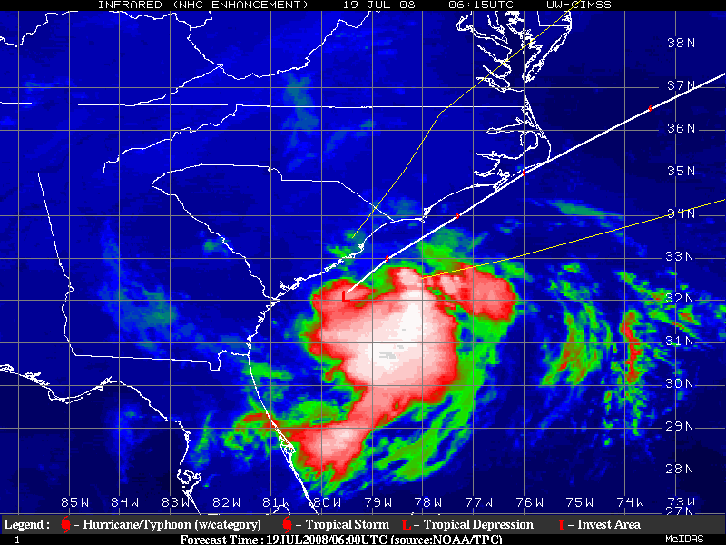
Re: ATL: Tropical Depression Three near Southeast U.S
Looks like a center popping out on the latest visible floater loop.

0 likes
-
wx247

- S2K Supporter

- Posts: 14279
- Age: 42
- Joined: Wed Feb 05, 2003 10:35 pm
- Location: Monett, Missouri
- Contact:
Re:
storms in NC wrote:This thread is dead.I guess 94L is more fun.
This system isn't like to turn into a super cat 5. That is why a lot of people aren't paying attention. If this turns into a named storm with a little bit higher winds...watch people flock to this thread. For so many, it isn't about the love of weather and tropical systems... but rather the hype and end of the world scenarios.
To stay topical... looks like TD may be getting stronger. Should be interesting to see what Recon finds.
0 likes

Re: Re:
wx247 wrote:storms in NC wrote:This thread is dead.I guess 94L is more fun.
This system isn't like to turn into a super cat 5. That is why a lot of people aren't paying attention. If this turns into a named storm with a little bit higher winds...watch people flock to this thread. For so many, it isn't about the love of weather and tropical systems... but rather the hype and end of the world scenarios.
To stay topical... looks like TD may be getting stronger. Should be interesting to see what Recon finds.
it's near tropical storm strength according the the NHC.
i seriously doubt 94L ever reaches hurricane strength.
0 likes
-
storms in NC

- S2K Supporter
- Posts: 2338
- Joined: Thu Jul 28, 2005 2:58 pm
- Location: Wallace,NC 40 miles NE of Wilm
- Contact:

-
storms in NC
- S2K Supporter
- Posts: 2338
- Joined: Thu Jul 28, 2005 2:58 pm
- Location: Wallace,NC 40 miles NE of Wilm
- Contact:
Re: ATL: Tropical Depression Three near Southeast U.S
32/ 78.2 ? cant copy and paste on this comp (using cntrl C) so you will have to look at latest visible on your own
center finally seems like it has decided to become better organized at the location (further offshore) i mentioned above. puts it in good place to strengthen ,should that verify IMO
plane will confirm or deny at 1pm
center finally seems like it has decided to become better organized at the location (further offshore) i mentioned above. puts it in good place to strengthen ,should that verify IMO
plane will confirm or deny at 1pm
0 likes
-
Just Joshing You

- Category 2

- Posts: 512
- Joined: Sat Nov 03, 2007 10:29 am
- Location: Nova Scotia
-
Stephanie

- S2K Supporter
- Posts: 23843
- Age: 63
- Joined: Thu Feb 06, 2003 9:53 am
- Location: Glassboro, NJ
Re: ATL: Tropical Depression Three near Southeast U.S
Recurve wrote:Looks like a center popping out on the latest visible floater loop.
It does, doesn't it?
Very good, symetrical form. I'm amazed at how well TD3 got it together so close to the coast.
0 likes
-
'CaneFreak

- Category 5

- Posts: 1487
- Joined: Mon Jun 05, 2006 10:50 am
- Location: New Bern, NC
Re: ATL: Tropical Depression Three near Southeast U.S
Stephanie wrote:Recurve wrote:Looks like a center popping out on the latest visible floater loop.
It does, doesn't it?
Very good, symetrical form. I'm amazed at how well TD3 got it together so close to the coast.
on second look , i changed mymind. i dont think she has it together yet, next frame kinda eroded that center image and convection has pulsed down, so far i think she has abroad llc
bout 32ish 78.6 ish
0 likes
-
Ed Mahmoud
Re: ATL: Tropical Depression Three near Southeast U.S
Looking at Wilmington long range (low res) radar, I see what may be more than a single center of circulation. Perhaps one is the top of the low level center just being grazed by the radar beam shooting over its top, or there may still be a couple of centers still competing to be the top dog.
0 likes
-
vbhoutex

- Storm2k Executive

- Posts: 29151
- Age: 74
- Joined: Wed Oct 09, 2002 11:31 pm
- Location: Cypress, TX
- Contact:
Re: ATL: Tropical Depression Three near Southeast U.S
I think you've made a pretty good assessment there Ed. It will be interesting to see what the plane finds when it gets there. It is definitely getting better looking and appearing to consolidate. I haven't looked at winds, but TD3 looks alot helathier than 94L does. Cristobal within the next 36 hours would not be a big surprise to me.
0 likes
-
Hybridstorm_November2001

- S2K Supporter
- Posts: 2817
- Joined: Sat Aug 21, 2004 2:50 pm
- Location: SW New Brunswick, Canada
- Contact:
Re: ATL: Tropical Depression Three near Southeast U.S
Interesting mention made of TD 3 for general area, from Caribou office:
000
FXUS61 KCAR 190718
AFDCAR
AREA FORECAST DISCUSSION
NATIONAL WEATHER SERVICE CARIBOU ME
318 AM EDT SAT JUL 19 2008
.LONG TERM /MONDAY NIGHT THROUGH FRIDAY/...
-- Changed Discussion --LOADED THE GMOS FOR THE LONG TERM WITH SOME MINOR TWEAKS. FRONT
REMAINS STATIONARY OVER THE COAST MONDAY NIGHT INTO THE MIDDLE OF
THE WEAK AS UPPER TROUGH CONTINUES TO DIG ACROSS THE NORTHEAST.
ANOTHER FACTOR MAY BE TD #3 CURRENTLY OFF THE CAROLINA COAST. MODELS
CONTINUE TO MOVE THIS FEATURE UP THE EAST COAST AND EVENTUALLY
INTERACTING IT WITH THE FRONT ALONG THE MAINE COAST ENHANCING
SHOWERS AND THUNDERSTORMS TUESDAY INTO WEDNESDAY. A LOT OF
UNCERTAINTY IN THE LONG TERM DUE TO THE MOVEMENT OF THIS TROPICAL
FEATURE.-- End Changed Discussion --
&&
Source:
http://www.crh.noaa.gov/product.php?site=NWS&issuedby=CAR&product=AFD&format=CI&version=1&glossary=1&highlight=off
0 likes
-
storms in NC
- S2K Supporter
- Posts: 2338
- Joined: Thu Jul 28, 2005 2:58 pm
- Location: Wallace,NC 40 miles NE of Wilm
- Contact:
-
Hybridstorm_November2001
- S2K Supporter
- Posts: 2817
- Joined: Sat Aug 21, 2004 2:50 pm
- Location: SW New Brunswick, Canada
- Contact:
DISCLAIMER THE BELOW IS A PERSONAL FORECAST, AND IS IN NO WAY OFFICIALLY ASSOCIATED WITH STORM2K, NHC/TCP, ENVIRONMENT CANADA, OR ANY OTHER ENTITY.
I'll go out on a limb here, and say I think Nova Scotia will get the worst of this one (if any place does at all that is), because it may very well end up on the eastern side of the track/system. Just my two cents worth.
I'll go out on a limb here, and say I think Nova Scotia will get the worst of this one (if any place does at all that is), because it may very well end up on the eastern side of the track/system. Just my two cents worth.
0 likes
Who is online
Users browsing this forum: No registered users and 46 guests