Hmmm... floater 1 is on Bertha, floater 2 is on 94L, floater 3 is on 95L, and floater 4 is in the vicinity of 96L, but timestamp is from July 13... anyone know why it's not active on 96L?
http://www.ssd.noaa.gov/goes/flt/t4/vis-l.jpg
ATL: Tropical Storm Cristobal in North Atlantic
Moderator: S2k Moderators


-
Ed Mahmoud
Re: ATL: INVEST 96L near Southeast US
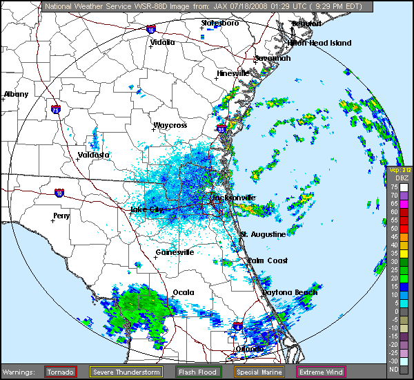
Maybe the models are drifitng this Northwest is because it is drifting Northwest. Subtle, but I think I see a slow Westward drift on that radar.
I'd say a sure fire lock to develop, if it stays offshore, which is the big question.
I'd say a sure fire lock to develop, if it stays offshore, which is the big question.
0 likes
-
O Town
- S2K Supporter

- Posts: 5205
- Age: 52
- Joined: Wed Sep 07, 2005 9:37 pm
- Location: Orlando, Florida 28°35'35"N 81°22'55"W
Ed Mahmoud wrote:Maybe the models are drifitng this Northwest is because it is drifting Northwest. Subtle, but I think I see a slow Westward drift on that radar.
I'd say a sure fire lock to develop, if it stays offshore, which is the big question.
Yes, it does seem to have moved slightly......back towards me. lol.
I was hoping it would start moving NE and give us a much needed rain break.
0 likes


Re: ATL: INVEST 96L near Southeast US
orion wrote:I've got radar loop superimposed on sat image of this area running on my site for those interested...
http://orionweather.net/index.php?content=radar.html
I will update the radar site as needed to follow the system.
Good stuff! I have checked your site before, but the upgrades are A++.
I'm flying to JAX Fri night and driving back on Sun/Mon - hope things aren't too stormy for anyone in my path.
0 likes
-
JonathanBelles
- Professional-Met

- Posts: 11430
- Age: 35
- Joined: Sat Dec 24, 2005 9:00 pm
- Location: School: Florida State University (Tallahassee, FL) Home: St. Petersburg, Florida
- Contact:
-
'CaneFreak

- Category 5

- Posts: 1487
- Joined: Mon Jun 05, 2006 10:50 am
- Location: New Bern, NC
I think the key player in future intensity with 96L maybe be what happens with the Upper level low that has established itself over the SW Atlantic as it is heading WESTWARD and causing an overamplification of the outflow on the SE side of this system. The other key factor is the track of the upper level high pressure system that is currently positioned to the west of 96L. Right now, it is causing some northerly upper level shear over the system at around 15 knots which is not really impeding development but not helping it. If it can establish itself directly over this system and the outflow does not become impeded by the ULL, I don't see why this can't make it to hurricane status by the end of this weekend especially given the 84 to 85 degree SSTs and the Gulf Stream's OHC. Also, the proximity of the ULL to this system is also feeding this system in that it is keeping the 250 mb temperatures down and that is what you need to keep the instability high and keep the thunderstorms going. Its that difference in temperatures between 250 mb and the ocean surface that keeps the thunderstorms firing. This is all hinges on the track of the system of course. Steering currents are weak and a movement like that of Hurricane Ophelia of 2005 can be expected. This is just my unprofessional opinion. Don't use my analysis to cancel any vacation plans. Go to your destination and enjoy yourself. This has been brought to you by a member of Storm2k.org. 
0 likes
-
orion

- S2K Supporter
- Posts: 165
- Joined: Mon Aug 02, 2004 5:44 pm
- Location: Indian Harbour Beach, FL
- Contact:
Re: ATL: INVEST 96L near Southeast US
gotoman38 wrote:orion wrote:I've got radar loop superimposed on sat image of this area running on my site for those interested...
http://orionweather.net/index.php?content=radar.html
I will update the radar site as needed to follow the system.
Good stuff! I have checked your site before, but the upgrades are A++.
I'm flying to JAX Fri night and driving back on Sun/Mon - hope things aren't too stormy for anyone in my path.
Hey, thanks! Have a safe trip.
Yeah, right now looks like 96L has no where to go - basically no steering currents as OTown said. Local NWS (KMHX) says:
IN THE NEAR TERM...WINDS WILL GRADUALLY VEER AS HIGH MOVES
OFFSHORE TO THE NORTH TNGT THRU FRI. SPEEDS GENERALLY 15 KT OR
LESS WITH LIGHTER WINDS UP N WHERE PRES GRAD IS WEAKER.
RSET OF MARINE FCST TRICKY AS IT HINGES HEAVILY ON EVENTUAL TRACK
AND INTENSITY OF LOW PRES NOW OFF GA COAST. HAVE LARGELY
DISCOUNTED FOR NOW THE WORST CASE NAM SOLN OF A RAPIDLY DEEPENING
SYSTEM OFF THE NC/SC BORDER ON SUNDAY ALTHO THIS WILL NEED TO BE
WATCHED CLOSELY OVER THE NEXT DAY OR TWO.
0 likes
Re: ATL: INVEST 96L near Southeast US
Very welcome sir - again - Good Job!
Greg Fishel on WRAL is quoting his models that intensify 96L and track it N - but he has low confidence in them and as of 6 he was waiting for more data.... he's a top notch pro-wx and I have been following him for 20+ years - stay notched in down there!
0 likes
Re: ATL: INVEST 96L near Southeast US
very nice link orion , i also like the current wind data on the stations.
0 likes
Re: ATL: INVEST 96L near Southeast US
cpdaman wrote:very nice link orion , i also like the current wind data on the stations.
Yeah - very nice overlay with sat, radar and wind station obs.
On topic - 96L seems to be stationary to this hour - recon sched for Saturday?
0 likes
-
PTrackerLA

- Category 5
- Posts: 5281
- Age: 42
- Joined: Thu Oct 10, 2002 8:40 pm
- Location: Lafayette, LA
My feelings are that we could see a minimal TS out of this but I think this system will mainly be a benefit to those suffering with drought. And about TWC, I can hardly watch it (even though it looks great in HD now) because it's simply not that much about weather now and more about agendas. It's agonizingly redundant with type of message they are trying to portray and I'll leave it as that. Thank god for the internet.
0 likes

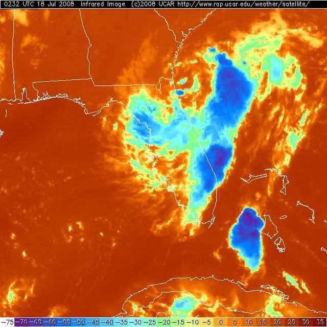
AN AREA OF LOW PRESSURE JUST OFF THE SOUTHERN GEORGIA COAST IS
PRODUCING SHOWERS AND GUSTY WINDS MAINLY OVER WATER. ENVIRONMENTAL
CONDITIONS ARE EXPECTED TO BECOME A LITTLE MORE FAVORABLE FOR
DEVELOPMENT DURING THE NEXT COUPLE OF DAYS...AND THERE IS A
POTENTIAL FOR A TROPICAL DEPRESSION TO FORM...ESPECIALLY IF THE LOW
REMAINS OFFSHORE. THIS SYSTEM IS EXPECTED TO DRIFT TO THE NORTH OR
NORTH-NORTHEAST.
0 likes

-
Matt-hurricanewatcher
Re:
KWT wrote:Convection is firing near the LLC it sstill not stunningly organised but I suppose if it can hold the recent burst of convection then it could strengthen pretty readily.
Surprised this one isn't getting more attention to be honest!
It has a 50/50 chance of making landfall within the next 6 hours. It is just so freaking close to land right now. But anyways the Gfdl doe's show it moving northeastward after 24 hours...So it may have a chance.
I will start taking it a little more seriously if it stays off intil tomarrow afternoon. NOT UNTIL THEN!
0 likes
Indeed Matt. the other issue is thereis a wall of dry air that seems like its starting to get injested into the circulation somewhat:
http://www.ssd.noaa.gov/goes/flt/t4/sloop-wv.html
http://www.ssd.noaa.gov/goes/flt/t4/sloop-wv.html
0 likes
Who is online
Users browsing this forum: No registered users and 77 guests