ATL: Tropical Depression Dolly
Moderator: S2k Moderators

-
Derek Ortt

Its a hard one to call Hurakan, the NHC may decide that its finally held convection for long enough near the center to upgrade, equally they may just decide to wait for recon and risk the chance that it won't decay again in the 15-18hrs time gap.
Crazy, yep 2.0 would warrent a 30kt depression if they decided to go with it, I personally think they will wait for recon but its not dead yet it seems!
Crazy, yep 2.0 would warrent a 30kt depression if they decided to go with it, I personally think they will wait for recon but its not dead yet it seems!
0 likes
-
Derek Ortt

Well its weakened Derek but then again its heading towards Dmin, I would expect siome weakening to occur. Also upper level winds aren't that bad, they are certainly marginal IMO just for now on the right side still.
If convection continues to decrease then I will agree, its a watch and wait game to be honest.
If convection continues to decrease then I will agree, its a watch and wait game to be honest.
0 likes
-
Derek Ortt
-
SouthFloridawx

- S2K Supporter

- Posts: 8346
- Age: 47
- Joined: Tue Jul 26, 2005 1:16 am
- Location: Sarasota, FL
- Contact:
-
Derek Ortt
-
Ed Mahmoud
Re: ATL: INVEST 94L East of the Windward Islands
When no model but the CMC has this develop anymore, the SHIPs shows near steady state and high shear, the GFDL loses it almost immediately, and the two most frequent pro-mets both declare it dead, if I ran the Storm2K Sports Book, I'd give this 11-2 odds of ever being a tropical cyclone in the Atlantic Basin.
I was as hyped as anyone yesterday, but this is a Pacific storm, at best.
The next MJO active phase arrives mid-August, and I suspect Joe B is right, that will be a track race.
I was as hyped as anyone yesterday, but this is a Pacific storm, at best.
The next MJO active phase arrives mid-August, and I suspect Joe B is right, that will be a track race.
0 likes
-
Derek Ortt
Indeed Ed it may wel be the case it does nothing right now but who knows really, I think its the best its looked right now even though apperence does sometimes lie!
Also whilst off topic, the next phase of the MJO will probably come through just for the peak of the season.
Derek, well thats what I thought when I first saw that estimate but now I think probably 1.5 is a better estimate. Still with 2.0 they will probably fly in if it holds like that.
Also whilst off topic, the next phase of the MJO will probably come through just for the peak of the season.
Derek, well thats what I thought when I first saw that estimate but now I think probably 1.5 is a better estimate. Still with 2.0 they will probably fly in if it holds like that.
0 likes
-
Extremeweatherguy

- Category 5

- Posts: 11095
- Joined: Mon Oct 10, 2005 8:13 pm
- Location: Florida
Re:
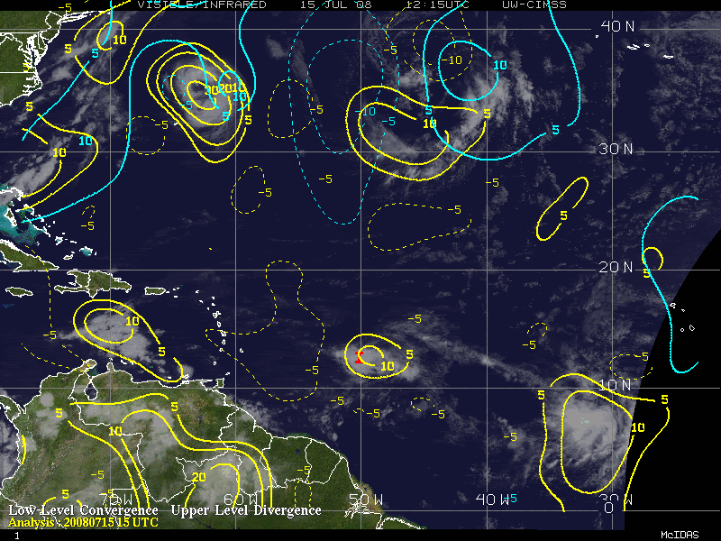
According to this image ( http://cimss.ssec.wisc.edu/tropic/real- ... g8dvg.html ), there is actually plenty of upper-level divergence. That being said, I still think the development chances of this system are quite low.O Town wrote:Yeah I am seeing the lower level convergence, but no divergence in the upper levels, you do need both.
Yellow is the converg. and blue the diverg. in the image below.
Heck Im seeing just as much convergence in the wave behind 94.
0 likes

Re: ATL: INVEST 94L East of the Windward Islands
I see a more defined LLC near 13N and 51W, moving westward. But the convection is weakening again. I still think is has low chance of development given the marginal enviornment.
0 likes
-
jaxfladude
- Category 5
- Posts: 1249
- Joined: Wed Aug 24, 2005 9:36 pm
- Location: Jacksonville, Fla
-
Blown Away

- S2K Supporter
- Posts: 10253
- Joined: Wed May 26, 2004 6:17 am
Re: ATL: INVEST 94L East of the Windward Islands

Last edited by Blown Away on Tue Jul 15, 2008 4:13 pm, edited 1 time in total.
0 likes


Who is online
Users browsing this forum: No registered users and 112 guests