Wave Coming Behind 94L

This is the general tropical discussion area. Anyone can take their shot at predicting a storms path.

Moderator: S2k Moderators

Forum rules

The posts in this forum are NOT official forecasts and should not be used as such. They are just the opinion of the poster and may or may not be backed by sound meteorological data. They are NOT endorsed by any professional institution or STORM2K. For official information, please refer to products from the National Hurricane Center and National Weather Service.

Help Support Storm2K
Message
Author
mattpetre
Category 2
Category 2
Posts: 510
Age: 53
Joined: Mon Sep 19, 2005 3:20 pm
Location: Missouri City,TX & Galleria
Contact:

Wave Coming Behind 94L

#1 Postby mattpetre » Sun Jul 13, 2008 6:12 pm

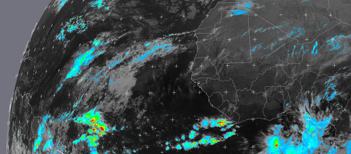
Looks to me that the latest wave off the African Coast is as strong or stronger than 94L was upon exit. Are the models latching onto it at all yet? It just looks to me to have the same basic signatures that Bertha and 94L had upon entering the Atlantic (all of the waves that just dissipated did so much more quickly than these or they stayed in the ITCZ.) Is this a candidate for development?
0 likes   

User avatar
Windtalker1
S2K Supporter
S2K Supporter
Posts: 523
Age: 37
Joined: Sun Jul 31, 2005 11:00 am
Location: Mesa, Arizona

Re: Wave Coming Behind 94L

#2 Postby Windtalker1 » Sun Jul 13, 2008 8:31 pm

Ha a spin to it already just off the coast. Maybe the next one to watch also.
0 likes   

tropicsPR
Tropical Depression
Tropical Depression
Posts: 79
Joined: Fri Aug 15, 2003 9:52 pm
Location: Puerto Rico

#3 Postby tropicsPR » Mon Jul 14, 2008 6:48 pm

Interesting activity behind Invest 94L. ¿ Next Invest ?

Image
0 likes   

RL3AO
Moderator-Pro Met
Moderator-Pro Met
Posts: 16308
Joined: Thu Jun 14, 2007 10:03 pm
Location: NC

#4 Postby RL3AO » Mon Jul 14, 2008 6:50 pm

Lets see if TPC/NHC sees a tropical wave with it when the TWD comes out in a few minutes.
0 likes   

Ed Mahmoud

Re: Wave Coming Behind 94L

#5 Postby Ed Mahmoud » Mon Jul 14, 2008 6:53 pm

Bastardi mentioned he thought the MJO phase might be favorable for one more African wave...
0 likes   

User avatar
KWT
Category 5
Category 5
Posts: 31415
Joined: Tue Aug 17, 2004 11:02 am
Location: UK!!!

#6 Postby KWT » Mon Jul 14, 2008 7:00 pm

Yep that area is interesting and its on the eastern side of the deep convective burst on the ITCZ so we will have to wait and see.

Ed, what worries me is the next really favorable MJO phase will probably come through late August time, bang in the heart of the season.
0 likes   

HurricaneHunter914
Category 5
Category 5
Posts: 4439
Age: 31
Joined: Fri Mar 10, 2006 7:36 pm
Location: College Station, TX

#7 Postby HurricaneHunter914 » Mon Jul 14, 2008 7:47 pm

Well, if 94L fails, the entire board will probably run to this thread. :lol:
Seriously, this is a nice looking system. Everything looks favorable for it now, so let's see what it does.
0 likes   

Patrick99
Category 5
Category 5
Posts: 1772
Joined: Mon May 24, 2004 3:43 pm
Location: SW Broward, FL

Re: Wave Coming Behind 94L

#8 Postby Patrick99 » Mon Jul 14, 2008 8:41 pm

It almost looks like it's gotten closer to 94L and stolen some of its thunder. Literally, I guess.
0 likes   

User avatar
cycloneye
Admin
Admin
Posts: 145813
Age: 68
Joined: Thu Oct 10, 2002 10:54 am
Location: San Juan, Puerto Rico

Re: Wave Coming Behind 94L

#9 Postby cycloneye » Mon Jul 14, 2008 9:31 pm

Image
0 likes   

User avatar
Extremeweatherguy
Category 5
Category 5
Posts: 11095
Joined: Mon Oct 10, 2005 8:13 pm
Location: Florida

#10 Postby Extremeweatherguy » Mon Jul 14, 2008 9:33 pm

Looks nice, but after being rudely tricked by 94L's seemingly fast development, I am not going to be getting too excited about this one until after it is named a tropical depression or better..
0 likes   

User avatar
boca
Category 5
Category 5
Posts: 6369
Age: 60
Joined: Mon Dec 15, 2003 8:49 am
Location: Boca Raton,FL

Re:

#11 Postby boca » Mon Jul 14, 2008 9:42 pm

HurricaneHunter914 wrote:Well, if 94L fails, the entire board will probably run to this thread. :lol:
Seriously, this is a nice looking system. Everything looks favorable for it now, so let's see what it does.


You are so right it predict this thread will have over 100 hits by morning.
0 likes   

User avatar
boca
Category 5
Category 5
Posts: 6369
Age: 60
Joined: Mon Dec 15, 2003 8:49 am
Location: Boca Raton,FL

Re: Wave Coming Behind 94L

#12 Postby boca » Mon Jul 14, 2008 9:44 pm

Paul is taking from Peter.Area at 8n and 28w is sucking 94L dry at the moment.
0 likes   

Squarethecircle
Category 5
Category 5
Posts: 2165
Joined: Fri Oct 19, 2007 4:00 pm
Location: Fairfax, VA

#13 Postby Squarethecircle » Mon Jul 14, 2008 9:46 pm

Sort of a blob-type situation here. I don't see much worth watching yet, but I guess it's still worth a look (the unexpected can and has been frequently known to happen).
0 likes   

TheRingo
Tropical Storm
Tropical Storm
Posts: 170
Joined: Sat Aug 26, 2006 4:46 pm

#14 Postby TheRingo » Mon Jul 14, 2008 10:13 pm

The MJO will be rolling out soon. This could be the last gasp until it makes it's way around again.

Image
0 likes   

mattpetre
Category 2
Category 2
Posts: 510
Age: 53
Joined: Mon Sep 19, 2005 3:20 pm
Location: Missouri City,TX & Galleria
Contact:

#15 Postby mattpetre » Mon Jul 14, 2008 10:39 pm

Would be a rather strange occurence if the blob of convection from this catches up with the naked swirl of 94L and from this a storm is born. Unprecedented in the Cape Verde train?

Is it just me or is this not an exceptionally active ITCZ?
0 likes   

User avatar
KWT
Category 5
Category 5
Posts: 31415
Joined: Tue Aug 17, 2004 11:02 am
Location: UK!!!

#16 Postby KWT » Tue Jul 15, 2008 4:12 am

big convective burst there on the ITCZ, interesting but whether or not it needs watching is another matter.
0 likes   

User avatar
alan1961
Category 2
Category 2
Posts: 771
Joined: Mon Mar 20, 2006 11:58 am
Location: Derby, Derbyshire, England
Contact:

Re: Wave Coming Behind 94L

#17 Postby alan1961 » Tue Jul 15, 2008 4:28 am

well at least we may have 2 to watch considering its only july, think we might have to get ready for Bertha's remnants KWT if the atlantic conveyor belt of gloom brings her this way :wink:
0 likes   

User avatar
Thunder44
Category 5
Category 5
Posts: 5922
Age: 44
Joined: Mon Jun 09, 2003 7:53 pm
Location: New York City

Re: Wave Coming Behind 94L

#18 Postby Thunder44 » Tue Jul 15, 2008 5:05 am

This wave is starting look better than 94L. Looks an broad or elongated area of low pressure on the QS this morning:


Image

http://manati.orbit.nesdis.noaa.gov/dat ... MBas26.png
0 likes   

User avatar
HURAKAN
Professional-Met
Professional-Met
Posts: 46086
Age: 38
Joined: Thu May 20, 2004 4:34 pm
Location: Key West, FL
Contact:

#19 Postby HURAKAN » Tue Jul 15, 2008 5:11 am

Image

Image
0 likes   

Matt-hurricanewatcher

Re: Wave Coming Behind 94L

#20 Postby Matt-hurricanewatcher » Tue Jul 15, 2008 5:15 am

Looks like a very sharp wave or maybe a LLC. I would say 95L later today.
0 likes   


Return to “Talkin' Tropics”

Who is online

Users browsing this forum: 7cardinal, Ian2401, StormWeather and 40 guests