ATL: Tropical Depression Dolly

Moderator: S2k Moderators

Message
Author
MiamiensisWx

Re:

#301 Postby MiamiensisWx » Sun Jul 13, 2008 7:10 pm

wx247 wrote:Evening everyone. I am following along and reading... not really posting too much. Thanks to everyone who is taking time to make substantive posts.

Quick thought/question... looks like the system may set up a little further north than the models are initializing it. Doesn't that kind of throw the model tracks we are seeing off in relation to impacts on the islands?

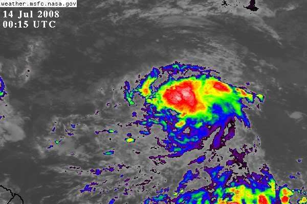
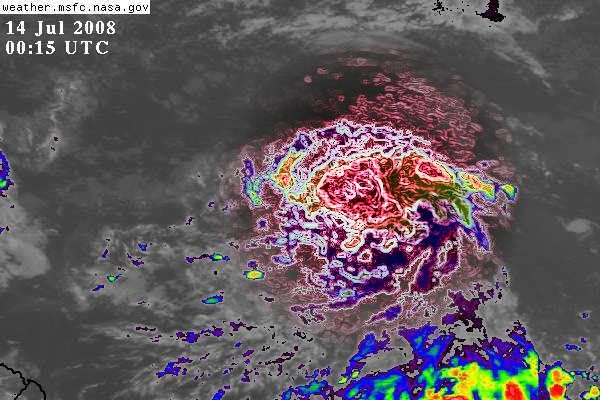
Nope; check my post:

http://www.storm2k.org/phpbb2/viewtopic.php?p=1735267#p1735267
0 likes   

User avatar
KWT
Category 5
Category 5
Posts: 31415
Joined: Tue Aug 17, 2004 11:02 am
Location: UK!!!

#302 Postby KWT » Sun Jul 13, 2008 7:11 pm

Yep Hurakan hardly surprisng given the wording of that TWO, couldn't be much more agressive then that.

Looks like the center is developing just to the south of the deep convection right now, close enough to help strengthen it.
0 likes   

Aric Dunn
Category 5
Category 5
Posts: 21238
Age: 42
Joined: Sun Sep 19, 2004 9:58 pm
Location: Ready for the Chase.
Contact:

#303 Postby Aric Dunn » Sun Jul 13, 2008 7:19 pm

not surprised at all with that TWO right in line for it to be a TD .. as i said this morning rapid orginization was likely...
0 likes   

Weatherfreak000

#304 Postby Weatherfreak000 » Sun Jul 13, 2008 7:21 pm

Future Cristobal has a much better chance at U.S. Landfall then Bertha ever had IMO. A storm having to traverse the entire Atlantic such as Bertha is always a good candidate for recurvature.

That said my previous post regarding Florida was semi-humorous. Florida gets black listed because of the sheer amount of people I disagree with and everyone knows that. I think we can definitely agree Florida and perhaps a path into the Gulf may possibly be a legitimate threat this time around given recent model runs but again it's too early.
0 likes   

Aric Dunn
Category 5
Category 5
Posts: 21238
Age: 42
Joined: Sun Sep 19, 2004 9:58 pm
Location: Ready for the Chase.
Contact:

Re: ATL: INVEST 94L East of the Windward Islands

#305 Postby Aric Dunn » Sun Jul 13, 2008 7:26 pm

well by chance the system is sitting right in between two buoys this evening one just the north(41026) and one just to the south (13009)
anyway the only surface data depicts a closed low as the northern buoy has a east wind and the southern has a west wind.. although not very symmetrical

41026
http://www.ndbc.noaa.gov/station_page.php?station=41026

13009
http://www.ndbc.noaa.gov/station_page.php?station=13009


Image
0 likes   

User avatar
kpost
Tropical Storm
Tropical Storm
Posts: 101
Age: 48
Joined: Sun Jul 06, 2008 10:52 am
Location: Indialantic, Florida (Ohio 4now)

Re: ATL: INVEST 94L East of the Windward Islands

#306 Postby kpost » Sun Jul 13, 2008 7:32 pm

can definitely see improvement

Image
0 likes   

User avatar
KWT
Category 5
Category 5
Posts: 31415
Joined: Tue Aug 17, 2004 11:02 am
Location: UK!!!

#307 Postby KWT » Sun Jul 13, 2008 7:36 pm

Quite possibly Aric, the thing is there is no reason why it won't develop fairly quickly as well once it does eventually gain a center.
0 likes   

User avatar
Chacor
Category 5
Category 5
Posts: 10229
Joined: Mon Oct 02, 2006 10:43 pm
Location: Singapore

#308 Postby Chacor » Sun Jul 13, 2008 7:37 pm

Why has that one disturbance seemingly split into two?
0 likes   

Mecklenburg

Re: ATL: INVEST 94L East of the Windward Islands

#309 Postby Mecklenburg » Sun Jul 13, 2008 7:42 pm

atlantic is waking up early this season... :eek:
0 likes   

User avatar
Cyclenall
Category 5
Category 5
Posts: 6666
Joined: Thu Jun 08, 2006 10:01 pm
Location: Ontario, Canada

#310 Postby Cyclenall » Sun Jul 13, 2008 7:43 pm

The following post is NOT an official forecast or product and should not be used as such. It is just the opinion of the poster and may or may not be backed by sound meteorological data. It is NOT endorsed by any professional institution including storm2k.org For Official Information please refer to the NHC and NWS products.


First % chance that Invest 94L will become a:

Tropical Depression: 95%
Tropical Storm: 90%
Hurricane: 70% (a bit early)
Category 2 Hurricane: 50%
Category 3,4, and 5 Hurricane: Unknown %

This is not from any program or scientific formula, this is just my thoughts alone on the %'s.

This is ramping up much more quickly then I thought it would. Everyone is bullish on the same system, something I haven't seen in a long time.
0 likes   

Sanibel
Category 5
Category 5
Posts: 10375
Joined: Mon Aug 30, 2004 11:06 pm
Location: Offshore SW Florida

Re: ATL: INVEST 94L East of the Windward Islands

#311 Postby Sanibel » Sun Jul 13, 2008 7:44 pm

Convection jumped up to the center near 12N-39W. Better form up there. Looks like a spinner. Still too early to tell for sure.
0 likes   

User avatar
drezee
S2K Supporter
S2K Supporter
Posts: 3664
Joined: Mon Jun 09, 2003 12:49 pm
Location: FL

Re: ATL: INVEST 94L East of the Windward Islands

#312 Postby drezee » Sun Jul 13, 2008 7:45 pm

I actually am not liking this one at all. I feel that it is heading to land...
0 likes   

User avatar
canegrl04
Category 5
Category 5
Posts: 2486
Joined: Thu Aug 26, 2004 5:37 pm
Location: Texas

Re: ATL: INVEST 94L East of the Windward Islands

#313 Postby canegrl04 » Sun Jul 13, 2008 7:46 pm

Mecklenburg wrote:atlantic is waking up early this season... :eek:


It will be very ominous to say the least if this become hurricane Cristobol and strikes the US.We haven't gotten to the heart of the season yet. I wonder how many JUly canes struck the US
0 likes   

weatherguru18

Re:

#314 Postby weatherguru18 » Sun Jul 13, 2008 7:48 pm

Weatherfreak000 wrote:Future Cristobal has a much better chance at U.S. Landfall then Bertha ever had IMO. A storm having to traverse the entire Atlantic such as Bertha is always a good candidate for recurvature.

That said my previous post regarding Florida was semi-humorous. Florida gets black listed because of the sheer amount of people I disagree with and everyone knows that. I think we can definitely agree Florida and perhaps a path into the Gulf may possibly be a legitimate threat this time around given recent model runs but again it's too early.


Yeah, but with a negitive NAO, recurvature is supposed to be less likely is it not?
0 likes   

MiamiensisWx

#315 Postby MiamiensisWx » Sun Jul 13, 2008 7:50 pm

This one could be a TD now, though classification will likely not occur until tomorrow. The next QuikSCAT pass will be very revealing.
0 likes   

User avatar
KWT
Category 5
Category 5
Posts: 31415
Joined: Tue Aug 17, 2004 11:02 am
Location: UK!!!

#316 Postby KWT » Sun Jul 13, 2008 7:51 pm

Agreed Dreeze one way or another I think this one is gonig to be a threat to land somewhere along the line its just a matter of where abouts I feel sadly.

Sanibel, seems like center is still to the south of the convection, to be expected given the center is still weak right now and for now as long as deep convection is somewhat near the center its a good sign for development.

Miami I agree but they will hold for a little while yet I feel, next 24hrs its looking likely though.
0 likes   

jusjas
Tropical Wave
Tropical Wave
Posts: 5
Joined: Sun Jul 13, 2008 7:52 pm

Re: ATL: INVEST 94L East of the Windward Islands

#317 Postby jusjas » Sun Jul 13, 2008 7:55 pm

Hi all,

I live in Trinidad - the most southerly isle of the Caribbean. Can I ask someone a question please? What is the chance of invest 94 hitting Trinidad? Thanks

Regards
jusjas
0 likes   

chadtm80

Re: ATL: INVEST 94L East of the Windward Islands

#318 Postby chadtm80 » Sun Jul 13, 2008 7:56 pm

Image

Image

Full Info - http://www.storm2k.org/weather/hw3.php? ... &year=2008

Invest94 Track (2008) view table

Date
(UTC) Position Pressure
mb (in) Winds
mph (kts)
Lat Lon

Code: Select all

Date   (UTC) Position Pressure  mb (in) Winds  mph (kts) Lat Lon
 Jul 13, 2008 1800 9.3N 38.2W 29.77 (1008) 29 (25)
Jul 13, 2008 1200 8.9N 37.2W 29.77 (1008) 29 (25)
Jul 13, 2008 0600 8.8N 36.6W 29.83 (1010) 23 (20)
Jul 13, 2008 0000 8.7N 36W 29.8 (1009) 23 (20)
Jul 12, 2008 1800 8.6N 35.6W 29.8 (1009) 23 (20)
Jul 12, 2008 1200 8.5N 35W 29.8 (1009) 23 (20)
Jul 12, 2008 0600 8.5N 34.2W 29.8 (1009) 23 (20
)
0 likes   

User avatar
orion
S2K Supporter
S2K Supporter
Posts: 165
Joined: Mon Aug 02, 2004 5:44 pm
Location: Indian Harbour Beach, FL
Contact:

Re:

#319 Postby orion » Sun Jul 13, 2008 7:57 pm

Chacor wrote:Why has that one disturbance seemingly split into two?


I noticed that too, Chacor... I think on the previous page. It was interesting to watch on the floater as it looked like it just pulled itself apart right about the time the convection was firing more on the northern part.
0 likes   

User avatar
HURAKAN
Professional-Met
Professional-Met
Posts: 46086
Age: 38
Joined: Thu May 20, 2004 4:34 pm
Location: Key West, FL
Contact:

#320 Postby HURAKAN » Sun Jul 13, 2008 7:57 pm

Image

Image
0 likes   


Return to “2008”

Who is online

Users browsing this forum: No registered users and 9 guests