
wx247, if it does set-up a little further north then it probably means a slight right adjustment to the model tracks but really not all that big deal yet until we have a definate center.
MGC, I agree I think the next 18-36hrs is the timeframe for this system to get upgraded IMO.
Delta, well its a big threat I think, early days lets see what it does over the next few days first in terms of track but agreed the GFDL track doesn't look great for the USA.
ATL: Tropical Depression Dolly
Moderator: S2k Moderators

Re: ATL: INVEST 94L East of the Windward Islands
deltadog03 wrote:12z GFDL and 18zGFDL very ominous looking path for a """potential""" US threat. I say that because you can see the weakness from bertha..(could go up and out from that) or you can see the ridge starting to build back east to close that gap..and well.....u know the rest.
Changedog, would you happen to have a link to the 18z GFDL? I am looking at the FSU site, but the 18z runs have not been posted yet.
0 likes
-
WeatherEmperor
- S2K Supporter

- Posts: 4806
- Age: 42
- Joined: Thu Sep 04, 2003 2:54 pm
- Location: South Florida
Re: ATL: INVEST 94L East of the Windward Islands
ekal wrote:deltadog03 wrote:12z GFDL and 18zGFDL very ominous looking path for a """potential""" US threat. I say that because you can see the weakness from bertha..(could go up and out from that) or you can see the ridge starting to build back east to close that gap..and well.....u know the rest.
Changedog, would you happen to have a link to the 18z GFDL? I am looking at the FSU site, but the 18z runs have not been posted yet.
Try this site:
http://my.sfwmd.gov/sfwmd/common/images ... plots.html
Click on storm 94 to see all the models including the GFDL
<RICKY>
0 likes
-
HURAKAN

- Professional-Met

- Posts: 46084
- Age: 39
- Joined: Thu May 20, 2004 4:34 pm
- Location: Key West, FL
- Contact:
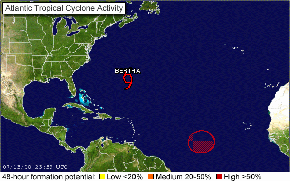
TROPICAL WEATHER OUTLOOK
NWS TPC/NATIONAL HURRICANE CENTER MIAMI FL
800 PM EDT SUN JUL 13 2008
FOR THE NORTH ATLANTIC...CARIBBEAN SEA AND THE GULF OF MEXICO...
THE TROPICAL WAVE AND BROAD AREA OF LOW PRESSURE LOCATED ABOUT 1500
MILES EAST OF THE SOUTHERN WINDWARD ISLANDS IS SHOWING SIGNS OF
ORGANIZATION. THIS SYSTEM COULD DEVELOP INTO A TROPICAL DEPRESSION
AT ANY TIME DURING THE NEXT DAY OR SO AS IT MOVES GENERALLY
WESTWARD AT 10 TO 15 MPH.
ELSEWHERE...TROPICAL CYCLONE FORMATION IS NOT EXPECTED DURING THE
NEXT 48 HOURS.
$$
FORECASTER BROWN/KNABB
0 likes
Re: ATL: INVEST 94L East of the Windward Islands
Ah, thanks. Do the intensity numbers come out later?
0 likes
-
HurricaneHunter914
- Category 5

- Posts: 4439
- Age: 32
- Joined: Fri Mar 10, 2006 7:36 pm
- Location: College Station, TX
-
PTrackerLA

- Category 5
- Posts: 5281
- Age: 42
- Joined: Thu Oct 10, 2002 8:40 pm
- Location: Lafayette, LA
Re: ATL: INVEST 94L East of the Windward Islands
Looks to be consolidating right now, I'd bet we'll have a TD by tomorrow. Gonna be a long season I'm afraid  .
.
0 likes
Thats a change in the wording there Hurakan, any time in the next day, so in other words it could form in 6hrs or 24hrs time, not quite the very bullish wording you sometimes get but its the next level step down from that it seem.
If it keeps this up we may well see TD3 tomorrow.
If it keeps this up we may well see TD3 tomorrow.
Last edited by KWT on Sun Jul 13, 2008 6:58 pm, edited 1 time in total.
0 likes
-
WeatherEmperor
- S2K Supporter
- Posts: 4806
- Age: 42
- Joined: Thu Sep 04, 2003 2:54 pm
- Location: South Florida
Re: ATL: INVEST 94L East of the Windward Islands
ekal wrote:Ah, thanks. Do the intensity numbers come out later?
Sorry I dont know. I am still trying to figure that one out. heh.
<RICKY>
0 likes

-
orion

- S2K Supporter
- Posts: 165
- Joined: Mon Aug 02, 2004 5:44 pm
- Location: Indian Harbour Beach, FL
- Contact:
Re: ATL: INVEST 94L East of the Windward Islands
I've been looking at the RGB Color IR loop on the floater and the convection building to the north (although have to wait until tomorrow when we get visible back now). I like the way the RGB Color IR lets you distinguish between the lower and upper clouds. I agree with what several of you have said and I am also thinking it is going to form north of where the models are initialized - looking at the AVN loop, it looks like the convection areas sorta split horizontally and pulled apart. The stronger area going north and then jumping over to the west and the weaker area moving south. The convection is still building nicely... just as I thought I was gonna get more sleep tonight.
0 likes
-
cycloneye

- Admin

- Posts: 149843
- Age: 69
- Joined: Thu Oct 10, 2002 10:54 am
- Location: San Juan, Puerto Rico
Re: ATL: INVEST 94L=8 PM EDT TWO.TD anytime
8 PM Discussion. Low is not in convection.
STRONG TROPICAL WAVE IS ALONG 38W/39W S OF 17N MOVING W 15 KT.
A 1008 MB LOW IS ANALYZED ALONG THE AXIS NEAR 9N. VISIBLE
SATELLITE IMAGES SHOWS A LARGE WELL DEFINED ENVELOPE OF CYCLONIC
TURNING...FOCUSED NEAR THE LOW CENTER. A LARGE AREA OF SCATTERED
MODERATE TO ISOLATED STRONG CONVECTION N OF THE LOW CENTER FROM
9N-13N BETWEEN 36W-41W. FURTHER S...WIDELY SCATTERED MODERATE
CONVECTION IS FROM EQ-5N BETWEEN 34W-40W. THIS SYSTEM HAS THE
POTENTIAL TO BECOMING A TROPICAL DEPRESSION DURING THE NEXT
COUPLE OF DAYS.
0 likes
-
kpost

- Tropical Storm

- Posts: 101
- Age: 49
- Joined: Sun Jul 06, 2008 10:52 am
- Location: Indialantic, Florida (Ohio 4now)
Re: ATL: INVEST 94L=8 PM EDT TWO.TD anytime
whats this mean? ATL: INVEST 94L=8 PM EDT TWO.TD anytime i checked the nhc 8 pm and didn't see it am i missing it?
0 likes
-
cycloneye
- Admin
- Posts: 149843
- Age: 69
- Joined: Thu Oct 10, 2002 10:54 am
- Location: San Juan, Puerto Rico
Re: ATL: INVEST 94L=8 PM EDT TWO.TD anytime
kpost wrote:whats this mean? ATL: INVEST 94L=8 PM EDT TWO.TD anytime i checked the nhc 8 pm and didn't see it am i missing it?
TROPICAL WEATHER OUTLOOK
NWS TPC/NATIONAL HURRICANE CENTER MIAMI FL
800 PM EDT SUN JUL 13 2008
FOR THE NORTH ATLANTIC...CARIBBEAN SEA AND THE GULF OF MEXICO...
THE TROPICAL WAVE AND BROAD AREA OF LOW PRESSURE LOCATED ABOUT 1500
MILES EAST OF THE SOUTHERN WINDWARD ISLANDS IS SHOWING SIGNS OF
ORGANIZATION. THIS SYSTEM COULD DEVELOP INTO A TROPICAL DEPRESSION
AT ANY TIME DURING THE NEXT DAY OR SO AS IT MOVES GENERALLY
WESTWARD AT 10 TO 15 MPH.
ELSEWHERE...TROPICAL CYCLONE FORMATION IS NOT EXPECTED DURING THE
NEXT 48 HOURS.
$$
FORECASTER BROWN/KNABB
0 likes
-
vacanechaser

- Category 5
- Posts: 1461
- Joined: Wed Dec 03, 2003 9:34 pm
- Location: Portsmouth, Va
- Contact:
000
ABNT20 KNHC 132352
TWOAT
TROPICAL WEATHER OUTLOOK
NWS TPC/NATIONAL HURRICANE CENTER MIAMI FL
800 PM EDT SUN JUL 13 2008
FOR THE NORTH ATLANTIC...CARIBBEAN SEA AND THE GULF OF MEXICO...
THE NATIONAL HURRICANE CENTER IS ISSUING ADVISORIES ON TROPICAL
STORM BERTHA...LOCATED ABOUT 170 MILES SOUTHEAST OF BERMUDA.
THE TROPICAL WAVE AND BROAD AREA OF LOW PRESSURE LOCATED ABOUT 1500
MILES EAST OF THE SOUTHERN WINDWARD ISLANDS IS SHOWING SIGNS OF
ORGANIZATION. THIS SYSTEM COULD DEVELOP INTO A TROPICAL DEPRESSION
AT ANY TIME DURING THE NEXT DAY OR SO AS IT MOVES GENERALLY
WESTWARD AT 10 TO 15 MPH.
ELSEWHERE...TROPICAL CYCLONE FORMATION IS NOT EXPECTED DURING THE
NEXT 48 HOURS.
$$
FORECASTER BROWN/KNABB
Jesse V. Bass III
http://www.vastormphoto.com
Hurricane Intercept Research Team
0 likes
-
kpost
- Tropical Storm
- Posts: 101
- Age: 49
- Joined: Sun Jul 06, 2008 10:52 am
- Location: Indialantic, Florida (Ohio 4now)
Re: ATL: INVEST 94L=8 PM EDT TWO.TD anytime
ok thanks i had only saw this one
"STRONG TROPICAL WAVE IS ALONG 38W/39W S OF 17N MOVING W 15 KT.
A 1008 MB LOW IS ANALYZED ALONG THE AXIS NEAR 9N. VISIBLE
SATELLITE IMAGES SHOWS A LARGE WELL DEFINED ENVELOPE OF CYCLONIC
TURNING...FOCUSED NEAR THE LOW CENTER. A LARGE AREA OF SCATTERED
MODERATE TO ISOLATED STRONG CONVECTION N OF THE LOW CENTER FROM
9N-13N BETWEEN 36W-41W. FURTHER S...WIDELY SCATTERED MODERATE
CONVECTION IS FROM EQ-5N BETWEEN 34W-40W. THIS SYSTEM HAS THE
POTENTIAL TO BECOMING A TROPICAL DEPRESSION DURING THE NEXT
COUPLE OF DAYS."
Last edited by kpost on Sun Jul 13, 2008 7:06 pm, edited 1 time in total.
0 likes

Re: ATL: INVEST 94L East of the Windward Islands
ekal wrote:deltadog03 wrote:12z GFDL and 18zGFDL very ominous looking path for a """potential""" US threat. I say that because you can see the weakness from bertha..(could go up and out from that) or you can see the ridge starting to build back east to close that gap..and well.....u know the rest.
Changedog, would you happen to have a link to the 18z GFDL? I am looking at the FSU site, but the 18z runs have not been posted yet.
Try this link to see it in animation:
http://moe.met.fsu.edu/cgi-bin/gfstc2.c ... =Animation
0 likes
Who is online
Users browsing this forum: No registered users and 44 guests