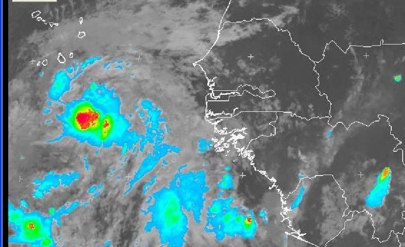
TC Bertha

Moderator: S2k Moderators

Message
Author
CrazyC83
Professional-Met
Professional-Met
Posts: 34002
Joined: Tue Mar 07, 2006 11:57 pm
Location: Deep South, for the first time!

Re: Re:

#601 Postby CrazyC83 » Wed Jul 02, 2008 9:46 pm

brunota2003 wrote:
Matt-hurricanewatcher wrote:
MGC wrote:92L needs a lot more convection than that lone thunderstorm to be upgraded. 93L has more convection this evening than 92L. 92L has a excellent circulation based on QS but until substantial convection develops near the circulation center there will be not upgrade IMO....MGC


I understand that this is no where, but I'm a strong supporter and believer in one standard for the whole Atlantic, I will keep on fighting for it.

The only problem is, we do not have recon for the entire Atlantic, either. If it was off Florida, we'd have Recon in it all the time.


Yeah, we'd need help from everyone to fund such (or a private organization) since it would have to be based out of Cape Verde to catch the deepest tropics.
0 likes   

User avatar
cycloneye
Admin
Admin
Posts: 145330
Age: 68
Joined: Thu Oct 10, 2002 10:54 am
Location: San Juan, Puerto Rico

Re: INVEST 92L in the Eastern Atlantic

#602 Postby cycloneye » Wed Jul 02, 2008 9:49 pm

I agree totally, if this can get going, then this could be something to watch. It will likely recurve, but it maybe our first long "tracker" like storm like Alberto 2000. I'm not saying as long track of course!. Also, I strongly agree that the system is far stronger then 93L ever hopes to be. It has a well defined LLC with 30-35 knot winds.


And the ACE will start to rise in the Atlantic.But lets not get ahead of ourselves as there is not a cyclone yet.
0 likes   

User avatar
NDG
S2K Supporter
S2K Supporter
Posts: 15446
Joined: Sun Jul 09, 2006 10:14 pm
Location: Orlando, FL

#603 Postby NDG » Wed Jul 02, 2008 9:53 pm

Who says convection is dying out, this is as of 55 minutes ago
Image
0 likes   

User avatar
Normandy
Category 5
Category 5
Posts: 2293
Joined: Sun Oct 10, 2004 12:31 am
Location: Houston, TX

#604 Postby Normandy » Wed Jul 02, 2008 10:01 pm

Image

I mean honestly it does fit every parameter that the NHC uses to classify a tropical depression (IE if it were in the gulf it would be classified). But i see why they are waiting for persistence.
0 likes   

User avatar
MGC
S2K Supporter
S2K Supporter
Posts: 5899
Joined: Sun Mar 23, 2003 9:05 pm
Location: Pass Christian MS, or what is left.

Re: INVEST 92L in the Eastern Atlantic

#605 Postby MGC » Wed Jul 02, 2008 10:02 pm

93L has little chance to become a TC any time soon. Yes, 92L has a better shot but not for a while unless there is a big pulse of convection. 92L has climo going against it and that says a lot. If 92L has a blowup of convection tonight than it might get upgraded. Of course I've seen stranger things in my 40+ years of tracking tropical cyclones......MGC
0 likes   

User avatar
NDG
S2K Supporter
S2K Supporter
Posts: 15446
Joined: Sun Jul 09, 2006 10:14 pm
Location: Orlando, FL

#606 Postby NDG » Wed Jul 02, 2008 10:03 pm

30 minutes ago, I would be surprised that it is not upgraded by morning at the latest.
Image
0 likes   

soonertwister
Category 5
Category 5
Posts: 1091
Joined: Mon Jun 16, 2003 2:52 pm

Re: INVEST 92L in the Eastern Atlantic

#607 Postby soonertwister » Wed Jul 02, 2008 10:05 pm

The force in this one is strong, grasshoppers. Look at the amazing amount of convection that's being sucked in from the ITCZ. Click on the image to see the high-resolution image. Still major convection over the LLC with cloudtops colder than -80C.

http://www.nrlmry.navy.mil/tc-bin/tc_ho ... m&TYPE=geo

It's likely that this link will self-destruct in a while. That's OK with me.
0 likes   

RL3AO
Moderator-Pro Met
Moderator-Pro Met
Posts: 16308
Joined: Thu Jun 14, 2007 10:03 pm
Location: NC

#608 Postby RL3AO » Wed Jul 02, 2008 10:05 pm

By the technical definition, thats a tropical depression...or storm.
0 likes   

User avatar
ekal
Tropical Storm
Tropical Storm
Posts: 210
Age: 36
Joined: Thu Aug 25, 2005 11:13 am
Location: Miami, Florida

Re: INVEST 92L in the Eastern Atlantic

#609 Postby ekal » Wed Jul 02, 2008 10:06 pm

:uarrow: That is an impressive burst of convection. Where can I find that satellite image/loop, NDG?
0 likes   

User avatar
NDG
S2K Supporter
S2K Supporter
Posts: 15446
Joined: Sun Jul 09, 2006 10:14 pm
Location: Orlando, FL

#610 Postby NDG » Wed Jul 02, 2008 10:08 pm

0 likes   

Aric Dunn
Category 5
Category 5
Posts: 21238
Age: 42
Joined: Sun Sep 19, 2004 9:58 pm
Location: Ready for the Chase.
Contact:

#611 Postby Aric Dunn » Wed Jul 02, 2008 10:10 pm

loop ... http://oiswww.eumetsat.org/SDDI/cgi/lis ... v=400,pp=0


the interesting part is the refiring .. of convection .. over the center..

the western part of the convection is building south while the eastern part is building north meaning convection may be trying to wrap around rather than just a burst here and there.,.
but will see

this next burst that is starting looks to bigger than the previous and in more than one quadrant..
Last edited by Aric Dunn on Wed Jul 02, 2008 10:12 pm, edited 1 time in total.
0 likes   

User avatar
ekal
Tropical Storm
Tropical Storm
Posts: 210
Age: 36
Joined: Thu Aug 25, 2005 11:13 am
Location: Miami, Florida

Re:

#612 Postby ekal » Wed Jul 02, 2008 10:11 pm

0 likes   

User avatar
windycity
S2K Supporter
S2K Supporter
Posts: 461
Joined: Wed Aug 24, 2005 6:45 pm
Location: P.B.county,Fl.
Contact:

Re: INVEST 92L in the Eastern Atlantic

#613 Postby windycity » Wed Jul 02, 2008 10:20 pm

Beautiful sat pics sooner!! " She" really is impressive, isn't she? :lol:
0 likes   

MiamiensisWx

Re: INVEST 92L in the Eastern Atlantic

#614 Postby MiamiensisWx » Wed Jul 02, 2008 10:23 pm

windycity wrote:Beautiful sat pics sooner!! " She" really is impressive, isn't she?

"It" is impressive. I know your post was entirely in jest, but this one hasn't even been classified as a named TC.
Last edited by MiamiensisWx on Wed Jul 02, 2008 10:24 pm, edited 1 time in total.
0 likes   

soonertwister
Category 5
Category 5
Posts: 1091
Joined: Mon Jun 16, 2003 2:52 pm

Re: INVEST 92L in the Eastern Atlantic

#615 Postby soonertwister » Wed Jul 02, 2008 10:24 pm

windycity wrote:Beautiful sat pics sooner!! " She" really is impressive, isn't she? :lol:


More beatiful than any I've ever seen before under the Cape Verdes, that's for sure. The image link should expire soon if not already, but if you go the the link I posted on page 23, navigate from the left column to 92L, and select GEO from the IR column on the right side of the subsequent page, you can see the latest image.

Boy do I LOVE geostationary satellites!
Last edited by soonertwister on Wed Jul 02, 2008 10:25 pm, edited 1 time in total.
0 likes   

User avatar
wxman57
Moderator-Pro Met
Moderator-Pro Met
Posts: 22979
Age: 67
Joined: Sat Jun 21, 2003 8:06 pm
Location: Houston, TX (southwest)

Re: INVEST 92L in the Eastern Atlantic

#616 Postby wxman57 » Wed Jul 02, 2008 10:24 pm

One thing I'd caution you all about is making assumptions where the center of a weak low is using IR imagery. It's just impossible to tell if the LLC is beneath or near any convection at night. I'm sure that the NHC is using extrapolation from the last visible fix and perhaps a little assuming that it may be near that convection, but we can't know for sure until we can see the low cloud motions after sunrise. I've seen so many weak disturbances that look great at night on IR imagery only to find out the center was 50 or 100 or more miles from the convection all along once the sun comes up.

So since there is so much uncertainty, and since this system is not going to be threatening anyone soon, the NHC can just watch it for a day or two to see if it holds together before calling it a TD. If it was in the NW Gulf would they call it a TD? Probably. But that would be because it's a potential threat to someone in the NW Gulf and there is a need for issuing advisories to keep everyone informed of the potential threat. You may say that it makes no sense to have a double standard, but that's the way it is.

Time for bed.
0 likes   

soonertwister
Category 5
Category 5
Posts: 1091
Joined: Mon Jun 16, 2003 2:52 pm

Re: INVEST 92L in the Eastern Atlantic

#617 Postby soonertwister » Wed Jul 02, 2008 10:27 pm

wxman57 wrote:One thing I'd caution you all about is making assumptions where the center of a weak low is using IR imagery. It's just impossible to tell if the LLC is beneath or near any convection at night. I'm sure that the NHC is using extrapolation from the last visible fix and perhaps a little assuming that it may be near that convection, but we can't know for sure until we can see the low cloud motions after sunrise. I've seen so many weak disturbances that look great at night on IR imagery only to find out the center was 50 or 100 or more miles from the convection all along once the sun comes up.

So since there is so much uncertainty, and since this system is not going to be threatening anyone soon, the NHC can just watch it for a day or two to see if it holds together before calling it a TD. If it was in the NW Gulf would they call it a TD? Probably. But that would be because it's a potential threat to someone in the NW Gulf and there is a need for issuing advisories to keep everyone informed of the potential threat. You may say that it makes no sense to have a double standard, but that's the way it is.

Time for bed.


I took my position estimate from SSD, and IR image from NRL.
0 likes   

User avatar
wxman57
Moderator-Pro Met
Moderator-Pro Met
Posts: 22979
Age: 67
Joined: Sat Jun 21, 2003 8:06 pm
Location: Houston, TX (southwest)

Re: INVEST 92L in the Eastern Atlantic

#618 Postby wxman57 » Wed Jul 02, 2008 10:36 pm

soonertwister wrote:


I took my position estimate from SSD, and IR image from NRL.[/quote]

Doesn't make any difference. Without solid data like visible satellite imagery to see the low clouds or a network of surface observations we're all guessing where the center is. I can't tell where it is and I've been doing this for 30 years. IR imagery, particularly when there's a lot of cirrus clouds aloft, just won't show the low clouds well, so we have to make an educated guess as to where the center might be. Can't be sure until sunrise.
0 likes   

User avatar
HURAKAN
Professional-Met
Professional-Met
Posts: 46086
Age: 38
Joined: Thu May 20, 2004 4:34 pm
Location: Key West, FL
Contact:

#619 Postby HURAKAN » Wed Jul 02, 2008 10:37 pm

See you in 6 hours and 20 minutes. It should be interesting tomorrow morning.
0 likes   

User avatar
NDG
S2K Supporter
S2K Supporter
Posts: 15446
Joined: Sun Jul 09, 2006 10:14 pm
Location: Orlando, FL

#620 Postby NDG » Wed Jul 02, 2008 10:44 pm

Come on now, there is no way the NHC will sit around for a day or two if this system to upgrade this if is getting better organized: is developing deep convection near the center, no windshear, over warm waters, no dry air intruding the system, all the signs for it to keep gaining organization. If convection persists through at least 5 AM EDT, it could be upgraded.

By the way, they have enough evidence that it has a LLC.
0 likes   


Return to “2008”

Who is online

Users browsing this forum: No registered users and 4 guests