
Wxman57 what about the new area of convection that has gone up on the eastern side over the past 2hrs?
Have to admit it is a little lacking in any deep convection right now though thats for sure and also I do agree that center fix would fit far better with the way the system has curved as well.
as for development if it doesn't do anything soon then it may not develop for a while but note that SST's rise again once you get past 40W and IMO this is where the development is most likely to occur, if it gets anything before then its a bonus IMO.
TC Bertha
Moderator: S2k Moderators

-
Category 5

- Category 5

- Posts: 10074
- Age: 36
- Joined: Sun Feb 11, 2007 10:00 pm
- Location: New Brunswick, NJ
- Contact:
Re: INVEST 92L in the Eastern Atlantic
simeon9benjamin wrote:The weather channel started out at the top of the hour talking about this system off of Africa developing into a TD. This system is becoming more popular by the day.

Perhaps you should start a fan club.
0 likes
Hmmm its not bad looking at all but it has waned its convection since about 12hrs ago, though we are slowly heading towards the D-min over at this latitude which probably isn't helping and the lower heat content its moving towards is helping to prevent any really deep convection in the main.
Still think its going to habe to wait till 40W to do anything other then what its doing now IMO.
Still think its going to habe to wait till 40W to do anything other then what its doing now IMO.
0 likes
-
cycloneye

- Admin

- Posts: 149840
- Age: 69
- Joined: Thu Oct 10, 2002 10:54 am
- Location: San Juan, Puerto Rico
Re: INVEST 92L in the Eastern Atlantic
Very good looking 92L.And look at the extreme left that tiny circulation near Barbados.Information about that one at talking tropics forum.

0 likes

-
HURAKAN

- Professional-Met

- Posts: 46084
- Age: 39
- Joined: Thu May 20, 2004 4:34 pm
- Location: Key West, FL
- Contact:
Loop: http://rammb.cira.colostate.edu/product ... 010900.GIF
It may be just an illusion of my eyes (brain for that matter since it's the processing center) but the new convection seems to be developing over the LLC.
It may be just an illusion of my eyes (brain for that matter since it's the processing center) but the new convection seems to be developing over the LLC.
0 likes
Hmm it looks ok cycloneye but it looked better about 12hrs to be honest. Still its very good for the time of year it has to be said and thats what really counts I suppose, we shouldn't expect anything to form from this region at this time of year!
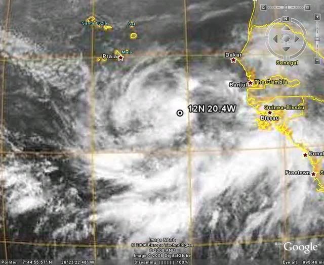
Chacor, so its estimated to have winds at 25kts, good stuff and note the center placement at 20.4, a good deal east of wxman57's estimate
Chacor, so its estimated to have winds at 25kts, good stuff and note the center placement at 20.4, a good deal east of wxman57's estimate
0 likes


Re: INVEST 92L in the Eastern Atlantic
gatorcane wrote:wxman57 wrote:I wouldn't put too much stock in the QuikSCAT pass position as that satellite had a hard time finding Katrina's center when it was a Cat 5 in the Gulf. I'm estimating the center close to 12N/23W as of 11Z. It's definitely accelerating. Past 24hr movement 360nm, previous 24hr movement only 280nm. Up to 15kts now. As it accelerates, the circulation is becoming elongated SW-NE a bit and convection is decreasing. I'm encouraged by the acceleration and the elongating of the center, as well as the decreasing convection. SSTs in advance of the low are now lower, so that's another good sign for no development. If it continues to accelerate today and if the convection doesn't return then it's chances of development are going to drop significantly.
Still, there's that "vacation factor" as I've been planning a day off tomorrow to get my car serviced.
So far the system has been behaving as I have expected with a gradual loss of convection as it moves away from the above normal SSTs just off the coast of Africa. Its even closer now to going poof in the next 48 hours or so with nothing but a remnant swirl with an occasional small burst near the "center". Look how the SSTs drop ahead of the system. It would have to move virtually WSW to stay in warm enough SSTs. Movement is West at the moment. Slow development if any is expected.

By the way it has been moving the past 12 hours or more, which is almost straight west it should stay near 80 deg SST until it gets to the 30 deg W Long. After that it drops below 80, but any significant gain in lat after that, it could surely move into much cooler waters, which is why I am not paying attention to those models that keep it getting stronger after that, but for the short term, next 24-48hrs, it still has a shot, IMO.
0 likes
Re:
KWT wrote:Indeed NDG though the ECM is interesting in that it does weaken the system as does the GFDL once it reaches the cooler waters. As I've said before past 40W both historical odds as well as the SST's start to rise again.
Even more past 50W
0 likes
-
wxman57

- Moderator-Pro Met

- Posts: 23177
- Age: 68
- Joined: Sat Jun 21, 2003 8:06 pm
- Location: Houston, TX (southwest)
Re:
KWT wrote:Wxman57 what about the new area of convection that has gone up on the eastern side over the past 2hrs?... snip
Note that the convection well east of the center is moving toward the NE - away from the center. The center is well west of that burst of convection and the storms aren't flowing toward the center. Definitely looking less organized by the hour.
0 likes
Indeed Chacor that does argue against this becoming a hurricane but then again we probably only have good solid data for that far east in the Atlantic for probably 30-40 years, before then it may well be the case that there were stronger systems that have been missed.
NDG, yep of course the question is according to the models right now will it even get that far west before moving off to the NW?
Hurakan, if thats the center then its right underneath that small area of deep convection.
Wxmna57...the center is being placed at 20.4W so I take it you strongly disagree with that?
0 likes
-
wxman57
- Moderator-Pro Met
- Posts: 23177
- Age: 68
- Joined: Sat Jun 21, 2003 8:06 pm
- Location: Houston, TX (southwest)
Re:
KWT wrote:Indeed Chacor that does argue against this becoming a hurricane but then again we probably only have good solid data for that far east in the Atlantic for probably 30-40 years, before then it may well be the case that there were stronger systems that have been missed.
NDG, yep of course the question is according to the models right now will it even get that far west before moving off to the NW?
Hurakan, if thats the center then its right underneath that small area of deep convection.
Wxmna57...the center is being placed at 20.4W so I take it you strongly disagree with that?
Looks like the circulation I was following was in the mid levels. It's being ripped apart as it accelerates westward. There does appear to be a weak LLC farther east near 20-21W. But the system as a whole is looking less organized now.
0 likes
-
Ed Mahmoud
Re: Re:
wxman57 wrote:KWT wrote:Wxman57 what about the new area of convection that has gone up on the eastern side over the past 2hrs?... snip
Note that the convection well east of the center is moving toward the NE - away from the center. The center is well west of that burst of convection and the storms aren't flowing toward the center. Definitely looking less organized by the hour.
That is a bad thing, in my humble unprofessional opinion, (IMHUP), as quick development means a quick recurve, whereas no development for a few days means it could form close enough to have a reduced chance to find an escape route.
0 likes
Who is online
Users browsing this forum: No registered users and 62 guests