TC Bertha
Moderator: S2k Moderators

-
littlevince

- S2K Supporter

- Posts: 768
- Joined: Fri Oct 21, 2005 10:45 am
- Location: Portugal

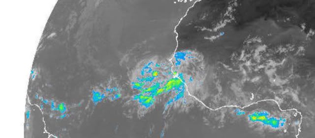
Ok thats impressive I have to admit, you can't miss the curveature it has right now. Convection a little on the shallow side on the northern section as to be expected with slightly lower heat content further north but its got a great shape, I think we will see a code red within the next 18hrs...
0 likes
-
Gustywind

- Category 5

- Posts: 12334
- Joined: Mon Sep 03, 2007 7:29 am
- Location: Baie-Mahault, GUADELOUPE
000
AXNT20 KNHC 021053
TWDAT
TROPICAL WEATHER DISCUSSION
NWS TPC/NATIONAL HURRICANE CENTER MIAMI FL
805 AM EDT WED JUL 02 2008
TROPICAL WEATHER DISCUSSION FOR NORTH AMERICA...CENTRAL
AMERICA...GULF OF MEXICO...CARIBBEAN SEA...NORTHERN SECTIONS OF
SOUTH AMERICA...AND ATLANTIC OCEAN TO THE AFRICAN COAST FROM THE
EQUATOR TO 32N. THE FOLLOWING INFORMATION IS BASED ON SATELLITE
IMAGERY...METEOROLOGICAL ANALYSIS...WEATHER OBSERVATIONS...AND
RADAR.
BASED ON 0600 UTC SURFACE ANALYSIS AND SATELLITE IMAGERY THROUGH
1015 UTC.
...SPECIAL FEATURE....
A STRONG TROPICAL WAVE IS OVER THE FAR E ATLANTIC NEARING THE
CAPE VERDE ISLANDS ALONG 21W S OF 19N MOVING W 10-15 KT. VISIBLE
IMAGERY REVEALS AN IMPRESSIVE CLOUD STRUCTURE WITH WELL DEFINED
MID-LEVEL TURNING ALONG THE WAVE AXIS NEAR 12N. HOWEVER...A 0714
UTC QSCAT PASS SUGGESTED THAT THE SFC CIRCULATION IS SITUATED
FARTHER E. WHILE CONVECTION HAS DECREASED SLIGHTLY...WITHIN 60
NM E AND 180 NM W OF THE WAVE AXIS S OF 15N...THIS SYSTEM HAS
GRADUALLY BECOME BETTER ORGANIZED AND THERE IS THE POTENTIAL FOR
IT TO BECOME A TROPICAL DEPRESSION OVER THE NEXT COUPLE OF DAYS.
0 likes
-
cycloneye

- Admin

- Posts: 149840
- Age: 69
- Joined: Thu Oct 10, 2002 10:54 am
- Location: San Juan, Puerto Rico
Re: INVEST 92L in the Eastern Atlantic
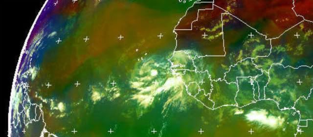
This QuickScat pass was around four hours ago.You can see clearly the circulation (Just below 12.0n) and also the strong winds in the form of black,yellow,pink and red barbs,prertty strong winds out there.

0 likes
-
Hyperstorm

- Category 5
- Posts: 1500
- Joined: Sun Sep 07, 2003 3:48 am
- Location: Ocala, FL
Re: INVEST 92L in the Eastern Atlantic
I think that development into a tropical depression today is looking less likely.
Latest satellite images reveal a good structure for a system at this location this time of the year, however the circulation (per latest quickscat data) is located to the east of the relatively shallow convection and it's moisture source is being robbed from the convective system to the NE of 92L that is trying to merge with it.
I think that the circulation will merge with the system coming off the coast right now and development after this should be relatively slow. Usually when we see a merger of systems it takes a couple of days before it congeals and forms a tight LLC capable of increasing deep convection. Remember that the GFS and other models have shown a low pressure center in this area and moving it to the WNW and we have that circulation right now, but that doesn't mean that it is a tropical cyclone. It could very well be (what they're seeing) is a huge circulation traversing the Atlantic. If it wasn't for this possible merger of systems, I'm sure the system would have probably developed quicker becoming a tropical depression today and weak tropical storm soon after that.
Today will be interesting to see how the merger helps or slows the development of this system...
0 likes
-
Gustywind
- Category 5
- Posts: 12334
- Joined: Mon Sep 03, 2007 7:29 am
- Location: Baie-Mahault, GUADELOUPE
http://cimss.ssec.wisc.edu/tropic/real- ... 8split.jpg
SAL is fairly improving, on the area, whereas some pockets are staying well ahead of the wave, but not as strong compared to the previous days, and these one are not so virulent in my opinion. Once again it could be a window of opportunity for this strong wave...Time to move west, time for the SAL be swept....time will tell!
SAL is fairly improving, on the area, whereas some pockets are staying well ahead of the wave, but not as strong compared to the previous days, and these one are not so virulent in my opinion. Once again it could be a window of opportunity for this strong wave...Time to move west, time for the SAL be swept....time will tell!
0 likes
The convection overland is surely just the normal convection that blows up overland, once it gets over water it will decay and leave this system alone I'd have thought. Also I doubt the models are just seeing one huge circulation, given a lot of the models take this down to at least 1004mbs if not lower.
Saying all that I think that the LLC is a little detached now as you'd expect and there is some shear on it ( look at the southern convection to really see it) but for a wave at this time of year it looks mighty impressive.
Saying all that I think that the LLC is a little detached now as you'd expect and there is some shear on it ( look at the southern convection to really see it) but for a wave at this time of year it looks mighty impressive.
0 likes


-
Hyperstorm
- Category 5
- Posts: 1500
- Joined: Sun Sep 07, 2003 3:48 am
- Location: Ocala, FL
Re:
KWT wrote:The convection overland is surely just the normal convection that blows up overland, once it gets over water it will decay and leave this system alone I'd have thought.
Normally that's the case, but seeing how the circulation is located east of the convection and a band of moisture to the south becoming entangled and stretching toward the system exiting the coast now, gives credence to the posibility of a merger and slower development than if it had stayed separate. As Hurakan mentioned, the system is moving very slow in that area, which I remember the GFS hinting at it by taking its sweet time moving the system W-WNW. Also, now that I think of it the GFS DID show what appeared to be two systems wobbling together and merging.
KWT wrote:Also I doubt the models are just seeing one huge circulation, given a lot of the models take this down to at least 1004mbs if not lower.
I also doubt it's just a circulation, but with the possible merger of systems it looks possible. I've seen that in the past where an impressive big tropical wave with circulation pulls toward cooler waters and never develops as it can't congeal without deep warm waters.
0 likes
-
cycloneye
- Admin
- Posts: 149840
- Age: 69
- Joined: Thu Oct 10, 2002 10:54 am
- Location: San Juan, Puerto Rico
Re: INVEST 92L in the Eastern Atlantic
ABNT20 KNHC 021143
TWOAT
TROPICAL WEATHER OUTLOOK
NWS TPC/NATIONAL HURRICANE CENTER MIAMI FL
800 AM EDT WED JUL 2 2008
FOR THE NORTH ATLANTIC...CARIBBEAN SEA AND THE GULF OF MEXICO...
THE WELL-DEFINED TROPICAL WAVE IN THE FAR EASTERN ATLANTIC...ABOUT
300 MILES SOUTHEAST OF THE CAPE VERDE ISLANDS...HAS NOT BECOME ANY
BETTER ORGANIZED THIS MORNING AS IT CONTINUES WESTWARD AT ABOUT 15
MPH. HOWEVER...ENVIRONMENTAL CONDITIONS APPEAR FAVORABLE FOR SOME
ADDITIONAL DEVELOPMENT...AND THIS SYSTEM HAS THE POTENTIAL TO
BECOME A TROPICAL DEPRESSION OVER THE NEXT COUPLE OF DAYS.
ELSEWHERE...TROPICAL CYCLONE FORMATION IS NOT EXPECTED DURING THE
NEXT 48 HOURS.
$$
FORECASTER FRANKLIN
0 likes
Possibly Hyperstorm, tohugh for now this is just one system with lots of baggage from Africa still present. It is interesting and may well eventually end up getting dragged into the general circulation of this system but that won't stop development if convection can form closer to the center like Hurakan's image shows may be starting to occur at least to some degree.
0 likes
-
wxman57

- Moderator-Pro Met

- Posts: 23177
- Age: 68
- Joined: Sat Jun 21, 2003 8:06 pm
- Location: Houston, TX (southwest)
Re: INVEST 92L in the Eastern Atlantic
I wouldn't put too much stock in the QuikSCAT pass position as that satellite had a hard time finding Katrina's center when it was a Cat 5 in the Gulf. I'm estimating the center close to 12N/23W as of 11Z. It's definitely accelerating. Past 24hr movement 360nm, previous 24hr movement only 280nm. Up to 15kts now. As it accelerates, the circulation is becoming elongated SW-NE a bit and convection is decreasing. I'm encouraged by the acceleration and the elongating of the center, as well as the decreasing convection. SSTs in advance of the low are now lower, so that's another good sign for no development. If it continues to accelerate today and if the convection doesn't return then it's chances of development are going to drop significantly.
Still, there's that "vacation factor" as I've been planning a day off tomorrow to get my car serviced.
Still, there's that "vacation factor" as I've been planning a day off tomorrow to get my car serviced.
0 likes
-
Eyewall
Re: INVEST 92L in the Eastern Atlantic
The weather channel started out at the top of the hour talking about this system off of Africa developing into a TD. This system is becoming more popular by the day. 
0 likes
-
gatorcane

- S2K Supporter
- Posts: 23708
- Age: 48
- Joined: Sun Mar 13, 2005 3:54 pm
- Location: Boca Raton, FL
Re: INVEST 92L in the Eastern Atlantic
wxman57 wrote:I wouldn't put too much stock in the QuikSCAT pass position as that satellite had a hard time finding Katrina's center when it was a Cat 5 in the Gulf. I'm estimating the center close to 12N/23W as of 11Z. It's definitely accelerating. Past 24hr movement 360nm, previous 24hr movement only 280nm. Up to 15kts now. As it accelerates, the circulation is becoming elongated SW-NE a bit and convection is decreasing. I'm encouraged by the acceleration and the elongating of the center, as well as the decreasing convection. SSTs in advance of the low are now lower, so that's another good sign for no development. If it continues to accelerate today and if the convection doesn't return then it's chances of development are going to drop significantly.
Still, there's that "vacation factor" as I've been planning a day off tomorrow to get my car serviced.
So far the system has been behaving as I have expected with a gradual loss of convection as it moves away from the above normal SSTs just off the coast of Africa. Its even closer now to going poof in the next 48 hours or so with nothing but a remnant swirl with an occasional small burst near the "center". Look how the SSTs drop ahead of the system. It would have to move virtually WSW to stay in warm enough SSTs. Movement is West at the moment. Slow development if any is expected.

0 likes
Who is online
Users browsing this forum: No registered users and 124 guests