http://www.nrlmry.navy.mil/tcdat/tc03/A ... ST.96L.jpg
http://www.nrlmry.navy.mil/tcdat/tc03/A ... ST.96L.jpg
http://www.nrlmry.navy.mil/tcdat/tc03/A ... ST.13L.jpg
Here is a pic of the isabel. A word of warning is this is just to compare these storms, we are in a totally different time of the year and things won't be favorable once this is past 35 west for this system. Just statement I'm makin! It looks close to the first image.
TC Bertha
Moderator: S2k Moderators
-
Category 5

- Category 5

- Posts: 10074
- Age: 36
- Joined: Sun Feb 11, 2007 10:00 pm
- Location: New Brunswick, NJ
- Contact:
Re: INVEST 92L in the Eastern Atlantic
Shape wise they are similar. Luckily the similarities end there.
0 likes
-
cheezyWXguy

- Category 5
- Posts: 6285
- Joined: Mon Feb 13, 2006 12:29 am
- Location: Dallas, TX
Re: INVEST 92L in the Eastern Atlantic
Wow it would be something to have another isabel...but its not exactly likely that at this time of year(or at all) that we will see a perfectly annular category 5 hurricane traverse the entire atlantic
0 likes
-
Matt-hurricanewatcher
Re: INVEST 92L in the Eastern Atlantic
I would even stick my head out to say that this system is now very very close to becoming a depression. For one nice "cdo" convection shaped convection right over the LLC, with nice inflow out of the south. I can't wait intil new quickscat data comes in.
1 likes

Re: INVEST 92L in the Eastern Atlantic
I think it does look better organzied. If convection doesn't wane today, NHC may declare later today when visible images come out. All the models now develop it. So development, I think is becoming more likely.
0 likes


Re: INVEST 92L in the Eastern Atlantic
I would expect a TD by the 5 PM advisory, provided the structure and convection build at the rate they have today. It really is starting to look sharp.

0 likes
-
Mecklenburg
-
Matt-hurricanewatcher
Re: INVEST 92L in the Eastern Atlantic
http://www.nrlmry.navy.mil/tc-bin/tc_ho ... t_over_85h
"Good news" for development of this system is that there is a Closed LLC and 35-40 knot winds to the northeast of the center, but the bad news it appears that the LLC is farther to the east then thought. Even through this is 3 hours old.
"Good news" for development of this system is that there is a Closed LLC and 35-40 knot winds to the northeast of the center, but the bad news it appears that the LLC is farther to the east then thought. Even through this is 3 hours old.
0 likes


-
knotimpaired

- Category 1

- Posts: 495
- Joined: Fri May 20, 2005 4:14 am
- Location: Vieques, PR
- Contact:
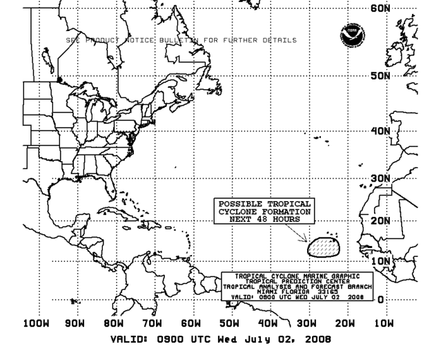
AREA FORECAST DISCUSSION
NATIONAL WEATHER SERVICE SAN JUAN PR
418 AM AST WED JUL 2 2008
.SYNOPSIS...
SATELLITE WIND ANALYSIS REVEALS LONG-LIVED SURFACE HIGH PRESSURE
SYSTEM ACROSS THE CENTRAL ATLANTIC NEAR 35N AND 58W MAINTAINING
EASTERLY WIND COMPONENTS ACROSS THE FORECAST AREA. MULTIPLE
TROPICAL WAVES CAN BE SEEN ALONG AND NEAR 10N THAT WILL CONTINUE
TO PUSH WESTWARD JUST SOUTH OF PUERTO RICO AND THE U.S.V.I.
MEANWHILE...A COLD FRONT OFF THE EAST COAST OF THE UNITED STATES
HAS SLOWED ITS EASTWARD PROPAGATION AS A RESULT OF THE ATLANTIC
HIGH. THIS FEATURE SHOULD NOT AFFECT THE ISLANDS.
&&
.DISCUSSION...
ATLANTIC ANTICYCLONE WILL BEGIN TO PROPAGATE AND REPOSITION
ITSELF SLOWLY EASTWARD OVER THE COURSE OF THE NEXT SEVERAL DAYS.
THIS WILL BE EVIDENT BY THE GRADUAL 700-850 MB WIND SHIFT FROM
EAST TO SOUTHEAST BY THIS AFTERNOON. WINDS OUT OF THIS DIRECTION
WILL SLIGHTLY INCREASE THE TEMPERATURE ALONG THE NORTHERN COAST OF
PUERTO RICO DUE TO A DOWNSLOPE EFFECT AS WELL AS SHIFT THE DIURNAL
PRECIPITATION BULLSEYE FROM THE WESTERN INTERIOR TO THE
NORTHWESTERN INTERIOR FOR WEDNESDAY.
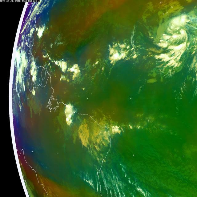
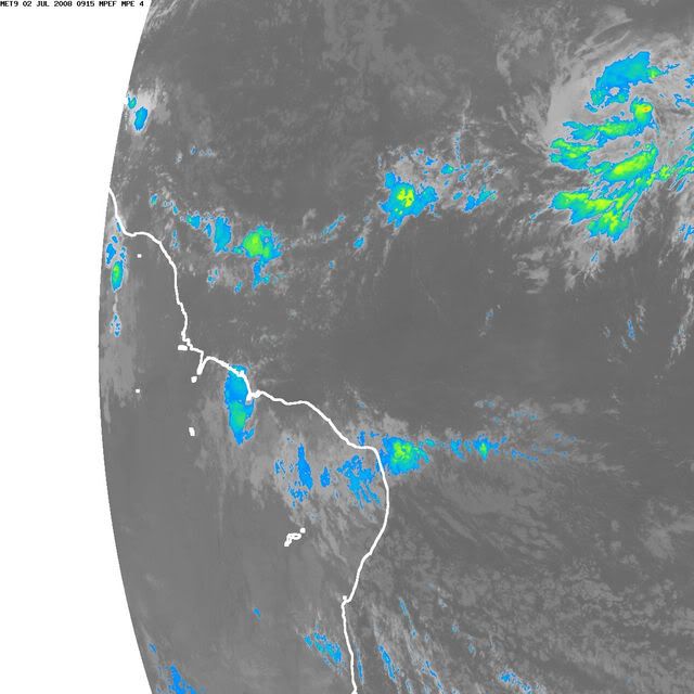
MULTIPLE WAVES ALONG THE ITCZ IN THE TROPICAL ATLANTIC CAN BE SEEN
VIA LATEST SATELLITE IMAGERY THIS MORNING. WHILE THE LARGEST AND
MOST IMPRESSIVE TROPICAL WAVE WITH TWO DISTINCT EASTERN AND
WESTERN VORT MAXES OFF THE COAST OF AFRICA HAS CAUGHT THE
ATTENTION OF MANY...IT REMAINS NEARLY A WEEK AWAY FROM THE LESSER
ANTILLES. OF MORE IMMEDIATE CONCERN WILL BE THE TROPICAL WAVE
LOCATED NEAR 10N AND 52W...WHICH IS EXPECTED TO PROPAGATE
WESTWARD JUST SOUTH OF PUERTO RICO AND THE U.S.V.I. THE PROXIMITY
OF THE WAVE TO THE LOCAL AREA WILL INCREASE THE POTENTIAL FOR
INCREASED SHOWER ACTIVITY THURSDAY THROUGH FRIDAY.
THE LATEST ENSEMBLE GUIDANCE FOR THE IMPRESSIVE TROPICAL WAVE THAT
EXITED THE AFRICAN COAST SUGGEST A MORE NORTHWEST TURN WITH TIME
AS THE SURFACE HIGH IN THE ATLANTIC SHIFTS EASTWARD. IF THIS IS
CONFIRMED...ANY POTENTIAL TROPICAL DEVELOPMENT FROM THIS WAVE MAY
BYPASS THE ISLANDS AND THE LOCAL FORECAST AREA...LEAVING THE
POTENTIAL ONLY FOR INCREASED SEAS. OF COURSE...DUE TO THE NATURE
OF THESE SYSTEMS COMBINED WITH NUMERICAL WEATHER PREDICTION FORECAST
TRACK ERROR THIS FAR INTO THE FUTURE...IT IS IMPERATIVE THAT
RESIDENTS...TOURISTS...AND MARINERS STAY TUNED TO FUTURE UPDATES
FROM THE NATIONAL WEATHER SERVICE.
NATIONAL WEATHER SERVICE SAN JUAN PR
418 AM AST WED JUL 2 2008
.SYNOPSIS...
SATELLITE WIND ANALYSIS REVEALS LONG-LIVED SURFACE HIGH PRESSURE
SYSTEM ACROSS THE CENTRAL ATLANTIC NEAR 35N AND 58W MAINTAINING
EASTERLY WIND COMPONENTS ACROSS THE FORECAST AREA. MULTIPLE
TROPICAL WAVES CAN BE SEEN ALONG AND NEAR 10N THAT WILL CONTINUE
TO PUSH WESTWARD JUST SOUTH OF PUERTO RICO AND THE U.S.V.I.
MEANWHILE...A COLD FRONT OFF THE EAST COAST OF THE UNITED STATES
HAS SLOWED ITS EASTWARD PROPAGATION AS A RESULT OF THE ATLANTIC
HIGH. THIS FEATURE SHOULD NOT AFFECT THE ISLANDS.
&&
.DISCUSSION...
ATLANTIC ANTICYCLONE WILL BEGIN TO PROPAGATE AND REPOSITION
ITSELF SLOWLY EASTWARD OVER THE COURSE OF THE NEXT SEVERAL DAYS.
THIS WILL BE EVIDENT BY THE GRADUAL 700-850 MB WIND SHIFT FROM
EAST TO SOUTHEAST BY THIS AFTERNOON. WINDS OUT OF THIS DIRECTION
WILL SLIGHTLY INCREASE THE TEMPERATURE ALONG THE NORTHERN COAST OF
PUERTO RICO DUE TO A DOWNSLOPE EFFECT AS WELL AS SHIFT THE DIURNAL
PRECIPITATION BULLSEYE FROM THE WESTERN INTERIOR TO THE
NORTHWESTERN INTERIOR FOR WEDNESDAY.
MULTIPLE WAVES ALONG THE ITCZ IN THE TROPICAL ATLANTIC CAN BE SEEN
VIA LATEST SATELLITE IMAGERY THIS MORNING. WHILE THE LARGEST AND
MOST IMPRESSIVE TROPICAL WAVE WITH TWO DISTINCT EASTERN AND
WESTERN VORT MAXES OFF THE COAST OF AFRICA HAS CAUGHT THE
ATTENTION OF MANY...IT REMAINS NEARLY A WEEK AWAY FROM THE LESSER
ANTILLES. OF MORE IMMEDIATE CONCERN WILL BE THE TROPICAL WAVE
LOCATED NEAR 10N AND 52W...WHICH IS EXPECTED TO PROPAGATE
WESTWARD JUST SOUTH OF PUERTO RICO AND THE U.S.V.I. THE PROXIMITY
OF THE WAVE TO THE LOCAL AREA WILL INCREASE THE POTENTIAL FOR
INCREASED SHOWER ACTIVITY THURSDAY THROUGH FRIDAY.
THE LATEST ENSEMBLE GUIDANCE FOR THE IMPRESSIVE TROPICAL WAVE THAT
EXITED THE AFRICAN COAST SUGGEST A MORE NORTHWEST TURN WITH TIME
AS THE SURFACE HIGH IN THE ATLANTIC SHIFTS EASTWARD. IF THIS IS
CONFIRMED...ANY POTENTIAL TROPICAL DEVELOPMENT FROM THIS WAVE MAY
BYPASS THE ISLANDS AND THE LOCAL FORECAST AREA...LEAVING THE
POTENTIAL ONLY FOR INCREASED SEAS. OF COURSE...DUE TO THE NATURE
OF THESE SYSTEMS COMBINED WITH NUMERICAL WEATHER PREDICTION FORECAST
TRACK ERROR THIS FAR INTO THE FUTURE...IT IS IMPERATIVE THAT
RESIDENTS...TOURISTS...AND MARINERS STAY TUNED TO FUTURE UPDATES
FROM THE NATIONAL WEATHER SERVICE.
0 likes

I don't think its a TD just yet but its still getting stronger and better organised.
I think here we are really seeing the benefit of the above normal temps in the east Atlantic and lower then normal shear. SAL is fairly low as the wave in front took a big hit for it and so therefore in theory there is no reason it should not form other then the time of year but in the end a tropical cyclone won't care about that if conditions are favorable it will form.
By far and away the best looking wave this season though even if nothing happens to it. Probably got another 48hrs before it reaches slightly cooler waters, then should remerge into the warmer waters between 120-144hrs.
0 likes
-
Matt-hurricanewatcher
Re:
KWT wrote:Convection isn't all that deep right now and the system doesn't look quite as good as it did last night but these systems do tend to wax and wane a little bit when they are developing so not going to read too much into it yet Matt, lets see what it looks like in another few hours time.
I agree with the wax and waning, but I believe it has about 24-30 hours to really get going before it hits the 35 west mark. Once past that then all bets are off.
0 likes


Who is online
Users browsing this forum: No registered users and 21 guests