

convection firing right over the apparent center...
Moderator: S2k Moderators


MiamiensisWx wrote:I have rescinded my previous decision and I will resume posting here. I still don't believe it will develop (per my latest analysis), but the challenges of forecasting are manifesting themselves in this situation.

MiamiensisWx wrote:In regards to the possible path, the strong subtropical ridging at 700-850 mb may result in a movement slightly further south than the majority of the model guidance. It is very early in the potential "life span" of this system, and it is difficult to place undue weight into the models until we have a defined low level circulation. Currently, there is an area of low pressure at the surface, and we undoubtedly have a weak surface low, but there is no evident LLC. Overall, it is objective to avoid placing trust into the intensities progged by the SHIP et al, as well as the model "clusters" in regards to the track. You simply cannot trust any prognostications. The one tidbit that I will denote is the possible slight bias toward a more rapid NW turn. If the system deepens more rapidly, it will likely be influenced by the upper low that is currently located well NE of the Leeward Islands. Therefore, in that case, the northward solution is more palpable and plausible. However, if intensification is slower (as I anticipate), a more westerly path of the surface low may easily occur in reality, since the low level steering would support that scenario.
http://cimss.ssec.wisc.edu/tropic/real-time/atlantic/winds/wg8dlm1.html
RL3AO wrote:Miami, where is this weakness that the models keep seeing, or is it turning north in the models because of the strengthening and getting affected by the ULL you mentioned?
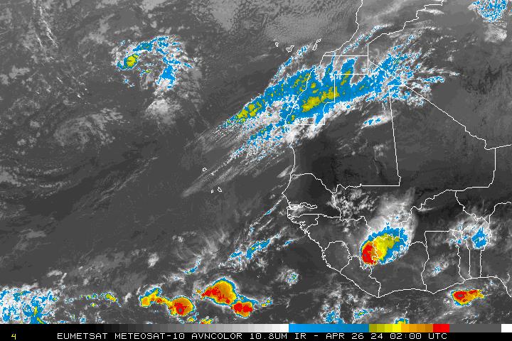
Jason_B wrote:Is that ball of convection over Africa associated with 92L or something else?


Jason_B wrote:Is that ball of convection over Africa associated with 92L or something else?


gatorcane wrote:I've been reading through the last several hours of post. I'm still going with my forecast from earlier today. I really don't see rapid intensification as shown by SHIPs. I expect possible slow development, if any, with a marked decrease in convection coverage as it heads west.
You really have to look at the SSTs ahead of the system. While they are high just off Africa, they do cool as you go west. Consequently I don't see this system rapidly intensifying. I don't see any NW turn at all. Just a west to west southwest course initially followed by a west to WNW course as the system remains at strong tropical wave with an attached low or a depression.
and SAL is another issue in this thing's path. It should help decrease the convection as well. If it goes poof by the time it hits those slightly lower SSTs it really would not surprise me although I am expecting at most a depression moving westbound for the next several days.
gatorcane wrote:The following post is NOT an official forecast and should not be used as such. It is just the opinion of the poster and may or may not be backed by sound meteorological data. It is NOT endorsed by any professional institution including storm2k.org For Official Information please refer to the NHC and NWS products.
I've been reading through the last several hours of post. I'm still going with my forecast from earlier today. I really don't see rapid intensification as shown by SHIPs. I expect possible slow development, if any, with a marked decrease in convection coverage as it heads west.
You really have to look at the SSTs ahead of the system. While they are high just off Africa, they do cool as you go west. Consequently I don't see this system rapidly intensifying. I don't see any NW turn at all. Just a west to west southwest course initially followed by a west to WNW course as the system remains at strong tropical wave with an attached low or a depression.
and SAL is another issue in this thing's path. It should help decrease the convection as well. If it goes poof by the time it hits those slightly lower SSTs it really would not surprise me although I am expecting at most a depression moving westbound for the next several days.

Users browsing this forum: No registered users and 57 guests


