TC Bertha

Moderator: S2k Moderators

Message
Author
User avatar
gatorcane
S2K Supporter
S2K Supporter
Posts: 23691
Age: 47
Joined: Sun Mar 13, 2005 3:54 pm
Location: Boca Raton, FL

Re:

#121 Postby gatorcane » Tue Jul 01, 2008 1:03 pm

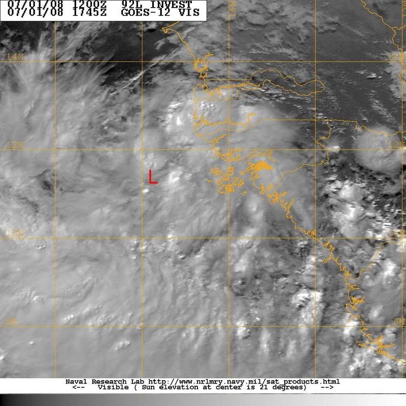
Frank2 wrote:Yes, but, the GFS does show a weaking of the western portion of the subtropical high over the next 5 days or so, so, that will be critical in where anything that might form does go...


Frank UKMET, Euro, and CMC do not see such a weakness. The models are not fully agreeing where this thing is headed unfortunately.
0 likes   

RL3AO
Moderator-Pro Met
Moderator-Pro Met
Posts: 16308
Joined: Thu Jun 14, 2007 10:03 pm
Location: NC

#122 Postby RL3AO » Tue Jul 01, 2008 1:06 pm

I think the models are strengthening it too much. If it does develop, I think it would peak at a 50kt storm tops. I don't see this huge dart to the north.


The posts in this forum are NOT official forecast and should not be used as such. They are just the opinion of the poster and may or may not be backed by sound meteorological data. They are NOT endorsed by any professional institution or storm2k.org. For official information, please refer to the NHC and NWS products.
0 likes   

User avatar
cycloneye
Admin
Admin
Posts: 145286
Age: 68
Joined: Thu Oct 10, 2002 10:54 am
Location: San Juan, Puerto Rico

Re: INVEST 92L in the Eastern Atlantic

#123 Postby cycloneye » Tue Jul 01, 2008 1:06 pm

Image

Image

Image

Convection has weakened some in the past 3 hours.
0 likes   

User avatar
NDG
S2K Supporter
S2K Supporter
Posts: 15446
Joined: Sun Jul 09, 2006 10:14 pm
Location: Orlando, FL

#124 Postby NDG » Tue Jul 01, 2008 1:07 pm

I am ignoring the GFS because it keeps 92L with the same strength over mid 70s SST west of CV islands, IMPOSSIBLE! Though a much northward track, if it gains any latitude after passing the CV islands to the south, it should weaken considerably and then go back to a westward track, very similar to the CMCs track
0 likes   

User avatar
deltadog03
Professional-Met
Professional-Met
Posts: 3580
Joined: Tue Jul 05, 2005 6:16 pm
Location: Macon, GA

#125 Postby deltadog03 » Tue Jul 01, 2008 1:09 pm

I know everyone is excited, but lets remember something here. Most models tend to over strengthen these systems too quickly. The usually are weaker longer and tend to follow the low level flow first. Second, GFS loves to underestimate the strength of the subtropical ridge. Now, what does this mean....don't know for sure yet. I would guess that this should move west to WNW for the next couple of days.
0 likes   

User avatar
gatorcane
S2K Supporter
S2K Supporter
Posts: 23691
Age: 47
Joined: Sun Mar 13, 2005 3:54 pm
Location: Boca Raton, FL

#126 Postby gatorcane » Tue Jul 01, 2008 1:09 pm

Note even NWS miami extended is not jumping on the GFS EC trough forecast yet:

FOR THE WEEKEND...THE LAST FEW RUNS OF THE GFS HAS TRENDED AWAY
FROM THE DEEP EASTERLY FLOW OF PREVIOUS DAYS AND INSTEAD
REDEVELOPS A TROUGH ACROSS THE MID-ATLANTIC REGION...OPENING UP A
WEAKNESS IN THE 500MB RIDGE AND ALLOWING MORE
SOUTHERLY/SOUTHEASTERLY LOW LEVEL FLOW ACROSS SOUTH FL. THIS COULD
LEAD TO AN INCREASE IN PWATS AND CONVECTIVE ACTIVITY ACROSS THE
REGION ONCE AGAIN...BUT WILL NOT MAKE MAJOR CHANGES AT THIS TIME
UNTIL THIS TREND IS SEEN IN MORE THAN 1 OR 2 MODEL RUNS.
0 likes   

User avatar
cycloneye
Admin
Admin
Posts: 145286
Age: 68
Joined: Thu Oct 10, 2002 10:54 am
Location: San Juan, Puerto Rico

Re: INVEST 92L in the Eastern Atlantic

#127 Postby cycloneye » Tue Jul 01, 2008 1:10 pm

AXNT20 KNHC 011806
TWDAT

TROPICAL WEATHER DISCUSSION
NWS TPC/NATIONAL HURRICANE CENTER MIAMI FL
205 PM EDT TUE JUL 01 2008

TROPICAL WEATHER DISCUSSION FOR NORTH AMERICA...CENTRAL
AMERICA...GULF OF MEXICO...CARIBBEAN SEA...NORTHERN SECTIONS OF
SOUTH AMERICA...AND ATLANTIC OCEAN TO THE AFRICAN COAST FROM THE
EQUATOR TO 32N. THE FOLLOWING INFORMATION IS BASED ON SATELLITE
IMAGERY...METEOROLOGICAL ANALYSIS...WEATHER OBSERVATIONS...AND
RADAR.

BASED ON 1200 UTC SURFACE ANALYSIS AND SATELLITE IMAGERY THROUGH
1715 UTC.

...TROPICAL WAVES...

STRONG TROPICAL WAVE IS OFF THE COAST OF W AFRICA ALONG 17W
S OF 19N ESTIMATED TO BE MOVING W 15 KT. A 1011 MB SFC LOW IS
SITUATED ALONG THE AXIS NEAR 11N...VERY NEAR A RECENT BURST OF
DEEP CONVECTION. THIS WAVE IS RATHER VIGOROUS EXHIBITING WELL
DEFINED CYCLONIC TURNING AND SCATTERED MODERATE CONVECTION
WITHIN 240 NM EITHER SIDE OF THE AXIS. THIS WAVE WILL BE CLOSELY
MONITORED FOR FURTHER DEVELOPMENT.
0 likes   

CrazyC83
Professional-Met
Professional-Met
Posts: 34002
Joined: Tue Mar 07, 2006 11:57 pm
Location: Deep South, for the first time!

#128 Postby CrazyC83 » Tue Jul 01, 2008 1:31 pm

Remember that climatology does not favor development in the deep tropics this early.
0 likes   

RL3AO
Moderator-Pro Met
Moderator-Pro Met
Posts: 16308
Joined: Thu Jun 14, 2007 10:03 pm
Location: NC

Re:

#129 Postby RL3AO » Tue Jul 01, 2008 1:33 pm

CrazyC83 wrote:Remember that climatology does not favor development in the deep tropics this early.


Yes. Normally there is high wind shear, cooler SSTs, and a lot of SAL. However, right now there is low wind shear, warm SSTs and little SAL. Yes climatology says storm should not develop out there in July. Reality tells us that storms can develop out there right now because conditions allow it.
0 likes   

User avatar
CourierPR
Category 5
Category 5
Posts: 1335
Age: 71
Joined: Tue Aug 31, 2004 7:53 pm
Location: Pompano Beach, Florida

Re:

#130 Postby CourierPR » Tue Jul 01, 2008 1:36 pm

CrazyC83 wrote:Remember that climatology does not favor development in the deep tropics this early.
Climatology serves as an historical guide, not as a rule book for every instance of possible development.
0 likes   

User avatar
PTrackerLA
Category 5
Category 5
Posts: 5277
Age: 41
Joined: Thu Oct 10, 2002 8:40 pm
Location: Lafayette, LA

Re: INVEST 92L in the Eastern Atlantic

#131 Postby PTrackerLA » Tue Jul 01, 2008 1:39 pm

After the 2005 season, especially July 2005, I learned never to discount something just based of climatology. It was literally thrown out the window that year.
0 likes   

User avatar
littlevince
S2K Supporter
S2K Supporter
Posts: 768
Joined: Fri Oct 21, 2005 10:45 am
Location: Portugal

Re: INVEST 92L in the Eastern Atlantic

#132 Postby littlevince » Tue Jul 01, 2008 1:40 pm

High resolution visible at 18:00 UTC:

Image
0 likes   

Aric Dunn
Category 5
Category 5
Posts: 21238
Age: 42
Joined: Sun Sep 19, 2004 9:58 pm
Location: Ready for the Chase.
Contact:

Re:

#133 Postby Aric Dunn » Tue Jul 01, 2008 1:42 pm

CrazyC83 wrote:Remember that climatology does not favor development in the deep tropics this early.

although i love climatology ! its helpful .. it does not however determine the present! just a reminder. it does not in anyway shape or form change the weather .. it is simply a history lesson.
:)


im excited i like when records are broken... i mean come on having Bertha (2008) BEATs bertha(1996) for the record for the farthest east formation in july .. i mean what are the odds ... all this assuming it get its act together fast enough ..
0 likes   

Ed Mahmoud

Re: INVEST 92L in the Eastern Atlantic

#134 Postby Ed Mahmoud » Tue Jul 01, 2008 1:44 pm

littlevince wrote:High resolution visible at 18:00 UTC:

Image


Low clouds to the South of that suggest there isn't much of a low level center yet. Of course, hard to be certain with a still image.
0 likes   

User avatar
gatorcane
S2K Supporter
S2K Supporter
Posts: 23691
Age: 47
Joined: Sun Mar 13, 2005 3:54 pm
Location: Boca Raton, FL

#135 Postby gatorcane » Tue Jul 01, 2008 1:53 pm

Accuweather satellite of Atlantic Basin showing 92L

Image
0 likes   

User avatar
cycloneye
Admin
Admin
Posts: 145286
Age: 68
Joined: Thu Oct 10, 2002 10:54 am
Location: San Juan, Puerto Rico

Re: INVEST 92L in the Eastern Atlantic

#136 Postby cycloneye » Tue Jul 01, 2008 1:53 pm

TD still far away.

01/1800 UTC 11.7N 17.2W TOO WEAK 92L -- Atlantic Ocean
0 likes   

User avatar
wxman57
Moderator-Pro Met
Moderator-Pro Met
Posts: 22978
Age: 67
Joined: Sat Jun 21, 2003 8:06 pm
Location: Houston, TX (southwest)

Re: INVEST 92L in the Eastern Atlantic

#137 Postby wxman57 » Tue Jul 01, 2008 1:54 pm

A little data here. I estimate the 1815Z position at 11.9N/17.8W. This position is about 280nm west of where it was at 1815Z yesterday. Actually, I measure a heading of 280.9 degrees for the past 24 hours. That's a forward speed of 11.7 kts. Pretty far to the north already. There's still an upper-level trof between 30-40W, a significant weakness in the ridge. If it develops in the next 2-3 days then it's highly unlikely it'll impact any land areas. I still think there's a better-than-not chance it won't develop and that convection will be decreasing tomorrow.

Image
0 likes   

User avatar
NDG
S2K Supporter
S2K Supporter
Posts: 15446
Joined: Sun Jul 09, 2006 10:14 pm
Location: Orlando, FL

#138 Postby NDG » Tue Jul 01, 2008 2:06 pm

After looking at the NRL site's loop of 92L I estimate the center of the broad low pressure to be near 11.3 N & 18W, nice convection firing up again to the east and NE of the center.
Image
0 likes   

User avatar
HURAKAN
Professional-Met
Professional-Met
Posts: 46086
Age: 38
Joined: Thu May 20, 2004 4:34 pm
Location: Key West, FL
Contact:

#139 Postby HURAKAN » Tue Jul 01, 2008 2:11 pm

Image
0 likes   

OuterBanker
S2K Supporter
S2K Supporter
Posts: 1731
Joined: Wed Feb 26, 2003 10:53 am
Location: Nags Head, NC
Contact:

Re: INVEST 92L in the Eastern Atlantic

#140 Postby OuterBanker » Tue Jul 01, 2008 2:17 pm

A little deja vu from TPC:

"Bertha originated from a tropical wave which moved from Africa to the Atlantic on 1 July. A weak circulation was first detected on satellite imagery on 3 July, centered about 500 n mi south of the Cape Verde Islands in the far eastern Atlantic Ocean. The track of the circulation center begins on 5 July, when the circulation is believed to have reached the surface and become a tropical depression, in the central tropical Atlantic"

Two questions for Mets: I assume we won't have any floaters until GOES picks it up (if it survives). Will TPC start tracking if they determine a center form METEOSAT or will they wait until GOES sees it?
0 likes   


Return to “2008”

Who is online

Users browsing this forum: No registered users and 3 guests