
WPAC: Ex-TY Fengshen 0806 (07W) 1,300 dead
Moderator: S2k Moderators


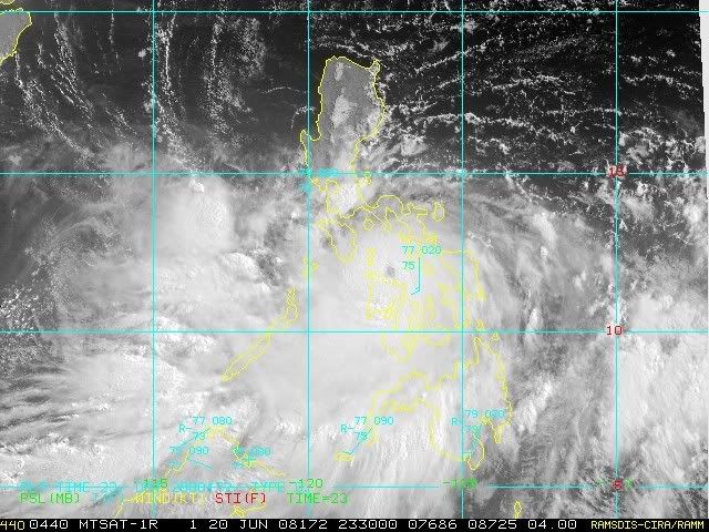
Wow this system is really holding well given just how much land is around it, I'd guess its probably closer to 95kts but thats just IMO. Still a very healthy looking system right now with some deep convection present, esp on the SW side. I think a track closer to the JTWC is looking more probable given its westward march compared to what was forecasted.
0 likes

-
Matt-hurricanewatcher
Re: WPAC: TY Fengshen 0806 (07W, PAGASA-Frank) Visaya Islands
This thing is exploding, while it is 30 percent over land. Amazing. IMO, it has 360 degree "yellow" IR ring in that is like Red on the other IR images. So I would say it's very likely around 120-125 knots and around 920 millibars. I feel sorry for anyone on those islands right now; because if the core stays off over the water this could become a "cat5" like storm, as it moves into the south China sea.
0 likes


Re: WPAC: TY Fengshen 0806 (07W, PAGASA-Frank) Visaya Islands
Has anyone had info from the Philippines yet?
My husbands friend has family there.
Dang but that really looks like a bad one!
My husbands friend has family there.
Dang but that really looks like a bad one!
0 likes


-
senorpepr

- Military Met/Moderator

- Posts: 12542
- Age: 43
- Joined: Fri Aug 22, 2003 9:22 pm
- Location: Mackenbach, Germany
- Contact:
Re: WPAC: TY Fengshen 0806 (07W, PAGASA-Frank) Visaya Islands
Typhoon 'Frank' lashes EVisayas, may hit [Metro Manila] Saturday night
Typhoon "Frank" (international codename Fengshen) smashed into the country’s third largest island Friday packing winds of 140 kilometers (87 miles) an hour as residents braced for flooding, landslides and big waves.
There were no immediate reports of casualties or damage as the storm scythed northwest across Samar, an impoverished island of 1.5 million people.
The country’s weather bureau, Philippine Atmospheric, Geophysical and Astronomical Services (PAGASA) said in its 11 p.m. bulletin the typhoon’s eye was located 50 kilometers southeast of Masbate island.
PAGASA said typhoon "Frank" has maximum sustained winds of 140 kilometers per hour near the center and gustiness of up to 170 kph.
The typhoon was expected to hit the Bicol peninsula on Luzon's southeastern tip on Saturday, and could then hit the Luzon heartland on Sunday.
PAGASA said the typhoon was moving west northwest at 19 kph. It expects the typhoon to cross Masbate then traverse the inland waters of Southern Luzon Friday night.
It forecast the storm to be 60 kilometers northeast of Metro Manila by Saturday evening.
By Sunday evening the typhoon is expected to be 30 kilometers south of Laoag City. The weather bureau expects the storm on Monday evening to be 110 kilometers northwest of Basco, Batanes.
Storm Signals
Public Storm Signal No. 3 is hoisted over Masbate, Sorsogon, Albay, Burias Island, Catanduanes, Camarines Provinces, Southern Quezon, Marinduque, Romblon, Oriental Mindoro, Samar Provinces, Leyte, Biliran Island, Capiz, Aklan and Northern Antique.
Public Storm Signal No. 2 is hoisted over Cuyo Island, Calamian Group, Occidental Mindoro, Batangas, Cavite, Laguna, Bulacan, Rest of Quezon, Rizal, Metro Manila, Southern Leyte, Northern Cebu, Northern Negros Occidental, Iloilo and the rest of Antique.
PAGASA also said that Public Storm Signal No. 1 is hoisted over Nueva Viscaya, Quirino, Aurora, Nueva Ecija, Pangasinan, Tarlac, Pampanga, Zambales, Northern Palawan, Lubang Island, rest of Negros Occidental, Negros Oriental, Siquijor Island, rest of Cebu, Bohol and Dinagat island.
The weather bureau, which upgraded "Frank" from a tropical storm on Friday, advised residents in low-lying areas and near mountain slopes to take all the necessary precautions against possible flashfloods and landslides. Likewise, those living in coastal areas under signal 2 and 3 are alerted against big waves or storm surges generated by this typhoon.
Stranded in ports
The National Disaster Coordinating Council (NDCC) in its 6 p.m. report Friday on the effects of the typhoon said that a total of 617 persons were stranded in various ports of the Bicol region as the Philippine Coast Guard suspended ferry services due to inclement weather.
In Central Visayas, four persons who went fishing were reported missing in Getate town in Bohol. A minor landslide was also reported by the NDCC to have occurred in Talisay City affecting the riprap of Manipis Elementary School.
Power failure was reported in the following provinces - Northern Samar - 3 p.m.; Eastern Samar - 8 a.m. and Samar - 4:30 p.m, reported NDCC.
Disaster preparations
Albay provincial officials on Friday called on residents living near Mayon Volcano or in mountain slopes as well as in coastal areas to evacuate due to the typhoon.
The province has already been placed under Storm Signal Number 3 by PAGASA. The powerful typhoon is expected to hit the province early Saturday morning.
The pre-emptive evacuation, ordered by Albay Gov. Joey Salceda, have already resulted in 23,086 families or 117,963 persons going to evacuation centers across the province.
"We are doing pre-emptive evacuation of 176,802 persons due to risk of lahar, landslide and floods" earlier said Albay Gov. Joey Salceda.
President Arroyo, who has been visiting the south, called off a visit to Panay island and had her plane diverted back to Davao City, presidential spokesman Secretary Jesus Dureza told reporters.
She urged local governments to prepare for the storm that could trigger flooding and landslides.
Arroyo has ordered that warnings be issued to all provinces along the typhoon's expected path, and for local governments to prepare for contingencies, senior aide Dr. Anthony Golez said in a statement.
The Armed Forces were also on "alert in order to support evacuation activities of local government units if needed," Golez said, while the social welfare department was beefing up its relief stockpiles.
Hundreds of people die in the Philippines every year due to floods and landslides caused by tropical storms or typhoons that sweep in mainly from the Pacific.
0 likes


As we've seen in recent years, typhoons that hit the Philippines around its southern islands tend not to lose a lot of strength thanks to the multiple eddies of very warm water between the islands.
JMA has it up to 90 kts.
826
WTPQ20 RJTD 210000
RSMC TROPICAL CYCLONE ADVISORY
NAME TY 0806 FENGSHEN (0806)
ANALYSIS
PSTN 210000UTC 11.9N 122.7E GOOD
MOVE W 07KT
PRES 945HPA
MXWD 090KT
GUST 130KT
50KT 55NM
30KT 160NM WEST 140NM EAST
FORECAST
24HF 220000UTC 14.5N 120.3E 70NM 70%
MOVE NW 09KT
PRES 960HPA
MXWD 080KT
GUST 115KT
48HF 230000UTC 17.6N 118.5E 110NM 70%
MOVE NNW 09KT
PRES 950HPA
MXWD 085KT
GUST 120KT
72HF 240000UTC 20.4N 117.2E 160NM 70%
MOVE NNW 08KT
PRES 945HPA
MXWD 090KT
GUST 130KT =
0 likes
-
HurricaneRobert
- Category 3

- Posts: 812
- Joined: Fri May 18, 2007 9:31 pm
Re: WPAC: TY Fengshen 0806 (07W, PAGASA-Frank) Visaya Islands
Its wobbled more to the west. I bet the next track will bring it near Hong Kong eventually.
0 likes


-
HURAKAN

- Professional-Met

- Posts: 46084
- Age: 39
- Joined: Thu May 20, 2004 4:34 pm
- Location: Key West, FL
- Contact:
Re: WPAC: TY Fengshen 0806 (07W, PAGASA-Frank) Visaya Islands
June 19 0000Z:

June 20 1800Z:

Yesterday the westernmost boundary of the area of possibilities brushed 125E. Today it reaches past 110E. WOW!
June 20 1800Z:
Yesterday the westernmost boundary of the area of possibilities brushed 125E. Today it reaches past 110E. WOW!
0 likes


-
cycloneye

- Admin

- Posts: 149829
- Age: 69
- Joined: Thu Oct 10, 2002 10:54 am
- Location: San Juan, Puerto Rico
Re: WPAC: TY Fengshen 0806 (07W, PAGASA-Frank) Visaya Islands
What happened with the pattern that changed bigtime the forecast track?
0 likes

Who is online
Users browsing this forum: No registered users and 23 guests