SEVERE WEATHER STATEMENT
NATIONAL WEATHER SERVICE NORTHERN INDIANA
850 PM EDT FRI JUN 6 2008
OHC003-137-161-070115-
/O.CON.KIWX.SV.W.0039.000000T0000Z-080607T0115Z/
PUTNAM OH-VAN WERT OH-ALLEN OH-
850 PM EDT FRI JUN 6 2008
...A SEVERE THUNDERSTORM WARNING REMAINS IN EFFECT UNTIL 915 PM EDT
FOR ALLEN...SOUTHEASTERN VAN WERT AND SOUTHERN PUTNAM COUNTIES IN
WEST CENTRAL OHIO...
AT 845 PM EDT...NATIONAL WEATHER SERVICE DOPPLER RADAR CONTINUED TO
INDICATE A LINE OF SEVERE THUNDERSTORMS CAPABLE OF PRODUCING
DESTRUCTIVE WINDS IN EXCESS OF 80 MPH. THESE SEVERE STORMS WERE
LOCATED ALONG A LINE EXTENDING FROM 9 MILES NORTHEAST OF
DELPHOS TO 7 MILES NORTHEAST OF ST. MARYS...AND MOVING EAST AT 70
MPH.
LOCATIONS IN THE PATH OF SEVERE THUNDERSTORMS INCLUDE...
LIMA AND FORT SHAWNEE...
BLUFFTON...
YODER...SLABTOWN AND ROUSCULP...
WESTMINSTER AND LAFAYETTE...
HARROD...
THIS IS A DANGEROUS LINE OF SEVERE THUNDERSTORMS. IF YOU ARE IN THE
PATH...PREPARE IMMEDIATELY FOR DESTRUCTIVE WINDS IN EXCESS OF 70
MPH...ALONG WITH DEADLY CLOUD TO GROUND LIGHTNING. PEOPLE OUTSIDE
SHOULD MOVE TO A SHELTER...PREFERABLY INSIDE A STRONG BUILDING BUT
AWAY FROM WINDOWS.
THIS LINE OF SEVERE THUNDERSTORMS HAS A HISTORY OF PRODUCING
WIDESPREAD WIND DAMAGE ACROSS. THIS IS AN EXTREMELY DANGEROUS
SITUATION. GO TO A BASEMENT OR SMALL INTERIOR ROOM. EVACUATE MOBILE
HOMES...AND SEEK SHELTER INSIDE A STURDY STRUCTURE.
IF YOU HAVE SEVERE WEATHER TO REPORT...YOU CAN CALL YOUR LOCAL LAW
ENFORCEMENT AGENCY FOR RELAY TO THE NATIONAL WEATHER SERVICE.
A TORNADO WATCH REMAINS IN EFFECT UNTIL 1000 PM EDT FRIDAY EVENING
FOR NORTHERN INDIANA AND SOUTHERN MICHIGAN AND NORTHWEST OHIO. A
TORNADO WATCH ALSO REMAINS IN EFFECT UNTIL MIDNIGHT EDT SATURDAY
MORNING FOR NORTHEASTERN INDIANA.
LAT...LON 4065 8421 4068 8422 4068 8444 4072 8445
4072 8459 4085 8460 4096 8387 4064 8388
TIME...MOT...LOC 0050Z 254DEG 64KT 4093 8407 4066 8421
$$
JC
June 4-7: Severe wx (Omaha tornado update)
Moderator: S2k Moderators
Forum rules

The posts in this forum are NOT official forecast and should not be used as such. They are just the opinion of the poster and may or may not be backed by sound meteorological data. They are NOT endorsed by any professional institution or STORM2K.

CNN
EMMAVILLE, Minnesota (AP) -- Strong storms smashed houses, deluged neighborhoods, toppled trees and left thousands without power across the Midwest on Friday in the latest round of fierce weather. No injuries were reported.
A tornado downed trees and overturned a trailer home near Pickerel Lake in Minnesota on Friday.
A tornado raked a half-mile-wide path of destruction in northwestern Minnesota, where a house overlooking Pickerel Lake near Emmaville was destroyed, it's contents spilling down the hill. Wooden chairs and tables were floating below. Nearby was a concrete slab the size of a two-car garage, but whatever structure once sat on it was blown away.
Flooding forced the evacuation of about a dozen homes in the central Iowa town of Cambridge, but areas to the southwest saw some of their roads and buildings re-emerge from subsiding waters in a much-needed respite from severe weather.
Heavy rains that began Thursday night seeped into most basements and at least one foundation collapsed, said Lori Morrissey, Story County's emergency management coordinator.
"The ground is just fully saturated," Morrissey said. "The runoff from the community just all comes to that part of town. This is probably the worst it's ever been."
In Illinois, the Chicago Department of Aviation said high winds and storms were causing delays and cancellations at the city's airports.
Delays at O'Hare International Airport were averaging 90 minutes late Friday afternoon, and dozens of flights were canceled. At Midway International Airport, some flights were delayed up to an hour.
Don't Miss
High winds blew the roof off an eastern Illinois lumber yard, sending debris through a nearby auto dealership. Also, 60-mph winds blew trucks off highways near Effingham and Champaign, but authorities said there were no immediate reports of injuries.
In Missouri, the Washington County Sheriff's Department said there were reports of a tornado touching down near Richwoods, about 65 miles southwest of St. Louis. No damage was immediately reported.
Flash flooding forced highways closed in Missouri and Minnesota, where a storm caused widespread damage in Park Rapids and an unincorporated town north of it called Emmaville.
No serious injuries were reported.
"Right now, I can tell you we've been fortunate," Sheriff Gary Mills said.
Susan Vessey said she's lived on the shore of the lake for 40 years and has never seen a storm like Friday's. "It was too fast to be scared," she said. Trees fell on her deck and roof, but there wasn't any damage to the inside of her house.
In Indiana, Gov. Mitch Daniels declared 41 counties disaster areas -- the first step to gain federal aid -- after severe storms and tornadoes. One person was killed and at least 10 injured in the round of storms this week.
advertisement
Daniels wore a hard hat as he toured a tornado-ravaged apartment complex in Indianapolis on Friday.
"No matter how many times I see it, I'm constantly amazed and awed by the human sprit and the spirit of compassion that characterizes our state," Daniels said.
0 likes
-
Siberian Express
- S2K Supporter

- Posts: 99
- Joined: Tue Sep 27, 2005 9:13 pm
- Location: Minnesota, USA
Re:
[quote="KWT"]Still got tornado warnings coming out, not sure why its so queit in here lol!
It gets pretty old just seeing a bunch of 'cut & paste' Meso discussions, watches and warnings, and having to scroll and scoll through all that junk.
Most of us here are well aware of what's going on, i.e. watches, warnings, meso discussions, etc.
Hopefully, people and lurkers are not relying on the cut and paste info most post here from the NWS for their "real time" info.....get a weather radio!
0 likes

Re: June 4-7: Severe weather outbreak
Minor tornado or microburst damage is being reported in Albion, MI, about 45 minutes south of Lansing.
http://www.battlecreekenquirer.com/apps ... 60031/1002
My in-laws live in the area, and they said it sounded like people always say tornadoes sound right before they hit. They had a part of a large cherry tree come down and hit the side of their house, but seem to have otherwise escaped damage.
http://www.battlecreekenquirer.com/apps ... 60031/1002
My in-laws live in the area, and they said it sounded like people always say tornadoes sound right before they hit. They had a part of a large cherry tree come down and hit the side of their house, but seem to have otherwise escaped damage.
0 likes
-
Stephanie

- S2K Supporter
- Posts: 23843
- Age: 63
- Joined: Thu Feb 06, 2003 9:53 am
- Location: Glassboro, NJ
Re: June 4-7: Severe weather outbreak
Merged Bunkertor's "To be Deleted" thread with this one.
0 likes
-
PurdueWx80
- Professional-Met

- Posts: 2720
- Joined: Fri Aug 13, 2004 8:33 pm
- Location: Madison, WI
- Contact:
Re: June 4-7: Severe weather outbreak
today looks as or more active than yesterday, but a bit further west, across the corn belt. deep tropical moisture is returning north rapidly, with dewpoints soaring into the low and mid-70s across most of the midwest. with at least partial sunshine, it will become very unstable by mid-day. shear is still quite good across the area, and yesterday's cap is more or less gone.
the quality of low-level moisture underneath good directional and speed shear suggest numerous supercells will form today, and many of them will be capable of tornadoes from eastern NE to WI. wet microbursts seem look a pretty good possibility too.
of perhaps equal concern will be flooding through the weekend as storms train over the same area. the last few high-res runs of the WRF are putting out widespread 3-5" rainfall totals over parts of iowa and wisconsin, with localized 7-10" amounts, as well. this, on top of the recent heavy rain, will probably create major flooding across the region.
the speed shear isn't as impressive sunday, but i still think there will be quite a few tornadoes over roughly the same area, as there will be numerous outflow boundaries around to enhance low-level shear.
the hyperactive severe wx pattern should continue much of next week across the plains, midwest and ohio valley.
0 likes
-
6SpeedTA95
- Category 5

- Posts: 1206
- Joined: Wed Oct 19, 2005 3:25 pm
- Location: Oklahoma
- Contact:
-
6SpeedTA95
- Category 5
- Posts: 1206
- Joined: Wed Oct 19, 2005 3:25 pm
- Location: Oklahoma
- Contact:
SEVERE WEATHER STATEMENT
NATIONAL WEATHER SERVICE LA CROSSE WI
1243 PM CDT SAT JUN 7 2008
WIC057-081-123-071815-
/O.CON.KARX.TO.W.0009.000000T0000Z-080607T1815Z/
JUNEAU WI-MONROE WI-VERNON WI-
1243 PM CDT SAT JUN 7 2008
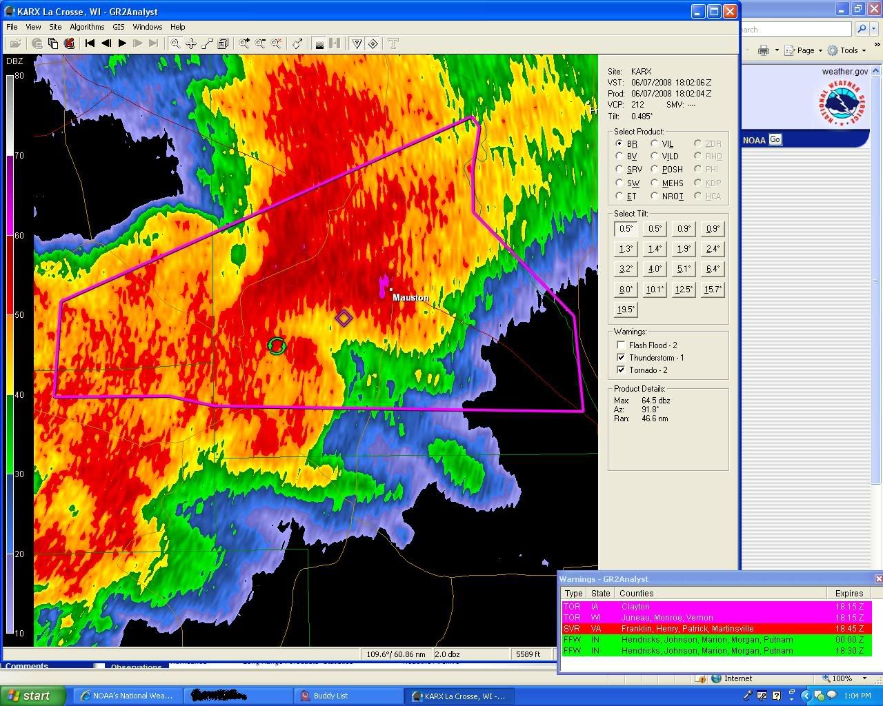
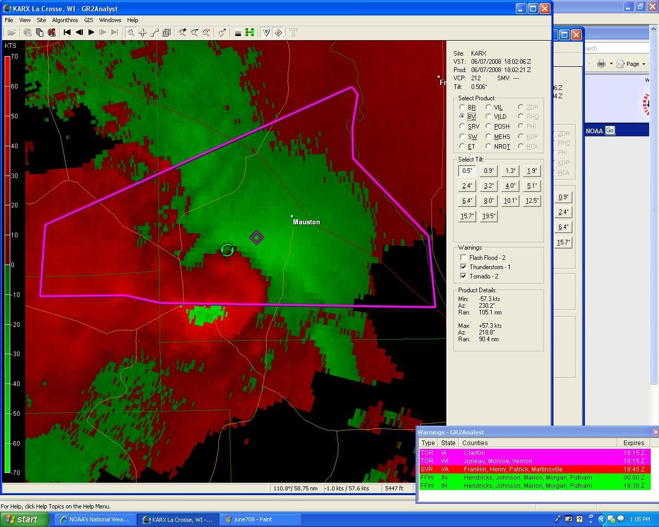
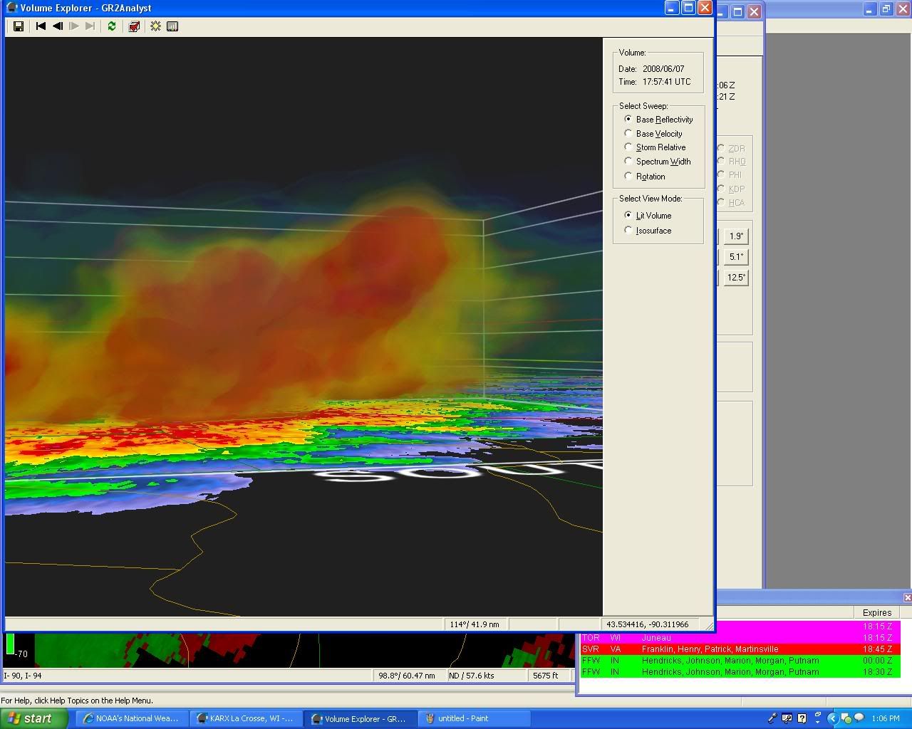
...A TORNADO WARNING REMAINS IN EFFECT UNTIL 115 PM CDT FOR
NORTHEASTERN VERNON...SOUTHEASTERN MONROE AND SOUTHERN JUNEAU
COUNTIES...
AT 1243 PM CDT...WEATHER SERVICE DOPPLER RADAR CONTINUED TO INDICATE
A SEVERE THUNDERSTORM WITH STRONG ROTATION. THIS TORNADO WAS LOCATED
NEAR HOFFMAN CORNERS...OR ABOUT 18 MILES SOUTH OF TOMAH...MOVING EAST
AT 35 MPH.
* THE TORNADO WILL BE NEAR...
GLENDALE AND KENDALL AROUND 1250 PM...
ELROY AROUND 100 PM...
MULLIN RIDGE AND PLEASANT RIDGE AROUND 105 PM...
NEW LISBON AND LINDINA AROUND 110 PM...
MAUSTON AND I 90 94 EXIT 69 AROUND 115 PM...
CARS AND MOBILE HOMES SHOULD BE ABANDONED FOR A STURDY BUILDING. AS A
LAST RESORT...LAY FLAT IN A DITCH AND COVER YOUR HEAD.
NATIONAL WEATHER SERVICE LA CROSSE WI
1243 PM CDT SAT JUN 7 2008
WIC057-081-123-071815-
/O.CON.KARX.TO.W.0009.000000T0000Z-080607T1815Z/
JUNEAU WI-MONROE WI-VERNON WI-
1243 PM CDT SAT JUN 7 2008
...A TORNADO WARNING REMAINS IN EFFECT UNTIL 115 PM CDT FOR
NORTHEASTERN VERNON...SOUTHEASTERN MONROE AND SOUTHERN JUNEAU
COUNTIES...
AT 1243 PM CDT...WEATHER SERVICE DOPPLER RADAR CONTINUED TO INDICATE
A SEVERE THUNDERSTORM WITH STRONG ROTATION. THIS TORNADO WAS LOCATED
NEAR HOFFMAN CORNERS...OR ABOUT 18 MILES SOUTH OF TOMAH...MOVING EAST
AT 35 MPH.
* THE TORNADO WILL BE NEAR...
GLENDALE AND KENDALL AROUND 1250 PM...
ELROY AROUND 100 PM...
MULLIN RIDGE AND PLEASANT RIDGE AROUND 105 PM...
NEW LISBON AND LINDINA AROUND 110 PM...
MAUSTON AND I 90 94 EXIT 69 AROUND 115 PM...
CARS AND MOBILE HOMES SHOULD BE ABANDONED FOR A STURDY BUILDING. AS A
LAST RESORT...LAY FLAT IN A DITCH AND COVER YOUR HEAD.
0 likes
-
6SpeedTA95
- Category 5
- Posts: 1206
- Joined: Wed Oct 19, 2005 3:25 pm
- Location: Oklahoma
- Contact:


Well, things are starting to get interesting around here. There are a lot of warnings popping up, mostly north of Madison, right now.
It is very hot here, and the humidity is oppressive. The sun's out, too, so I'm thinking things are going to be popping up quite a bit over the next couple of hours.
It is very hot here, and the humidity is oppressive. The sun's out, too, so I'm thinking things are going to be popping up quite a bit over the next couple of hours.
0 likes
-
PurdueWx80
- Professional-Met
- Posts: 2720
- Joined: Fri Aug 13, 2004 8:33 pm
- Location: Madison, WI
- Contact:
Re: June 4-7: Severe weather outbreak
i live on the north shore of lake monona, and the winds have really picked up in the last half hour - out of the south-southeast. the storms to our north seem to be forming some sort of meso-low, which is causing winds to back a bit. basically, that's just gonna enhance the low-level helicity and contribute to the development of tornadoes along this line. we're really gonna have to watch the storm over southwest wisconsin, as it will come very close to madison near or a bit after 3.
its pretty rare for us to see such high humidity this early in the year. normally, it happens in july and august when the corn crop is big and healthy. and i agree, it's oppressive!
its pretty rare for us to see such high humidity this early in the year. normally, it happens in july and august when the corn crop is big and healthy. and i agree, it's oppressive!
0 likes


PurdueWx80 wrote:i live on the north shore of lake monona, and the winds have really picked up in the last half hour - out of the south-southeast. the storms to our north seem to be forming some sort of meso-low, which is causing winds to back a bit. basically, that's just gonna enhance the low-level helicity and contribute to the development of tornadoes along this line. we're really gonna have to watch the storm over southwest wisconsin, as it will come very close to madison near or a bit after 3.
its pretty rare for us to see such high humidity this early in the year. normally, it happens in july and august when the corn crop is big and healthy. and i agree, it's oppressive!
I somehow feel better with someone else from Madison on the board today!
My parents went down into Rock county to work outside at my sister's. This was against my advice. Heck, I am supposed to be going somewhere around 3:00 but I'm deciding to stay home until things calm.
0 likes
Eep. I'm starting to get nervous.
SEVERE WEATHER STATEMENT
NATIONAL WEATHER SERVICE LA CROSSE WI
209 PM CDT SAT JUN 7 2008
WIC043-071930-
/O.CON.KARX.TO.W.0013.000000T0000Z-080607T1930Z/
GRANT WI-
209 PM CDT SAT JUN 7 2008
...A TORNADO WARNING REMAINS IN EFFECT UNTIL 230 PM CDT FOR NORTHERN
GRANT COUNTY...
AT 208 PM CDT...LOCAL LAW ENFORCEMENT REPORTED A TORNADO ON THE
GROUND NEAR WOODMAN. THIS TORNADO WAS LOCATED NEAR WOODMAN...OR
ABOUT 18 MILES NORTH OF LANCASTER...MOVING EAST AT 26 MPH. TAKE
COVER NOW IN NORTHERN GRANT COUNTY!
* THE TORNADO WILL BE NEAR...
HICKORY GROVE AROUND 225 PM...
MUSCODA AND BLUE RIVER AROUND 230 PM...
PLEASE REPORT ANY SEVERE WEATHER TO YOUR LOCAL LAW ENFORCEMENT OFFICE
AND TELL THEM TO RELAY YOUR REPORT TO THE NATIONAL WEATHER SERVICE.
LAT...LON 4306 9095 4310 9079 4318 9067 4319 9060
4321 9055 4320 9050 4320 9043 4319 9042
4305 9042 4303 9093
TIME...MOT...LOC 1909Z 256DEG 23KT 4310 9074
$$
BINAU
0 likes
-
PurdueWx80
- Professional-Met
- Posts: 2720
- Joined: Fri Aug 13, 2004 8:33 pm
- Location: Madison, WI
- Contact:
winds are always a little stronger right on the lake. gusting close to 50 now. some small limbs are falling (and laying next to the ones that fell yesterday).
that storm is now bowing out to our north - it's going to produce a swath of major damage perhaps even into the eastern half of dane county and probably into much of SE WI.
i'm also really worried about flooding that could near what we saw last august. what a crazy year for weather.
that storm is now bowing out to our north - it's going to produce a swath of major damage perhaps even into the eastern half of dane county and probably into much of SE WI.
i'm also really worried about flooding that could near what we saw last august. what a crazy year for weather.
0 likes
-
6SpeedTA95
- Category 5
- Posts: 1206
- Joined: Wed Oct 19, 2005 3:25 pm
- Location: Oklahoma
- Contact:
Re:
tidesong wrote:Winds are picking up here. I just put my car in the garage. I'm getting a bit more nervous.
Where are you located?
0 likes
-
6SpeedTA95
- Category 5
- Posts: 1206
- Joined: Wed Oct 19, 2005 3:25 pm
- Location: Oklahoma
- Contact:
Re: Re:
tidesong wrote:6SpeedTA95 wrote:Where are you located?
East side of Madison, WI. Stuff right now looks to be passing to the north of here by a county.
Yeah it is, you could be under the gun later though.
0 likes
Return to “USA & Caribbean Weather”
Who is online
Users browsing this forum: No registered users and 126 guests