Memorial Day Weekend Outbreak 2008
Moderator: S2k Moderators
Forum rules

The posts in this forum are NOT official forecast and should not be used as such. They are just the opinion of the poster and may or may not be backed by sound meteorological data. They are NOT endorsed by any professional institution or STORM2K.
-
6SpeedTA95
- Category 5

- Posts: 1206
- Joined: Wed Oct 19, 2005 3:25 pm
- Location: Oklahoma
- Contact:
Re: Re:
CrazyC83 wrote:RL3AO wrote:The squall line has caught up to the Kiowa cell.
The squall line is breaking down though - discrete supercells starting to form on it.
I was noticing that too
0 likes

-
HarlequinBoy

- Category 5
- Posts: 1400
- Age: 35
- Joined: Wed Nov 29, 2006 1:57 am
- Location: Memphis
-
6SpeedTA95
- Category 5
- Posts: 1206
- Joined: Wed Oct 19, 2005 3:25 pm
- Location: Oklahoma
- Contact:
-
CrazyC83
- Professional-Met

- Posts: 34315
- Joined: Tue Mar 07, 2006 11:57 pm
- Location: Deep South, for the first time!
Re:
6SpeedTA95 wrote:Man, great call by NWS going with a PDS on this watch, this is ridiculous.
I agree the PDS was well warranted. A high risk might have been warranted as well, although there were still a few question marks at 2000Z (it is virtually unheard-of these days to upgrade at 0100Z).
0 likes
-
6SpeedTA95
- Category 5
- Posts: 1206
- Joined: Wed Oct 19, 2005 3:25 pm
- Location: Oklahoma
- Contact:
Re: Re:
CrazyC83 wrote:6SpeedTA95 wrote:Man, great call by NWS going with a PDS on this watch, this is ridiculous.
I agree the PDS was well warranted. A high risk might have been warranted as well, although there were still a few question marks at 2000Z (it is virtually unheard-of these days to upgrade at 0100Z).
Yeah I agree.
0 likes
-
HarlequinBoy
- Category 5
- Posts: 1400
- Age: 35
- Joined: Wed Nov 29, 2006 1:57 am
- Location: Memphis
-
CrazyC83
- Professional-Met
- Posts: 34315
- Joined: Tue Mar 07, 2006 11:57 pm
- Location: Deep South, for the first time!
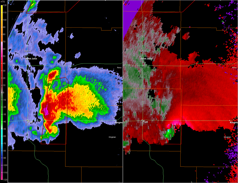
Re: Tornado outbreak again today?
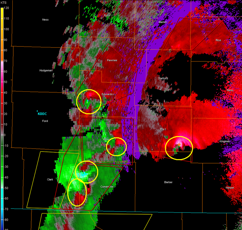
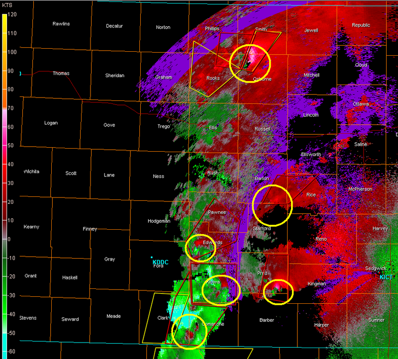
MESOSCALE DISCUSSION 0993
NWS STORM PREDICTION CENTER NORMAN OK
1033 PM CDT FRI MAY 23 2008
AREAS AFFECTED...SRN NEB...MUCH OF CENTRAL KS...ERN TX
PANHANDLE...ERN OK PANHANDLE INTO WRN OK
CONCERNING...TORNADO WATCH 342...344...
VALID 240333Z - 240430Z
THE SEVERE WEATHER THREAT FOR TORNADO WATCH 342...344...CONTINUES.
...SQUALL LINE EVOLVING INTO DISCRETE SUPERCELLS WITH INCREASING
POTENTIAL FOR TORNADOES...
REGIONAL RADARS SHOWED SQUALL LINE THAT FORMED EARLIER HAS NOW
EVOLVED INTO A BROKEN LINE OF MORE DISCRETE-TYPE SUPERCELLS
EXTENDING FROM THE NERN TX PANHANDLE TO JUST EAST OF HLC.
THERMODYNAMIC AND KINEMATIC ENVIRONMENTS REMAIN VERY FAVORABLE FOR
STRONG LONG-LIVED TORNADOES AS THIS ACTIVITY SPREADS ENEWD DURING
THE NEXT SEVERAL HOURS. AREA WIND PROFILERS AND WSR-88D VWP DATA
SHOWED MID LEVEL WINDS VEERING TO SWLY...AS INDICATED BY SHORT TERM
MODELS. THIS WILL CONTINUE TO SUPPORT THE EVOLUTION OF MORE
DISCRETE STORMS INTO THE LATE EVENING/EARLY OVERNIGHT PERIOD.
STRONG SLY LLJ FROM OK INTO KS COMBINED WITH THE VEERING MID LEVEL
WINDS WILL SUPPORT A FURTHER INCREASE IN LOW LEVEL SHEAR WITH
EFFECTIVE SRH VALUES NOW RANGING FROM 400-600 M2/S2. THIS SUPPORTS
THE POTENTIAL FOR LONG-LIVED STRONG TO VIOLENT TORNADOES.
ADDITIONAL STORM DEVELOPMENT IS EXPECTED SWD THROUGH THE ERN TX
PANHANDLE AS THE COLD FRONT CONTINUES TO SPREAD EWD OVERTAKING THE
DRY LINE. THIS TREND APPEARS LIKELY GIVEN RECENT NEW TSTM
DEVELOPMENT IN THE NERN TX PANHANDLE...AND GIVEN FAVORABLE
INSTABILITY AND STRONG EFFECTIVE BULK SHEAR FOR ORGANIZED STORMS.
..PETERS.. 05/24/2008
ATTN...WFO...OAX...TOP...ICT...OUN...GID...LBF...DDC...GLD...LUB...AMA...
34730100 35960073 37030008 38209984 38430000 39150081
39580096 39590129 40310133 40390021 40719987 40729730
40009737 40009679 39649672 38569692 38419729 38079714
37039716 36959799 36219808 35639828 35289854 34869866
34609884 34349928
0 likes
-
6SpeedTA95
- Category 5
- Posts: 1206
- Joined: Wed Oct 19, 2005 3:25 pm
- Location: Oklahoma
- Contact:
-
brunota2003

- S2K Supporter

- Posts: 9476
- Age: 35
- Joined: Sat Jul 30, 2005 9:56 pm
- Location: Stanton, KY...formerly Havelock, NC
- Contact:
SEVERE WEATHER STATEMENT
NATIONAL WEATHER SERVICE DODGE CITY KS
1038 PM CDT FRI MAY 23 2008
KSC047-145-240415-
/O.CON.KDDC.TO.W.0051.000000T0000Z-080524T0415Z/
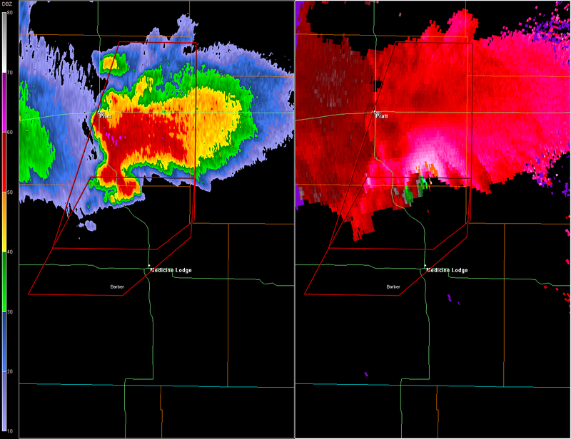
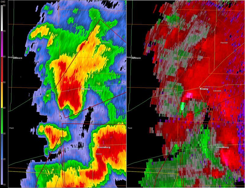
PAWNEE KS-EDWARDS KS-
1038 PM CDT FRI MAY 23 2008
...A TORNADO WARNING REMAINS IN EFFECT UNTIL 1115 PM CDT FOR NORTHERN
EDWARDS AND PAWNEE COUNTIES...
AT 1035 PM CDT...WEATHER SERVICE DOPPLER RADAR CONTINUED TO INDICATE
A SEVERE THUNDERSTORM WITH STRONG ROTATION NEAR KINSLEY...MOVING
NORTHEAST AT 40 MPH.
* LOCATIONS IMPACTED INCLUDE...
KINSLEY...
LEWIS...
GARFIELD...
ZOOK...
FRIZELL...
RURAL RESIDENCES OF NORTHERN EDWARDS AND PAWNEE COUNTIES.
THE TOWNS OF GARFIELD AND LARNED ARE IN THE PATH OF THIS TORNADO.
IN ADDITION TO THE TORNADO...THIS STORM IS CAPABLE OF PRODUCING
QUARTER SIZED HAIL AND DESTRUCTIVE STRAIGHT LINE WINDS.
Gonna be a long couple days. Got a really close friend out there who only gets on every couple days...
NATIONAL WEATHER SERVICE DODGE CITY KS
1038 PM CDT FRI MAY 23 2008
KSC047-145-240415-
/O.CON.KDDC.TO.W.0051.000000T0000Z-080524T0415Z/
PAWNEE KS-EDWARDS KS-
1038 PM CDT FRI MAY 23 2008
...A TORNADO WARNING REMAINS IN EFFECT UNTIL 1115 PM CDT FOR NORTHERN
EDWARDS AND PAWNEE COUNTIES...
AT 1035 PM CDT...WEATHER SERVICE DOPPLER RADAR CONTINUED TO INDICATE
A SEVERE THUNDERSTORM WITH STRONG ROTATION NEAR KINSLEY...MOVING
NORTHEAST AT 40 MPH.
* LOCATIONS IMPACTED INCLUDE...
KINSLEY...
LEWIS...
GARFIELD...
ZOOK...
FRIZELL...
RURAL RESIDENCES OF NORTHERN EDWARDS AND PAWNEE COUNTIES.
THE TOWNS OF GARFIELD AND LARNED ARE IN THE PATH OF THIS TORNADO.
IN ADDITION TO THE TORNADO...THIS STORM IS CAPABLE OF PRODUCING
QUARTER SIZED HAIL AND DESTRUCTIVE STRAIGHT LINE WINDS.
Gonna be a long couple days. Got a really close friend out there who only gets on every couple days...
0 likes

Return to “USA & Caribbean Weather”
Who is online
Users browsing this forum: A1A, cstrunk, SnowyOwl31, South Texas Storms and 115 guests