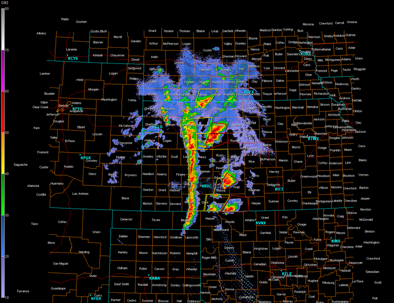
As for the northern cells, Hays is really under the gun now...
Memorial Day Weekend Outbreak 2008
Moderator: S2k Moderators
Forum rules

The posts in this forum are NOT official forecast and should not be used as such. They are just the opinion of the poster and may or may not be backed by sound meteorological data. They are NOT endorsed by any professional institution or STORM2K.

-
CrazyC83
- Professional-Met

- Posts: 34315
- Joined: Tue Mar 07, 2006 11:57 pm
- Location: Deep South, for the first time!
Re:
RL3AO wrote:Line of storms about to move through Dodge City which will pretty much eliminate the KDDC radar for use with the Ellis storm.
That's the squall line? That could play a big role in tomorrow's situation.
0 likes
-
Texas Snowman

- Storm2k Moderator

- Posts: 6197
- Joined: Fri Jan 25, 2008 11:29 am
- Location: Denison, Texas
Re: Tornado outbreak again today?
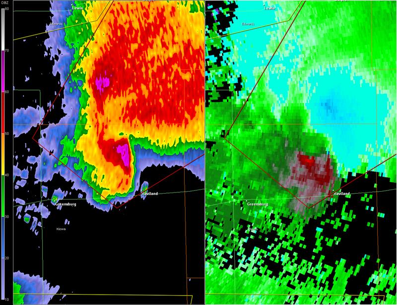
Tornado Warning remains in effect until 930 PM CDT for
northeastern Kiowa... northwestern Pratt... eastern Edwards...
southwestern Stafford and extreme southeastern Pawnee counties...
At 849 PM CDT... National Weather Service meteorologists and storm
spotters were tracking a large and extremely dangerous tornado 7
miles south of Fellsburg... or 6 miles northwest of Haviland... moving
northeast at 32 mph.
* Locations impacted include...
Centerview...
Fellsburg...
Trousdale...
Hopewell...
Belpre...
Byers...
Macksville...
rural residences of eastern Edwards... northeastern Kiowa...
northwestern Pratt... southeastern Pawnee and southwestern Stafford
counties.
At 845 PM... storm chasers reported a large tornado 3 miles west of
Haviland. Persons in the path of this dangerous tornado need to take
shelter now!
This storm is considered a supercell storm. Destructive hail the size
of baseball or larger and very dangerous straight line
winds will also be likely near the tornadic portion of this storm.
The safest place to be during a tornado is in a basement. If in a
Mobile home... evacuate to a substantial structure. Get under a
workbench or other piece of sturdy furniture. If no basement is
available... seek shelter on the lowest floor of the building in an
interior hallway or room such as a closet. Use blankets or pillows to
cover your body and always stay away from windows.
Heavy rainfall may obscure this tornado. Take cover now! If you wait
to see or hear it coming... it may be too late to get to a safe place.
Tornadoes at night are especially dangerous. Do not wait until you
see or hear the tornado... it may be too late. Take cover now!
A Tornado Watch remains in effect until 400 am CDT Saturday morning
for southwestern Kansas.
Lat... Lon 3771 9934 3804 9909 3782 9868 3759 9916
time... Mot... loc 0150z 230deg 28kt 3770 9915
Last edited by Texas Snowman on Fri May 23, 2008 9:01 pm, edited 1 time in total.
0 likes

-
6SpeedTA95
- Category 5

- Posts: 1206
- Joined: Wed Oct 19, 2005 3:25 pm
- Location: Oklahoma
- Contact:
Re: Tornado outbreak again today?
Category 5 wrote:Someone, somewhere, was watching over Greensburg tonight.
I agree...that thing got real weak, real quick and then cycled back up.
0 likes

-
CrazyC83
- Professional-Met
- Posts: 34315
- Joined: Tue Mar 07, 2006 11:57 pm
- Location: Deep South, for the first time!
Re:
Cyclenall wrote:Violent tornadoes and NIGHT don't bode well. Another large tornado is heading for that Ellis town and they don't even have power.
Ellis may very well have been devastated *prays it isn't the case*
0 likes
-
Texas Snowman
- Storm2k Moderator
- Posts: 6197
- Joined: Fri Jan 25, 2008 11:29 am
- Location: Denison, Texas
-
CrazyC83
- Professional-Met
- Posts: 34315
- Joined: Tue Mar 07, 2006 11:57 pm
- Location: Deep South, for the first time!
Re: Tornado outbreak again today?
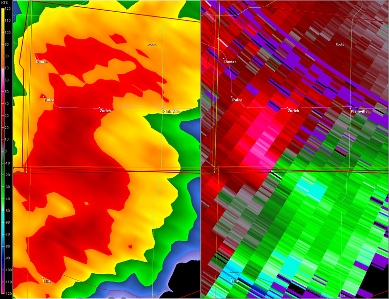
SEVERE WEATHER STATEMENT
NATIONAL WEATHER SERVICE DODGE CITY KS
900 PM CDT FRI MAY 23 2008
KSC051-195-240245-
/O.CON.KDDC.TO.W.0042.000000T0000Z-080524T0245Z/
TREGO KS-ELLIS KS-
900 PM CDT FRI MAY 23 2008
...A TORNADO WARNING REMAINS IN EFFECT UNTIL 945 PM CDT FOR NORTHERN
ELLIS AND NORTHEASTERN TREGO COUNTIES...
AT 858 PM CDT...NATIONAL WEATHER SERVICE METEOROLOGISTS AND STORM
SPOTTERS WERE TRACKING A LARGE AND EXTREMELY DANGEROUS TORNADO 2
MILES SOUTHWEST OF ELLIS...MOVING NORTHEAST AT 35 MPH.
* LOCATIONS IMPACTED INCLUDE...
ELLIS...
RURAL RESIDENCES OF NORTHEASTERN TREGO AND NORTHERN ELLIS COUNTIES.
THIS STORM HAS A HISTORY OF PRODUCING LARGE TORNADOES.
ANOTHER TORNADO WAS LOCATED IN FAR NORTHERN ELLIS COUNTY OR ABOUT
10 MILES NORTH NORTHEAST OF ELLIS AND MOVING NORTHEAST AT 30 MPH.
HEAVY RAINFALL MAY OBSCURE THIS TORNADO. TAKE COVER NOW! IF YOU WAIT
TO SEE OR HEAR IT COMING...IT MAY BE TOO LATE TO GET TO A SAFE PLACE.
THIS IS AN EXTREMELY DANGEROUS AND LIFE THREATENING SITUATION. A
LARGE TORNADO HAS BEEN CONFIRMED!. IF YOU ARE IN THE PATH OF THIS
DESTRUCTIVE TORNADO...TAKE COVER IMMEDIATELY IN A BASEMENT OR OTHER
UNDERGROUND SHELTER AND GET UNDER SOMETHING STURDY.
LAT...LON 3912 9904 3894 9914 3880 9961 3890 9972
3913 9963
TIME...MOT...LOC 0200Z 226DEG 38KT 3896 9952
$$
FINCH
0 likes
-
6SpeedTA95
- Category 5
- Posts: 1206
- Joined: Wed Oct 19, 2005 3:25 pm
- Location: Oklahoma
- Contact:
-
Texas Snowman
- Storm2k Moderator
- Posts: 6197
- Joined: Fri Jan 25, 2008 11:29 am
- Location: Denison, Texas
Re: Tornado outbreak again today?
Is that damage from first or second tornado?
Greg Forbes said very tight couplet just NE of Ellis, KS now.
Greg Forbes said very tight couplet just NE of Ellis, KS now.
0 likes
-
6SpeedTA95
- Category 5
- Posts: 1206
- Joined: Wed Oct 19, 2005 3:25 pm
- Location: Oklahoma
- Contact:
-
Texas Snowman
- Storm2k Moderator
- Posts: 6197
- Joined: Fri Jan 25, 2008 11:29 am
- Location: Denison, Texas
Return to “USA & Caribbean Weather”
Who is online
Users browsing this forum: South Texas Storms, WeatherNewbie and 88 guests