This is how it went down, it needs no introduction
viewtopic.php?f=24&t=94391&st=0&sk=t&sd=a
1 Year Ago Sunday
Moderator: S2k Moderators
Forum rules

The posts in this forum are NOT official forecast and should not be used as such. They are just the opinion of the poster and may or may not be backed by sound meteorological data. They are NOT endorsed by any professional institution or STORM2K.
-
Category 5

- Category 5

- Posts: 10074
- Age: 36
- Joined: Sun Feb 11, 2007 10:00 pm
- Location: New Brunswick, NJ
- Contact:
1 Year Ago Sunday
0 likes
-
JonathanBelles
- Professional-Met

- Posts: 11430
- Age: 35
- Joined: Sat Dec 24, 2005 9:00 pm
- Location: School: Florida State University (Tallahassee, FL) Home: St. Petersburg, Florida
- Contact:
-
vbhoutex

- Storm2k Executive

- Posts: 29149
- Age: 74
- Joined: Wed Oct 09, 2002 11:31 pm
- Location: Cypress, TX
- Contact:
Re: 1 Year Ago Sunday
I remember that night well. We did end up with major damage to the crops at the farm, but since no one lives on the farm there was no physical structure damage we had to deal with. One of the tornados that went SE of St. John tracked very close to or right over our property.
0 likes
-
brunota2003

- S2K Supporter

- Posts: 9476
- Age: 35
- Joined: Sat Jul 30, 2005 9:56 pm
- Location: Stanton, KY...formerly Havelock, NC
- Contact:
I do not know if any of you guys have been paying attention to the NWS Dodge City, KS webpage...I have a friend out there, so I'm on it quite a bit, here is their One Year Later page (WARNING: it is a .pdf)
http://www.crh.noaa.gov/images/ddc/News ... _later.pdf
There are some crazy pictures on there.
Quick fact:
Out of all the buildings in downtown Greensburg, only one was left standing after the tornado passed through. You can see that one survivor in one of the photos taken earlier in April that they have linked to.
0 likes
-
Ed Mahmoud
Re: 1 Year Ago Sunday
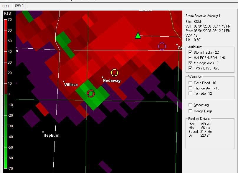
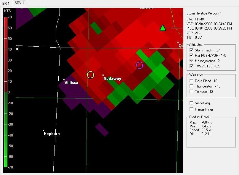
Just looking at the radar animations on the original thread. The tornado and attendant hook echo was centered on the South end of the supercell, instead of the more usual Southwest corner.
Not sure what it means, but those are eery radar animations even a year after the fact.
Not sure what it means, but those are eery radar animations even a year after the fact.
0 likes
-
simplykristi
- S2K Supporter
- Posts: 1220
- Joined: Sat May 10, 2003 1:59 pm
- Location: Near KCMO
- Contact:
Re: 1 Year Ago Sunday
Category 5 wrote:This is how it went down, it needs no introduction
viewtopic.php?f=24&t=94391&st=0&sk=t&sd=a
I remember that night well. I remember tracking the storms thru storm2k.org.
Kristi
0 likes

Re: 1 Year Ago Sunday
I still keep the Level II NEXRAD info for that night around just to look at it. The last image I posted with the doughnut of debris wrapped around the main circulation is still eerie to look at.
I've never felt so sick watching radar in my life.
--snoopj
I've never felt so sick watching radar in my life.
--snoopj
0 likes
-
JonathanBelles
- Professional-Met
- Posts: 11430
- Age: 35
- Joined: Sat Dec 24, 2005 9:00 pm
- Location: School: Florida State University (Tallahassee, FL) Home: St. Petersburg, Florida
- Contact:
Re: 1 Year Ago Sunday
snoopj wrote:I still keep the Level II NEXRAD info for that night around just to look at it. The last image I posted with the doughnut of debris wrapped around the main circulation is still eerie to look at.
I've never felt so sick watching radar in my life.
--snoopj
I have that image inplanted into my brain. I remember that night very well.
0 likes

Amazing day for all the wrong reasons really.
Here's a video (its in 3 parts) of someone who tracked the tornado, this man may well have saved a lot of lives:
http://www.youtube.com/watch?v=b6aPChg1B_g
Here's a video (its in 3 parts) of someone who tracked the tornado, this man may well have saved a lot of lives:
http://www.youtube.com/watch?v=b6aPChg1B_g
0 likes
-
tornado92

- Tropical Low

- Posts: 47
- Joined: Sun Mar 30, 2008 11:55 am
- Location: Basingstoke, Hampshire, UK
Re: 1 Year Ago Sunday
Yeah. It was in the Discovery Channel's 'Stormchasers' last year for the US and this year for the UK. They went to Greensburg and filmed the damage done by the F5. It just isn't nice when things like that happens but thats Mother Nature, you can't do a thing about it.
It was a huge tornado. Thats all I have to say.
It was a huge tornado. Thats all I have to say.
0 likes
-
Category 5
- Category 5
- Posts: 10074
- Age: 36
- Joined: Sun Feb 11, 2007 10:00 pm
- Location: New Brunswick, NJ
- Contact:
Re:
KWT wrote:Amazing day for all the wrong reasons really.
Here's a video (its in 3 parts) of someone who tracked the tornado, this man may well have saved a lot of lives:
http://www.youtube.com/watch?v=b6aPChg1B_g
Dave Freeman did save alot of lives that night. His coverage was absolutely fantastic.
0 likes
-
Category 5
- Category 5
- Posts: 10074
- Age: 36
- Joined: Sun Feb 11, 2007 10:00 pm
- Location: New Brunswick, NJ
- Contact:
Re:
brunota2003 wrote:I do not know if any of you guys have been paying attention to the NWS Dodge City, KS webpage...I have a friend out there, so I'm on it quite a bit, here is their One Year Later page (WARNING: it is a .pdf)
http://www.crh.noaa.gov/images/ddc/News ... _later.pdf
Take my advice, download the powerpoint in there. It's got great information and never before seen pics, including this one.
The bigger and never before seen Trousdale tornado.
And this haunting shot of the satellite tornadoes.
0 likes
-
brunota2003
- S2K Supporter
- Posts: 9476
- Age: 35
- Joined: Sat Jul 30, 2005 9:56 pm
- Location: Stanton, KY...formerly Havelock, NC
- Contact:
-
Category 5
- Category 5
- Posts: 10074
- Age: 36
- Joined: Sun Feb 11, 2007 10:00 pm
- Location: New Brunswick, NJ
- Contact:
-
Category 5
- Category 5
- Posts: 10074
- Age: 36
- Joined: Sun Feb 11, 2007 10:00 pm
- Location: New Brunswick, NJ
- Contact:
-
Category 5
- Category 5
- Posts: 10074
- Age: 36
- Joined: Sun Feb 11, 2007 10:00 pm
- Location: New Brunswick, NJ
- Contact:
-
Category 5
- Category 5
- Posts: 10074
- Age: 36
- Joined: Sun Feb 11, 2007 10:00 pm
- Location: New Brunswick, NJ
- Contact:
-
Category 5
- Category 5
- Posts: 10074
- Age: 36
- Joined: Sun Feb 11, 2007 10:00 pm
- Location: New Brunswick, NJ
- Contact:
Re: 1 Year Ago Sunday
SEVERE WEATHER STATEMENT
NATIONAL WEATHER SERVICE DODGE CITY KS
941 PM CDT FRI MAY 4 2007
KSC097-050300-
/O.CON.KDDC.TO.W.0025.000000T0000Z-070505T0300Z/
KIOWA KS-
941 PM CDT FRI MAY 4 2007
...A TORNADO WARNING REMAINS IN EFFECT UNTIL 1000 PM CDT FOR CENTRAL
KIOWA COUNTY...
...A TORNADO EMERGENCY FOR GREENSBURG....
AT 937 PM CDT...NATIONAL WEATHER SERVICE METEOROLOGISTS AND STORM
SPOTTERS WERE TRACKING A LARGE AND EXTREMELY DANGEROUS TORNADO. THIS
TORNADO WAS LOCATED 5 MILES SOUTH OF GREENSBURG...MOVING NORTH AT 20
MPH.
A VIOLENT TORNADO WAS ON A DIRECT PATH FOR PORTIONS OF GREENSBURG...
ESPECIALLY THE EASTERN PORTIONS OF TOWN. TAKE IMMEDIATE TORNADO
PRECATIONS...THIS IS AN EMERGENCY SITUATION FOR GREENSBURG!!
A TORNADO WATCH REMAINS IN EFFECT UNTIL 200 AM CDT SATURDAY MORNING
FOR SOUTHWESTERN KANSAS.
LAT...LON 3749 9936 3745 9929 3760 9901 3764 9936
$$
UMSCHEID
0 likes
-
Category 5
- Category 5
- Posts: 10074
- Age: 36
- Joined: Sun Feb 11, 2007 10:00 pm
- Location: New Brunswick, NJ
- Contact:
Re: 1 Year Ago Sunday
TORNADO WARNING
KSC047-097-050330-
/O.NEW.KDDC.TO.W.0026.070505T0250Z-070505T0330Z/
BULLETIN - EAS ACTIVATION REQUESTED
TORNADO WARNING
NATIONAL WEATHER SERVICE DODGE CITY KS
950 PM CDT FRI MAY 4 2007
THE NATIONAL WEATHER SERVICE IN DODGE CITY HAS ISSUED A
* TORNADO WARNING FOR...
SOUTHEASTERN EDWARDS COUNTY IN SOUTH CENTRAL KANSAS.
NORTHEASTERN KIOWA COUNTY IN SOUTH CENTRAL KANSAS.
* UNTIL 1030 PM CDT
* AT 945 PM CDT...NATIONAL WEATHER SERVICE METEOROLOGISTS WERE
TRACKING A CONFIRMED LARGE AND EXTREMELY DANGEROUS TORNADO 2 MILES
SOUTH OF GREENSBURG...MOVING NORTHEAST AT 30 MPH.
* LOCATIONS IMPACTED INCLUDE...
GREENSBURG...
CENTERVIEW...
FELLSBURG...
RURAL RESIDENCES OF NORTHEASTERN KIOWA AND SOUTHEASTERN EDWARDS
COUNTIES.
THIS INCLUDES HIGHWAY 54 BETWEEN MILE MARKERS 107 AND 117.
IN ADDITION TO THE TORNADO...THIS STORM IS CAPABLE OF PRODUCING
GOLFBALL SIZE HAIL AND DESTRUCTIVE STRAIGHT LINE WINDS.
THIS IS AN EXTREMELY DANGEROUS AND LIFE THREATENING SITUATION. A
LARGE TORNADO HAS BEEN CONFIRMED!. IF YOU ARE IN THE PATH OF THIS
DESTRUCTIVE TORNADO...TAKE COVER IMMEDIATELY IN A BASEMENT OR OTHER
UNDERGROUND SHELTER AND GET UNDER SOMETHING STURDY.
THIS WARNING REPLACES THE PREVIOUS WARNING FOR KIOWA COUNTY.
LAT...LON 3756 9933 3753 9924 3773 9898 3788 9927
$$
UMSCHEID
0 likes
Return to “USA & Caribbean Weather”
Who is online
Users browsing this forum: No registered users and 157 guests