Myanmar / TC NARGIS (TC 01B) Update: 84,500 dead

Moderator: S2k Moderators

Message
Author
User avatar
HURAKAN
Professional-Met
Professional-Met
Posts: 46086
Age: 38
Joined: Thu May 20, 2004 4:34 pm
Location: Key West, FL
Contact:

Re: Bay of Bengal: Very Severe Cyclonic Storm NARGIS (TC 01B)

#181 Postby HURAKAN » Thu May 01, 2008 3:49 pm

Image

SUBJ: TROPICAL CYCLONE 01B (NARGIS) WARNING NR 018
WTIO31 PGTW 012100
1. TROPICAL CYCLONE 01B (NARGIS) WARNING NR 018
01 ACTIVE TROPICAL CYCLONE IN NORTHIO
MAX SUSTAINED WINDS BASED ON ONE-MINUTE AVERAGE
---
WARNING POSITION:
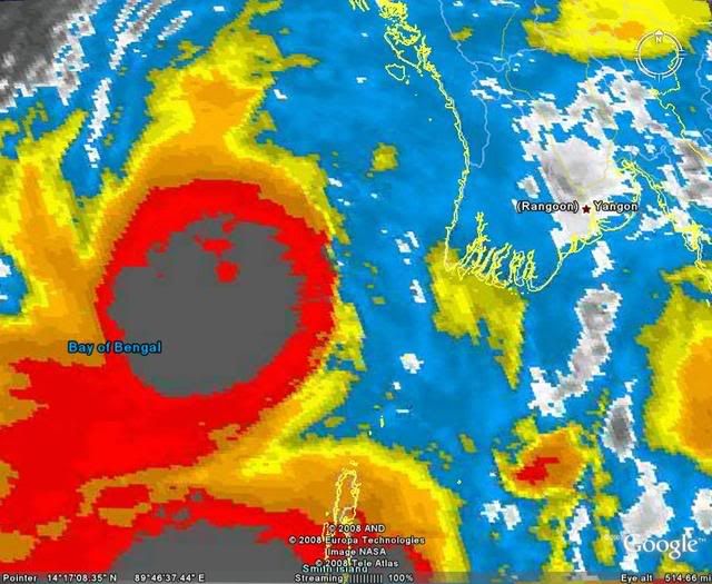
011800Z --- NEAR 15.8N 91.7E
MOVEMENT PAST SIX HOURS - 090 DEGREES AT 10 KTS
POSITION ACCURATE TO WITHIN 020 NM
POSITION BASED ON EYE FIXED BY SATELLITE
PRESENT WIND DISTRIBUTION:
MAX SUSTAINED WINDS - 110 KT, GUSTS 135 KT
WIND RADII VALID OVER OPEN WATER ONLY
RADIUS OF 064 KT WINDS - 030 NM NORTHEAST QUADRANT
030 NM SOUTHEAST QUADRANT
030 NM SOUTHWEST QUADRANT
030 NM NORTHWEST QUADRANT
RADIUS OF 050 KT WINDS - 050 NM NORTHEAST QUADRANT
050 NM SOUTHEAST QUADRANT
050 NM SOUTHWEST QUADRANT
050 NM NORTHWEST QUADRANT
RADIUS OF 034 KT WINDS - 100 NM NORTHEAST QUADRANT
120 NM SOUTHEAST QUADRANT
110 NM SOUTHWEST QUADRANT
110 NM NORTHWEST QUADRANT
REPEAT POSIT: 15.8N 91.7E
---
FORECASTS:
12 HRS, VALID AT:
020600Z --- 16.3N 93.5E
MAX SUSTAINED WINDS - 115 KT, GUSTS 140 KT
WIND RADII VALID OVER OPEN WATER ONLY
RADIUS OF 064 KT WINDS - 030 NM NORTHEAST QUADRANT
030 NM SOUTHEAST QUADRANT
030 NM SOUTHWEST QUADRANT
030 NM NORTHWEST QUADRANT
RADIUS OF 050 KT WINDS - 050 NM NORTHEAST QUADRANT
050 NM SOUTHEAST QUADRANT
050 NM SOUTHWEST QUADRANT
050 NM NORTHWEST QUADRANT
RADIUS OF 034 KT WINDS - 090 NM NORTHEAST QUADRANT
095 NM SOUTHEAST QUADRANT
100 NM SOUTHWEST QUADRANT
100 NM NORTHWEST QUADRANT
VECTOR TO 24 HR POSIT: 065 DEG/ 09 KTS
---
24 HRS, VALID AT:
021800Z --- 17.0N 95.2E
MAX SUSTAINED WINDS - 070 KT, GUSTS 085 KT
WIND RADII VALID OVER OPEN WATER ONLY
DISSIPATING AS A SIGNIFICANT TROPICAL CYCLONE OVER LAND
VECTOR TO 36 HR POSIT: 055 DEG/ 09 KTS
---
36 HRS, VALID AT:
030600Z --- 18.0N 96.7E
MAX SUSTAINED WINDS - 040 KT, GUSTS 050 KT
WIND RADII VALID OVER OPEN WATER ONLY
DISSIPATING AS A SIGNIFICANT TROPICAL CYCLONE OVER LAND
VECTOR TO 48 HR POSIT: 050 DEG/ 08 KTS
---
EXTENDED OUTLOOK:
48 HRS, VALID AT:
031800Z --- 19.1N 98.0E
MAX SUSTAINED WINDS - 025 KT, GUSTS 035 KT
WIND RADII VALID OVER OPEN WATER ONLY
DISSIPATED AS A SIGNIFICANT TROPICAL CYCLONE OVER LAND
---
REMARKS:
012100Z POSITION NEAR 15.9N 92.2E.
MAXIMUM SIGNIFICANT WAVE HEIGHT AT 011800Z IS 28 FEET.
NEXT WARNINGS AT 020300Z, 020900Z, 021500Z AND 022100Z.
_______________________________________________________

If this track becomes a reality, the storm surge through the Irrawaddy delta region would be of catastrophic proportions.
0 likes   

User avatar
KWT
Category 5
Category 5
Posts: 31415
Joined: Tue Aug 17, 2004 11:02 am
Location: UK!!!

#182 Postby KWT » Thu May 01, 2008 3:54 pm

Yep and also if the forecast strength is correct we are going to have a very powerful system making landfall, 115kts is extremely dangerous!
0 likes   

CrazyC83
Professional-Met
Professional-Met
Posts: 34002
Joined: Tue Mar 07, 2006 11:57 pm
Location: Deep South, for the first time!

#183 Postby CrazyC83 » Thu May 01, 2008 4:00 pm

01/2030 UTC 15.8N 92.1E T5.5/6.0 NARGIS -- Bay of Bengal

Eyewall cycle underway?
0 likes   

CrazyC83
Professional-Met
Professional-Met
Posts: 34002
Joined: Tue Mar 07, 2006 11:57 pm
Location: Deep South, for the first time!

Re: Bay of Bengal: Very Severe Cyclonic Storm NARGIS (TC 01B)

#184 Postby CrazyC83 » Thu May 01, 2008 4:01 pm

HURAKAN wrote:If this track becomes a reality, the storm surge through the Irrawaddy delta region would be of catastrophic proportions.


The sharp turn in the coast to the south looks like that any deviation to the south would bring up a monster storm surge to that area...
0 likes   

User avatar
KWT
Category 5
Category 5
Posts: 31415
Joined: Tue Aug 17, 2004 11:02 am
Location: UK!!!

#185 Postby KWT » Thu May 01, 2008 4:05 pm

Interesting crazy I sure hope that it is undergoing some sort of structual issues though not sure what they may be right now. Also yeah any slight southward track will allow a strong surge to push up the bay.
0 likes   

User avatar
Pedro Fernández
Tropical Storm
Tropical Storm
Posts: 233
Age: 47
Joined: Mon Dec 31, 2007 7:24 am
Location: Costa Tropical (Granada, Spain).
Contact:

Re: Re:

#186 Postby Pedro Fernández » Thu May 01, 2008 4:08 pm

HURAKAN wrote:
Pedro Fernández wrote:Wow... Incredible............. I had never thought NARGIS could became so strong !! :eek: :eek:


It seems that what most affected Nargis was the fact that was almost stationary for 24 hours and upwelling brought to the surface cold water. Right after the storm began to move, its organization improved dramatically.


Maybe, Hurakan... Windshear is only a little bit lower than before......................... Then, I can't think in other reason. It seems forecasts models have been wrong.... :double:
0 likes   

User avatar
HURAKAN
Professional-Met
Professional-Met
Posts: 46086
Age: 38
Joined: Thu May 20, 2004 4:34 pm
Location: Key West, FL
Contact:

#187 Postby HURAKAN » Thu May 01, 2008 4:14 pm

Image

For our benefit, sunrise is about three hours or so away from Myanmar and we should have visible images of the landfall.
0 likes   

Derek Ortt

#188 Postby Derek Ortt » Thu May 01, 2008 4:40 pm

IMD wont go higher because their BS satellite only has an 8km resolution.

If you cannot see the eye on a 4km resolution, you are most certainly not going to see it with an 8 km resolution
0 likes   

User avatar
KWT
Category 5
Category 5
Posts: 31415
Joined: Tue Aug 17, 2004 11:02 am
Location: UK!!!

#189 Postby KWT » Thu May 01, 2008 4:43 pm

Well if thats the case Derek then some people are in for a very rude awakening, also makes the prospect of recon in the N.Indian ocean quite scary if they hold this at 65kts!
0 likes   

RL3AO
Moderator-Pro Met
Moderator-Pro Met
Posts: 16308
Joined: Thu Jun 14, 2007 10:03 pm
Location: NC

#190 Postby RL3AO » Thu May 01, 2008 4:44 pm

They (IMD) should check out the NRL and SSD. :D
0 likes   

User avatar
P.K.
Professional-Met
Professional-Met
Posts: 5149
Joined: Thu Sep 23, 2004 5:57 pm
Location: Watford, England
Contact:

Re: Bay of Bengal: Very Severe Cyclonic Storm NARGIS (TC 01B)

#191 Postby P.K. » Thu May 01, 2008 5:22 pm

Well they have raised it to 75kts but that is still well below the sat estimates from KNES and PGTW.

RSMC- TROPICAL CYCLONES, NEW DELHI


TROPCAL STORM “NARGIS” ADVISORY NO. THIRTY ONE ISSUED AT 2100 UTC OF 1 MAY 2008 BASED ON 1800 UTC CHARTS OF 1 MAY 2008.


THE VERY SEVERE CYCLONIC STORM “NARGIS” OVER EASTCENTRAL BAY OF BENGAL MOVED EASTWARDS AND LAY CENTRED AT 1800 UTC OF 1 MAY 2008 OVER EASTCENTRAL BAY OF BENGAL NEAR LAT. 16.00 N AND LONG 91.50 E, ABOUT 400 KM SOUTHWEST OF SANDOWAY (48080). CURRENT INTENSITY IS T4.0 RPT T4.0. MAXIMUM SUSTAINED SURFACE WIND SPEED IS 75 KTS. SEA CONDITION IS PHENOMENAL AROUND THE SYSTEM CENTRE. ESTIMATED CENTRAL PRESSURE IS 980 HPA. SATELLITE IMAGERY SHOWS BROKEN TO SOLID INTENSE TO VERY INTENSE CONVECTIVE CLOUDS BETWEEN LATITUDE 11.00 TO 18.50 NORTH AND LONG 88.00 TO 93.50 EAST IN ASSOCIATION WITH THE SYSTEM.


FORECAST: THE SYSTEM IS LIKELY TO MOVE IN A EAST-NORTHEASTERLY DIRECTION AND CROSS MYANMAR COAST AROUND 170 N BY 1200 AND 1800 UTC OF 2ND MAY 2008. FORECAST INTENSITY AT 021500 UTC IS T5.0 RPT T5.0.
0 likes   

Derek Ortt

#192 Postby Derek Ortt » Thu May 01, 2008 5:25 pm

their website also does not exactly work 24/7, including during major landfall events
0 likes   

User avatar
Cyclenall
Category 5
Category 5
Posts: 6666
Joined: Thu Jun 08, 2006 10:01 pm
Location: Ontario, Canada

Re:

#193 Postby Cyclenall » Thu May 01, 2008 5:36 pm

I knew this had the potential for this, it was just a matter of time. One model got the strength correct 4 days ago. It is also the time of the year that is favorable for the northern Indian basin cyclones to ramp up rapidly. Looks to be a category 4 cyclone.

HURAKAN wrote:Image

Where are you getting those NOAA floater images of the Cyclone from? I didn't know there was any for the northern Indian basin.
0 likes   

RL3AO
Moderator-Pro Met
Moderator-Pro Met
Posts: 16308
Joined: Thu Jun 14, 2007 10:03 pm
Location: NC

Re: Re:

#194 Postby RL3AO » Thu May 01, 2008 5:42 pm

Cyclenall wrote:Where are you getting those NOAA floater images of the Cyclone from? I didn't know there was any for the northern Indian basin.


http://www.ssd.noaa.gov/PS/TROP/mtsatfloat1.html
0 likes   

User avatar
Cyclenall
Category 5
Category 5
Posts: 6666
Joined: Thu Jun 08, 2006 10:01 pm
Location: Ontario, Canada

#195 Postby Cyclenall » Thu May 01, 2008 6:34 pm

So Nargis just happened to get east enough for the MTSAT to track it?
0 likes   

User avatar
Tampa Bay Hurricane
Category 5
Category 5
Posts: 5597
Age: 37
Joined: Fri Jul 22, 2005 7:54 pm
Location: St. Petersburg, FL

#196 Postby Tampa Bay Hurricane » Thu May 01, 2008 7:39 pm

http://www.wunderground.com/tropical
Nargis at 125 mph a Potent Category 3. This may briefly
hit Category 4.
0 likes   

Derek Ortt

#197 Postby Derek Ortt » Thu May 01, 2008 8:10 pm

http://www.nrlmry.navy.mil/tc_pages/tc0 ... atest.html

The eye is more than fine

This is likely an upper cat 4 or a lower cat 5, but due to the eye size, the IR is having a little trouble detecting the eye. It is surrounded by cloud top temps of <193K
0 likes   

User avatar
HURAKAN
Professional-Met
Professional-Met
Posts: 46086
Age: 38
Joined: Thu May 20, 2004 4:34 pm
Location: Key West, FL
Contact:

#198 Postby HURAKAN » Thu May 01, 2008 8:37 pm

Image

Image

The eye is a few hours from land.
0 likes   

Derek Ortt

#199 Postby Derek Ortt » Thu May 01, 2008 8:47 pm

if it moves due east, it will pass south of the delta
0 likes   

User avatar
HURAKAN
Professional-Met
Professional-Met
Posts: 46086
Age: 38
Joined: Thu May 20, 2004 4:34 pm
Location: Key West, FL
Contact:

#200 Postby HURAKAN » Thu May 01, 2008 8:51 pm

Image

Image
0 likes   


Return to “2008”

Who is online

Users browsing this forum: No registered users and 9 guests