Hybrid system off SE Coast?

U.S. & Caribbean Weather Discussions and Severe Weather Events

Moderator: S2k Moderators

Forum rules

The posts in this forum are NOT official forecast and should not be used as such. They are just the opinion of the poster and may or may not be backed by sound meteorological data. They are NOT endorsed by any professional institution or STORM2K.

Help Support Storm2K
Message
Author
Ed Mahmoud

Hybrid system off SE Coast?

#1 Postby Ed Mahmoud » Mon Apr 14, 2008 9:43 pm

OK, this is in USA Weather, because it is April, and per the new WRF, still has an area of low pressure at the 300 mb level. But the forecast circular low is looking darned circular, and I'm wondering if anyone wants to weight in on the odds (metaphysically and certainly zero, none, or just very slim) that some kind of hybrid system may form off the SE Coast.

Image

Image


The board seems slow, even a hint of model watching should liven things up.


Edit to add surface map.
0 likes   

Ed Mahmoud

Re: Hybrid system off SE Coast?

#2 Postby Ed Mahmoud » Tue Apr 15, 2008 7:51 am

The Canadian has a slightly interesting look, with the 10ºC 850 mb isotherm around the low between the 0ºC to the North and the continuous 10ºC to the South.

Image


CMC almost (not quite) takes this warm core.
Image

GFS looks similar to CMC, UK Met is solidly cold core, NOGAPS is cold core becoming asymetrically warm core.
Image
0 likes   

Ed Mahmoud

Re: Hybrid system off SE Coast?

#3 Postby Ed Mahmoud » Tue Apr 15, 2008 7:56 am

Winter like cold air strato-cu following the low offshore as nippy air moves over warmer water, a fairly reliable indicator that this thread does belong in USA Weather and not the tropics thread. At least not any time soon.
0 likes   

CrazyC83
Professional-Met
Professional-Met
Posts: 34002
Joined: Tue Mar 07, 2006 11:57 pm
Location: Deep South, for the first time!

#4 Postby CrazyC83 » Tue Apr 15, 2008 8:51 am

Looks like it should remain extratropical, at least from my view.
0 likes   

User avatar
btangy
Professional-Met
Professional-Met
Posts: 758
Joined: Fri Sep 19, 2003 11:06 pm
Location: Boulder, CO
Contact:

Re:

#5 Postby btangy » Tue Apr 15, 2008 10:09 am

CrazyC83 wrote:Looks like it should remain extratropical, at least from my view.


Agreed. It usually takes at least a few days for these type of systems to become subtropical. It won't have enough time.
0 likes   

Ed Mahmoud

Re: Re:

#6 Postby Ed Mahmoud » Tue Apr 15, 2008 10:13 am

btangy wrote:
CrazyC83 wrote:Looks like it should remain extratropical, at least from my view.


Agreed. It usually takes at least a few days for these type of systems to become subtropical. It won't have enough time.


But don't you think it is kind of cool that I took the WRF, of all models, and started a model watch thread?
0 likes   

User avatar
HURAKAN
Professional-Met
Professional-Met
Posts: 46086
Age: 38
Joined: Thu May 20, 2004 4:34 pm
Location: Key West, FL
Contact:

#7 Postby HURAKAN » Tue Apr 15, 2008 12:51 pm

Image
0 likes   

User avatar
HURAKAN
Professional-Met
Professional-Met
Posts: 46086
Age: 38
Joined: Thu May 20, 2004 4:34 pm
Location: Key West, FL
Contact:

#8 Postby HURAKAN » Tue Apr 15, 2008 1:27 pm

Image

Interesting system.
0 likes   

RL3AO
Moderator-Pro Met
Moderator-Pro Met
Posts: 16308
Joined: Thu Jun 14, 2007 10:03 pm
Location: NC

#9 Postby RL3AO » Tue Apr 15, 2008 4:00 pm

Even if it doesn't have a chance, this becoming 90L would really make S2K a lot more interesting for a few hours at least.
Last edited by RL3AO on Tue Apr 15, 2008 4:10 pm, edited 1 time in total.
0 likes   

User avatar
HURAKAN
Professional-Met
Professional-Met
Posts: 46086
Age: 38
Joined: Thu May 20, 2004 4:34 pm
Location: Key West, FL
Contact:

#10 Postby HURAKAN » Tue Apr 15, 2008 4:07 pm

Image

Even if it doesn't become 90L, it looks very interesting and it's over the GS.
0 likes   

User avatar
tigergirl
S2K Supporter
S2K Supporter
Posts: 59
Age: 55
Joined: Fri May 25, 2007 7:12 pm
Location: Larose,LA

Re: Hybrid system off SE Coast?

#11 Postby tigergirl » Tue Apr 15, 2008 5:12 pm

Cool sat pic! Wouldn't it be something if it did though. Didn't we start off early last year?
0 likes   

RL3AO
Moderator-Pro Met
Moderator-Pro Met
Posts: 16308
Joined: Thu Jun 14, 2007 10:03 pm
Location: NC

Re: Hybrid system off SE Coast?

#12 Postby RL3AO » Tue Apr 15, 2008 5:14 pm

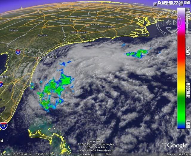
tigergirl wrote:Cool sat pic! Wouldn't it be something if it did though. Didn't we start off early last year?


Yeah. May 9.
0 likes   

User avatar
Tampa Bay Hurricane
Category 5
Category 5
Posts: 5597
Age: 37
Joined: Fri Jul 22, 2005 7:54 pm
Location: St. Petersburg, FL

#13 Postby Tampa Bay Hurricane » Tue Apr 15, 2008 5:44 pm

Way too cold for anything tropical. Most likely a Cold Core
Low will take shape. The winds are cold, with 60s temperature and
gusts of 30-35 mph easily, occasionally 40 mph is possible near the open
water I am sure. But this is probably going to be a cold core
gale center. The AIR temperatures are way TOO cold for anything remotely tropical
or subtropical to form.
0 likes   

RL3AO
Moderator-Pro Met
Moderator-Pro Met
Posts: 16308
Joined: Thu Jun 14, 2007 10:03 pm
Location: NC

Re:

#14 Postby RL3AO » Tue Apr 15, 2008 5:59 pm

Tampa Bay Hurricane wrote:Way too cold for anything tropical. Most likely a Cold Core.


Hence the reason it is in USA Weather and not Talking Tropics.
0 likes   

User avatar
HURAKAN
Professional-Met
Professional-Met
Posts: 46086
Age: 38
Joined: Thu May 20, 2004 4:34 pm
Location: Key West, FL
Contact:

#15 Postby HURAKAN » Tue Apr 15, 2008 6:28 pm

Image
0 likes   

JonathanBelles
Professional-Met
Professional-Met
Posts: 11430
Age: 35
Joined: Sat Dec 24, 2005 9:00 pm
Location: School: Florida State University (Tallahassee, FL) Home: St. Petersburg, Florida
Contact:

#16 Postby JonathanBelles » Tue Apr 15, 2008 6:35 pm

Im glad that rain isnt inland. It would be a very raw day in Florida.
0 likes   

User avatar
brunota2003
S2K Supporter
S2K Supporter
Posts: 9476
Age: 34
Joined: Sat Jul 30, 2005 9:56 pm
Location: Stanton, KY...formerly Havelock, NC
Contact:

#17 Postby brunota2003 » Tue Apr 15, 2008 7:23 pm

Was looking through the buoy reports. Most are between 20 and 25 knots, but a few are registering sustained winds of up to 30 knots. One here off the NC coast even reported winds of 33 knots for 3 straight hours, with gusts to 40 knots. Definitely some strong winds out there.

http://www.ndbc.noaa.gov/station_page.php?station=41025
0 likes   

User avatar
wall_cloud
Professional-Met
Professional-Met
Posts: 401
Age: 48
Joined: Sun Dec 04, 2005 7:32 am
Location: Bartlett, TN
Contact:

#18 Postby wall_cloud » Tue Apr 15, 2008 9:46 pm

shoot, we had sustained winds of 30 to 35 mph today with our surface low (lee trof). That said, I think there is too much baroclinicity to be a subtropical system. this is a cold core extra tropical cyclone folks. SSTs are a few degrees too low, although subtropical lows can develop at slightly cooler temps than tropical systems.
0 likes   

User avatar
Category 5
Category 5
Category 5
Posts: 10074
Age: 35
Joined: Sun Feb 11, 2007 10:00 pm
Location: New Brunswick, NJ
Contact:

Re: Hybrid system off SE Coast?

#19 Postby Category 5 » Tue Apr 15, 2008 10:53 pm

Ed Mahmoud wrote:The Canadian has a slightly interesting look, with the 10ºC 850 mb isotherm around the low between the 0ºC to the North and the continuous 10ºC to the South.

Image


CMC almost (not quite) takes this warm core.
Image

GFS looks similar to CMC, UK Met is solidly cold core, NOGAPS is cold core becoming asymetrically warm core.
Image


I've highlighted key words.

The CMC and the GFS are absolute crap at predicting even a few days out, especially in April. I wouldn't get worried, enjoy this quiet while it lasts.
0 likes   

User avatar
HURAKAN
Professional-Met
Professional-Met
Posts: 46086
Age: 38
Joined: Thu May 20, 2004 4:34 pm
Location: Key West, FL
Contact:

#20 Postby HURAKAN » Wed Apr 16, 2008 7:15 am

Image
0 likes   


Return to “USA & Caribbean Weather”

Who is online

Users browsing this forum: cheezyWXguy, TomballEd and 28 guests