
Anyway...
Moderator: S2k Moderators


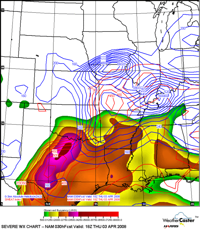
Ed Mahmoud wrote:In favor of severe weather is strong deep layer shear, and high instability. Low level winds a tad weak, which might limit tornado thread a little, per latest WRF.
Maybe more of a gusty wind and hail threat than tornadoes, if surface winds do stay light. 7 pm forecast sounding for DFW
AREA FORECAST DISCUSSION
NATIONAL WEATHER SERVICE FORT WORTH TX
940 PM CDT WED APR 2 2008
.PUBLIC FORECAST DISCUSSION...
THE MODELS CURRENTLY DEPICT THAT THE BEST COMBINATION OF SHEAR AND
INSTABILITY (USING THE ENERGY/HELICITY INDEX (OR EHI) IS PINNING THE
GREATEST TORNADO THREAT TOMORROW AFTERNOON TO BE NEAR THE RED
RIVER...FROM JUST NORTHWEST OF FORT WORTH EASTWARD INTO NORTHEAST
TEXAS...NORTHEAST OF DALLAS. (THE EHI, SHORT FOR ENERGY/HELICITY
INDEX) COMBINES INSTABILITY WITH VERTICAL WIND SHEAR....THE TWO
MOST IMPORTANT PARAMETERS FOR TORNADOES.)
THINGS ARE LIABLE TO CHANGE IN THE NEXT 24 HOURS...BUT THIS DATA
REALLY STANDS OUT NOW.
NEGATIVES? YES. THE SURFACE LOW PRESSURE SYSTEM THAT WILL BE IN THE
VICINITY OF CHILDRESS OR LUBBOCK IS NOT SHOWING A REAL STRONG
PRESSURE GRADIENT TOMORROW TO ITS EAST...THUS...THE PRESSURE
GRADIENT EAST OF THE SURFACE LOW IS NOT REAL TIGHT IN THE MODELS`
FORECAST.
HOWEVER...THINGS WILL CHANGE OVERNIGHT....AND THIS INFORMATION COULD
BECOME OBVIATED BY TOMORROW`S DATA.
ALL IN ALL...THERE IS A SIGNIFICANT CHANCE OF SEVERE WEATHER
THURSDAY.


TxWxFrisco wrote:I live in Collin County, just north of Dallas... If it gets bad before dark I will take and post some pics... Seems like just a couple of days ago we had the tordano sirens blaring and a wall cloud moving over my neighborhood... Oh wait, we did... on Monday...lol
Here we go again!

Ed Mahmoud wrote:Tampa Bay Hurricane wrote:Ed if you get any wild storm pics on camera...that would rock!!!!
I'm in Houston, where thunderstorms are fairly common, but severe weather is rare, and usually, for some reason, happens well after sunset.
CrazyC83 wrote:Not enough consensus for an upgrade - I expect it to remain a moderate risk at 0600Z.
CrazyC83 wrote:Not enough consensus for an upgrade - I expect it to remain a moderate risk at 0600Z.
Ed Mahmoud wrote:My sister and brother in law used to live in Plano, when they worked at GE in Richardson. Or vice versa. About 15 years ago now. Don't know if it has been improved, but US 75 heading up that way from Dallas was like driving in Houston.
Had a few beers in Plano.
Get the video camera out now, and check the batteries, and bring to the office.

RL3AO wrote:CrazyC83 wrote:Not enough consensus for an upgrade - I expect it to remain a moderate risk at 0600Z.
They almost never upgrade at 0600 anyway, no matter what the conditions. At least it seems that way.
Return to “USA & Caribbean Weather”
Users browsing this forum: Brent and 154 guests