BoB: Very Severe Cyclonic Storm SIDR

Moderator: S2k Moderators

Message
Author
User avatar
btangy
Professional-Met
Professional-Met
Posts: 758
Joined: Fri Sep 19, 2003 11:06 pm
Location: Boulder, CO
Contact:

Re: Bay of Bengal: Very Severe Cyclonic Storm SIDR 0709

#301 Postby btangy » Wed Nov 14, 2007 10:07 am

ADT (CIMSS) estimates are now at the highest they've been for the history of the storm.

CI# /Pressure/ Vmax
6.8 / 904.4mb/134.8kt


Given the incredible TRMM overpass earlier showing a solid and intense eyewall, Sidr is likely a Cat 5.

Upper level westerlies do increase N of the system, and this may help push some drier air in to the core as the system continues to move poleward, especially below the strong outflow layer. However, offsetting this is the huge thermodynamic potency of this region. STIPS weakens the system much too quickly, while the GFDN only weakens Sidr slowly (~10knots before landfall) and the CHIPS holds Sidr steady. I do feel Sidr has likely peaked in intensity, but echo sentiments that this will still be a historically destructive cyclone for Bangladesh.
0 likes   

Sanibel
Category 5
Category 5
Posts: 10375
Joined: Mon Aug 30, 2004 11:06 pm
Location: Offshore SW Florida

Re: Bay of Bengal: Very Severe Cyclonic Storm SIDR 0709

#302 Postby Sanibel » Wed Nov 14, 2007 10:11 am

Somebody has to be wrong there. If it is 130KTS and they are reporting 90-100KTS someone needs to be reviewed as far as competency and certification.

Sidr is maintaining tropical moisture from its south and east quadrants, dragging the tropical airmass it is feeding from with it. So far it hasn't ingested the dry air to its west. That "dry air" is at the 15 latitude and well into the tropics, so it isn't like CONUS dry air.

I read a National Geographic article on the 1970 cyclone. Since then they have built elevated concrete storm shelters along the coast. Looks like they are going to put them to use this time. Can't understand why eye hasn't blown clear at that intensity?
0 likes   

User avatar
HURAKAN
Professional-Met
Professional-Met
Posts: 46086
Age: 38
Joined: Thu May 20, 2004 4:34 pm
Location: Key West, FL
Contact:

Re: Bay of Bengal: Very Severe Cyclonic Storm SIDR 0709

#303 Postby HURAKAN » Wed Nov 14, 2007 10:14 am

Image

Image
0 likes   

User avatar
btangy
Professional-Met
Professional-Met
Posts: 758
Joined: Fri Sep 19, 2003 11:06 pm
Location: Boulder, CO
Contact:

Re: Bay of Bengal: Very Severe Cyclonic Storm SIDR 0709

#304 Postby btangy » Wed Nov 14, 2007 10:20 am

Sanibel wrote:If it is 130KTS and they are reporting 90-100KTS someone needs to be reviewed as far as competency and certification.


I agree the IMD has had a severe lag and perhaps needs a cold splash of water down their pants, but I think they use a 10min average wind in this region of the world. I'm not entirely sure what the standard reduction is from the 2min average that we're used to in the Atlantic. Perhaps someone knowledgeable in this topic can chime in.
0 likes   

User avatar
btangy
Professional-Met
Professional-Met
Posts: 758
Joined: Fri Sep 19, 2003 11:06 pm
Location: Boulder, CO
Contact:

Re: Bay of Bengal: Very Severe Cyclonic Storm SIDR 0709

#305 Postby btangy » Wed Nov 14, 2007 10:24 am

Image

There's a lot of dry air waiting in the wings, especially at mid-levels. The issue is that can it get in to Sidr? So far, it hasn't or has been completely offset by the strong surface fluxes.
0 likes   

Coredesat

Re: Bay of Bengal: Very Severe Cyclonic Storm SIDR 0709

#306 Postby Coredesat » Wed Nov 14, 2007 10:25 am

btangy wrote:
Sanibel wrote:If it is 130KTS and they are reporting 90-100KTS someone needs to be reviewed as far as competency and certification.


I agree the IMD has had a severe lag and perhaps needs a cold splash of water down their pants, but I think they use a 10min average wind in this region of the world. I'm not entirely sure what the standard reduction is from the 2min average that we're used to in the Atlantic. Perhaps someone knowledgeable in this topic can chime in.


That's partially right; IMD is fairly strange in that when they make estimates of max winds, they use a 3-minute average. If their advisory winds are based on surface obs, however, they use a 10-minute average. The bad thing here is that IMD does not distinguish between them in any way. 3-minute average winds appear to be only slightly lower than 1-minute winds, as opposed to 10-minute winds appearing to be about 88% lower.

The US agencies (NHC, CPHC, JTWC) use a 1-minute average, not 2-minute.

Even 90-100 kt 10-minute doesn't equate to 130 kt 1-min (90-100 kt 10-minute is only 105-115 kt 1-minute).
Last edited by Coredesat on Wed Nov 14, 2007 10:27 am, edited 1 time in total.
0 likes   

User avatar
HURAKAN
Professional-Met
Professional-Met
Posts: 46086
Age: 38
Joined: Thu May 20, 2004 4:34 pm
Location: Key West, FL
Contact:

#307 Postby HURAKAN » Wed Nov 14, 2007 10:26 am

Image

Impact expected in the next 36 hours.
0 likes   

User avatar
btangy
Professional-Met
Professional-Met
Posts: 758
Joined: Fri Sep 19, 2003 11:06 pm
Location: Boulder, CO
Contact:

Re: Bay of Bengal: Very Severe Cyclonic Storm SIDR 0709

#308 Postby btangy » Wed Nov 14, 2007 10:28 am

Coredesat wrote:
btangy wrote:
Sanibel wrote:If it is 130KTS and they are reporting 90-100KTS someone needs to be reviewed as far as competency and certification.


I agree the IMD has had a severe lag and perhaps needs a cold splash of water down their pants, but I think they use a 10min average wind in this region of the world. I'm not entirely sure what the standard reduction is from the 2min average that we're used to in the Atlantic. Perhaps someone knowledgeable in this topic can chime in.


That's partially right; IMD is fairly strange in that when they make estimates of max winds, they use a 3-minute average. If their advisory winds are based on surface obs, however, they use a 10-minute average. The bad thing here is that IMD does not distinguish between them in any way.

The US agencies (NHC, CPHC, JTWC) use a 1-minute average, not 2-minute.

Even 90-100 kt 10-minute doesn't equate to 130 kt 1-min (90-100 kt 10-minute is only 105-115 kt 1-minute).


Thanks Coredesat. I meant to say 1 minute for the NHC. The NWS uses 2 minute winds for surface obs. Oi... guess we've never heard of standardization.
0 likes   

Coredesat

#309 Postby Coredesat » Wed Nov 14, 2007 10:29 am

Models seem to be unanimous into Bangladesh at this point (check second post for the 06Z models).
0 likes   

Coredesat

#310 Postby Coredesat » Wed Nov 14, 2007 10:29 am

Well, there is a standard (10-minute average), the US and the IMD just don't meet it. ;)
0 likes   

Derecho
Category 5
Category 5
Posts: 1011
Joined: Sat Mar 15, 2003 3:15 pm

Re: Bay of Bengal: Very Severe Cyclonic Storm SIDR 0709

#311 Postby Derecho » Wed Nov 14, 2007 10:33 am

Sanibel wrote: I read a National Geographic article on the 1970 cyclone. Since then they have built elevated concrete storm shelters along the coast. Looks like they are going to put them to use this time.


They shelters can only house 10% of the at-risk population.


http://www.climatestabilization.org/PDF/Bangladesh.pdf
0 likes   

User avatar
HURAKAN
Professional-Met
Professional-Met
Posts: 46086
Age: 38
Joined: Thu May 20, 2004 4:34 pm
Location: Key West, FL
Contact:

Re: Bay of Bengal: Very Severe Cyclonic Storm SIDR 0709

#312 Postby HURAKAN » Wed Nov 14, 2007 10:36 am

Image
0 likes   

User avatar
Chacor
Category 5
Category 5
Posts: 10229
Joined: Mon Oct 02, 2006 10:43 pm
Location: Singapore

#313 Postby Chacor » Wed Nov 14, 2007 11:04 am

Will write an unofficial advisory in a few minutes once I get all my info ready.
0 likes   

CrazyC83
Professional-Met
Professional-Met
Posts: 34002
Joined: Tue Mar 07, 2006 11:57 pm
Location: Deep South, for the first time!

#314 Postby CrazyC83 » Wed Nov 14, 2007 11:12 am

I'd say this very well might be a Cat 5. I think that if they flew Hurricane Hunters into this, they'd find 140 kt winds and a pressure around 910mb.
0 likes   

User avatar
WindRunner
Category 5
Category 5
Posts: 5806
Age: 34
Joined: Fri Jul 29, 2005 8:07 pm
Location: Warrenton, VA, but Albany, NY for school
Contact:

#315 Postby WindRunner » Wed Nov 14, 2007 11:16 am

Even more perfect than that IR HURAKAN posted from three hours prior to this . . .

Image
0 likes   

User avatar
badkhan
Tropical Depression
Tropical Depression
Posts: 74
Age: 38
Joined: Sun Jul 29, 2007 5:06 am
Location: Karachi

Re: Bay of Bengal: Very Severe Cyclonic Storm SIDR 0709

#316 Postby badkhan » Wed Nov 14, 2007 11:19 am

SIDR advances closer to coast; Great danger signals 10 for Mongla, 9 for Ctg, Cox’s Bazar
UNB, Dhaka

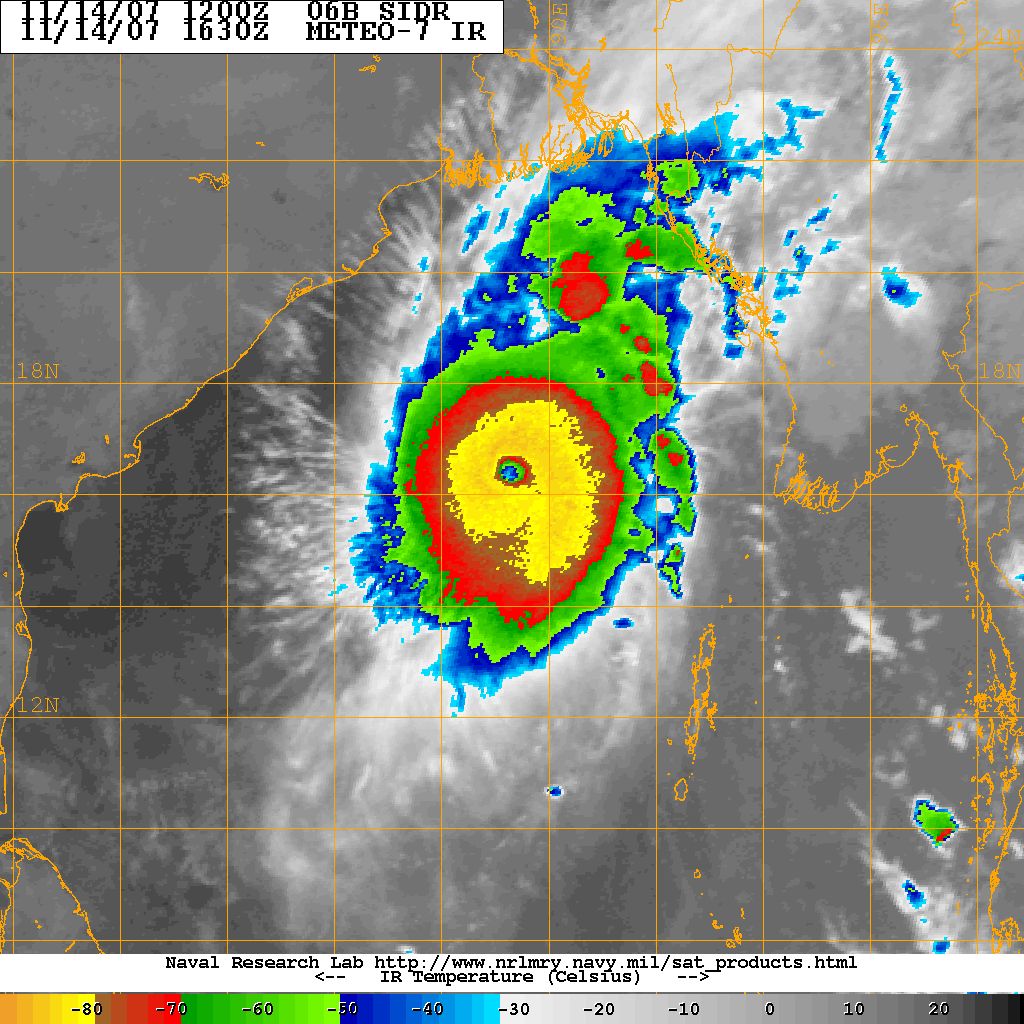
The severe cyclonic storm codenamed SIDR with a core of hurricane winds advanced closer to the country’s southern coast this evening as the seaports hoisted “great danger” signal No 10, the highest warning from the meteorologists.

A latest Met Office special bulletin said great danger signal No 10 was advised to hoist for Mongla seaport while great danger signal No 9 for Chittagong and Cox’s Bazar seaports.

The bulletin said the storm over east central bay and adjoining area moved northwards and intensified further on its way towards the coast.

“It is likely to intensify further and move in a northerly direction and may cross southern Khulna-Barisal coast by tomorrow noon,” warned the Met Office in its bulletin.

The cyclone of hurricane intensity was centered at about 755 kms south-southwest of Chittagong port, 675 kms south-southwest of Cox’s Bazar port and 705 kms south of Mongla port at 6pm.

Maximum sustained wind speed within 74 kms of the storm centre is about 190 kph, rising as high as 210 kph in gusts or squalls. “Sea will remain very high,” the Met Office warned.

Under the influence of the cyclone, the coastal districts of Cox’s Bazar, Chittagong, Noakhali, Laxmipur, Bhola, Patuakhali, Barisal, Chandpur, Barguna, Pirojpur, Jhalakati, Bagerhat, Khulna, Satkhira and their offshore islands and chars are likely to experience gusty or squally wind at a speed of 60-80 kph or more.

“The low-lying areas of these coastal districts are likely to be inundated by storm surge of 8-10 feet height above normal astronomical tide,” said the note of warning, as volunteers already started evacuating people from the coastal localities.

All fishing-boats and trawlers over the North Bay have been advised to remain in shelter until further notice.

Meanwhile, the government has directed all volunteers in the coastal districts to remain alert in view of the advancing violent storm.

A control room has been opened at the Food and Disaster Management Ministry for round-the-clock collection of information about the hurricane and maintaining communications on the matter. The telephone numbers of the control room are 7160454, 7162116 and 7164115.

Besides, telephone numbers of the control room of the Storm Warning Centre of Meteorological Department are 913 5742 and 811 3071 while the telephone number of the control room of the Disaster Management Bureau is 885 9638. The telephone number of the control room of Hurricane Preparedness Programme is 935 3625 while those of Relief and Rehabilitation Department are 989 1926 and 988 6606.

A report from the UNB district correspondent said all the vessels of Chittagong port outer-anchorage were ordered to stop offloading goods from 8:00am today for the warning of cyclone ‘Sidr’ until giving further notice.

Chittagong Port Authority also advised the ships which were anchored at Jetty of the port to leave the port after offloading goods “immediately”.

Control rooms were set up in all the coastal upazilas for disseminating information about the mighty cyclone. The people of the coastal areas were warned to take shelter in safer places through loudspeakers after 12:00pm.

It has been drizzling in the port city throughout the day under the impact of the storm.

Reports from different other coastal districts said people panicked after the hoisting of great danger signal for the country’s seaports.

Cyclone in November usually takes a violent turn, and the 1970 catastrophe still haunts their memory.

People are being evacuated from the coastal areas and shifted to shelter centres. In Bagerhat, District and Upazila administrations have urged people over loudspeaker to take shelter in safer places.

http://thedailystar.net/latest/updates.php?pid=-97


At least they've issued the highest possible alert there is.
0 likes   

User avatar
Chacor
Category 5
Category 5
Posts: 10229
Joined: Mon Oct 02, 2006 10:43 pm
Location: Singapore

#317 Postby Chacor » Wed Nov 14, 2007 11:26 am

This post is totally unofficial and is in no way endorsed by storm2k.org. For official information please refer to your local weather service.

BULLETIN
TROPICAL CYCLONE SIDR
ISSUED 1620 UTC 14 NOV 2007

A HURRICANE WATCH AND TROPICAL STORM WARNING ARE RECOMMENDED
FOR THE NORTHEAST COAST OF INDIA AND SOUTH COAST OF BANGLADESH...
FROM BALASORE IN INDIA EAST TO CHITTAGONG IN BANGLADESH...INCLUDING
THE INDIAN CITY OF KOLKATA.

AT 1500 UTC THE CENTRE OF TROPICAL CYCLONE SIDR WAS ESTIMATED TO BE
LOCATED NEAR LATITUDE 16.1 NORTH LONGITUDE 89.3 EAST...ABOUT 455
MILES OR 730 KM SOUTH-SOUTHWEST OF CHITTAGONG...BANGLADESH OR
ABOUT 455 MILES...730 KM...SOUTH OF KOLKATA.

BASED ON LATEST SATELLITE AND MICROWAVE IMAGERY...AS WELL AS SATELLITE
FIXES OF T7.0 FROM PGTW AND T6.5 FROM KNES...THE INTENSITY OF TROPICAL
CYCLONE SIDR IS ESTIMATED TO BE ABOUT 120KNOTS...10-MINUTE...220 KM/H
OR 140 MPH...WITH MINIMUM CENTRAL PRESSURE AROUND 915 HPA. SOME
WEAKENING IS EXPECTED OVER THE NEXT 24 HOURS ALTHOUGH THIS IS NOT
FORECAST TO BE VERY SIGNIFICANT...AND SIDR WILL REMAIN A VERY POWERFUL
CYCLONE.

THE STORM CONTINUES TO MOVE NORTHWARD AT A STEADY PACE...AND ON
THIS TRACK WILL MAKE LANDFALL AS A STRONG SYSTEM OF AT LEAST 100 KNOTS
ON FRIDAY MORNING. ALL PREPARATIONS TO PROTECT LIFE AND PROPERTY
SHOULD BE RUSHED TO COMPLETION. FLOODING AND STORM SURGE ARE POTENTIAL
KILLERS IN THIS SITUATION.

REPEATING 1500Z...NEAR 16.1 NORTH 89.3 EAST. ESTIMATED MAXIMUM SUSTAINED
WINDS...220 KM/H. MINIMUM CENTRAL PRESSURE...AROUND 915 HPA. SIDR REMAINS
A POTENTIALLY DEADLY CYCLONE.

Image
Red dot represents the small eye of Sidr which is hard to spot in the imagery.
0 likes   

Derek Ortt

#318 Postby Derek Ortt » Wed Nov 14, 2007 12:13 pm

now for the really bad news

Compare TC9B with Wilma at its peak. Images are from the NRL website

http://www.nwhhc.com/TC9B.jpg

http://www.nwhhc.com/wilma.jpg


This cyclone looks more intense than Wilma at its peak
0 likes   

Squarethecircle
Category 5
Category 5
Posts: 2165
Joined: Fri Oct 19, 2007 4:00 pm
Location: Fairfax, VA

Re: Bay of Bengal: Very Severe Cyclonic Storm SIDR 0709

#319 Postby Squarethecircle » Wed Nov 14, 2007 12:14 pm

Jeez... 130 kts... That was pretty unexpected (well, not really). At least it almost certainly won't make category five. Is it just me, or is that perfect eye we saw during that intense bout of rapid intensification coming back? What are the T-numbers again (official and unofficial)?
0 likes   

Derek Ortt

#320 Postby Derek Ortt » Wed Nov 14, 2007 12:17 pm

a Watch probable need to be recommended for Bangladesh south and east of Chittigong as well due to the tidal surge liklihood

A Warning probably would need to be recommended at 1 or 4 p.m. EDT (1800 or 2100 UTC)
0 likes   


Return to “2007”

Who is online

Users browsing this forum: No registered users and 1 guest