Hurricane NOEL : Discussions & Images
Moderator: S2k Moderators
Destruction92, while it appears it's going to miss Florida, there are still soooooo many variables to consider. Where the front is, where the high is, where Noel himself is, how strong he is, how strong he gets, what land will do to him, how fast he moves, all of these will affect the forecast track. 5 days out is still WAY too far out to draw conclusions. Florida is still in nearly half of the cone.
0 likes
-
cycloneye

- Admin

- Posts: 149304
- Age: 69
- Joined: Thu Oct 10, 2002 10:54 am
- Location: San Juan, Puerto Rico
Re: Tropical Depression SIXTEEN Recon Obs
Code: Select all
000
NOUS42 KNHC 281615
WEATHER RECONNAISSANCE FLIGHTS
CARCAH, NATIONAL HURRICANE CENTER, MIAMI, FL.
1215 PM EDT SUN 28 OCTOBER 2007
SUBJECT: TROPICAL CYCLONE PLAN OF THE DAY (TCPOD)
         VALID 29/1100Z TO 30/1100Z OCTOBER 2007
         TCPOD NUMBER.....07-156

I. ATLANTIC REQUIREMENTS

   1. TROPICAL DEPRESSION 16
      FLIGHT ONE - TEAL 70
      A. 29/1800Z
      B. AFXXX 0316A CYCLONE
      C. 29/1315Z
      D. 18.5N 75.8W
      E. FROM 1730Z TO 2300Z
      F. SFC TO 10,000 FT

      FLIGHT TWO  NOAA 49
A.30/0000Z
B.NOAA9 0416A CYCLONE
C.29/1730Z
D.NA
E.NA
F.41,000 FT TO 45,000

      FLIGHT THREE - TEAL 71
      A. 30/0600Z
      B. AFXXX 0516A CYCLONE
      C. 29/0045Z
      D. 19.5N 77.3W
      E. FROM 0500Z TO 0900Z
      F. SFC TO 10,000FT

   2. SUCCEEDING DAY OUTLOOK: CONTINUE 12 HRLY FIXES IF SYSTEM
      WARRANTS.
No obs yet.
0 likes
-
NcentralFlaguy
- Tropical Storm

- Posts: 136
- Joined: Sun Jun 17, 2007 9:36 am
Re: Tropical Depression SIXTEEN Models Thread
Uh I believe he said something along the lines of its looking like it may not be a threat to Florida as of now, thats far from in the clear.destruction92 wrote:NcentralFlaguy wrote:Are you kidding?destruction92 wrote:I think its safe to say that Florida is officially in the clear according to our pro-mets on the board.
Good work Derek and Wxman57!
no, i am not kidding. neither is Wxman57 who agrees with my opinion.
0 likes
Re: Tropical Depression SIXTEEN Models Thread
The developing storm is still to our south and east...let's not let our guard down completely yet...once the recon gets in the system and samples the upper air environment, it is not out of the question that the models could change...and a turn to the north earlier or later than currently forecast would mean all the difference in the world here in South Fla.
Regardess....the pressure gradient alone will result in very breezy weather mid-week:
NWS Forecast for: Coral Gables, FL
Issued by: National Weather Service Miami - South Florida
Last Update: 11:38 am EDT Oct 28, 2007
Wednesday: A 40 percent chance of showers and thunderstorms. Mostly cloudy, with a high near 84. Windy, with a east wind between 26 and 28 mph, with gusts as high as 39 mph.
Wednesday Night: A 40 percent chance of showers and thunderstorms. Mostly cloudy, with a low around 76. Windy, with a east wind around 29 mph, with gusts as high as 40 mph.
Thursday: A 40 percent chance of showers and thunderstorms. Mostly cloudy, with a high near 85. Windy, with a northeast wind around 29 mph, with gusts as high as 40 mph.
0 likes
-
CourierPR

- Category 5

- Posts: 1336
- Age: 72
- Joined: Tue Aug 31, 2004 7:53 pm
- Location: Pompano Beach, Florida
Re: Tropical Depression SIXTEEN : Discussions & Images
Thunder, thank you for that interjection of sanity amid the popping of champagne corks on the part of some giddy posters.Thunder44 wrote:destruction92 wrote:this time of year florida is more targeted than any other part of the mainland U.S. With that said, i think the main reason why florida got spared is the location td 16 formed: the NE carribean sea...i dont know of any system that has formed so far north and east in the carribean and actuall struck florida this late in october.
usually all the late season october/november florida threats come from the NW carribean BUT NOT the NE carribean.
i think that this is far from being a close call.
i am so confident now that i am almost willing to make a bet in a las vegas casino right now that TD 16 is no threat whatsoever to the mainland U.S.
Derek and Wxman57, didn't conclusively say that this storm will not hit FL or the US Mainland. Even If it did intensify alot and head more NW now, it could turn back in west or WNW for while with ridge building back to north of the storm, before another cold front moves off the East Coast later in the week. This is what the latest 6z and 12z GFS are showing now.
0 likes
-
destruction92
- Category 1

- Posts: 312
- Joined: Sun Jul 22, 2007 10:43 pm
Re: Tropical Depression SIXTEEN : Discussions & Images
wxman57 wrote:Here's a little higher-res shot with 1 deg lat/lon lines. I plotted the NHC's 15Z position (yellow X) and where the low-level cloud motions (yellow arrows) seem to indicate a center - maybe 16.8N/71.5W. Looking at a satellite loop, it's hard to imagine this storm passing south of Haiti. I think the GFDL and HWRF may be right in the early northward turn. I also think it's a TS now. And I'm not biased at all by the fact that I bet my boss lunch that it would become a TS.

you should bet your boss dinner as well that it will not affect mainland U.S.
0 likes
-
destruction92
- Category 1
- Posts: 312
- Joined: Sun Jul 22, 2007 10:43 pm
Re: Tropical Depression SIXTEEN : Discussions & Images
Thunder44 wrote:destruction92 wrote:this time of year florida is more targeted than any other part of the mainland U.S. With that said, i think the main reason why florida got spared is the location td 16 formed: the NE carribean sea...i dont know of any system that has formed so far north and east in the carribean and actuall struck florida this late in october.
usually all the late season october/november florida threats come from the NW carribean BUT NOT the NE carribean.
i think that this is far from being a close call.
i am so confident now that i am almost willing to make a bet in a las vegas casino right now that TD 16 is no threat whatsoever to the mainland U.S.
Derek and Wxman57, didn't conclusively say that this storm will not hit FL or the US Mainland. Even If it did intensify alot and head more NW now, it could turn back in west or WNW for while with ridge building back to north of the storm, before another cold front moves off the East Coast later in the week. This is what the latest 6z and 12z GFS are showing now.
DON'T THOSE GFS RUNS ALSO TURN 16L WELL EAST OF FLORIDA?
ALL THE GLOBAL GUIDANCE FAVORS A WELL EAST OF THE U.S. SCENARIO IMO.
0 likes
-
cycloneye
- Admin
- Posts: 149304
- Age: 69
- Joined: Thu Oct 10, 2002 10:54 am
- Location: San Juan, Puerto Rico
Re: Tropical Depression SIXTEEN : Discussions & Images
0 likes
-
Typhoon_Willie

- Category 5
- Posts: 1042
- Joined: Mon Jun 09, 2003 3:19 pm
- Location: Greenacres City, Florida
Re: Tropical Depression SIXTEEN Models Thread
South Fla. is still quite well inside the 5 day cone of probability so we should not let our guard down at all.
0 likes

-
Typhoon_Willie
- Category 5
- Posts: 1042
- Joined: Mon Jun 09, 2003 3:19 pm
- Location: Greenacres City, Florida
Re: Tropical Depression SIXTEEN : Discussions & Images
Even so South Fla is still well with in the 5 day cone and so we should watch it accordingly.
0 likes
-
destruction92
- Category 1
- Posts: 312
- Joined: Sun Jul 22, 2007 10:43 pm
Re: Tropical Depression SIXTEEN : Discussions & Images
cycloneye wrote::uarrow: Take it easy,You dont have to shout to make a point.Only talk normally defending your argument with respect to others who may not concur with your thinking.
haha....sorry....i was too lazy to turn off caps lock.
0 likes


Re: Tropical Depression SIXTEEN : Discussions & Images
destruction92 wrote:Thunder44 wrote:destruction92 wrote:this time of year florida is more targeted than any other part of the mainland U.S. With that said, i think the main reason why florida got spared is the location td 16 formed: the NE carribean sea...i dont know of any system that has formed so far north and east in the carribean and actuall struck florida this late in october.
usually all the late season october/november florida threats come from the NW carribean BUT NOT the NE carribean.
i think that this is far from being a close call.
i am so confident now that i am almost willing to make a bet in a las vegas casino right now that TD 16 is no threat whatsoever to the mainland U.S.
Derek and Wxman57, didn't conclusively say that this storm will not hit FL or the US Mainland. Even If it did intensify alot and head more NW now, it could turn back in west or WNW for while with ridge building back to north of the storm, before another cold front moves off the East Coast later in the week. This is what the latest 6z and 12z GFS are showing now.
DON'T THOSE GFS RUNS ALSO TURN 16L WELL EAST OF FLORIDA?
ALL THE GLOBAL GUIDANCE FAVORS A WELL EAST OF THE U.S. SCENARIO IMO.
The 12z run is actually bit complex after 4 days has it meandering south of Western Cuba between 72 - 96hrs, before shearing it out to the NE, not too far east of FL. Then forming another non-tropical low off the Carolina Coast by 120hrs.
My point really is that nothing is set in stone. I don't trust the GFDL with it's right of track bias, even this late in the season.
Last edited by Thunder44 on Sun Oct 28, 2007 11:54 am, edited 1 time in total.
0 likes
-
CourierPR
- Category 5
- Posts: 1336
- Age: 72
- Joined: Tue Aug 31, 2004 7:53 pm
- Location: Pompano Beach, Florida
Re: Tropical Depression SIXTEEN : Discussions & Images
Accuweather forecasts the TD to become a hurricane and cross central Cuba in several days. They also caution the Keys and South Florida to closely monitor this system. Let's see what transpires before we give ouselves the all clear signal.
0 likes
-
Category 5

- Category 5
- Posts: 10074
- Age: 36
- Joined: Sun Feb 11, 2007 10:00 pm
- Location: New Brunswick, NJ
- Contact:
Re: Tropical Depression SIXTEEN : Discussions & Images
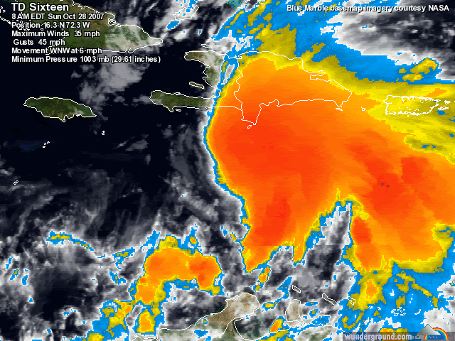
This is quite impressive this morning. Beautiful spin and a very impressive CDO. I'm worried about Hispanola though, especially Haiti, for obvious reasons.
0 likes


Re: Tropical Depression SIXTEEN Recon Obs
716
URNT15 KNHC 281654
AF303 0116A CYCLONE HDOB 06 20071028
162630 1810N 06841W 4656 06400 0305 -085 +999 139022 024 145 000 01
162700 1810N 06843W 4653 06402 0304 -085 +999 111023 026 106 000 05
162730 1810N 06846W 4652 06403 0303 -088 +999 104030 031 999 999 05
162800 1810N 06849W 4658 06394 0303 -086 +999 111030 031 076 000 01
162830 1809N 06852W 4652 06403 0302 -085 +999 124032 034 041 010 01
162900 1809N 06854W 4656 06396 0303 -084 +999 130031 031 041 008 01
162930 1809N 06857W 4654 06397 0301 -084 +999 133031 033 040 007 01
163000 1809N 06900W 4654 06398 0302 -085 +999 132030 032 040 006 01
163030 1809N 06902W 4654 06397 0301 -085 +999 122032 034 039 005 01
163100 1808N 06905W 4654 06397 0301 -085 +999 120033 034 037 004 01
163130 1808N 06907W 4655 06397 0301 -085 +999 121033 035 036 005 01
163200 1808N 06910W 4660 06390 0301 -084 +999 126030 032 037 007 01
163230 1808N 06913W 4654 06398 0300 -085 +999 129027 028 036 005 01
163300 1808N 06915W 4654 06397 0299 -085 +999 138026 027 036 003 01
163330 1807N 06918W 4654 06397 0301 -085 +999 141023 025 036 000 01
163400 1807N 06920W 4654 06400 0302 -085 +999 143024 025 036 000 01
163430 1807N 06923W 4656 06397 0302 -085 +999 143022 024 036 000 01
163500 1807N 06926W 4654 06398 0302 -085 +999 141020 021 035 000 01
163530 1807N 06928W 4655 06398 0302 -085 -085 140019 020 036 000 01
163600 1806N 06931W 4656 06397 0302 -085 -085 139016 017 036 000 01
$$
;
0 likes
Who is online
Users browsing this forum: No registered users and 24 guests