The October 15-20, 2007 Warm Spell: Quick Thoughts

U.S. & Caribbean Weather Discussions and Severe Weather Events

Moderator: S2k Moderators

Forum rules

The posts in this forum are NOT official forecast and should not be used as such. They are just the opinion of the poster and may or may not be backed by sound meteorological data. They are NOT endorsed by any professional institution or STORM2K.

Help Support Storm2K
Message
Author
donsutherland1
S2K Analyst
S2K Analyst
Posts: 2718
Joined: Mon Sep 15, 2003 8:49 pm
Location: New York

The October 15-20, 2007 Warm Spell: Quick Thoughts

#1 Postby donsutherland1 » Tue Oct 09, 2007 10:19 am

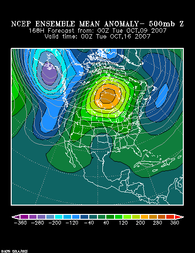
During the October 15-20 timeframe, exceptional warmth is likely to roll across parts of Alberta, Saskatchewan, Manitoba, and the Northern Plains. The latest mean 500 mb height anomalies are forecast to be 240 meters or more above normal by 168 hours:

Image

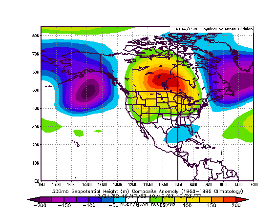
That synoptic setup is reasonably similar to those that occurred in the October 15-31 timeframe during 1952, 1953, 1963, and 1977. The composite 500 mb anomalies for those periods follows:
Image

The following were the highest temperatures for select cities during the four outbreaks of exceptional warmth noted in the composite height anomalies:

October 20-23, 1952:
Bismarck: 79°
Calgary: 73° (22.8°C)
Regina: 68° (20.0°C)
Winnipeg: 73° (22.8°C)

October 16-21, 1953:
Bismarck: 84°
Calgary: 69° (20.6°C)
Regina: 75° (23.9°C)
Winnipeg: 78° (25.6°C)

October 15-18, 1963:
Bismarck: 78°
Calgary: 78° (25.6°C)
Regina: 79° (26.1°C)
Winnipeg: 79° (26.1°C)

October 23-25, 1977:
Bismarck: 78°
Calgary: 70° (21.0°C)
Regina: 70° (20.9°C)
Winnipeg: 74° (23.3°C)

Conclusion:
Given that the size of the above normal 500 mb height anomalies is progged to be somewhat less expansive than those in the composite, the warmth to the south of where those anomalies are centered could be somewhat less extreme than occurred in some of the historic examples.

Nonetheless, given the combination of model and ensemble data coupled with the historic examples cited above, I believe Bismarck will likely see its temperature peak at 73° or above during the referenced timeframe. Calgary, Regina, and Winnipeg should all experience a high temperature of 70° (20.9°C) or above. At Regina and Winnipeg, the temperature could reach or exceed 75° (23.9°C).
0 likes   

dtrain44
Tropical Storm
Tropical Storm
Posts: 141
Joined: Mon Aug 20, 2007 7:45 am
Location: Norman, OK

#2 Postby dtrain44 » Tue Oct 09, 2007 2:12 pm

Don, that's some interesting analysis. How long do you expect that sort of heat to persist?
0 likes   

HurricaneBill
Category 5
Category 5
Posts: 3420
Joined: Sun Apr 11, 2004 5:51 pm
Location: East Longmeadow, MA, USA

Re: The October 15-20, 2007 Warm Spell: Quick Thoughts

#3 Postby HurricaneBill » Tue Oct 09, 2007 4:18 pm

Don, could these warm spells have an influence on severe weather during November?

BTW, Don, I thought you were excellent in "M*A*S*H" and "Ordinary People".
0 likes   

JonathanBelles
Professional-Met
Professional-Met
Posts: 11430
Age: 35
Joined: Sat Dec 24, 2005 9:00 pm
Location: School: Florida State University (Tallahassee, FL) Home: St. Petersburg, Florida
Contact:

#4 Postby JonathanBelles » Tue Oct 09, 2007 6:12 pm

Is that blue blue blotch over Fl a negative anomaly or cooler weather?
0 likes   

donsutherland1
S2K Analyst
S2K Analyst
Posts: 2718
Joined: Mon Sep 15, 2003 8:49 pm
Location: New York

Re:

#5 Postby donsutherland1 » Tue Oct 09, 2007 10:06 pm

Fact789,

Those were slightly negative 500 mb anomalies. However, the historic pattern saw somewhat below normal readings over parts of the Florida peninsula. Interestingly enough, the ensembles are also suggesting somewhat below normal to near normal readings for the most part during the 10/15-20 timeframe.
0 likes   

donsutherland1
S2K Analyst
S2K Analyst
Posts: 2718
Joined: Mon Sep 15, 2003 8:49 pm
Location: New York

Re: The October 15-20, 2007 Warm Spell: Quick Thoughts

#6 Postby donsutherland1 » Tue Oct 09, 2007 10:11 pm

HurricaneBill,

If one kept seeing episodes of exceptional warmth breaking out, there would be the possibility of perhaps an outbreak of severe weather given the contrasting air masses. However, at this time, my very early thinking is that one might see the Mid-Atlantic/Southeast come out close to normal in November with the Northeast westward across the Great Lakes region and Northern Plains come out warmer than normal, though I'm not committing to such an idea yet. If that works out, the contrast between air masses, in general, might be less than normal.
0 likes   

RL3AO
Moderator-Pro Met
Moderator-Pro Met
Posts: 16308
Joined: Thu Jun 14, 2007 10:03 pm
Location: NC

#7 Postby RL3AO » Wed Oct 10, 2007 4:01 pm

CPC agrees. Image
0 likes   

CrazyC83
Professional-Met
Professional-Met
Posts: 34002
Joined: Tue Mar 07, 2006 11:57 pm
Location: Deep South, for the first time!

Re: The October 15-20, 2007 Warm Spell: Quick Thoughts

#8 Postby CrazyC83 » Fri Oct 12, 2007 10:41 pm

donsutherland1 wrote:HurricaneBill,

If one kept seeing episodes of exceptional warmth breaking out, there would be the possibility of perhaps an outbreak of severe weather given the contrasting air masses. However, at this time, my very early thinking is that one might see the Mid-Atlantic/Southeast come out close to normal in November with the Northeast westward across the Great Lakes region and Northern Plains come out warmer than normal, though I'm not committing to such an idea yet. If that works out, the contrast between air masses, in general, might be less than normal.


If this holds up, expect a major severe weather outbreak around October 21-23.
0 likes   

User avatar
Extremeweatherguy
Category 5
Category 5
Posts: 11095
Joined: Mon Oct 10, 2005 8:13 pm
Location: Florida

#9 Postby Extremeweatherguy » Fri Oct 12, 2007 10:49 pm

It looks like Alaska will be getting pretty chilly during this period!
0 likes   

RL3AO
Moderator-Pro Met
Moderator-Pro Met
Posts: 16308
Joined: Thu Jun 14, 2007 10:03 pm
Location: NC

#10 Postby RL3AO » Mon Oct 15, 2007 9:27 pm

Instead of starting a new thread I just wanted to mention that it looks like an extended cool spell in the eastern 2/3rds of the U.S. Maybe Don can do more of his great analysis.
0 likes   

JonathanBelles
Professional-Met
Professional-Met
Posts: 11430
Age: 35
Joined: Sat Dec 24, 2005 9:00 pm
Location: School: Florida State University (Tallahassee, FL) Home: St. Petersburg, Florida
Contact:

#11 Postby JonathanBelles » Mon Oct 15, 2007 9:31 pm

I had the hint to a cool down in my October forecast, however I was two weeks off :lol: . It just seemed not quite right to have a warm winter. I'd love to see an analysis from a promet.
0 likes   

JonathanBelles
Professional-Met
Professional-Met
Posts: 11430
Age: 35
Joined: Sat Dec 24, 2005 9:00 pm
Location: School: Florida State University (Tallahassee, FL) Home: St. Petersburg, Florida
Contact:

#12 Postby JonathanBelles » Mon Oct 15, 2007 9:39 pm

I know this is accuweather and I know this is 7+ days out but WOW!!! Hi:71 and Low 59 on wed oct 24th!! I almost have to say that can no way in hell be right...have a look : http://www.accuweather.com/forecast-15d ... 1&metric=0
0 likes   


Return to “USA & Caribbean Weather”

Who is online

Users browsing this forum: No registered users and 22 guests