INVEST 90L: Gulf of Mexico : Gone from NRL
Moderator: S2k Moderators
-
Ed Mahmoud
Re: INVEST 90L: Gulf of Mexico : Discussions & Images
Leaving soon- I correctly predicted yesterday recon would be canx today, and unless this completely poofs tonight, although the purists will argue that this isn't a tropical system, because it is in the Gulf and will be within 2 days of Lousiana, I predict at least one flight tomorrow.
0 likes
-
frederic79

- Category 1

- Posts: 271
- Joined: Sun Jul 18, 2004 8:48 pm
- Location: Grand Bay, AL
Re: INVEST 90L Models Thread
Is this thing really moving 10 mph? Looks almost stationary to me.
0 likes
-
Stratosphere747
- Category 5

- Posts: 3772
- Joined: Thu Sep 11, 2003 8:34 pm
- Location: Surfside Beach/Freeport Tx
- Contact:
Re: Re:
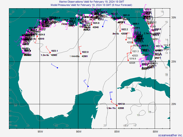
Extremeweatherguy wrote:There is a defined LLC, it is just not very organized ATM.Stratosphere747 wrote:Wouldn't surprise me with a shift in the models back towards the NGOM. Helps to have a defined LLC.
You can see it clearly using the surface obs: http://www.oceanweather.com/data/Gulf-o ... ineM00.gif
Now there is always the possibility that it reforms further north, and we will have to watch for that closely, but currently it is 125 miles WSW of Fort Myers and moving W/WNW (according to the latest TWO).
Oh I see some circulation, but I tend to equate a organized and defined LLC together. As you admit this lacks the organization presently.
May run out of time to do much.
0 likes
-
HouTXmetro

- Category 5
- Posts: 3949
- Joined: Sun Jun 13, 2004 6:00 pm
- Location: District of Columbia, USA
-
Extremeweatherguy

- Category 5
- Posts: 11095
- Joined: Mon Oct 10, 2005 8:13 pm
- Location: Florida

-
americanrebel
-
Extremeweatherguy
- Category 5
- Posts: 11095
- Joined: Mon Oct 10, 2005 8:13 pm
- Location: Florida
-
cycloneye

- Admin

- Posts: 149843
- Age: 69
- Joined: Thu Oct 10, 2002 10:54 am
- Location: San Juan, Puerto Rico
Re: INVEST 90L: Gulf of Mexico : Discussions & Images
90L is a tease for the big one.See Bahamas thread in Talking Tropics forum and see for yourselves what I am talking about.
0 likes
-
wxman57

- Moderator-Pro Met

- Posts: 23178
- Age: 68
- Joined: Sat Jun 21, 2003 8:06 pm
- Location: Houston, TX (southwest)
Re: INVEST 90L: Gulf of Mexico : Discussions & Images
cycloneye wrote:90L is a tease for the big one.See Bahamas thread in Talking Tropics forum and see for yourselves what I am talking about.
I agree with you there, cycloneye. I'm much more concerned about next week than this system. However, I think there's a good chance this low will become at least an STD in the next 24-36 hours and quite possibly a weak STS/TS at landfall Friday morning. Not a big wind threat inland, though.
0 likes
-
SETXweatherwatcher
- Tropical Low

- Posts: 46
- Joined: Mon Aug 28, 2006 12:43 pm
- Location: Port Neches, TX
Re: INVEST 90L: Gulf of Mexico : Discussions & Images
How far inland should not worry too much about wind? As the crow flies, I am only about 18-22 miles inland.
0 likes
-
cycloneye
- Admin
- Posts: 149843
- Age: 69
- Joined: Thu Oct 10, 2002 10:54 am
- Location: San Juan, Puerto Rico
Re: INVEST 90L Models Thread
770
WHXX04 KWBC 022331
CHGQLM
ATTENTION...NATIONAL HURRICANE CENTER
NCEP COUPLED GFDL HURRICANE MODEL FORECAST MADE FOR
TROPICAL DEPRESSION INVEST 90L
INITIAL TIME 18Z OCT 2
DISCLAIMER ... THIS INFORMATION IS PROVIDED AS GUIDANCE. IT
REQUIRES INTERPRETATION BY HURRICANE SPECIALISTS AND SHOULD
NOT BE CONSIDERED AS A FINAL PRODUCT. PLEASE SEE THE TPC/NHC
OFFICIAL FORECAST.
FORECAST STORM POSITION
HOUR LATITUDE LONGITUDE HEADING/SPEED(KT)
0 24.3 83.9 260./11.1
6 25.1 84.8 310./11.7
12 26.1 85.9 311./14.3
18 26.4 87.4 281./13.8
24 26.2 88.2 256./ 6.6
30 26.4 88.7 281./ 5.3
36 26.8 89.4 303./ 8.0
42 27.2 90.5 288./10.3
48 27.6 91.3 300./ 7.8
54 27.9 91.8 298./ 5.4
60 28.3 92.8 294./ 9.9
66 28.7 93.7 293./ 9.0
72 29.8 94.4 325./12.4
78 30.9 95.6 314./14.5
84 32.4 96.4 332./16.8
90 34.2 96.9 344./18.3
96 36.2 96.5 10./20.7
102 38.7 95.7 18./25.4
108 41.3 94.2 30./29.0
114 43.9 91.7 45./31.3
120 45.3 88.2 67./28.3
126 45.7 84.6 84./25.9
18z GFDL landfall in Galveston.
0 likes
-
SETXweatherwatcher
- Tropical Low
- Posts: 46
- Joined: Mon Aug 28, 2006 12:43 pm
- Location: Port Neches, TX
Re: INVEST 90L Models Thread
Adjust that a little farther to the east, as usual and you have BMT/PA area. Not being a smarty pants, just everytime they say Galveston, it hits here. If they were to say BMT/PA then it would be a SW LA storm.
0 likes
-
Ed Mahmoud
Re: INVEST 90L: Gulf of Mexico : Discussions & Images
SETXweatherwatcher wrote:How far inland should not worry too much about wind? As the crow flies, I am only about 18-22 miles inland.
A 60 mph tropical storm is about the same as a low end severe thunderstorm, wind wise. Widely scattered power outages, some tree limbs.
I'd think BPT area would have lost all the easily downed tree limbs during Humberto, so, in my very unofficial opinion, probably not terribly bad.
0 likes
-
wxman57
- Moderator-Pro Met
- Posts: 23178
- Age: 68
- Joined: Sat Jun 21, 2003 8:06 pm
- Location: Houston, TX (southwest)
Re: INVEST 90L: Gulf of Mexico : Discussions & Images
SETXweatherwatcher wrote:How far inland should not worry too much about wind? As the crow flies, I am only about 18-22 miles inland.
For a subtropical storm like it may well be, winds inland just a few miles would be about half that out over the water. So if it has 50 mph winds offshore, only 20-25 mph inland. If it gets a full, warm core then your winds could be a bit higher but TS force winds would be confined to the first couple of miles inland.
0 likes

Re: INVEST 90L: Gulf of Mexico : Discussions & Images
Ed Mahmoud wrote:SETXweatherwatcher wrote:How far inland should not worry too much about wind? As the crow flies, I am only about 18-22 miles inland.
A 60 mph tropical storm is about the same as a low end severe thunderstorm, wind wise. Widely scattered power outages, some tree limbs.
I'd think BPT area would have lost all the easily downed tree limbs during Humberto, so, in my very unofficial opinion, probably not terribly bad.
I was in the Golden Triangle today. Sabine is a mess and trees still show scarring. Humberto just made things worse.....
0 likes
-
cycloneye
- Admin
- Posts: 149843
- Age: 69
- Joined: Thu Oct 10, 2002 10:54 am
- Location: San Juan, Puerto Rico
Re: INVEST 90L Models Thread
0 likes


>>A 60 mph tropical storm is about the same as a low end severe thunderstorm, wind wise. Widely scattered power outages, some tree limbs.
Inland, yeah. But the closer you are to the center, especially if it was to become tropical, the more bands you would see and certainly the amplified period of time you would experience them as compared to a thunderstorm.
-----------------------------------
>>I agree with you there, cycloneye. I'm much more concerned about next week than this system. However, I think there's a good chance this low will become at least an STD in the next 24-36 hours and quite possibly a weak STS/TS at landfall Friday morning. Not a big wind threat inland, though.
Interesting thoughts on both threats 57. Thanks.
Steve
0 likes
-
SETXweatherwatcher
- Tropical Low
- Posts: 46
- Joined: Mon Aug 28, 2006 12:43 pm
- Location: Port Neches, TX
Re:
Steve wrote:>>A 60 mph tropical storm is about the same as a low end severe thunderstorm, wind wise. Widely scattered power outages, some tree limbs.
Inland, yeah. But the closer you are to the center, especially if it was to become tropical, the more bands you would see and certainly the amplified period of time you would experience them as compared to a thunderstorm.
-----------------------------------
>>I agree with you there, cycloneye. I'm much more concerned about next week than this system. However, I think there's a good chance this low will become at least an STD in the next 24-36 hours and quite possibly a weak STS/TS at landfall Friday morning. Not a big wind threat inland, though.
Interesting thoughts on both threats 57. Thanks.
Steve
Humberto wasn't that bad, the eye actually passed right over us, here in Port Neches. But at work, bad! Power lines and poles snapped in half. And only 10 miles away.
0 likes
Who is online
Users browsing this forum: No registered users and 43 guests