Y'all we don't need to keep the AFD in the quote with every reply - thanks!
Edit: I fixed it
INVEST 90L: Gulf of Mexico : Gone from NRL
Moderator: S2k Moderators
-
jasons2k

- Storm2k Executive

- Posts: 8290
- Age: 52
- Joined: Wed Jul 06, 2005 12:32 pm
- Location: The Woodlands, TX
Re: INVEST 90L:Gulf of Mexico : Discussions=5:30 PM TWO Shortly
And here is the disco snippet from HGX:
Here is their forecast graphic:

http://www.srh.noaa.gov/hgx/graph_haz/g ... stHGX2.php
AREA FORECAST DISCUSSION
NATIONAL WEATHER SERVICE HOUSTON/GALVESTON TX
343 PM CDT TUE OCT 2 2007
THE AREA OF LOW PRESSURE IN THE EASTERN GULF CONTINUES TO DEEPEN
PRESSURES AS OF 19Z WERE DOWN TO 1005 MB THAT IS DOWN 7 MB FROM
YESTERDAY AT THIS TIME. WINDS AT BUOY 42003 AND 42036 HAVE BEEN
SHOWING SUSTAINED WINDS OF 15-25 KNOTS WITH GUSTS OF 24-37 KNOTS
MOST OF THE DAY. 42003 HAS HAD PERSISTENT THUNDERSTORMS NEAR IT ON
THE WEST SIDE OF THE CIRCULATION ALL AFTERNO0N. THE WRF/GFS/ECMWF
ALL TAKE IT WEST WEDNESDAY AND EARLY THURSDAY THEN TURN IT NW
(EXCEPTION BEING THE ECMWF WHICH IS STILL WNW) BRINGING A LARGE
CIRCULATION INTO THE NORTHWEST GULF THURSDAY NIGHT AND FRIDAY. A
COUPLE OF THINGS WILL BE WORKING AGAINST RAPID
INTENSIFICATION...WIND SHEAR AND THE COLD CORE TO START WITH AND
THE FACT THAT A GOOD DEAL OF MID AND UPPER LEVEL DRY AIR HAS
WRAPPED AROUND THE SYSTEM PER WATER VAPOR. AS THE SYSTEM MOVES
WEST THE SHEAR SHOULD RELAX AS THE CORE WARMS ESPECIALLY ON
THURSDAY THE UPPER WINDS RELAX...AND THE DEEPEST MOISTURE WILL
LIKELY STILL BE TO THE EAST OR WELL TO THE EAST OF THE SYSTEM. THE
TIGHTEST GRADIENT SHOULD BE ON THE EAST SIDE AND NORTHEAST SIDE OF
THE STORMS SO AM NOT EXPECTING ANY PARTICULARLY STRONG WINDS HERE.
GIVEN THE CURRENT SUITE OF MODELS AM FAVORING A TRACK TOWARDS
SABINE MOUTH FRIDAY. IF IT TRANSITIONS TO A TROPICAL SYSTEM RATHER
THAN A SUB-TROPICAL THURSDAY SEEMS LIKE THE DAY FOR IT. WITH THIS
IN MIND HAVE GONE WITH HIGHER POPS SOUTHEAST THURSDAY-FRIDAY AND
INCREASING CLOUDS. WILL HOLD OFF ON ANY MENTION OF LOCALLY HEAVY
RAINFALL AS IT IS STILL FAR FROM ANY CERTAINTY ON THE TRACK.
STAY TUNED.
Here is their forecast graphic:
http://www.srh.noaa.gov/hgx/graph_haz/g ... stHGX2.php
0 likes

-
Ed Mahmoud
Re: INVEST 90L:Gulf of Mexico : Discussions=5:30 PM TWO Shortly
TROPICAL WEATHER OUTLOOK
NWS TPC/NATIONAL HURRICANE CENTER MIAMI FL
530 PM EDT TUE OCT 2 2007
FOR THE NORTH ATLANTIC...CARIBBEAN SEA AND THE GULF OF MEXICO...
SHOWERS AND THUNDERSTORMS OVER THE EASTERN GULF OF MEXICO ARE
PRIMARILY ASSOCIATED WITH AN UPPER-LEVEL LOW AND A BROAD AREA OF
SURFACE LOW PRESSURE CENTERED ABOUT 125 MILES WEST-SOUTHWEST OF
FORT MYERS FLORIDA. THIS SYSTEM SHOWS SOME SIGNS OF
ORGANIZATION...AND HAS THE POTENTIAL TO EVOLVE INTO A SUBTROPICAL
OR TROPICAL CYCLONE DURING THE NEXT DAY OR SO AS IT MOVES TO THE
WEST OR WEST-NORTHWEST AT ABOUT 10 MPH. INTEREST ALONG THE
NORTHERN GULF COAST SHOULD MONITOR THE PROGRESS OF THIS SYSTEM.
ELSEWHERE...TROPICAL CYCLONE FORMATION IS NOT EXPECTED DURING THE
NEXT 48 HOURS.
$$
FORECASTER RHOME/PASCH
0 likes


Re: INVEST 90L:Gulf of Mexico : 5:30 PM TWO at page 14
This WV loop shows some kind of circulation racing almost due North towards Apalachicola:
http://www.ssd.noaa.gov/goes/flt/t1/loop-wv.html
Is this the ULL?
http://www.ssd.noaa.gov/goes/flt/t1/loop-wv.html
Is this the ULL?
0 likes
-
Extremeweatherguy

- Category 5

- Posts: 11095
- Joined: Mon Oct 10, 2005 8:13 pm
- Location: Florida
Re: Re:
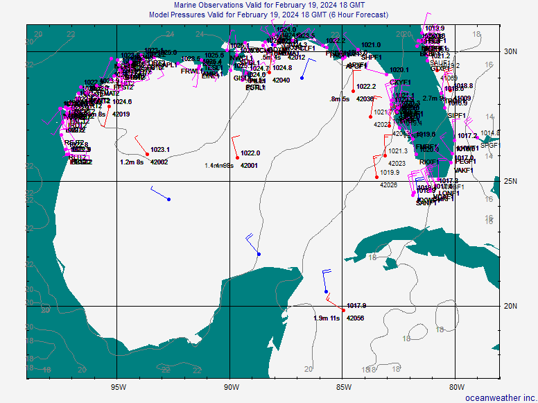
I believe you are correct. Surface data suggests that the spin west of Tampa is not at the surface. The true LLC looks to be to the SW of that area... http://www.oceanweather.com/data/Gulf-o ... ineM00.gifamericanrebel wrote:eaglegirl wrote:Can anyone tell me what the comma shaped area SW of Tampa is?
[img][/img]
This sure looks like the ULL, and the LLC should be to the West of this. I think that is what it is. Maybe the Pro Mets can clarify this a little more?
0 likes
-
americanrebel

-
eaglegirl

- S2K Supporter

- Posts: 60
- Joined: Sun Sep 09, 2007 10:14 am
- Location: Tallahassee, FL
- Contact:
First, I apologize for the trouble I am having as I learn to upload images. I will try again with a closer view of what I am asking about. It is the "clear" comma shaped area SW of Tampa. It kind of looks like an eye trying to form... but, I know that just can't be.
Thanks again for any input.

Thanks again for any input.

Last edited by eaglegirl on Tue Oct 02, 2007 4:29 pm, edited 1 time in total.
0 likes
-
cycloneye

- Admin
- Posts: 149843
- Age: 69
- Joined: Thu Oct 10, 2002 10:54 am
- Location: San Juan, Puerto Rico
Re: INVEST 90L Models Thread

Since this thread is to post all the models,here is what the 18z NAM shows as landfall for 90L,Central Texas coast.
Off-Topic: It shows something in the NW Caribbean as well in the Bahamas,but that can be discussed in Talking Tropics forum.
0 likes
-
americanrebel
-
Stratosphere747
- Category 5
- Posts: 3772
- Joined: Thu Sep 11, 2003 8:34 pm
- Location: Surfside Beach/Freeport Tx
- Contact:

-
cycloneye
- Admin
- Posts: 149843
- Age: 69
- Joined: Thu Oct 10, 2002 10:54 am
- Location: San Juan, Puerto Rico
Re: INVEST 90L:Gulf of Mexico : 5:30 PM TWO at page 14
RL3AO where is your scale table for the 5:30 PM TWO?  How do you rank it?
0 likes
-
Extremeweatherguy
- Category 5
- Posts: 11095
- Joined: Mon Oct 10, 2005 8:13 pm
- Location: Florida
Re:
There is a defined LLC, it is just not very organized ATM.Stratosphere747 wrote:Wouldn't surprise me with a shift in the models back towards the NGOM. Helps to have a defined LLC.
You can see it clearly using the surface obs: http://www.oceanweather.com/data/Gulf-o ... ineM00.gif
Now there is always the possibility that it reforms further north, and we will have to watch for that closely, but currently it is 125 miles WSW of Fort Myers and moving W/WNW (according to the latest TWO).
Last edited by Extremeweatherguy on Tue Oct 02, 2007 4:40 pm, edited 1 time in total.
0 likes
-
Extremeweatherguy
- Category 5
- Posts: 11095
- Joined: Mon Oct 10, 2005 8:13 pm
- Location: Florida
Re:
If the surface reports and TWO are accurate, then it should be in the general vicinity of where the 85W line meets the 25N line. It is still fairly broad though, so it is hard to pick out the exact center.americanrebel wrote:What just south of 42003???
0 likes
Who is online
Users browsing this forum: No registered users and 49 guests