Ex Tropical Depression KAREN: Discussions & Images
Moderator: S2k Moderators
Re: Tropical Storm KAREN: Central ATL: Discussion & Images
Meaningless if it shoots north into the weakness like they expect. Ocean storm.
0 likes
-
Matt-hurricanewatcher
Re: Tropical Storm KAREN: Central ATL: Discussion & Images
The more west it go's the better its chances to....
0 likes
-
cycloneye

- Admin

- Posts: 148553
- Age: 69
- Joined: Thu Oct 10, 2002 10:54 am
- Location: San Juan, Puerto Rico
Re: Tropical Storm KAREN: Central ATL: Discussion & Images
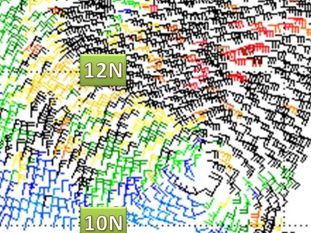
Hey peeps,you may want to see this quickscat.

Is a recent one.
Is a recent one.
0 likes
-
Gustywind

- Category 5

- Posts: 12334
- Joined: Mon Sep 03, 2007 7:29 am
- Location: Baie-Mahault, GUADELOUPE
Re: Re:
cycloneye wrote:cycloneye wrote:
25/2345 UTC 10.4N 40.3W T2.5/2.5 KAREN -- Atlantic Ocean
Did Karen moved a little south of the 5 PM position of 11:1n? Or this SSD position is not correct?
Probably a center relocation.cycloneye wrote: 25/2345 UTC 10.4N 40.3W T2.5/2.5 KAREN -- Atlantic Ocean
Did Karen moved a little south of the 5 PM position of 11:1n? Or this SSD position is not correct?
Probably a center relocation.
punkyg wrote:Gustywind wrote:Genearous wobble or relocation....
What do you mean?
is it moving alittle south of the forcast point?
Yeah punkyg latest SSD t numbers are very south 10.4N 40.3W!
cycloneye wrote:25/2345 UTC 10.4N 40.3W T2.5/2.5 KAREN -- Atlantic Ocean
Did Karen moved a little south of the 5 PM position of 11:1n? Or this SSD position is not correct?
25/2345 UTC 10.4N 40.3W T2.5/2.5 KAREN -- Atlantic Ocean
Did Karen moved a little south of the 5 PM position of 11:1n? Or this SSD position is not correct?
0 likes
-
Matt-hurricanewatcher


-
cycloneye
- Admin
- Posts: 148553
- Age: 69
- Joined: Thu Oct 10, 2002 10:54 am
- Location: San Juan, Puerto Rico
Re: Tropical Storm KAREN: ATL: Latest Quickscat at page 23
The position of the center according to this recent pass,says that Karen is pretty much on a westward motion.It may be a temporary track,but as more west it goes,more west the NHC track will be,and you know what is more west around 60w.
0 likes
-
Gustywind
- Category 5
- Posts: 12334
- Joined: Mon Sep 03, 2007 7:29 am
- Location: Baie-Mahault, GUADELOUPE
Re: Tropical Storm KAREN: Central ATL: Discussion & Images
Matt-hurricanewatcher wrote:Quickscat about 10.8 north...
ok tkanks
0 likes
Re: Tropical Storm KAREN: ATL: Latest Quickscat at page 23
I doubt they could be SO wrong as to plot an almost north track and have it go west. We will see where it is by 50W and then start worrying.
0 likes

Re: Tropical Storm KAREN: ATL: Latest Quickscat at page 23
Looks to be somewhere between 10.5 and 10.8 right now. I'd put it at about 40.4 west. looks to have moved due west in the past few hours. Even if its not a threat to the US, every degree westward makes it more of a threat to the Northeastern Lesser Antilles and Bermuda, so something to remain vigilant about.
0 likes

-
Emmett_Brown

- Category 5
- Posts: 1433
- Joined: Wed Aug 24, 2005 9:10 pm
- Location: Sarasota FL
Re: Tropical Storm KAREN: Central ATL: Discussion & Images
Gustywind wrote:Matt-hurricanewatcher wrote:Quickscat about 10.8 north...
ok tkanksso souther than the 5pm forecast at 11,1N....
Looking at the quickscat, I think it is more like 10.5 or 10.6, but that might be splitting hairs. Does anyone know the margin of error for quickscat... how accurate would this center position be?
0 likes
-
Gustywind
- Category 5
- Posts: 12334
- Joined: Mon Sep 03, 2007 7:29 am
- Location: Baie-Mahault, GUADELOUPE
Re: Tropical Storm KAREN: ATL: Latest Quickscat at page 23
cycloneye wrote:The position of the center according to this recent pass,says that Karen is pretty much on a westward motion.It may be a temporary track,but as more west it goes,more west the NHC track will be,and you know what is more west around 60w.
Absolutely Cycloneye very good point
0 likes
-
Gustywind
- Category 5
- Posts: 12334
- Joined: Mon Sep 03, 2007 7:29 am
- Location: Baie-Mahault, GUADELOUPE
Re: Tropical Storm KAREN: ATL: Latest Quickscat at page 23
BigA wrote:Looks to be somewhere between 10.5 and 10.8 right now. I'd put it at about 40.4 west. looks to have moved due west in the past few hours. Even if its not a threat to the US, every degree westward makes it more of a threat to the Northeastern Lesser Antilles and Bermuda, so something to remain vigilant about.
Absolutely guy this put us in "troubles" virtualy each degree more west, as you said we should remain vigilant
0 likes
-
Gustywind
- Category 5
- Posts: 12334
- Joined: Mon Sep 03, 2007 7:29 am
- Location: Baie-Mahault, GUADELOUPE
Re: Tropical Storm KAREN: ATL: Latest Quickscat at page 23
Sanibel wrote:I doubt they could be SO wrong as to plot an almost north track and have it go west. We will see where it is by 50W and then start worrying.
I hope that since June 1, but thus this season i've never saw something higher than Ingrid... beginning near 20w-60w folks so for the moment it seems a kind utopia mysteriosly...but hope for a fish for this time ....this will change but assuming the entery trend of the season i've real dots

0 likes
-
Matt-hurricanewatcher
Re: Tropical Storm KAREN: ATL: Latest Quickscat at page 23
The central core of this system is becoming much better organized over the last few hours...Also see how the convection is pushing slowly outwards to the northwest quad, but be a sign that the ULL to the north of it could help strengthen it over the next 6-24 hours. Also it appears to be moving west or just osuth of west.
0 likes
-
Gustywind
- Category 5
- Posts: 12334
- Joined: Mon Sep 03, 2007 7:29 am
- Location: Baie-Mahault, GUADELOUPE
Re: Tropical Storm KAREN: ATL: Latest Quickscat at page 23
OURAGAN wrote:10,9N/40,4W on NRL SITE
Hi ouragan happy to see you! Tkanks for the info!
0 likes
Re: Tropical Storm KAREN: CEN ATL: Discussions & Images
Karen is already south of the nhc track, and I don't see it to go northwest soon.
0 likes
Who is online
Users browsing this forum: No registered users and 60 guests