Ex Tropical Depression KAREN: Discussions & Images

Moderator: S2k Moderators

Message
Author
User avatar
Cyclenall
Category 5
Category 5
Posts: 6666
Joined: Thu Jun 08, 2006 10:01 pm
Location: Ontario, Canada

Re: INVEST 96L: East Atlantic : Discussions & Images

#341 Postby Cyclenall » Mon Sep 24, 2007 8:48 pm

Matt-hurricanewatcher wrote:Yes, it was isabel. Dog 1950 was also one. But they are very rare. In out near 40-50 west the TCHP could not support one.

That's why if you want a category 5 hurricane, you don't want a fish because the chances are so low. Isabel was not a fish either too but could have been given it's location.

It seems my %'s are catching on! :)
0 likes   

CrazyC83
Professional-Met
Professional-Met
Posts: 34002
Joined: Tue Mar 07, 2006 11:57 pm
Location: Deep South, for the first time!

Re: INVEST 96L: East Atlantic : Discussions & Images

#342 Postby CrazyC83 » Mon Sep 24, 2007 8:49 pm

Cyclenall wrote:
Matt-hurricanewatcher wrote:Yes, it was isabel. Dog 1950 was also one. But they are very rare. In out near 40-50 west the TCHP could not support one.

That's why if you want a category 5 hurricane, you don't want a fish because the chances are so low. Isabel was not a fish either too but could have been given it's location.

It seems my %'s are catching on! :)


Cat 5 fishes are very rare; there are only three known (Dog, Easy and Cleo). Had there been a ridge over the Mid-Atlantic (instead of over Atlantic Canada), it would have forced Isabel northeast and that would have been a Cat 5 fish...
0 likes   

Sanibel
Category 5
Category 5
Posts: 10375
Joined: Mon Aug 30, 2004 11:06 pm
Location: Offshore SW Florida

Re: INVEST 96L: East Atlantic : Discussions & Images

#343 Postby Sanibel » Mon Sep 24, 2007 8:51 pm

Geesh guys, let this become a TS first.
0 likes   

User avatar
TheEuropean
Professional-Met
Professional-Met
Posts: 1796
Age: 59
Joined: Tue Sep 20, 2005 3:17 pm
Location: Voerde, Germany
Contact:

Re: Re:

#344 Postby TheEuropean » Mon Sep 24, 2007 8:54 pm

CrazyC83 wrote:(I also think Carrie 1957 was a Cat 5 in the open Atlantic)


I don't think that Carrie was a Cat 5, but it was very near Cat 5 with max winds up to 155mph.

The german sailship "Pamir" sunk in the hurricane on Sep. 21st. A few days ago many people here in germany remember the 80 deaths on the ship 50 years ago.
0 likes   

njweather
Tropical Storm
Tropical Storm
Posts: 169
Joined: Fri Aug 17, 2007 10:45 pm
Location: Washington, DC

Re:

#345 Postby njweather » Mon Sep 24, 2007 9:07 pm

GeneratorPower wrote:Invest 96L, a.k.a, Tropical Low "Tip".


:ggreen: :ggreen:

Image
0 likes   

Matt-hurricanewatcher

Re: INVEST 96L: East Atlantic : Discussions & Images

#346 Postby Matt-hurricanewatcher » Mon Sep 24, 2007 9:11 pm

A typhoon tips like hurricane could never form in the Atlantic. To much shear and not enough warm water....In fact this system if it does not become more compact could become a top end system for the Atlantic for size.
0 likes   

RL3AO
Moderator-Pro Met
Moderator-Pro Met
Posts: 16308
Joined: Thu Jun 14, 2007 10:03 pm
Location: NC

#347 Postby RL3AO » Mon Sep 24, 2007 9:12 pm

Tip wouldn't fit very well in the Caribbean or the GOM and thats the only place it could approach 870mb.
0 likes   

User avatar
N2FSU
S2K Supporter
S2K Supporter
Posts: 1062
Joined: Thu Sep 04, 2003 2:04 pm
Location: Tallahassee, FL

Re: INVEST 96L: East Atlantic : Discussions & Images

#348 Postby N2FSU » Mon Sep 24, 2007 9:17 pm

Here is a great WV loop to show the flow out ahead of this developing system:

http://www.atmos.washington.edu/~ovens/loops/wxloop.cgi?wv_east_enhanced+12
0 likes   

Derek Ortt

#349 Postby Derek Ortt » Mon Sep 24, 2007 9:17 pm

Matt,

I do not understand your statement about a tip not being possible in the Atlantic. The reasons you gave just do not make sense.

A tip sized storm could form if there is a large anti-cyclone or interacting with a trough. Wilma was not exactly small when it was east of the Bahamas
0 likes   

RL3AO
Moderator-Pro Met
Moderator-Pro Met
Posts: 16308
Joined: Thu Jun 14, 2007 10:03 pm
Location: NC

#350 Postby RL3AO » Mon Sep 24, 2007 9:18 pm

a storm with TS winds extending 1300 miles could fit in the Caribbean?
0 likes   

User avatar
fci
S2K Supporter
S2K Supporter
Posts: 3324
Joined: Tue Sep 14, 2004 10:29 am
Location: Lake Worth, FL

Re:

#351 Postby fci » Mon Sep 24, 2007 9:21 pm

Derek Ortt wrote:Matt,

I do not understand your statement about a tip not being possible in the Atlantic. The reasons you gave just do not make sense.

A tip sized storm could form if there is a large anti-cyclone or interacting with a trough. Wilma was not exactly small when it was east of the Bahamas


Derek:
When was Wilma EAST of the Bahamas?
It went between Jupiter and Grand Bahama and never got exactly east of them.
0 likes   

Matt-hurricanewatcher

Re:

#352 Postby Matt-hurricanewatcher » Mon Sep 24, 2007 9:22 pm

Derek Ortt wrote:Matt,

I do not understand your statement about a tip not being possible in the Atlantic. The reasons you gave just do not make sense.

A tip sized storm could form if there is a large anti-cyclone or interacting with a trough. Wilma was not exactly small when it was east of the Bahamas


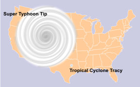
I'm not talking about a system that has a high pressure to its north, as its becoming extratropical like Wilma. I'm talking about a system that is as strong and big as Tips forming over the Atlantic. In which case I think it would be pretty hard, the western caribbean or maybe the gulf has the sst's/tchp to suppor the strength. If it tryed to form over the gulf of Mexico, it would suck in dry air from land. In which would kill its chances of becoming a system like Tips, on the other hand the Caribbean, it might have a better chance. But also the Caribbean is not big enough to allow the system to grow to the size; with the inflow going over Cuba,Hati. East of the islands or north of them would be the place I would watch. But north of 25 north you have shear that is normally in place. Maybe if the big Anticyclone forms, but would it be able to gain the strength and overall size?
Last edited by Matt-hurricanewatcher on Mon Sep 24, 2007 9:25 pm, edited 1 time in total.
0 likes   

User avatar
Cyclenall
Category 5
Category 5
Posts: 6666
Joined: Thu Jun 08, 2006 10:01 pm
Location: Ontario, Canada

#353 Postby Cyclenall » Mon Sep 24, 2007 9:24 pm

We have to remember that Tip was NOT at it's largest when it was at peak strength.
0 likes   

User avatar
Tampa Bay Hurricane
Category 5
Category 5
Posts: 5597
Age: 37
Joined: Fri Jul 22, 2005 7:54 pm
Location: St. Petersburg, FL

#354 Postby Tampa Bay Hurricane » Mon Sep 24, 2007 9:25 pm

Come on baby lets see an upgrade...11 PM is coming up
and so is that nice upgrade. I llove it when the action
goes crazy. I hope 97L becomes a tropical storm and hits
florida...
and I hope 96L becomes a big hurricane that would be so
awesome.
0 likes   

Derek Ortt

#355 Postby Derek Ortt » Mon Sep 24, 2007 9:25 pm

Wilma was east of the Bahamas after it flattened Grand Bahama Island
0 likes   

User avatar
Tampa Bay Hurricane
Category 5
Category 5
Posts: 5597
Age: 37
Joined: Fri Jul 22, 2005 7:54 pm
Location: St. Petersburg, FL

#356 Postby Tampa Bay Hurricane » Mon Sep 24, 2007 9:27 pm

Wilma's tropical storm force winds over me were AWESOME. that
was the last time I had a REAL storm besides alberto and barry.

Of course the damage was horrible, but WILMA was such an
AWESOME storm I loved watching those winds howl.
Holy Crapp What a Magnificent event!!!!
0 likes   

Brent
S2K Supporter
S2K Supporter
Posts: 38089
Age: 36
Joined: Sun May 16, 2004 10:30 pm
Location: Tulsa Oklahoma
Contact:

Tropical Depression KAREN: Advisories

#357 Postby Brent » Mon Sep 24, 2007 9:31 pm

TROPICAL DEPRESSION TWELVE FORECAST/ADVISORY NUMBER 1
NWS TPC/NATIONAL HURRICANE CENTER MIAMI FL AL122007
0300 UTC TUE SEP 25 2007

TROPICAL DEPRESSION CENTER LOCATED NEAR 10.1N 36.2W AT 25/0300Z
POSITION ACCURATE WITHIN 30 NM

PRESENT MOVEMENT TOWARD THE WEST-NORTHWEST OR 285 DEGREES AT 14 KT

ESTIMATED MINIMUM CENTRAL PRESSURE 1006 MB
MAX SUSTAINED WINDS 30 KT WITH GUSTS TO 40 KT.
WINDS AND SEAS VARY GREATLY IN EACH QUADRANT. RADII IN NAUTICAL
MILES ARE THE LARGEST RADII EXPECTED ANYWHERE IN THAT QUADRANT.

REPEAT...CENTER LOCATED NEAR 10.1N 36.2W AT 25/0300Z
AT 25/0000Z CENTER WAS LOCATED NEAR 9.9N 35.7W

FORECAST VALID 25/1200Z 10.6N 38.4W
MAX WIND 35 KT...GUSTS 45 KT.
34 KT... 40NE 30SE 0SW 40NW.

FORECAST VALID 26/0000Z 11.2N 41.4W
MAX WIND 45 KT...GUSTS 55 KT.
34 KT... 50NE 30SE 30SW 50NW.

FORECAST VALID 26/1200Z 11.8N 44.5W
MAX WIND 50 KT...GUSTS 60 KT.
50 KT... 25NE 0SE 0SW 25NW.
34 KT... 75NE 40SE 40SW 75NW.

FORECAST VALID 27/0000Z 12.5N 47.4W
MAX WIND 55 KT...GUSTS 65 KT.
50 KT... 25NE 0SE 0SW 25NW.
34 KT... 75NE 40SE 40SW 75NW.

FORECAST VALID 28/0000Z 15.3N 50.9W
MAX WIND 60 KT...GUSTS 75 KT.
50 KT... 40NE 30SE 30SW 40NW.
34 KT... 90NE 60SE 60SW 90NW.

EXTENDED OUTLOOK. NOTE...ERRORS FOR TRACK HAVE AVERAGED NEAR 225 NM
ON DAY 4 AND 300 NM ON DAY 5...AND FOR INTENSITY NEAR 20 KT EACH DAY

OUTLOOK VALID 29/0000Z 19.0N 53.0W
MAX WIND 60 KT...GUSTS 75 KT.

OUTLOOK VALID 30/0000Z 22.0N 54.5W
MAX WIND 60 KT...GUSTS 75 KT.

REQUEST FOR 3 HOURLY SHIP REPORTS WITHIN 300 MILES OF 10.1N 36.2W

NEXT ADVISORY AT 25/0900Z

$$
FORECASTER BROWN
0 likes   

User avatar
Chacor
Category 5
Category 5
Posts: 10229
Joined: Mon Oct 02, 2006 10:43 pm
Location: Singapore

#358 Postby Chacor » Mon Sep 24, 2007 9:31 pm

TD 12 is here.
0 likes   

weatherguru18

Re: INVEST 96L: East Atlantic : Discussions & Images

#359 Postby weatherguru18 » Mon Sep 24, 2007 9:31 pm

There are a handful of people who claim on the weather forum on khou that it WILL be upgraded at 10pm our time. They are certain of this. Can anybody verify?
0 likes   

Sanibel
Category 5
Category 5
Posts: 10375
Joined: Mon Aug 30, 2004 11:06 pm
Location: Offshore SW Florida

Re: INVEST 96L: East Atlantic : Discussions & Images

#360 Postby Sanibel » Mon Sep 24, 2007 9:32 pm

Ah, this system is doing some weird structure stuff. I'm unsure if it is changing form to strengthen or having organization problems.
0 likes   


Return to “2007”

Who is online

Users browsing this forum: No registered users and 11 guests