INVEST 97L: Near Puerto Rico :Discussions & Images

Moderator: S2k Moderators

Message
Author
User avatar
gatorcane
S2K Supporter
S2K Supporter
Posts: 23691
Age: 47
Joined: Sun Mar 13, 2005 3:54 pm
Location: Boca Raton, FL

Re:

#221 Postby gatorcane » Mon Sep 24, 2007 12:59 pm

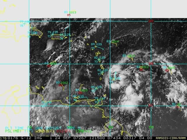
MWatkins wrote:St Lucia and Barbados are both reporting WSW winds at 17 and 21 mph respectively. Pressures are not falling appreciably...so these westerly winds at the surface down there are probably not related to anything going on directly to the east...

MW

DISCLAIMER

This is NOT an official forecast and should not be used as such. This is my own personal opinion and may or may not be backed by sound meteorological data. It is NOT endorsed by any professional institution or storm2k.org. For official information, please refer to the NHC and NWS products.


Mike I don't know, those west winds are pretty consistent. Pressure falls can be delayed and could be underway shortly. Big blowup of deep reds now near the "LLC."

Its starting to make a run....

Movement is a very steady NW at 15mph and so at this rate could miss Hispaniola to the east and skim Puerto Rico.

I don't think this is going to be a Caribbean storm...
Last edited by gatorcane on Mon Sep 24, 2007 1:02 pm, edited 2 times in total.
0 likes   

User avatar
HURAKAN
Professional-Met
Professional-Met
Posts: 46086
Age: 38
Joined: Thu May 20, 2004 4:34 pm
Location: Key West, FL
Contact:

#222 Postby HURAKAN » Mon Sep 24, 2007 1:00 pm

IMAGES:

Image

Image

Image
0 likes   

User avatar
Gustywind
Category 5
Category 5
Posts: 12334
Joined: Mon Sep 03, 2007 7:29 am
Location: Baie-Mahault, GUADELOUPE

#223 Postby Gustywind » Mon Sep 24, 2007 1:10 pm

NRL Site latest:
13,1 N 59,0 W 25kts 1008hpa 1715 UTC
:darrow:
http://www.nrlmry.navy.mil/tc-bin/tc_ho ... rovap/dmsp
0 likes   

User avatar
HURAKAN
Professional-Met
Professional-Met
Posts: 46086
Age: 38
Joined: Thu May 20, 2004 4:34 pm
Location: Key West, FL
Contact:

#224 Postby HURAKAN » Mon Sep 24, 2007 1:15 pm

TWD 205:

A WELL DEFINED TROPICAL WAVE IS ALONG 58W/59W SOUTH OF 19N
MOVING WEST 10 TO 15 KT. A 1011 MB LOW PRESSURE CENTER IS
ALONG THE WAVE NEAR 12.5N. SCATTERED MODERATE TO STRONG SHOWERS
AND THUNDERSTORMS AROUND THIS WAVE ALREADY ARE REACHING
SAINT LUCIA AND MARTINIQUE. CLOUD COVER AND SHOWERS ALSO MAY
BE REACHING BARBADOS NOW IF THOSE CONDITIONS HAVE NOT BEEN
EXPERIENCED THERE ALREADY EARLIER TODAY. THE CELLS PRODUCING
THIS PRECIPITATION ARE FROM 13N TO 15N BETWEEN 58W AND 61W.
ISOLATED MODERATE SHOWERS ARE ELSEWHERE FROM 10N TO 14N BETWEEN
54W AND 56W...AND FROM 10N TO 13N BETWEEN 56W AND 60W. IT IS
EASILY POSSIBLE THAT THE RAIN FROM THIS TROPICAL WAVE MAY REACH
THE LEEWARD ISLANDS BY TOMORROW AS LONG IT MAINTAINS ITSELF AS
IT IS DOING RIGHT NOW. THIS FEATURE HAS THE POTENTIAL TO DEVELOP
INTO A TROPICAL DEPRESSION DURING THE NEXT DAY OR TWO AS IT
MOVES NORTHWESTWARD 10 TO 15 KT. RESIDENTS IN THE LESSER
ANTILLES SHOULD MONITOR THE PROGRESS OF THIS SYSTEM.
0 likes   

User avatar
HURAKAN
Professional-Met
Professional-Met
Posts: 46086
Age: 38
Joined: Thu May 20, 2004 4:34 pm
Location: Key West, FL
Contact:

#225 Postby HURAKAN » Mon Sep 24, 2007 1:18 pm

LATEST:

Image
0 likes   

User avatar
gatorcane
S2K Supporter
S2K Supporter
Posts: 23691
Age: 47
Joined: Sun Mar 13, 2005 3:54 pm
Location: Boca Raton, FL

#226 Postby gatorcane » Mon Sep 24, 2007 1:21 pm

someone confirm with me that this invest is clearly looking better than this morning.

I don't think I am seeing things -- it has really blown up over the past several hours.
0 likes   

User avatar
HURAKAN
Professional-Met
Professional-Met
Posts: 46086
Age: 38
Joined: Thu May 20, 2004 4:34 pm
Location: Key West, FL
Contact:

Re:

#227 Postby HURAKAN » Mon Sep 24, 2007 1:23 pm

gatorcane wrote:someone confirm with me that this invest is clearly looking better than this morning.

I don't think I am seeing things -- it has really blown up over the past several hours.


1215Z:
Image

1745Z:
Image
0 likes   

User avatar
Gustywind
Category 5
Category 5
Posts: 12334
Joined: Mon Sep 03, 2007 7:29 am
Location: Baie-Mahault, GUADELOUPE

Re:

#228 Postby Gustywind » Mon Sep 24, 2007 1:23 pm

HURAKAN wrote:TWD 205:

A WELL DEFINED TROPICAL WAVE IS ALONG 58W/59W SOUTH OF 19N
MOVING WEST 10 TO 15 KT. A 1011 MB LOW PRESSURE CENTER IS
ALONG THE WAVE NEAR 12.5N. SCATTERED MODERATE TO STRONG SHOWERS
AND THUNDERSTORMS AROUND THIS WAVE ALREADY ARE REACHING
SAINT LUCIA AND MARTINIQUE. CLOUD COVER AND SHOWERS ALSO MAY
BE REACHING BARBADOS NOW IF THOSE CONDITIONS HAVE NOT BEEN
EXPERIENCED THERE ALREADY EARLIER TODAY. THE CELLS PRODUCING
THIS PRECIPITATION ARE FROM 13N TO 15N BETWEEN 58W AND 61W.
ISOLATED MODERATE SHOWERS ARE ELSEWHERE FROM 10N TO 14N BETWEEN
54W AND 56W...AND FROM 10N TO 13N BETWEEN 56W AND 60W. IT IS
EASILY POSSIBLE THAT THE RAIN FROM THIS TROPICAL WAVE MAY REACH
THE LEEWARD ISLANDS BY TOMORROW AS LONG IT MAINTAINS ITSELF AS
IT IS DOING RIGHT NOW. THIS FEATURE HAS THE POTENTIAL TO DEVELOP
INTO A TROPICAL DEPRESSION DURING THE NEXT DAY OR TWO AS IT
MOVES NORTHWESTWARD 10 TO 15 KT. RESIDENTS IN THE LESSER
ANTILLES SHOULD MONITOR THE PROGRESS OF THIS SYSTEM.


:eek: :eek: nhc continues to bullish on this hope no td tonight churning near the islands :roll: :( :double: 
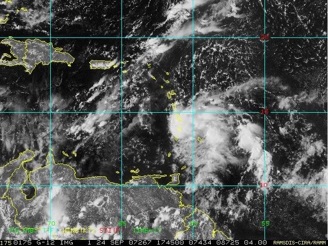
and the feature is really gaining serious burst of convection on NW course...keep watching it all carib residents don't let your guard down! :wink:
http://www.ssd.noaa.gov/goes/flt/t2/loop-rb.html
0 likes   

User avatar
Thunder44
Category 5
Category 5
Posts: 5922
Age: 44
Joined: Mon Jun 09, 2003 7:53 pm
Location: New York City

Re:

#229 Postby Thunder44 » Mon Sep 24, 2007 1:24 pm

gatorcane wrote:someone confirm with me that this invest is clearly looking better than this morning.

I don't think I am seeing things -- it has really blown up over the past several hours.


It does look better on satellite imagery than this morning.
0 likes   

User avatar
ronjon
Category 5
Category 5
Posts: 4822
Joined: Fri Aug 19, 2005 5:17 pm
Location: Hernando Beach, FL

Re: INVEST 97L : Near Windward Islands : Discussions & Images

#230 Postby ronjon » Mon Sep 24, 2007 1:24 pm

From HPC Final Discussion Today:

SOUTHEAST...
A FRONTAL ZONE HANGS UP OFFSHORE THE SOUTHEAST WHILE A MID TO
UPPER CYCLONE APPROACHES FROM THE EAST THIS WEEKEND. THERE IS ALSO THE POTENTIAL OF A TROPICAL LOW MOVING ACROSS SOUTH FLORIDA IN THIS TIME FRAME...WHICH COULD SET UP A PRECIPITATION PATTERN SIMILAR TO WHAT TRANSPIRED ON THE 20TH AND 21ST WHEN THE SEEDLING TO TROPICAL DEPRESSION 10 MOVED THROUGH. POINTS FOR THE SURFACE LOW WERE COORDINATED WITH NHC.

Hmmm...talking about 97L? :eek:
0 likes   

Derek Ortt

#231 Postby Derek Ortt » Mon Sep 24, 2007 1:29 pm

the convection appears to be associated with an outflow boundary today... not impressed with it at all
0 likes   

User avatar
Evil Jeremy
S2K Supporter
S2K Supporter
Posts: 5463
Age: 32
Joined: Mon Apr 10, 2006 2:10 pm
Location: Los Angeles, CA

Re: INVEST 97L : Near Windward Islands : Discussions & Images

#232 Postby Evil Jeremy » Mon Sep 24, 2007 1:33 pm

Derek, what are the chances of this forming, and also the chances of it moving towards SFL?
0 likes   

Derek Ortt

#233 Postby Derek Ortt » Mon Sep 24, 2007 1:34 pm

I'd say 10-20 percent... only slightly above average
0 likes   

User avatar
cycloneye
Admin
Admin
Posts: 145294
Age: 68
Joined: Thu Oct 10, 2002 10:54 am
Location: San Juan, Puerto Rico

Re: INVEST 97L : Near Windward Islands : Discussions & Images

#234 Postby cycloneye » Mon Sep 24, 2007 1:37 pm

So nothing to worrie about in Puerto Rico?
0 likes   

Derek Ortt

#235 Postby Derek Ortt » Mon Sep 24, 2007 1:39 pm

could get some severe thunderstorms from this and possible tornadoes. There is high wind shear just to the west. Harvey in 1999 produced many tornadoes in a high shear environment over SF
0 likes   

flwxwatcher
Category 4
Category 4
Posts: 926
Joined: Wed May 16, 2007 3:35 pm
Location: Central Florida

Re: INVEST 97L : Near Windward Islands : Discussions & Images

#236 Postby flwxwatcher » Mon Sep 24, 2007 1:42 pm

0 likes   

User avatar
fci
S2K Supporter
S2K Supporter
Posts: 3324
Joined: Tue Sep 14, 2004 10:29 am
Location: Lake Worth, FL

Re: INVEST 97L : Near Windward Islands : Discussions & Images

#237 Postby fci » Mon Sep 24, 2007 1:45 pm

flwxwatcher wrote:If the GFS is correct the upper level winds around Florida look to become more hostile in the 5 to 6 day range.

http://www.nco.ncep.noaa.gov/pmb/nwprod/analysis/carib/gfs/12/images/gfs_200_120l.gif


http://www.nco.ncep.noaa.gov/pmb/nwprod/analysis/carib/gfs/12/images/gfs_200_144l.gif

Oh I just LOVE those HOSTILE winds that have been protecting us this season!!! :cheesy:
0 likes   

Sanibel
Category 5
Category 5
Posts: 10375
Joined: Mon Aug 30, 2004 11:06 pm
Location: Offshore SW Florida

Re: INVEST 97L : Near Windward Islands : Discussions & Images

#238 Postby Sanibel » Mon Sep 24, 2007 1:46 pm

Watch red dot IR. Should develop if it doesn't get sheared or crash into any large island.
0 likes   

User avatar
Gustywind
Category 5
Category 5
Posts: 12334
Joined: Mon Sep 03, 2007 7:29 am
Location: Baie-Mahault, GUADELOUPE

#239 Postby Gustywind » Mon Sep 24, 2007 1:52 pm

Rain with thunder on Martiniqua right now 0230 pm pressure at 1011hpa winds from nnw at 5 kt 94% humidity
http://weather.noaa.gov/weather/current/TFFF.html
0 likes   

User avatar
HURAKAN
Professional-Met
Professional-Met
Posts: 46086
Age: 38
Joined: Thu May 20, 2004 4:34 pm
Location: Key West, FL
Contact:

#240 Postby HURAKAN » Mon Sep 24, 2007 1:59 pm

Image
0 likes   


Return to “2007”

Who is online

Users browsing this forum: No registered users and 15 guests