As for 94L...I agree with what has been said. It looks to mainly be a rain event with a chance that it could spin up a LLC and be called a TD or TS right before landfall. Worst case scenario, IMO, is for this to spin up to a strong TS or weak Cat. 1 (similar to Humberto), but I think that is unlikely right now. Either way, it appears likely that somewhere in TX or LA could be looking at serious flooding issues out of this mess.
Tropical Depression LORENZO: Discussions & Images
Moderator: S2k Moderators
-
Extremeweatherguy

- Category 5

- Posts: 11095
- Joined: Mon Oct 10, 2005 8:13 pm
- Location: Florida
Re: INVEST 94L: Gulf of Mexico: Discussions & Images
As for 94L...I agree with what has been said. It looks to mainly be a rain event with a chance that it could spin up a LLC and be called a TD or TS right before landfall. Worst case scenario, IMO, is for this to spin up to a strong TS or weak Cat. 1 (similar to Humberto), but I think that is unlikely right now. Either way, it appears likely that somewhere in TX or LA could be looking at serious flooding issues out of this mess.
0 likes

-
Matt-hurricanewatcher
Re: INVEST 94L: Gulf of Mexico: Discussions & Images
I remember the last surface trough, it exploded into a "powerful" cyclone right off the coast of texas. Don't take your eyes off this...Because the trough is pretty sharp, at least as sharp as the one that formed the LLC on humberto. Yes the shear is stronger, but Alison 2001 I believe formed this way. It is not out of the question.
0 likes
-
eaglegirl

- S2K Supporter

- Posts: 60
- Joined: Sun Sep 09, 2007 10:14 am
- Location: Tallahassee, FL
- Contact:
WHUS52 KTBW 231902
SMWTBW
GMZ830-850-853-232000-
/O.NEW.KTBW.MA.W.0124.070923T1901Z-070923T2000Z/
BULLETIN - IMMEDIATE BROADCAST REQUESTED
SPECIAL MARINE WARNING
NATIONAL WEATHER SERVICE TAMPA BAY AREA - RUSKIN FL
301 PM EDT SUN SEP 23 2007
THE NATIONAL WEATHER SERVICE IN RUSKIN HAS ISSUED A
* SPECIAL MARINE WARNING FOR...
COASTAL WATERS FROM ENGLEWOOD TO TARPON SPRINGS FL OUT 20 NM.
INCLUDING THE TAMPA BAY WATERS.
COASTAL WATERS FROM TARPON SPRINGS TO SUWANNEE RIVER FL OUT 20 NM.
* UNTIL 400 PM EDT
* AT 301 PM EDT...NATIONAL WEATHER SERVICE DOPPLER RADAR INDICATED AN
AREA OF STRONG THUNDERSTORMS...WITH WIND GUSTS OF 34 KNOTS OR
GREATER...FROM 7 MILES EAST OF PORT RICHEY TO 5 MILES EAST OF TERRA
CEIA BAY...MOVING WEST AT 10 KNOTS.
* THE THUNDERSTORMS WILL BE NEAR...
TERRA CEIA BAY BY 320 PM EDT.
ANNA MARIA ISLAND BY 345 PM EDT.
DUNEDIN BY 400 PM EDT.
STRONG THUNDERSTORMS CAN PRODUCE WATERSPOUTS WITH LITTLE OR NO
ADVANCE WARNING. SEEK SAFETY IMMEDIATELY!
MARINERS CAN ALSO EXPECT LOCALLY HIGH WAVES...DANGEROUS LIGHTNING...
AND TORRENTIAL RAIN. SEEK SAFETY IMMEDIATELY.
PLEASE REPORT WATERSPOUTS OR FUNNEL CLOUDS...WINDS OF 34 KNOTS OR
HIGHER...HAIL THE SIZE OF PENNIES OR LARGER...AND ANY VESSEL DAMAGE
TO YOUR NATIONAL WEATHER SERVICE IN RUSKIN BY CALLING 813-645-2323.
&&
LAT...LON 2836 8294 2831 8270 2786 8284 2785 8275
2772 8267 2772 8266 2787 8262 2796 8274
2805 8271 2806 8267 2800 8257 2775 8246
2753 8257 2755 8246 2751 8245 2747 8249
2749 8263 2739 8256 2742 8281 2761 8295
TIME...MOT...LOC 1901Z 130DEG 10KT 2824 8262 2801 8266
2781 8254 2753 8253
$$
57
0 likes
-
Matt-hurricanewatcher
Re: INVEST 94L: Gulf of Mexico: Discussions & Images
There is a elongated LLC over the northern Yucatan. Land obs show it slowly moving northwestward...Once that gets over water, then we will need to start watching.
0 likes
-
JonathanBelles
- Professional-Met

- Posts: 11430
- Age: 35
- Joined: Sat Dec 24, 2005 9:00 pm
- Location: School: Florida State University (Tallahassee, FL) Home: St. Petersburg, Florida
- Contact:
That line went right around me, i might get drizzle
http://radar.weather.gov/ridge/radar.ph ... 11&loop=no
http://radar.weather.gov/ridge/radar.ph ... 11&loop=no
0 likes
-
lrak

- S2K Supporter
- Posts: 1770
- Age: 59
- Joined: Thu Jun 21, 2007 2:48 pm
- Location: Corpus Christi, TX
Re: INVEST 94L: Gulf of Mexico: Discussions & Images
Matt-hurricanewatcher wrote:There is a elongated LLC over the northern Yucatan. Land obs show it slowly moving northwestward...Once that gets over water, then we will need to start watching.
I think it looks quite compact compared to its strength. No?
0 likes
-
Bailey1777
- S2K Supporter
- Posts: 962
- Joined: Mon Jul 31, 2006 6:23 pm
- Location: Houston, Texas
-
Stratosphere747
- Category 5
- Posts: 3772
- Joined: Thu Sep 11, 2003 8:34 pm
- Location: Surfside Beach/Freeport Tx
- Contact:
-
Portastorm

- Storm2k Moderator

- Posts: 9955
- Age: 63
- Joined: Fri Jul 11, 2003 9:16 am
- Location: Round Rock, TX
- Contact:
Re:
Stratosphere747 wrote:I have a feeling that there will be one less invest in the near future.....
I'm with you on this one Strat ... just don't see anything there that suggests were even remotely close to a tropical cyclone forming. Very sharp, healthy trough ... yes! Something more than that ... eh, nope.
I wish it would give us some rain here in south central Texas but we're going to be on the wrong side of this thing.
0 likes
-
HURAKAN

- Professional-Met
- Posts: 46084
- Age: 39
- Joined: Thu May 20, 2004 4:34 pm
- Location: Key West, FL
- Contact:
Re:
Stratosphere747 wrote:I have a feeling that there will be one less invest in the near future.....
Something that I learned from Humberto is that until everything is overland, anything can happen!
0 likes
Re: INVEST 94L: Gulf of Mexico: Discussions & Images
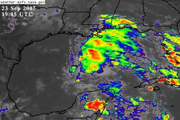
You can see the latest swirl coming off the mainland pretty easily http://wwwghcc.msfc.nasa.gov/cgi-bin/get-goes?satellite=GOES-E%20CONUS&lat=21&lon=-89.5&zoom=1&type=Animation&info=vis. And I have been watching the shear machine in the WV loop. Seems to be getting to be a bit less in the souther gulf.
0 likes


Re: INVEST 94L: Gulf of Mexico: Discussions=5:30 PM TWO Shortly
Is this invest what's been causing all the rain in northwest Florida today? It seems to have been coming in off the gulf all day. It's pouring out right now.
0 likes
Re: INVEST 94L: Gulf of Mexico: Discussions=5:30 PM TWO Shortly
Lot's of rain for Southeast, Texas? What's the time period for this? I've been away from the p.c. for 2 1/2 days and this is the first place I came. 
0 likes
-
HURAKAN
- Professional-Met
- Posts: 46084
- Age: 39
- Joined: Thu May 20, 2004 4:34 pm
- Location: Key West, FL
- Contact:
659
ABNT20 KNHC 232129
TWOAT
TROPICAL WEATHER OUTLOOK
NWS TPC/NATIONAL HURRICANE CENTER MIAMI FL
530 PM EDT SUN SEP 23 2007
FOR THE NORTH ATLANTIC...CARIBBEAN SEA AND THE GULF OF MEXICO...
THE NATIONAL HURRICANE CENTER IS ISSUING ADVISORIES ON
SUBTROPICAL STORM JERRY...LOCATED ABOUT 1060 MILES WEST OF THE
AZORES.
DISORGANIZED SHOWERS AND THUNDERSTORMS EXTENDING FROM THE YUCATAN
PENINSULA NORTHWARD ACROSS THE CENTRAL GULF OF MEXICO ARE PRIMARILY
ASSOCIATED WITH A SURFACE TROUGH. THIS SYSTEM REMAINS DISORGANIZED
AND THE RECONNAISSANCE MISSION SCHEDULED TO INVESTIGATE THE AREA
THIS AFTERNOON WAS CANCELED. UPPER-LEVEL WINDS OVER THIS SYSTEM
ARE CURRENTLY VERY STRONG AND DEVELOPMENT...IF ANY...IS EXPECTED TO
BE SLOW TO OCCUR.
A BROAD AREA OF LOW PRESSURE ASSOCIATED WITH A TROPICAL WAVE IS
LOCATED ABOUT 300 MILES EAST OF THE WINDWARD ISLANDS. THIS SYSTEM
HAS CHANGED LITTLE IN ORGANIZATION TODAY...BUT COULD STILL DEVELOP
INTO A TROPICAL DEPRESSION DURING THE NEXT DAY OR SO AS IT MOVES
WEST-NORTHWESTWARD TOWARD THE WINDWARD ISLANDS.
AN AREA OF LOW PRESSURE ASSOCIATED WITH A TROPICAL WAVE IS LOCATED
ABOUT 650 MILES SOUTH-SOUTHWEST OF THE CAPE VERDE ISLANDS. THIS
SYSTEM REMAINS WELL ORGANIZED AND CONDITIONS APPEAR FAVORABLE FOR IT
TO BECOME A TROPICAL DEPRESSION DURING THE NEXT DAY OR TWO AS IT
MOVES WESTWARD AT ABOUT 15 MPH.
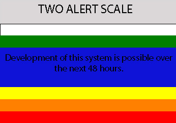
ELSEWHERE...TROPICAL CYCLONE FORMATION IS NOT EXPECTED DURING THE
NEXT 48 HOURS.
PUBLIC ADVISORIES ON JERRY ARE ISSUED UNDER WMO HEADER WTNT31 AND
UNDER AWIPS HEADER MIATCPAT1. FORECAST/ADVISORIES ON JERRY ARE
ISSUED UNDER WMO HEADER WTNT21 AND UNDER AWIPS HEADER MIATCMAT1.
$$
FORECASTER BROWN
ABNT20 KNHC 232129
TWOAT
TROPICAL WEATHER OUTLOOK
NWS TPC/NATIONAL HURRICANE CENTER MIAMI FL
530 PM EDT SUN SEP 23 2007
FOR THE NORTH ATLANTIC...CARIBBEAN SEA AND THE GULF OF MEXICO...
THE NATIONAL HURRICANE CENTER IS ISSUING ADVISORIES ON
SUBTROPICAL STORM JERRY...LOCATED ABOUT 1060 MILES WEST OF THE
AZORES.
DISORGANIZED SHOWERS AND THUNDERSTORMS EXTENDING FROM THE YUCATAN
PENINSULA NORTHWARD ACROSS THE CENTRAL GULF OF MEXICO ARE PRIMARILY
ASSOCIATED WITH A SURFACE TROUGH. THIS SYSTEM REMAINS DISORGANIZED
AND THE RECONNAISSANCE MISSION SCHEDULED TO INVESTIGATE THE AREA
THIS AFTERNOON WAS CANCELED. UPPER-LEVEL WINDS OVER THIS SYSTEM
ARE CURRENTLY VERY STRONG AND DEVELOPMENT...IF ANY...IS EXPECTED TO
BE SLOW TO OCCUR.
A BROAD AREA OF LOW PRESSURE ASSOCIATED WITH A TROPICAL WAVE IS
LOCATED ABOUT 300 MILES EAST OF THE WINDWARD ISLANDS. THIS SYSTEM
HAS CHANGED LITTLE IN ORGANIZATION TODAY...BUT COULD STILL DEVELOP
INTO A TROPICAL DEPRESSION DURING THE NEXT DAY OR SO AS IT MOVES
WEST-NORTHWESTWARD TOWARD THE WINDWARD ISLANDS.
AN AREA OF LOW PRESSURE ASSOCIATED WITH A TROPICAL WAVE IS LOCATED
ABOUT 650 MILES SOUTH-SOUTHWEST OF THE CAPE VERDE ISLANDS. THIS
SYSTEM REMAINS WELL ORGANIZED AND CONDITIONS APPEAR FAVORABLE FOR IT
TO BECOME A TROPICAL DEPRESSION DURING THE NEXT DAY OR TWO AS IT
MOVES WESTWARD AT ABOUT 15 MPH.
ELSEWHERE...TROPICAL CYCLONE FORMATION IS NOT EXPECTED DURING THE
NEXT 48 HOURS.
PUBLIC ADVISORIES ON JERRY ARE ISSUED UNDER WMO HEADER WTNT31 AND
UNDER AWIPS HEADER MIATCPAT1. FORECAST/ADVISORIES ON JERRY ARE
ISSUED UNDER WMO HEADER WTNT21 AND UNDER AWIPS HEADER MIATCMAT1.
$$
FORECASTER BROWN
0 likes


Upper Level Winds
What are the chances that the upper-level winds will subside within the next 24-48 hrs and allow this thing to grow?
--Ross

--Ross
0 likes
-
jasons2k

- Storm2k Executive

- Posts: 8290
- Age: 52
- Joined: Wed Jul 06, 2005 12:32 pm
- Location: The Woodlands, TX
Re: 94L: Gulf of Mexico: Discussions=5:30 PM TWO at page 9
AREA FORECAST DISCUSSION
NATIONAL WEATHER SERVICE HOUSTON/GALVESTON TX
300 PM CDT SUN SEP 23 2007
.DISCUSSION...
APPEARS THE WORK WEEK FCST WILL HINGE ON THE FUTURE EVOLUTION OF THE
SFC TROF CURRENTLY EXTENDING FROM CARIBBEAN INTO THE NCNTL GULF.
EXPECT IT TO MAKE VERY SLOW WWD PROGRESS THE NEXT COUPLE DAYS AND
NRN PERIPHERY OF THE TROF AXIS SHOULD BE OFF THE UPPER TX COAST
SOMETIME LATE TUES. BULK OF MOISTURE REMAINS ON THE EAST SIDE OF
THE TROF AXIS SO UNTIL IT GETS CLOSER TO THE REGION RAIN CHANCES
SHOULD BE FAIRLY LOW. MODELS SHOWING VARIOUS OPINIONS REGARDING THE
POTENTIAL FOR TROPICAL DEVELOPMENT. UPPER SHEAR WILL REMAIN STRONG
ACROSS THE WRN 1/3 OF THE GULF THRU MON BUT NOTICEABLY DECREASES
BEGINNING ON TUES. SOME KEEP THE SFC HIGH STRONG ENOUGH ALONG THE
GULF COAST STATES TO KEEP ANYTHING THAT MAY DEVELOP IN THE SW GULF.
OTHERS ARE NOT AS BULLISH REGARDING THE SLIGHTLY STRONGER RIDGE. ONE
WAY OR THE OTHER LITTLE CIRCULATIONS DEVELOPING WITHIN CONVECTION
ASSOCIATED WITH THE TROF CANNOT BE RULED OUT. PREFER NOT TO BASE THE
FCST ON ONE SPECIFIC MODEL UNTIL IF/WHEN A WELL DEFINED & LONGER
LASTING CIRCULATION DEVELOPS. IN THE MEANTIME...WILL BROADBRUSH POPS
20% WEST TO 40% EAST ACROSS MOST OF SE TX (ESP E OF I-45) TUES AND
BEYOND AND WILL TWEAK UP/DOWN AS THE PICTURE BECOMES MORE CLEAR.
WEAK FRONTAL BOUNDARY MOVES INTO THE AREA LATE THURS AND COULD END
UP HANGING UP NEAR THE COAST AS THE SFC HIGH BEHIND IT QUICKLY MOVES
OFF TO THE EAST.
http://www.srh.noaa.gov/productview.php ... n=0&max=61
0 likes
Who is online
Users browsing this forum: No registered users and 130 guests