Tropical Depression TEN: Discussions & Images
Moderator: S2k Moderators

Re: INVEST 93L: Near Florida: Discussions & Images
Another rain bust for South Florida. Lake O still at 9.64ft. All the rain like I said last night is up in North and Central Florida.No rain for us down here. Its the story of the summer,no rain again.Real tough water restrictions is a good bet this winter.
0 likes

Re:
HURAKAN wrote:In reality the lowest pressure being reported is in Freeport with 1010.8 mb.
1010.1mb in Virgina Key
http://www.ndbc.noaa.gov/station_page.php?station=VAKF1
0 likes

-
HURAKAN

- Professional-Met

- Posts: 46084
- Age: 39
- Joined: Thu May 20, 2004 4:34 pm
- Location: Key West, FL
- Contact:
Re: INVEST 93L: Near Florida: Discussions & Images
boca wrote:Another rain bust for South Florida. Lake O still at 9.64ft. All the rain like I said last night is up in North and Central Florida.No rain for us down here. Its the story of the summer,no rain again.Real tough water restrictions is a good bet this winter.
Don't know if you have noticed that most of the convection is to the east of the circulation. As the system moves towards the GOM it should provide heavy rainfall to Florida.
0 likes

Re:
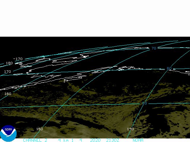
HURAKAN wrote:Latest:
Looks like a boomerang!!!
It does look like a boomerang, I don't see any west movement with 93L. Yes the ULL is moving SW, but the low South of West Palm is just sitting and spinning.
0 likes
Re: INVEST 93L: Near Florida: Discussions & Images
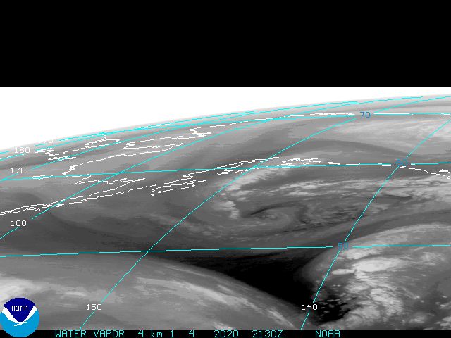
It looks fairly organized on satellite, but, most of the weather is north of 27N, so, even if it does move into the Gulf, most of this will already be inland along the Gulf coast before moving completely inland...
http://www.goes.noaa.gov/browsh.html
http://www.goes.noaa.gov/browsh.html
0 likes
-
stormchazer

- Category 5

- Posts: 2462
- Joined: Fri Aug 29, 2003 12:00 pm
- Location: Lakeland, Florida
- Contact:
Re: INVEST 93L: Near Florida: Discussions & Images
boca wrote:Another rain bust for South Florida. Lake O still at 9.64ft. All the rain like I said last night is up in North and Central Florida.No rain for us down here. Its the story of the summer,no rain again.Real tough water restrictions is a good bet this winter.
Hopefully Lake O will see some relief because most ofthe rain in Central Florida drains into the Chain of Lakes, and I believe the chain drains ultimately to Lake O. Also with the days heating, storms may develop further south with all the instability in the atmosphere.
I am trying to give you some bright sides to look at.
0 likes

-
Derek Ortt

Re: INVEST 93L: Near Florida: Discussions & Images
HURAKAN wrote:boca wrote:Another rain bust for South Florida. Lake O still at 9.64ft. All the rain like I said last night is up in North and Central Florida.No rain for us down here. Its the story of the summer,no rain again.Real tough water restrictions is a good bet this winter.
Don't know if you have noticed that most of the convection is to the east of the circulation. As the system moves towards the GOM it should provide heavy rainfall to Florida.
quote]
Convection looks all North and Northeast of the center and not East
The rain we get looks to me to be the afternoon heating T-Storms that will move East and Northeast BEHIND this system.
Derek:
Selfishly we would like some rain for our lawns too!
And the little lakes in our communities that supply the water to irrigate our lawns.
0 likes

-
Stratosphere747
- Category 5
- Posts: 3772
- Joined: Thu Sep 11, 2003 8:34 pm
- Location: Surfside Beach/Freeport Tx
- Contact:
Re: INVEST 93L: Near Florida: Discussions & Images
It seems to finally have moved after being somewhat stationary over the last 12hrs.
0 likes

Re: INVEST 93L: Near Florida: Discussions & Images
boca wrote:Another rain bust for South Florida. Lake O still at 9.64ft. All the rain like I said last night is up in North and Central Florida.No rain for us down here. Its the story of the summer,no rain again.Real tough water restrictions is a good bet this winter.
Boca, don't give up yet - plenty of storm to go the next 2-3 days. Some dry air has wrapped into the circulation from the west and north over south Florida. As the entire system moves west, winds will eventually shift to a southerly direction bringing up a deep plume of tropical moisture. Both the GFS and NAM show that the peninsula will pick up some heavy rains when this happens.
0 likes
Re: INVEST 93L: Near Florida: Discussions & Images
Yes, Hurakan, the ULL is now off the SW FL coast.
0 likes
Re: INVEST 93L: Near Florida: Discussions & Images
Can someone save me some time and tell me if this system is giong to develop from the ULL or that convection to the N and E of the ULL? I see some T-storms starting to form very near the center of the ULL and I'm having a hard time seeing how this LLC is gonna book it as far west as the RECON flight has it forecast.
0 likes
-
gatorcane

- S2K Supporter

- Posts: 23708
- Age: 48
- Joined: Sun Mar 13, 2005 3:54 pm
- Location: Boca Raton, FL
Folks this is just my opinion but I don't think 93L is going to develop at least anytime soon. I did think there was a chance yesterday but it is not impressing me at all this morning. The ULL has got it right now.
I continue to look at Ex-Ingrid which is now in a marginally favorable environment and is starting really blowup convection (some of it is near the "LLC" now) as she moves WNW north of Puerto Rico. This is where she may make her run and what I have been calling for for the past 5 days.
I continue to look at Ex-Ingrid which is now in a marginally favorable environment and is starting really blowup convection (some of it is near the "LLC" now) as she moves WNW north of Puerto Rico. This is where she may make her run and what I have been calling for for the past 5 days.
0 likes

Re: INVEST 93L: Near Florida: Discussions & Images
What do you guys think about the SIZE of this thing. It looks when it gets going it could be a floyd or Katrina sized monster...not strength that is....I am talk about real estate covered.
If GFS is right it would seems TS winds at least would effect everyone from Destin to Houma. Of course it also keeps it real close to the coast almost Elena like in hugging the NC Gulf Coast from the Panahandle right into Louisiana. Actually if this Morning GFS panned out I could see the effects on MS/LA/AL being similiar to Elena, albiet with most likely, LESS WIND. The surge would not be a huge issue though I beleive becase of the angle of approach. This was the case in Elena(also a fast mover so didnt have time to push much surge). I am a little unnerved by...GFS shear forecast(i.e. cant find any shear for the 48 hours up until landfall)...and the nice signature on the GFS...which could barely see felix and dean. my assumption is that the signature on there is much better due to the fact it is initially cold core...but who knows.
If GFS is right it would seems TS winds at least would effect everyone from Destin to Houma. Of course it also keeps it real close to the coast almost Elena like in hugging the NC Gulf Coast from the Panahandle right into Louisiana. Actually if this Morning GFS panned out I could see the effects on MS/LA/AL being similiar to Elena, albiet with most likely, LESS WIND. The surge would not be a huge issue though I beleive becase of the angle of approach. This was the case in Elena(also a fast mover so didnt have time to push much surge). I am a little unnerved by...GFS shear forecast(i.e. cant find any shear for the 48 hours up until landfall)...and the nice signature on the GFS...which could barely see felix and dean. my assumption is that the signature on there is much better due to the fact it is initially cold core...but who knows.
0 likes
Who is online
Users browsing this forum: No registered users and 35 guests