000
ABNT20 KNHC 190211
TWOAT
TROPICAL WEATHER OUTLOOK
NWS TPC/NATIONAL HURRICANE CENTER MIAMI FL
1030 PM EDT TUE SEP 18 2007
FOR THE NORTH ATLANTIC...CARIBBEAN SEA AND THE GULF OF MEXICO...
A LARGE AREA OF DISTURBED WEATHER OVER THE WESTERN ATLANTIC...
NORTHERN BAHAMAS...AND THE EAST COAST OF FLORIDA IS ASSOCIATED WITH
A TROPICAL WAVE INTERACTING WITH AN UPPER-LEVEL LOW. THERE ARE NO
SIGNS OF ORGANIZATION AT THIS TIME. HOWEVER...SURFACE PRESSURES
ARE GRADUALLY FALLING AND ENVIRONMENTAL CONDITIONS APPEAR FAVORABLE
FOR A SUBTROPICAL OR A TROPICAL CYCLONE TO FORM OVER THE NEXT DAY
OR TWO...AS THE DISTURBANCE MOVES WESTWARD OVER FLORIDA AND INTO
THE GULF OF MEXICO. REGARDLESS OF DEVELOPMENT...THIS SYSTEM WILL
LIKELY BRING SHOWERS...SQUALLS...AND LOCALLY HEAVY RAINS OVER
PORTION OF FLORIDA DURING THE NEXT DAY OR TWO.
$$
FORECASTER RHOME
Tropical Depression TEN: Discussions & Images
Moderator: S2k Moderators

Re: INVEST 93L: East of South Florida: Discussion & Images
Jagno wrote:TSmith274 wrote:Sean in New Orleans wrote:It's getting kinda late in the season for a monster storm, though.
Come on now. That just isn't true.
Excuse me, remember Rita on September 24th??????? Not monster but definitely major.
Absolutely. I'd call her a monster. Suprising that someone would suggest it is too late for a "monster storm".
0 likes

Re: INVEST 93L: East of South Florida: Discussion & Images
Sean in New Orleans wrote:It's getting kinda late in the season for a monster storm, though.
*speechless*
Ok, no I'm not. It is September 19! We are 1 week past the peak of the season. It is like saying "It is too early in the season for a monster storm" on September 3.
0 likes
-
Air Force Met
- Military Met

- Posts: 4372
- Age: 57
- Joined: Tue Jul 08, 2003 9:30 am
- Location: Roan Mountain, TN
Re: INVEST 93L: East of South Florida: Discussion & Images
TSmith274 wrote:Sean in New Orleans wrote:It's getting kinda late in the season for a monster storm, though.
Come on now. That just isn't true.
Yeah...Rita '05...Wilma...
I don't have the time to list all the one's that prove that statement wrong.
0 likes
-
MiamiensisWx
Re: INVEST 93L: East of South Florida: Discussion & Images
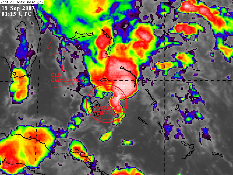
Do you think there is a chance that the LLC could relocate closer to the convection in the central Bahamas? The old LLC (near Air Force Met's position) may die out while a new sfc low forms slightly further E or ESE. It doesn't look like convection will refire (in the immediate term) near the old low-level circulation, so a center relocation seems plausible. Additionally, it looks like the low-level convergence has greatly diminished near the original LLC, while I can see a small area of increasing convergence near the E Bahamas. If my interpretation of this chart (click here) is correct, the central Bahamas may become more conducive for a possible new LLC. Can any pros or others answer my question?
Evidence:
http://www.ssd.noaa.gov/goes/east/tatl/loop-ir2.html
Hypothesis:
Click here
Thanks in advance!
Evidence:
http://www.ssd.noaa.gov/goes/east/tatl/loop-ir2.html
Hypothesis:
Click here
Thanks in advance!
Last edited by MiamiensisWx on Tue Sep 18, 2007 9:19 pm, edited 1 time in total.
0 likes
Re: INVEST 93L: Discussion & Images=10:30 PM TWO at page 25
The "no signs of organization at this time" comment is rather interesting from the TWO.
Count me in the "believe it when I see it" category.
Count me in the "believe it when I see it" category.
0 likes
-
Air Force Met
- Military Met
- Posts: 4372
- Age: 57
- Joined: Tue Jul 08, 2003 9:30 am
- Location: Roan Mountain, TN
Re: INVEST 93L: East of South Florida: Discussion & Images
PTrackerLA wrote:I really don't see much in the way of a low-level circulation. Convection has greatly diminished...who knows maybe nothing will come out of this after all. (wishful thinking I remember well what pre-Humberto looked like)
I do think the low has filled tonight...it may have even opened up into a wave again.
0 likes
-
Brent
- S2K Supporter

- Posts: 38790
- Age: 37
- Joined: Sun May 16, 2004 10:30 pm
- Location: Tulsa Oklahoma
- Contact:
Re: INVEST 93L: Discussion & Images=10:30 PM TWO at page 25
Tropics_Dude83 wrote:The "no signs of organization at this time" comment is rather interesting from the TWO.
Count me in the "believe it when I see it" category.
I think it won't develop til after FL.
0 likes
-
Stormcenter
- S2K Supporter
- Posts: 6689
- Joined: Wed Sep 03, 2003 11:27 am
- Location: Houston, TX
Re: INVEST 93L: East of South Florida: Discussion & Images
Air Force Met wrote:TSmith274 wrote:Sean in New Orleans wrote:It's getting kinda late in the season for a monster storm, though.
Come on now. That just isn't true.
Yeah...Rita '05...Wilma...
I don't have the time to list all the one's that prove that statement wrong.
AFM I hate to ask but are you saying that the possibility is there for a storm of that type from this disturbance?
0 likes

Re: INVEST 93L: Discussion & Images=10:30 PM TWO at page 25
The only bouy thats not showing rising pressure is 42023, for whatever that means

0 likes
Re: INVEST 93L: Discussion & Images=10:30 PM TWO at page 25
Here's a question for anyone knowledgable enough to answer:
Has there ever been a baroclinic/cold core system form that later went warm core and developed into a significant hurricane or are systems that generate this way usually modest?
Has there ever been a baroclinic/cold core system form that later went warm core and developed into a significant hurricane or are systems that generate this way usually modest?
0 likes
-
Matt-hurricanewatcher
Re: INVEST 93L: Discussion & Images=10:30 PM TWO at page 25
Tropics_Dude83 wrote:Here's a question for anyone knowledgable enough to answer:
Has there ever been a baroclinic/cold core system form that later went warm core and developed into a significant hurricane or are systems that generate this way usually modest?
Vince 2005, Kyle, Noal 2001, many more...
http://weather.unisys.com/hurricane/atl ... /track.gif
Delta also I think...
Last edited by Matt-hurricanewatcher on Tue Sep 18, 2007 9:33 pm, edited 1 time in total.
0 likes
-
Extremeweatherguy

- Category 5

- Posts: 11095
- Joined: Mon Oct 10, 2005 8:13 pm
- Location: Florida
Re: INVEST 93L: Discussion & Images=10:30 PM TWO at page 25
Well this is not the greatest example, but it was the first I could find..Tropics_Dude83 wrote:Here's a question for anyone knowledgable enough to answer:
Has there ever been a baroclinic/cold core system form that later went warm core and developed into a significant hurricane or are systems that generate this way usually modest?
http://en.wikipedia.org/wiki/User:Storm ... Olga_(2001)
Hurricane Olga in 2001 started as a subtropical storm and transitioned into a 90mph (973mb) hurricane. The only real reason she didn't go beyond 90mph was the fact that the waters were in the 73-75 degree range and it was November with wind shear in the area. Given warmer water and a September environment, I see no reason why a similar storm couldn't explode beyond 90mph and become a Cat. 2+.
BTW: If I find any better examples I will surely post them.
0 likes
-
Sean in New Orleans

- Category 5
- Posts: 1794
- Joined: Thu Aug 28, 2003 7:26 pm
- Location: New Orleans, LA 30.0N 90.0W
- Contact:
I didn't say it COULDN'T happen, but, we are going to start trending downwards. I'm very aware of Rita. It hit my home state. Anything could happen, I just can't see a Katrina or a Rita forming if this storm were to hit SE LA or MS Coast. Now if it tracks across the GOM into Texas, obviously that is more time over water, but, we'll see. No reason to get emotional. It's just something that we are all watching.
0 likes


A weatherman here in Austin said earlier this evening that this will most likely be a Texas storm. And he didn't say if it develops, but when it develops. He was showing 2 highs that would encompass areas either side of an area of Texas from south of Corpus to just east of Galveston, around High Island. Louisiana looks like it will fall under the protection of the high to our east.
I'm just going by what I heard.
I'm just going by what I heard.
0 likes
-
Comanche

- Category 1

- Posts: 381
- Age: 54
- Joined: Wed Jul 06, 2005 9:33 am
- Location: Clear Lake City Texas
Re: INVEST 93L: Discussion & Images=10:30 PM TWO at page 25
JB out with new update. He still leans toward the west solution of Texas or west LA at this point. Also says that it could go the distance to a major although he isn't forecasting that yet.
0 likes

So, are there prospects for copious amounts of rain for Southeast Florida?
We really need the rain and for Lake O to fill to keep us from SERIOUS water restrictions this Winter!
I don't like that our rain chances are only 60% and 50% the next few days.
Is there a chance that we see only just a little rain??
We really need the rain and for Lake O to fill to keep us from SERIOUS water restrictions this Winter!
I don't like that our rain chances are only 60% and 50% the next few days.
Is there a chance that we see only just a little rain??
0 likes

Re: INVEST 93L: East of South Florida: Discussion & Images
TSmith274 wrote:Absolutely. I'd call her a monster. Suprising that someone would suggest it is too late for a "monster storm".
Rita was a large hurricane when it made landfall. It caused a huge scare for us Texans.
0 likes
-
Ed Mahmoud
Re: INVEST 93L: Discussion & Images=10:30 PM TWO at page 25
Jim Cantore going to Jacksonville, FL tomorrow. To report on developing situation.
Up to me, with airport delays, and TSA, and parking, I'd just drive from ATL to JAX with the satellite truck.
Up to me, with airport delays, and TSA, and parking, I'd just drive from ATL to JAX with the satellite truck.
0 likes
Who is online
Users browsing this forum: No registered users and 48 guests