Tropical Depression TEN: Discussions & Images

Moderator: S2k Moderators

Message
Author
User avatar
artist
Category 5
Category 5
Posts: 9792
Joined: Mon Jun 06, 2005 3:26 pm
Location: West Palm

#281 Postby artist » Tue Sep 18, 2007 3:30 pm

http://www.calypsobahamas.com/current_c ... eather.htm
http://www.rockybay.com/webcam_page.htm
http://www.icspet.com/weather/WeatherTest.html
http://oii.net/bbob/MOWwx.htm

some current weather stations form the Abaco;s in the northern Bahamas as well as live web cams.

I have no idea how accurate they all are (or not). :D
0 likes   

User avatar
robbielyn
Category 5
Category 5
Posts: 1298
Joined: Wed May 07, 2003 9:45 am
Location: brooksville, fl

Re: INVEST 93L (ATL): Discussion & Images

#282 Postby robbielyn » Tue Sep 18, 2007 3:31 pm

micktooth wrote:
cpdaman wrote:is vivian brown from TWC a meteorologist or just an on air personality

she keeps saying it is an upper level feature and they are waiting on a possible low level circulation to form

then i read the 205 marine statement talking about a strengthening low near bimini

geez what gives


I wouldn't count on TWC too much. Vivian Brown is ok, much better than Lisa "Gulf of Georgia" Moser from a few years back. :lol:


Wow I remember her but I am surprised you remember her name. I couldn't stand her forecasts. It took twc a long time to remove her thank goodness they did. She had a teleprompter didn't she? I don't know how she messed up like that. I have seen mets make mistakes of course but nothing like that. TWC loses credibility when their on air mets can't be accurate. I like Vivian Brown though. She isn't my favorite, Jim is but she's ok.
0 likes   

User avatar
HURAKAN
Professional-Met
Professional-Met
Posts: 46086
Age: 38
Joined: Thu May 20, 2004 4:34 pm
Location: Key West, FL
Contact:

#283 Postby HURAKAN » Tue Sep 18, 2007 3:31 pm

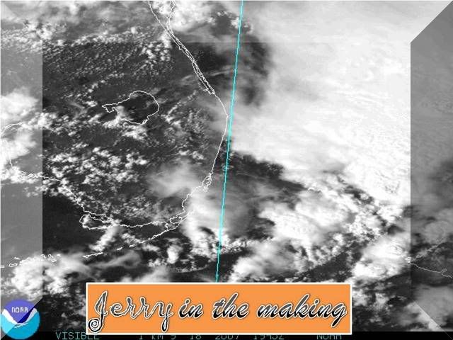
Image
0 likes   

User avatar
gatorcane
S2K Supporter
S2K Supporter
Posts: 23691
Age: 47
Joined: Sun Mar 13, 2005 3:54 pm
Location: Boca Raton, FL

#284 Postby gatorcane » Tue Sep 18, 2007 3:32 pm

still looks to be that the center is not concrete yet...big convection bursts are blowing up now east of the "proposed" LLC .

WE DO NOT want this to get its act together more offshore (like 200+ miles offshore) as it will have more time to get going.
Last edited by gatorcane on Tue Sep 18, 2007 3:33 pm, edited 1 time in total.
0 likes   

User avatar
oyster_reef
Tropical Storm
Tropical Storm
Posts: 123
Joined: Tue Aug 14, 2007 3:05 pm
Location: Alabama

Re: INVEST 93L (ATL): Discussion & Images

#285 Postby oyster_reef » Tue Sep 18, 2007 3:32 pm

Pearl River wrote:CarverSteve wrote:

All i know is..Long beach mississippi does not even need a low end hurricane.I was down there in 2005 to help with some of the clean-up....All i can say is WOW...Neve seen such destruction.And i'm sure they still have a long ways to go


Yep...Long Beach and Waveland. I pass them both everyday on Hwy 90 and it still brings a tear to the eye's.


the whole MS coast. I drove down pascagoula beach today. very sad sight.
0 likes   

User avatar
wzrgirl1
S2K Supporter
S2K Supporter
Posts: 1325
Joined: Sat Sep 04, 2004 6:44 am
Location: Pembroke Pines, Florida

Re: INVEST 93L (ATL): Discussion & Images

#286 Postby wzrgirl1 » Tue Sep 18, 2007 3:34 pm

where exactly is the "proposed" LLC
0 likes   

User avatar
Tampa Bay Hurricane
Category 5
Category 5
Posts: 5597
Age: 37
Joined: Fri Jul 22, 2005 7:54 pm
Location: St. Petersburg, FL

Re:

#287 Postby Tampa Bay Hurricane » Tue Sep 18, 2007 3:34 pm

gatorcane wrote:still looks to be that the center is not concrete yet...big convection bursts are blowing up now east of the "proposed" LLC .

WE DO NOT want this to get its act together more offshore (like 200+ miles offshore) as it will have more time to get going.


It may develop further offshore in an attempt to avoid interaction
with the close by ULL
0 likes   

User avatar
canegrl04
Category 5
Category 5
Posts: 2486
Joined: Thu Aug 26, 2004 5:37 pm
Location: Texas

Re: INVEST 93L (ATL): Discussion & Images

#288 Postby canegrl04 » Tue Sep 18, 2007 3:35 pm

Using Humberto as just one example,intensity is very near impossible to predict.If this becomes Jerry,depending on the variable,he could be anywhere from a TS to cat 3 when it hits land.
Last edited by canegrl04 on Tue Sep 18, 2007 3:36 pm, edited 1 time in total.
0 likes   

User avatar
artist
Category 5
Category 5
Posts: 9792
Joined: Mon Jun 06, 2005 3:26 pm
Location: West Palm

#289 Postby artist » Tue Sep 18, 2007 3:35 pm

area buoy reports and ships reports -

http://www.ndbc.noaa.gov/radial_search. ... E&dist=250
This should be on the north side, I think.
0 likes   

User avatar
fci
S2K Supporter
S2K Supporter
Posts: 3324
Joined: Tue Sep 14, 2004 10:29 am
Location: Lake Worth, FL

Re: INVEST 93L (ATL): Discussion & Images

#290 Postby fci » Tue Sep 18, 2007 3:37 pm

gatorcane wrote:Yes, that is why I think the NHC may consider tropical storm warnings for parts of Florida tonight.

Just my opinion.

Another thing to consider is the possibility of tornado watches/warnings with all the vorticity in the atmosphere....


Seems like everything is off shore now after we got some pretty strong cells here late this morning.

I don't see ANY watches or warnings this evening here.
0 likes   

User avatar
HURAKAN
Professional-Met
Professional-Met
Posts: 46086
Age: 38
Joined: Thu May 20, 2004 4:34 pm
Location: Key West, FL
Contact:

#291 Postby HURAKAN » Tue Sep 18, 2007 3:37 pm

Station SPGF1

4:00 pm ENE ( 57 deg ) 23 kts
3:50 pm ENE ( 60 deg ) 26 kts
3:40 pm NE ( 56 deg ) 28 kts
3:30 pm NE ( 55 deg ) 27 kts
3:20 pm NE ( 51 deg ) 26 kts
3:10 pm NE ( 54 deg ) 26 kts

Impressive.
0 likes   

BrSpinDoc
Tropical Wave
Tropical Wave
Posts: 3
Joined: Tue Sep 18, 2007 2:22 pm

Re: INVEST 93L (ATL): Discussion & Images

#292 Postby BrSpinDoc » Tue Sep 18, 2007 3:38 pm

I am not a weather person, but the spokesperson for the state agency in charge of hurricane response in Louisiana. I am seeking a little guidance. What affect will this storm have on Louisiana and when? Should we start warning people now?
0 likes   

Stormcenter
S2K Supporter
S2K Supporter
Posts: 6684
Joined: Wed Sep 03, 2003 11:27 am
Location: Houston, TX

Re: INVEST 93L (ATL): Discussion & Images

#293 Postby Stormcenter » Tue Sep 18, 2007 3:38 pm

canegrl04 wrote:Using Humberto as just one example,intensity is very near impossible to predict.If this becomes Jerry,depending on the variable,he could be anywhere from a TS to cat 3 when it hits land.


A Cat. 3 where in Eastern,central or western GOM?
These are the same type of bold statements I heard
for that other East coast TS. We need to keep
things in perspective here.
Last edited by Stormcenter on Tue Sep 18, 2007 3:40 pm, edited 2 times in total.
0 likes   

User avatar
Emmett_Brown
Category 5
Category 5
Posts: 1432
Joined: Wed Aug 24, 2005 9:10 pm
Location: Sarasota FL

Re:

#294 Postby Emmett_Brown » Tue Sep 18, 2007 3:38 pm

HURAKAN wrote:Station SPGF1

4:00 pm ENE ( 57 deg ) 23 kts
3:50 pm ENE ( 60 deg ) 26 kts
3:40 pm NE ( 56 deg ) 28 kts
3:30 pm NE ( 55 deg ) 27 kts
3:20 pm NE ( 51 deg ) 26 kts
3:10 pm NE ( 54 deg ) 26 kts

Impressive.


Where is that station located?
0 likes   

User avatar
robbielyn
Category 5
Category 5
Posts: 1298
Joined: Wed May 07, 2003 9:45 am
Location: brooksville, fl

Re: INVEST 93L (ATL): Discussion & Images

#295 Postby robbielyn » Tue Sep 18, 2007 3:38 pm

canegrl04 wrote:Using Humberto as just one example,intensity is very near impossible to predict.If this becomes Jerry,depending on the variable,he could be anywhere from a TS to cat 3 when it hits land.

You are talking about the the gulf side right? Ain't know way it'll do anything before it gets to the gulf. Wonder how fast it will develop in the gulf and will the west side of fl get the ne quadrant of a ts or worse.
0 likes   

RL3AO
Moderator-Pro Met
Moderator-Pro Met
Posts: 16308
Joined: Thu Jun 14, 2007 10:03 pm
Location: NC

Re: INVEST 93L (ATL): Discussion & Images

#296 Postby RL3AO » Tue Sep 18, 2007 3:39 pm

BrSpinDoc wrote:I am not a weather person, but the spokesperson for the state agency in charge of hurricane response in Louisiana. I am seeking a little guidance. What affect will this storm have on Louisiana and when? Should we start warning people now?


Way to soon to tell.
0 likes   

User avatar
southerngale
Retired Staff
Retired Staff
Posts: 27418
Joined: Thu Oct 10, 2002 1:27 am
Location: Southeast Texas (Beaumont area)

Re: INVEST 93L (ATL): Discussion & Images

#297 Postby southerngale » Tue Sep 18, 2007 3:40 pm

I see the Euro still shows Texas, but the others have trended east, so that has a lot of people around here breathing a little easier. I know it could shift west again, but for now, the trend seems to be east. The trend is your friend, right?

AFM, wxman57, or other mets.... it's hard to believe this could trek west all the way across the GOM and hit Texas (as the Euro shows), without finding a weakness. It's getting late in the season for us. I know Rita did it, so it keeps my guard up, but that was considered pretty late in the season.... surely not another one just 2 years later. I know you can change your mind, but what odds do you put on it doing that? Everyone is asking me questions since I'm the weather geek of the crowd.... can I ease their minds a little?
0 likes   

User avatar
robbielyn
Category 5
Category 5
Posts: 1298
Joined: Wed May 07, 2003 9:45 am
Location: brooksville, fl

Re: INVEST 93L (ATL): Discussion & Images

#298 Postby robbielyn » Tue Sep 18, 2007 3:40 pm

BrSpinDoc wrote:I am not a weather person, but the spokesperson for the state agency in charge of hurricane response in Louisiana. I am seeking a little guidance. What affect will this storm have on Louisiana and when? Should we start warning people now?

Warn people? Not yet. Inform them to keep a vigilant eye out everyday til we know what's happening sure.
0 likes   

User avatar
HURAKAN
Professional-Met
Professional-Met
Posts: 46086
Age: 38
Joined: Thu May 20, 2004 4:34 pm
Location: Key West, FL
Contact:

Re: Re:

#299 Postby HURAKAN » Tue Sep 18, 2007 3:40 pm

Emmett_Brown wrote:
HURAKAN wrote:Station SPGF1

4:00 pm ENE ( 57 deg ) 23 kts
3:50 pm ENE ( 60 deg ) 26 kts
3:40 pm NE ( 56 deg ) 28 kts
3:30 pm NE ( 55 deg ) 27 kts
3:20 pm NE ( 51 deg ) 26 kts
3:10 pm NE ( 54 deg ) 26 kts

Impressive.


Where is that station located?


26.7 N 79 W (26°42'16" N 78°59'40" W)
0 likes   

User avatar
artist
Category 5
Category 5
Posts: 9792
Joined: Mon Jun 06, 2005 3:26 pm
Location: West Palm

#300 Postby artist » Tue Sep 18, 2007 3:40 pm

Mike Watkins and fox13 weather - I see you out there - will you give us your thoughts here, if you have any yet, please?
0 likes   


Return to “2007”

Who is online

Users browsing this forum: No registered users and 10 guests