I don't know if I've put this in the right place or not, so Mods - move it if need be:
TROPICAL DEPRESSION NINE LOCAL STATEMENT
TXZ213-214-235>238-122215-
URGENT - IMMEDIATE BROADCAST REQUESTED
TROPICAL DEPRESSION NINE LOCAL STATEMENT
NATIONAL WEATHER SERVICE HOUSTON/GALVESTON TX
1110 AM CDT WED SEP 12 2007
...TROPICAL DEPRESSION NUMBER NINE FORMS IN THE NORTHWEST GULF
OF MEXICO...
THIS STATEMENT RECOMMENDS ACTIONS TO BE TAKEN BY PERSONS IN THE
FOLLOWING COUNTIES:
BRAZORIA...CHAMBERS...GALVESTON...HARRIS...JACKSON...MATAGORDA...
...WATCHES AND WARNINGS...
A TROPICAL STORM WARNING IS IN EFFECT FROM PORT O`CONNOR TEXAS
TO CAMERON LOUISIANA
A FLASH FLOOD WATCH IS IN EFFECT UNTIL 7 PM CDT THURSDAY ALONG
AND TO THE EAST OF A LINE FROM EDNA TO EL CAMPO TO HOUSTON TO
CONROE TO LIVINGSTON.
...STORM INFORMATION...
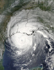
AT 1000 AM CDT...1500Z...THE CENTER OF TROPICAL DEPRESSION NINE WAS
LOCATED NEAR LATITUDE 28.1 NORTH...LONGITUDE 95.2 WEST OR ABOUT 85
MILES...140 KM...SOUTH-SOUTHWEST OF GALVESTON TEXAS AND ABOUT 135
MILES...220 KM...EAST OF CORPUS CHRISTI TEXAS.
THE DEPRESSION IS MOVING TOWARD THE NORTH NEAR 6 MPH...9 KM/HR...AND
THIS GENERAL MOTION IS EXPECTED TO CONTINUE OVER THE NEXT 24 HOURS.
ON THE FORECAST TRACK...THE CENTER OF THE DEPRESSION SHOULD BE
CROSSING THE TEXAS COAST WITHIN THE WARNING AREA TONIGHT.
MAXIMUM SUSTAINED WINDS ARE NEAR 35 MPH...55 KM/HR...WITH HIGHER
GUSTS. THE DEPRESSION IS FORECAST TO BECOME A TROPICAL STORM PRIOR
TO MAKING LANDFALL. AN AIR FORCE RESERVE UNIT RECONNAISSANCE
AIRCRAFT IS INVESTIGATING THE DEPRESSION.
ESTIMATED MINIMUM CENTRAL PRESSURE IS 1006 MB...29.71 INCHES.
...PRECAUTIONARY AND PREPAREDNESS ACTIONS...
RESIDENTS ACROSS THE EASTERN HALF OF SOUTHEAST TEXAS SHOULD
PREPARE FOR HEAVY RAINFALL AND POSSIBLE FLOODING. REMEMBER
TURN AROUND DON`T DROWN. DO NOT DRIVE YOUR VEHICLE INTO
AREAS WHERE WATER COVERS THE ROADWAY.
...STORM SURGE AND STORM TIDE...
LOCATION HIGH TIDE TIMES EXPECTED WATER MAX
MORGANS POINT...
THU 4:02 AM. 3.1 FEET.
CLEAR LAKE ENTRANCE...
WED 11:46 PM. 3.0 FEET.
EAGLE POINT...
WED 9:35 PM. 3.1 FEET.
THU 10:36 PM. 2.1 FEET.
PORT BOLIVAR...
WED 5:55 PM. 3.0 FEET.
THU 5:54 AM. 3.4 FEET.
THU 6:56 PM. 2.5 FEET.
GALVESTON CHANNEL...
WED 5:41 PM. 3.0 FEET.
THU 5:40 AM. 3.4 FEET.
THU 6:42 PM. 2.5 FEET.
GALVESTON PLEASURE PIER...
WED 4:35 PM. 3.5 FEET.
THU 4:34 AM. 4.1 FEET.
THU 5:36 PM. 3.3 FEET.
JAMAICA BEACH...
WED 8:19 PM. 3.1 FEET.
THU 8:18 AM. 3.5 FEET.
THU 9:20 PM. 2.6 FEET.
SAN LUIS PASS...
WED 5:32 PM. 1.8 FEET.
THU 5:31 AM. 2.2 FEET.
THU 6:33 PM. 2.3 FEET.
FREEPORT...
WED 4:57 PM. 3.5 FEET.
THU 4:56 AM. 3.8 FEET.
THU 5:58 PM. 3.0 FEET.
PORT O CONNOR...
WED 7:34 PM. 2.4 FEET.
THU 7:30 AM. 2.7 FEET.
THU 9:02 PM. 1.9 FEET.
NOTE: TIDE LEVELS ARE REFERENCED FROM MEAN LOWER LOW WATER
...WINDS...
WINDS ARE EXPECTED TO INCREASE TO 30 TO 45 MPH ALONG THE
IMMEDIATE COAST BETWEEN SARGENT AND HIGH ISLAND THIS EVENING.
AREAS ALONG THE GALVESTON BAY SHORELINE WILL ALSO LIKELY SEE WINDS
INCREASE TO 30 TO 45 MPH LATE THIS EVENING. GUSTS BETWEEN 40
AND 50 MPH WILL BE POSSIBLE IN SQUALLS MOVING INLAND FROM THE
GULF OF MEXICO THIS EVENING AND OVERNIGHT...ESPECIALLY ACROSS
COASTAL AREAS.
...RAINFALL...
ALONG AND EAST OF A SARGENT TO HOUSTON TO LIVINGSTON LINE
RAINFALL AMOUNTS OF 5 TO 10 INCHES ARE EXPECTED WITH ISOLATED
TOTALS OF 15 INCHES POSSIBLE IN THIS AREA THROUGH THURSDAY.
...TORNADOES...
ISOLATED TORNADOES WILL BE POSSIBLE ACROSS COASTAL AREAS
LATE THIS AFTERNOON AND OVERNIGHT. OVERNIGHT...ISOLATED
TORNADOES ARE POSSIBLE EAST OF A FREEPORT TO HOUSTON TO LIVINGSTON
LINE.
...NEXT UPDATE...
THE NEXT LOCAL STATEMENT WILL BE ISSUED AROUND 2 PM CDT.
FOR MORE TROPICAL WEATHER INFORMATION...SEE THE NATIONAL HURRICANE
CENTER WEBPAGE AT
HTTP://WWW.NHC.NOAA.GOV OR THE HOUSTON/GALVESTON
NATIONAL WEATHER SERVICE WEB PAGE AT
HTTP://WWW.SRH.NOAA.GOV/HGX.
$$