
Tropical Depression GABRIELLE:Discussions and Images
Moderator: S2k Moderators
-
wxman57

- Moderator-Pro Met

- Posts: 23177
- Age: 68
- Joined: Sat Jun 21, 2003 8:06 pm
- Location: Houston, TX (southwest)
Re: Tropical Storm GABRIELLE: Discussions and Images 8 AM pag 27
Here's a zoomed-in satellite with surface obs and the center indicated by the red "X". Center is about 30 miles offshore and coastal winds are 15-20 kts. Not an impressive wind field. Clearly, all significant winds are in that one big squalls south of the center.
0 likes


-
storms in NC

- S2K Supporter

- Posts: 2338
- Joined: Thu Jul 28, 2005 2:58 pm
- Location: Wallace,NC 40 miles NE of Wilm
- Contact:
-
HURAKAN

- Professional-Met

- Posts: 46084
- Age: 39
- Joined: Thu May 20, 2004 4:34 pm
- Location: Key West, FL
- Contact:
Re:
storms in NC wrote:It is a shame we couldn't get some rain out of this. We have some clouds and little wind now but no rain. about 10 mph. I am to far inland. about 50 miles.
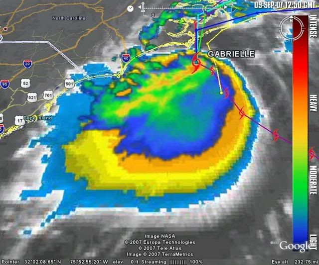
Unfortunately Gabrielle is a very small system. That has kept the convection and especially, the heavy rain, to a very small part of the storm.
0 likes

-
storms in NC
- S2K Supporter
- Posts: 2338
- Joined: Thu Jul 28, 2005 2:58 pm
- Location: Wallace,NC 40 miles NE of Wilm
- Contact:
Re: Re:
HURAKAN wrote:storms in NC wrote:It is a shame we couldn't get some rain out of this. We have some clouds and little wind now but no rain. about 10 mph. I am to far inland. about 50 miles.
Unfortunately Gabrielle is a very small system. That has kept the convection and especially, the heavy rain, to a very small part of the storm.
Just had a drop of rain but stoped.LOL
0 likes


Re:
storms in NC wrote:It is a shame we couldn't get some rain out of this. We have some clouds and little wind now but no rain. about 10 mph. I am to far inland. about 50 miles.
some rain will come for sure
0 likes
-
Tstormwatcher

- S2K Supporter
- Posts: 3086
- Joined: Thu Oct 20, 2005 7:31 pm
- Location: New Bern, NC
-
storms in NC
- S2K Supporter
- Posts: 2338
- Joined: Thu Jul 28, 2005 2:58 pm
- Location: Wallace,NC 40 miles NE of Wilm
- Contact:


Re:
Tstormwatcher wrote:This storm looks pathetic on radar.
Many 50 mph tropical storms don't look so hot.
0 likes
-
storms in NC
- S2K Supporter
- Posts: 2338
- Joined: Thu Jul 28, 2005 2:58 pm
- Location: Wallace,NC 40 miles NE of Wilm
- Contact:
Re: Re:
PhillyWX wrote:Tstormwatcher wrote:This storm looks pathetic on radar.
Many 50 mph tropical storms don't look so hot.
I think they were talking about the rain not coming to parts of ENC
0 likes
-
Tampa Bay Hurricane

- Category 5

- Posts: 5597
- Age: 38
- Joined: Fri Jul 22, 2005 7:54 pm
- Location: St. Petersburg, FL
Re: Re:
storms in NC wrote:PhillyWX wrote:Tstormwatcher wrote:This storm looks pathetic on radar.
Many 50 mph tropical storms don't look so hot.
I think they were talking about the rain not coming to parts of ENC
The convection is getting larger. I hope the
convection explodes over a larger area so you
all can get good rain well inland.
0 likes
-
wxman57
- Moderator-Pro Met
- Posts: 23177
- Age: 68
- Joined: Sat Jun 21, 2003 8:06 pm
- Location: Houston, TX (southwest)
Re: Tropical Storm GABRIELLE: Discussions and Images 8 AM pag 27
For those of you who may be unaware, the Hurricane Research Division (HRD) posts near real-time wind analyses of active TCs on their web page. Here's the page for Gabrielle:
http://www.aoml.noaa.gov/hrd/Storm_pages/gabrielle2007/wind.html
I say "near real time", and I mean they're generally under 12 hours old. Takes a bit of time to get all the data put together from the various recon planes and surface obs. Note that last night's map indicates max winds of only 30 kts. Like I had said, recon didn't find winds to support TS strength, but the NHC would and should continue Gabrielle as a TS because the center was edging toward the convection:
Last edited by wxman57 on Sun Sep 09, 2007 8:17 am, edited 1 time in total.
0 likes

-
seahawkjd
- S2K Supporter
- Posts: 632
- Joined: Wed Sep 10, 2003 4:12 pm
- Location: Morehead City, NC
- Contact:
Re: Tropical Storm GABRIELLE: Discussions and Images 8 AM pag 27
With the convection expanding quite a bit to the south, is there a chance the center will relocate again further south or is it pretty set at this point?
0 likes


-
Tampa Bay Hurricane
- Category 5
- Posts: 5597
- Age: 38
- Joined: Fri Jul 22, 2005 7:54 pm
- Location: St. Petersburg, FL
Re: Tropical Storm GABRIELLE: Discussions and Images 8 AM pag 27
Very good news for carolina- the convection has expanded
since yesterday so a lot more people will
get drought-mitigating rains from this
cute storm.
since yesterday so a lot more people will
get drought-mitigating rains from this
cute storm.
0 likes
Who is online
Users browsing this forum: No registered users and 11 guests