Hurricane FELIX: Caribbean-Discussions

Moderator: S2k Moderators

Message
Author
User avatar
HURAKAN
Professional-Met
Professional-Met
Posts: 46086
Age: 38
Joined: Thu May 20, 2004 4:34 pm
Location: Key West, FL
Contact:

#561 Postby HURAKAN » Sun Sep 02, 2007 7:26 am

Latest:
Image

I think it's time to move the floater!!!

Image

GETTING "THE LOOK"!!!
0 likes   

User avatar
crownweather
S2K Supporter
S2K Supporter
Posts: 595
Age: 50
Joined: Sat Aug 12, 2006 9:21 am
Location: Sturbridge, Massachusetts
Contact:

#562 Postby crownweather » Sun Sep 02, 2007 8:05 am

Am hoping someone may be able to help....

I'm looking for the link that contains the SHIPS intensity guidance calculations, including forecast wind shear, chance of rapid intensification, etc, etc. I've seen it posted here before, but am looking for an actual link.

Thanks
0 likes   

User avatar
HURAKAN
Professional-Met
Professional-Met
Posts: 46086
Age: 38
Joined: Thu May 20, 2004 4:34 pm
Location: Key West, FL
Contact:

#563 Postby HURAKAN » Sun Sep 02, 2007 8:14 am

Image

One picture, two concerns.
0 likes   

User avatar
Chacor
Category 5
Category 5
Posts: 10229
Joined: Mon Oct 02, 2006 10:43 pm
Location: Singapore

#564 Postby Chacor » Sun Sep 02, 2007 8:24 am

Okay, I hardly do this, but that is really a small eye.
0 likes   

User avatar
hial2
S2K Supporter
S2K Supporter
Posts: 809
Joined: Fri Oct 10, 2003 9:20 pm
Location: Indian trail N.C.

Re:

#565 Postby hial2 » Sun Sep 02, 2007 8:25 am

[quote="HURAKAN"][img]

One picture, two concerns.[/quote]

Sounds like the title of a latin soap opera... :D
0 likes   

User avatar
HURAKAN
Professional-Met
Professional-Met
Posts: 46086
Age: 38
Joined: Thu May 20, 2004 4:34 pm
Location: Key West, FL
Contact:

Re:

#566 Postby HURAKAN » Sun Sep 02, 2007 8:32 am

Chacor wrote:Okay, I hardly do this, but that is really a small eye.


Not any more.

Latest:
Image

Image
0 likes   

User avatar
jasons2k
Storm2k Executive
Storm2k Executive
Posts: 8245
Age: 51
Joined: Wed Jul 06, 2005 12:32 pm
Location: The Woodlands, TX

Re: Hurricane FELIX:Caribbean-Discussions & Imagery 8AM pag 28

#567 Postby jasons2k » Sun Sep 02, 2007 8:34 am

Latest from Jeff Lindner:

Forecast to become a major hurricane in the Caribbean Sea.

Discussion:

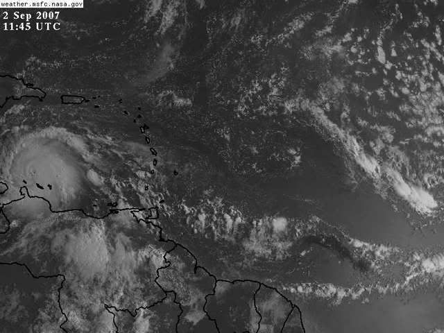
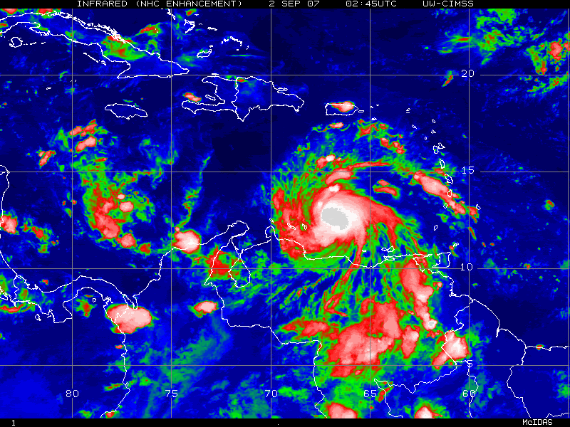
Felix has continued to develop overnight with outflow expanding and deep cold convection over the center. Radar data from the aircraft and the ABC islands shows a well defined eye and an eye should become clear in visible and IR images today. Felix has been tracking at around 275 degrees for the last several hours. Latest recon pass and dropsonde into the eyewall recorded 93kt winds and a pressure of 983mb…hence the upgrade to cat 2 with 100mph surface winds.

Track:

Global guidance has come into better agreement with the track of Felix although there remains uncertainty at days 4 and 5. Guidance is tightly clustered on a W to WNW track for the next 72-96 hours taking the hurricane toward the N coast of Honduras and then toward Belize. The GFDL and NOGAPS (right outliers yesterday) are now in agreement with the GFS, EURO, and CMC on a more southern track. In fact after being the far northern outlier yesterday the GFDL is now the most south model. The HWRF is doing a funky stall and dance over the W Caribbean and turning the system due N along the E coast of the Yucatan…this model is being completely disregarded. So a landfall in Belize looks highly likely at this time and maybe even northern Honduras. The questions begin to arise as to what is left of Felix after crossing land areas, does it re-emerge into the Bay of Campeche, and how much ridging is found N of Felix if it makes it into the BOC. The first two questions will be mainly answered by the track and at this time a further southward track suggest Felix will be over land longer. Not sure if Felix will emerge into the BOC as a hurricane as suggested by NHC as even cat 5 Dean was only around 80mph when it emerged and it was moving faster and Felix will cross more land. The third question dealing with the ridge intensity is tied to the weakness over TX and the ejection and eastward movement of a long wave trough over the Rockies. Ridging may in fact never fully establish over TX as has been common this summer, but Felix may be too far southern to feel any effects of troughing over the central US. In fact Felix may never make it over the landmasses of Central America to emerge into the BOC. Way too many question marks in the Day 4-5 frame to be certain on any final track for Felix due mainly to land interactions and time spent over those land areas.

Intensity:

Based on the good presentation on satellite images and great radar presentation Felix is well on his way to becoming a major hurricane. The intensity models make the storm a major hurricane and peak it at a cat 4. Given the warm SST’s ahead of the hurricane, high oceanic heat content, and favorable upper air outflow pattern I see no reason why Felix will not reach cat 4 intensity. In fact a cat 5 is within reason as Felix reaches the western Caribbean as long as it remains just N of coastal Honduras. IF Felix does make it into the BOC toward Friday morning it would likely be a tropical storm or at most a cat 1 hurricane. As with Dean the system would likely begin to intensify over the warm waters of the southern Gulf.
0 likes   

O Town
S2K Supporter
S2K Supporter
Posts: 5205
Age: 52
Joined: Wed Sep 07, 2005 9:37 pm
Location: Orlando, Florida 28°35'35"N 81°22'55"W

#568 Postby O Town » Sun Sep 02, 2007 8:34 am

This thing blew up last night. Really hard to see the tiny eye in some images like this one.

Image
0 likes   

User avatar
mf_dolphin
Category 5
Category 5
Posts: 17758
Age: 68
Joined: Tue Oct 08, 2002 2:05 pm
Location: St Petersburg, FL
Contact:

Re: Hurricane FELIX:Caribbean-Discussions & Imagery 8AM pag 28

#569 Postby mf_dolphin » Sun Sep 02, 2007 8:34 am

The last vortex data message showed a 25 mile eye. I think it just hasn't finished clearing out but it shouldn't be too long.
0 likes   

Javlin
Category 5
Category 5
Posts: 1620
Age: 64
Joined: Fri Jul 09, 2004 7:58 pm
Location: ms gulf coast

Re: Hurricane FELIX:Caribbean-Discussions & Imagery 8AM pag 28

#570 Postby Javlin » Sun Sep 02, 2007 8:37 am

Felix definitly looks to be heading in more of a true WNW motion for the lasts 9hrs or so.Doesn't Felix need to do this for like 12hrs to generally agreed as true change in direction?
0 likes   

User avatar
msbee
S2K Supporter
S2K Supporter
Posts: 3027
Joined: Wed Jun 11, 2003 10:11 am
Location: St. Maarten

#571 Postby msbee » Sun Sep 02, 2007 8:39 am

Latest report from Aruba on stormcarib.com:
Now We Are In It

* From: David & Heather Everon <arubayourwaytours at yahoo.com>
* Date: Sun, 2 Sep 2007 06:28:44 -0700 (PDT)

"The rain is coming down so hard now visibility is at a minimum. Wind gusts are strong and frequent. The streets are flooded and now some TV channels are out.

We were going to try to go out and take some photos but now is not the time. Hopefully later."

The hurricane correspondent from Curacao reports that storm winds never reached Curacao.
0 likes   

jhamps10

Re: Hurricane FELIX:Caribbean-Discussions & Imagery 8AM pag 28

#572 Postby jhamps10 » Sun Sep 02, 2007 8:42 am

Javlin wrote:Felix definitly looks to be heading in more of a true WNW motion for the lasts 9hrs or so.Doesn't Felix need to do this for like 12hrs to generally agreed as true change in direction?

some people use 6 hours, some 8-10 hours, and there are some that use 12 hours.

personally i'd call it a change right now, as we are getting close to 10 hours of a wnw, with some more NW wobbles, but mainly WNW. in fact it is now a bit north of due east of the next forecasted point on the satellite for 2PM (13.2/71.2)
0 likes   

HurricaneHunter914
Category 5
Category 5
Posts: 4439
Age: 31
Joined: Fri Mar 10, 2006 7:36 pm
Location: College Station, TX

#573 Postby HurricaneHunter914 » Sun Sep 02, 2007 8:52 am

http://www.ssd.noaa.gov/goes/flt/t1/loop-avn.html

DANG! Felix really blew up last night! Also, he seems to be north of the forcasted track.
0 likes   

Sanibel
Category 5
Category 5
Posts: 10375
Joined: Mon Aug 30, 2004 11:06 pm
Location: Offshore SW Florida

Re: Hurricane FELIX:Caribbean-Discussions & Imagery 8AM pag 28

#574 Postby Sanibel » Sun Sep 02, 2007 8:54 am

Fist. Go for category 3 now.

Storm is now bumping WNW and constitutes serious threat to Belize.

Can't believe what I saw when I signed on this am. 2007 climatology holding true.

Lyons said Aruba sent 6mph wind reading from station. Shows how those official readings can be bogus.
0 likes   

Javlin
Category 5
Category 5
Posts: 1620
Age: 64
Joined: Fri Jul 09, 2004 7:58 pm
Location: ms gulf coast

Re: Hurricane FELIX:Caribbean-Discussions & Imagery 8AM pag 28

#575 Postby Javlin » Sun Sep 02, 2007 9:10 am

jhamps10 wrote:
Javlin wrote:Felix definitly looks to be heading in more of a true WNW motion for the lasts 9hrs or so.Doesn't Felix need to do this for like 12hrs to generally agreed as true change in direction?

some people use 6 hours, some 8-10 hours, and there are some that use 12 hours.

personally i'd call it a change right now, as we are getting close to 10 hours of a wnw, with some more NW wobbles, but mainly WNW. in fact it is now a bit north of due east of the next forecasted point on the satellite for 2PM (13.2/71.2)


Then if we see this continue for the rest of the day "The Outlier HWRF"may be on to something just have to wait and see.
0 likes   

User avatar
El Nino
Category 1
Category 1
Posts: 454
Age: 47
Joined: Sun Oct 16, 2005 3:18 pm
Location: Lima - Miraflores (Peru)
Contact:

Re: Hurricane FELIX:Caribbean-Discussions & Imagery 8AM pag 28

#576 Postby El Nino » Sun Sep 02, 2007 9:14 am

WOW just WOW :eek: Yesterday, I went to sleep with a 75 mph cat1 hurricane and now he's approaching cat3. In just a few hours, he'll begin to enter in a zone with less landinteraction and higher HC. I think a cat5 is not out of question ! But surely a cat4 at this rate.
0 likes   

jhamps10

Re: Hurricane FELIX:Caribbean-Discussions & Imagery 8AM pag 28

#577 Postby jhamps10 » Sun Sep 02, 2007 9:17 am

El Nino wrote:WOW just WOW :eek: Yesterday, I went to sleep with a 75 mph cat1 hurricane and now he's approaching cat3. In just a few hours, he'll begin to enter in a zone with less landinteraction and higher HC. I think a cat5 is not out of question ! But surely a cat4 at this rate.


no kidding, in fact I think it already is a cat 3. or he sure looks like one to me.

also "Lyons said Aruba sent 6mph wind reading from station. Shows how those official readings can be bogus." here's another TWC blunder, they just called it Hurricane PHOENIX instead of Felix.
0 likes   

User avatar
chris_fit
Category 5
Category 5
Posts: 3222
Age: 42
Joined: Wed Sep 10, 2003 11:58 pm
Location: Tampa Bay Area, FL

Re: Hurricane FELIX:Caribbean-Discussions & Imagery 8AM pag 28

#578 Postby chris_fit » Sun Sep 02, 2007 9:22 am

Just an observation from watching the satellites, it is already north of its next 12hr forecast point.
0 likes   

User avatar
HURAKAN
Professional-Met
Professional-Met
Posts: 46086
Age: 38
Joined: Thu May 20, 2004 4:34 pm
Location: Key West, FL
Contact:

#579 Postby HURAKAN » Sun Sep 02, 2007 9:26 am

Latest: WOW
Image

Image
0 likes   

jhamps10

Re: Hurricane FELIX:Caribbean-Discussions & Imagery 8AM pag 28

#580 Postby jhamps10 » Sun Sep 02, 2007 9:28 am

Image
0 likes   


Return to “2007”

Who is online

Users browsing this forum: No registered users and 13 guests