Invest 94L,Near Windwards-Discussions
Moderator: S2k Moderators
-
cycloneye

- Admin

- Posts: 149283
- Age: 69
- Joined: Thu Oct 10, 2002 10:54 am
- Location: San Juan, Puerto Rico
Re: Invest 94L,East of Windwards-5:30 AM TWO Posted in page 34
Will the crew of recon find a Tropical Storm this afternoon?
0 likes

Re: Invest 94L,East of Windwards-5:30 AM TWO Posted at page 34
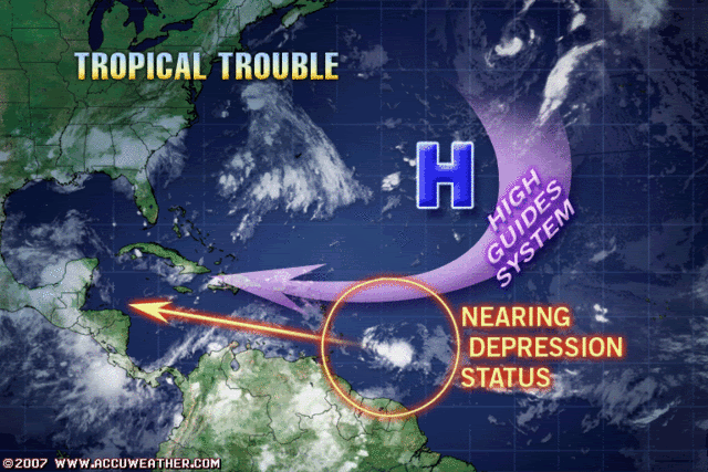
It sounds like TPC is ready to upgrade this system before the plane gets there this morning. There really isn't that much more time before it reaches the islands.
0 likes
-
caneman
Re: Invest 94L,East of Windwards-5:30 AM TWO Posted at page 34
Forgive me if this has been discussed alreay but don't have time to go thru all of the posts. It sure seems like the this is the year of due West. With this pattern of strong high pressure maybe the US will get off easy. Of course, that can change but if high pressure isn't killing of or surpressing systems it is tracking them due West which is actually funny because just a few weeks ago some here thought the troughiness pattern would never leave.. All of this can change and still think we'll have a late season so most likely will.
Last edited by caneman on Fri Aug 31, 2007 5:28 am, edited 1 time in total.
0 likes
-
alan1961

- Category 2

- Posts: 771
- Joined: Mon Mar 20, 2006 11:58 am
- Location: Derby, Derbyshire, England
- Contact:
Re: Invest 94L,East of Windwards-5:30 AM TWO Posted at page 34
does anyone think this will clear south america?..looks to be getting close to there.
0 likes
-
HURAKAN

- Professional-Met

- Posts: 46084
- Age: 39
- Joined: Thu May 20, 2004 4:34 pm
- Location: Key West, FL
- Contact:
Re: Invest 94L,East of Windwards-5:30 AM TWO Posted at page 34
alan1961 wrote:does anyone think this will clear south america?..looks to be getting close to there.
The LLC will most likely clear it, but the envelope of the storm may interact with SA.
0 likes
-
hurricanetrack

- HurricaneTrack.com

- Posts: 1781
- Joined: Tue Dec 02, 2003 10:46 pm
- Location: Wilmington, NC
- Contact:
I will be very surprised if this ever makes it to 17 degrees north latitude.
But, one has to wonder, if these southern, late bloomers continue, will one eventually form at a time when the ridge is not so strong and it could turn north in to the GOM or even later, in to the Peninsula of FL? If this is the prefered storm track this season (and it might not be- just thinking here) then eventually they will have to come more north- or maybe not. We'll see.
But, one has to wonder, if these southern, late bloomers continue, will one eventually form at a time when the ridge is not so strong and it could turn north in to the GOM or even later, in to the Peninsula of FL? If this is the prefered storm track this season (and it might not be- just thinking here) then eventually they will have to come more north- or maybe not. We'll see.
0 likes
-
caneman
Re:
hurricanetrack wrote:I will be very surprised if this ever makes it to 17 degrees north latitude.
But, one has to wonder, if these southern, late bloomers continue, will one eventually form at a time when the ridge is not so strong and it could turn north in to the GOM or even later, in to the Peninsula of FL? If this is the prefered storm track this season (and it might not be- just thinking here) then eventually they will have to come more north- or maybe not. We'll see.
Excellent point and if ends up being a late blooming season all the more likely. Question for those with excellent research skills. What year(s) thus far best matches up climitologicaly speaking with what has actually occurred thus far this year? (storm count and tracking thus far). It would be good to see as it might shed some light on what might take place in the later part of season
0 likes
-
HURAKAN
- Professional-Met
- Posts: 46084
- Age: 39
- Joined: Thu May 20, 2004 4:34 pm
- Location: Key West, FL
- Contact:
TWD 805:
TROPICAL WAVE IS ALONG 55W/56W S OF 16W MOVING W 15 KT WITH A
1010 MB LOW ALONG THE WAVE NEAR 11N. BROAD BUT LOW AMPLITUDE
LOW/MID LEVEL CYCLONIC ROTATION COVERS THE AREA FROM 9N-14N
BETWEEN 53W-59W. THIS WAVE/LOW CONTINUES TO BECOME BETTER
ORGANIZED AND COULD BECOME A TROPICAL DEPRESSION LATER TODAY.
SCATTERED MODERATE/STRONG CONVECTION IS FROM 9N-13N BETWEEN
52W-59W.
Someone is in a real hurry this morning.
0 likes
-
alan1961
- Category 2
- Posts: 771
- Joined: Mon Mar 20, 2006 11:58 am
- Location: Derby, Derbyshire, England
- Contact:
Re: Invest 94L,East of Windwards-Discussions-Analysis & Imagery
94L needs a jog NW or it could be history.
0 likes
-
Blown Away

- S2K Supporter

- Posts: 10253
- Joined: Wed May 26, 2004 6:17 am
Re: Invest 94L,East of Windwards-Discussions-Analysis & Imagery
The Bam models moved north. http://www.skeetobiteweather.com/picser ... p?t=m&m=94
0 likes
Re: Invest 94L,East of Windwards-Discussions-Analysis & Imagery
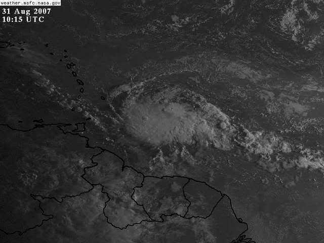
This morning's QS pass shows an elongated low presssure area. Highest winds barbs up to 35kts:
http://manati.orbit.nesdis.noaa.gov/dat ... MBas26.png
http://manati.orbit.nesdis.noaa.gov/dat ... MBas26.png
0 likes

Re: Invest 94L,East of Windwards-Discussions-Analysis & Imagery
Recon will probably find at least a TD this afternoon, development has been slow but the convection is wrapping. QS had been showing some strong winds out of the southwest so could easily be a TS before reaching the islands.
Water vapor imagery shows a large high over the plains again with the atlantic ridge building west. In between the two anticyclones is usually where the mid term shear and steering action develops.
An upper level low formed and rolled west ahead of Dean with the subtropical ridge simply following but that is not the only possible scenario for 94L.
A trough could amplify off the east coast more than the models are currently predicting. Its too early (for me) to be sure where the trough will split and how the atlantic ridge will build west.
http://wwwghcc.msfc.nasa.gov/GOES/goeseastnhewv.html
Last edited by Nimbus on Fri Aug 31, 2007 6:44 am, edited 1 time in total.
0 likes
-
jlauderdal
- S2K Supporter
- Posts: 7240
- Joined: Wed May 19, 2004 5:46 am
- Location: NE Fort Lauderdale
- Contact:
Re:
HURAKAN wrote:TWD 805:
TROPICAL WAVE IS ALONG 55W/56W S OF 16W MOVING W 15 KT WITH A
1010 MB LOW ALONG THE WAVE NEAR 11N. BROAD BUT LOW AMPLITUDE
LOW/MID LEVEL CYCLONIC ROTATION COVERS THE AREA FROM 9N-14N
BETWEEN 53W-59W. THIS WAVE/LOW CONTINUES TO BECOME BETTER
ORGANIZED AND COULD BECOME A TROPICAL DEPRESSION LATER TODAY.
SCATTERED MODERATE/STRONG CONVECTION IS FROM 9N-13N BETWEEN
52W-59W.
Someone is in a real hurry this morning.
everyone is, they are closing the office early today for the three day weekend so expect the 205 around noon.
0 likes


Re: Invest 94L,East of Windwards-Discussions-Analysis & Imagery
alan1961 wrote:94L needs a jog NW or it could be history.
Steering winds turn NW as it approaches the Leeward Islands in response to a deep trough off the east coast of FL. This will likely turn the system more W-NW or NW over the next 24-48 hrs. It is interesting that the FSUMM5 model brings the storm further northward near Hispanola and south coast of Cuba.
http://cimss.ssec.wisc.edu/tropic/real-time/atlantic/winds/wg8dlm1.html
http://moe.met.fsu.edu/cgi-bin/mm5fsu45atc2.cgi?time=2007083100&field=Sea+Level+Pressure&hour=Animation
0 likes


Re: Invest 94L,East of Windwards-Discussions-Analysis & Imagery
Zardoz wrote:Massive convection burst:
Wow! looks like Di-Max really fed 94L the steriods. i say this will develop.
0 likes
Who is online
Users browsing this forum: No registered users and 28 guests