Invest 94L,Near Windwards-Discussions
Moderator: S2k Moderators
- windstorm99
- S2K Supporter

- Posts: 1578
- Age: 48
- Joined: Sat May 26, 2007 8:10 am
- Location: Miami, Florida
- Contact:
- Weatherfreak14
- Category 5

- Posts: 1381
- Joined: Sat Sep 24, 2005 3:40 pm
- Location: Beaufort, SC
- Contact:
Re: Invest 94L in Central Atlantic-Discussions-Analysis-Imagery
WOW, this board will completly overload with that much activity... 
0 likes
- bvigal
- S2K Supporter

- Posts: 2276
- Joined: Sun Jul 24, 2005 8:49 am
- Location: British Virgin Islands
- Contact:
Re: Invest 94L in Central Atlantic-Discussions-Analysis-Imagery
windstorm99 - nice blowup. what model, what run, how many hours? (:eek: my heart skipped a couple of beats)
0 likes
- windstorm99
- S2K Supporter

- Posts: 1578
- Age: 48
- Joined: Sat May 26, 2007 8:10 am
- Location: Miami, Florida
- Contact:
Re: Invest 94L in Central Atlantic-Discussions-Analysis-Imagery
bvigal wrote:windstorm99 - nice blowup. what model, what run, how many hours? (:eek: my heart skipped a couple of beats)
Its from 12z GFS....Its likely wrong but the signal is there as we approach the peak of the season.
If it were to verify the board will probably explode.
0 likes
- ConvergenceZone
- Category 5

- Posts: 5241
- Joined: Fri Jul 29, 2005 1:40 am
- Location: Northern California
Re: Invest 94L in Central Atlantic-Discussions-Analysis-Imagery
GFDL dissipates it....
GFDL was wrong about Dean, it can be wrong about this one.
0 likes
- bvigal
- S2K Supporter

- Posts: 2276
- Joined: Sun Jul 24, 2005 8:49 am
- Location: British Virgin Islands
- Contact:
Re: Invest 94L in Central Atlantic-Discussions-Analysis-Imagery
whew! 14days out? I won't worry about that yet. Someone said the GFDL dissipates 94L in 24hrs. Isn't that model that couldn't get a grip on Dean early on? (tried to select "thinking" icon here - it not working)
*edited by southerngale to add icon for bvigal.

The code is:
*edited by southerngale to add icon for bvigal.

The code is:
Code: Select all
:think:
0 likes
- windstorm99
- S2K Supporter

- Posts: 1578
- Age: 48
- Joined: Sat May 26, 2007 8:10 am
- Location: Miami, Florida
- Contact:
Re: Invest 94L in Central Atlantic-Discussions-Analysis-Imagery
I am actually surprised to see a 12z GFDL, since the Invest came out after the 12z began running.Things could change on the next run.
0 likes
Re: Invest 94L in Central Atlantic-Discussions-Analysis-Imagery
windstorm99 wrote:
Leave it to the 384 hour GFS to give hurricane weenies what they want. In three months it'll show three or four snowstorms in the pipeline for I-95.
0 likes
-
otowntiger
- Category 5

- Posts: 1932
- Joined: Tue Aug 31, 2004 7:06 pm
Re:
HURAKAN wrote:
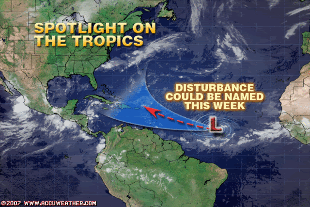
Wow. THat accuweather graphic does a good job of hyping something that's not there, and a good chance (70% according to Derek) that it won't ever be.
0 likes
Re: Re:
otowntiger wrote:HURAKAN wrote:
Wow. THat accuweather graphic does a good job of hyping something that's not there, and a good chance (70% according to Derek) that it won't ever be.
Love the cone of uncertainty...from Bermuda to Nicaragua!
0 likes
- Meso
- Category 5

- Posts: 1609
- Age: 39
- Joined: Mon Aug 09, 2004 12:14 pm
- Location: South Africa
- Contact:
TROPICAL WAVE IS ALONG 40W S OF 16W MOVING W NEAR 10 KT WITH A
1011 MB LOW ALONG THE WAVE AXIS NEAR 10N. CLUSTERS OF SCATTERED
MODERATE CONVECTION IS NOTED NEAR THE LOW CENTER FROM 9N-13N
BETWEEN 38W-44W. FURTHER N...AN AREA OF DRY AIR/ AFRICAN DUST
IS OVER THE NORTHERN END OF THE WAVE N OF 15N TO 20N.
1011 MB LOW ALONG THE WAVE AXIS NEAR 10N. CLUSTERS OF SCATTERED
MODERATE CONVECTION IS NOTED NEAR THE LOW CENTER FROM 9N-13N
BETWEEN 38W-44W. FURTHER N...AN AREA OF DRY AIR/ AFRICAN DUST
IS OVER THE NORTHERN END OF THE WAVE N OF 15N TO 20N.
0 likes
- cycloneye
- Admin

- Posts: 149275
- Age: 69
- Joined: Thu Oct 10, 2002 10:54 am
- Location: San Juan, Puerto Rico
Re: Invest 94L in Central Atlantic-Discussions-Analysis-Imagery
0 likes
- gatorcane
- S2K Supporter

- Posts: 23708
- Age: 48
- Joined: Sun Mar 13, 2005 3:54 pm
- Location: Boca Raton, FL
Re: Invest 94L in Central Atlantic-Discussions-Analysis-Imagery
that Accuweather graphic really gets me mad. They make it look like it is headed for the SE US.
As Derek says there is no evidence of that right now.
They show a 10 day cone!
As Derek says there is no evidence of that right now.
They show a 10 day cone!
0 likes
-
miamicanes177
- Category 5

- Posts: 1131
- Joined: Tue Aug 01, 2006 10:53 pm
Re: Re:
It would not be out of the question for the 6th named storm to form in an area of very low shear as we enter early September. Crazier things have happened and this becoming Felix is very plausible.otowntiger wrote:Wow. THat accuweather graphic does a good job of hyping something that's not there, and a good chance (70% according to Derek) that it won't ever be.
0 likes
- x-y-no
- Category 5

- Posts: 8359
- Age: 65
- Joined: Wed Aug 11, 2004 12:14 pm
- Location: Fort Lauderdale, FL
Re: Invest 94L in Central Atlantic-Discussions-Analysis-Imagery
gatorcane wrote:that Accuweather graphic really gets me mad. They make it look like it is headed for the SE US.
As Derek says there is no evidence of that right now.
They show a 10 day cone!
Looks like they did that track purely on climatology.
0 likes
- SouthFloridawx
- S2K Supporter

- Posts: 8346
- Age: 47
- Joined: Tue Jul 26, 2005 1:16 am
- Location: Sarasota, FL
- Contact:
Re: Invest 94L in Central Atlantic-Discussions-Analysis-Imagery
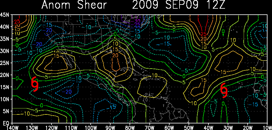
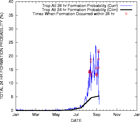
Favorable conditions ahead for this wave...
http://cimss.ssec.wisc.edu/tropic/real-time/atlantic/winds/wg8sht.html
Wind shear is well below normal for this time of year, at this point.
http://cimss.ssec.wisc.edu/tropic/real-time/atlantic/winds/wg8sht.html
Wind shear is well below normal for this time of year, at this point.


0 likes
Who is online
Users browsing this forum: No registered users and 38 guests


