About right on miss estimate
Can't stay awake. Damage reports tomorrow.
We just saw history live
'Night
CAT 5 Hurricane Dean - Archived threads
Moderator: S2k Moderators

"4:34 an CDT
I am on 4th floor... windows all boarded up , but loud whistling sound coming through. Ceiling light fixtures bobbing up and down. I think roof may have opened up or some may have come off. Loud crashing sounds indicate things hitting building. When I peek out intact windows, most trees in front of hotel are down. We are getting through it and most people are calm.
KEITH'S NOTES.... I told Josh that radar indicated eyewall of storm was passing just north of him, and he agreed that while this was the worst conditions he had ever experienced, they were not Cat 5.
Dictated by Josh via telephone; posted by his friend Keith"
Thought I'd pass along Hurricane Josh's account from Chetumal. Apparantly damage is occuring as debris is hitting the building. Southern eyewall (and worst conditions) have yet to make their closest approach to Chetumal per radar. Admits that these are the worst conditions he has ever experienced (Has chased storms like Wilma in S FL)
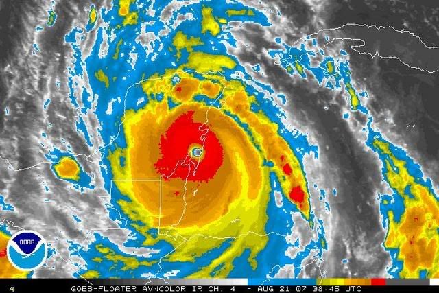
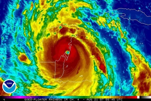
Eye still deteriorating but remains well defined despite being well inland.
I am on 4th floor... windows all boarded up , but loud whistling sound coming through. Ceiling light fixtures bobbing up and down. I think roof may have opened up or some may have come off. Loud crashing sounds indicate things hitting building. When I peek out intact windows, most trees in front of hotel are down. We are getting through it and most people are calm.
KEITH'S NOTES.... I told Josh that radar indicated eyewall of storm was passing just north of him, and he agreed that while this was the worst conditions he had ever experienced, they were not Cat 5.
Dictated by Josh via telephone; posted by his friend Keith"
Thought I'd pass along Hurricane Josh's account from Chetumal. Apparantly damage is occuring as debris is hitting the building. Southern eyewall (and worst conditions) have yet to make their closest approach to Chetumal per radar. Admits that these are the worst conditions he has ever experienced (Has chased storms like Wilma in S FL)
Eye still deteriorating but remains well defined despite being well inland.
0 likes
-
wxwatcher91

- Category 5

- Posts: 1605
- Joined: Wed Jul 06, 2005 2:43 pm
- Location: Keene, NH
- Contact:
-
wxwatcher91
- Category 5
- Posts: 1605
- Joined: Wed Jul 06, 2005 2:43 pm
- Location: Keene, NH
- Contact:
Normandy wrote:"5 am CDT
Wind continues... very violent, rapidly shifting direction - but it hasn't increased in a while - and I have a feeling it won't get worse. Streets are flooded - not sure if it's rain or maybe storm surge. Sounds are creepy and weird... special effects sounds. Not sure where we are going from here...
Dictated by Josh via telephone; posted by his friend Keith
"
"5:20 am CDT
Spoke too soon... highest winds so far - lots of trees going down - much heavier rain"
Eyewall looks to go right over Chetumal in then next hour....worse conditions yet to come.
0 likes


-
Coredesat
Re:
wxwatcher91 wrote:Did anyone by chance save an IR image of Dean between 2345z yesterday and 845z today?
http://www.nrlmry.navy.mil/tcdat/tc07/A ... .100pc.jpg
EDIT: It isn't resizing for some reason.
0 likes
-
wxwatcher91
- Category 5
- Posts: 1605
- Joined: Wed Jul 06, 2005 2:43 pm
- Location: Keene, NH
- Contact:
-
wxwatcher91
- Category 5
- Posts: 1605
- Joined: Wed Jul 06, 2005 2:43 pm
- Location: Keene, NH
- Contact:


Re: Major Hurricane DEAN: 4 AM p317: Cat 5 landfall at 3:30, dis
it is moving to the Mexico City
0 likes
-
Simone Lussardi
- Tropical Low

- Posts: 24
- Age: 50
- Joined: Sat Sep 11, 2004 12:00 am
- Location: Foshan, Guangdong, China
Re: Major Hurricane DEAN: 4 AM p317: Cat 5 landfall at 3:30, dis
Hi Guys,
It's gonna be an hell of event to be remembered... Watching in total awe as it's still managing to keep an eye almost open overland ! At the moment it's the third strongest landfalling tropical cyclone on record for the Atlantic basin. Let's see if additional observation of wind speed will come in following updates.
Bye,
Simone
0 likes
-
Starburst

- S2K Supporter

- Posts: 484
- Joined: Sun Aug 28, 2005 11:03 pm
- Location: Beeville, TX
- Contact:
Re: Major Hurricane DEAN: 4 AM p317: Cat 5 landfall at 3:30, dis
Sanibel wrote:About right on miss estimate
Can't stay awake. Damage reports tomorrow.
We just saw history live
'Night
We all absolutely did just witness history and I hope to never see anything that powerful again.
0 likes
-
cycloneye

- Admin

- Posts: 149280
- Age: 69
- Joined: Thu Oct 10, 2002 10:54 am
- Location: San Juan, Puerto Rico
Re: DEAN -Threat Area -Yucatan Peninsula-Belize-Mainland Mexico
Location: Centro, Playa del Carmen, Q. Roo, Mexico
Report: Playa del Carmen has experienced strong winds during the night
but little else. It's still pretty gusty. It is doubtful that much (if
any) damage has been caused. Still no electricity which probably means
that the electricity company believes that there is still the
possibility of danger.
http://stormcarib.com/
A message from Playa del Carmen which is well north from where the eye came ashore.
Un mensaje desde Playa del Carmen.Parece que no paso mucho alli.
0 likes
Re: Major Hurricane DEAN: 4 AM p317: Cat 5 landfall at 3:30, dis
first light in the Chetumal sky just now if you watch some tv channels .
0 likes


-
cycloneye
- Admin
- Posts: 149280
- Age: 69
- Joined: Thu Oct 10, 2002 10:54 am
- Location: San Juan, Puerto Rico
Re: Hurricane DEAN Advisories & Official Forecast Maps
WTNT34 KNHC 211145
TCPAT4
BULLETIN
HURRICANE DEAN INTERMEDIATE ADVISORY NUMBER 33A
NWS TPC/NATIONAL HURRICANE CENTER MIAMI FL AL042007
700 AM CDT TUE AUG 21 2007
...DEAN MOVING OVER THE YUCATAN PENINSULA OF MEXICO...
A HURRICANE WARNING IS IN EFFECT FOR THE ENTIRE COASTLINE OF BELIZE
AND ALONG THE EAST COAST OF THE YUCATAN PENINSULA OF MEXICO
FROM THE BELIZE/MEXICO BORDER NORTHWARD TO CANCUN. A HURRICANE
WARNING IS ALSO IN EFFECT ALONG THE WEST COAST OF THE YUCATAN
PENINSULA AND THE GULF COAST OF MEXICO FROM SOUTH OF PROGRESO
SOUTHWARD AND WESTWARD TO VERACRUZ. PREPARATIONS IN THE HURRICANE
WARNING AREA ALONG THE GULF COAST OF MEXICO SHOULD BE RUSHED TO
COMPLETION.
A HURRICANE WATCH IS IN EFFECT FOR THE GULF COAST OF MEXICO FROM
NORTH OF VERACRUZ TO TAMPICO. A HURRICANE WATCH MEANS THAT
HURRICANE CONDITIONS ARE POSSIBLE WITHIN THE WATCH AREA...GENERALLY
WITHIN 36 HOURS.
A TROPICAL STORM WARNING IS ALSO IN EFFECT ALONG THE NORTHERN COAST
OF THE YUCATAN PENINSULA FROM NORTH OF CANCUN TO PROGRESSO.
A TROPICAL STORM WATCH ALSO REMAINS IN EFFECT FOR THE FOLLOWING
PROVINCES OF CUBA...PINAR DEL RIO...LA HABANA...AND ISLA DE LA
JUVENTUD. THIS WATCH WILL LIKELY BE DISCONTINUED LATER THIS
MORNING.
INTERESTS ELSEWHERE IN THE SOUTHERN GULF OF MEXICO SHOULD CLOSELY
MONITOR THE PROGRESS OF DEAN.
FOR STORM INFORMATION SPECIFIC TO YOUR AREA...INCLUDING POSSIBLE
INLAND WATCHES AND WARNINGS...PLEASE MONITOR PRODUCTS ISSUED
BY YOUR LOCAL WEATHER OFFICE.
AT 700 AM CDT...1200Z...THE CENTER OF HURRICANE DEAN WAS LOCATED
INLAND OVER THE YUCATAN PENINSULA NEAR LATITUDE 18.9
NORTH...LONGITUDE 88.7 WEST OR ABOUT 40 MILES...60 KM...NORTHWEST
OF CHETUMAL MEXICO AND ABOUT 135 MILES...220 KM...EAST-SOUTHEAST OF
CAMPECHE MEXICO.
DEAN IS MOVING TOWARD THE WEST-NORTHWEST NEAR 20 MPH...32 KM/HR...
AND A WEST-NORTHWESTWARD TO WESTWARD MOTION IS EXPECTED TODAY AND
TONIGHT. ON THE FORECAST TRACK...THE CENTER WILL REACH THE SOUTHERN
BAY OF CAMPECHE LATE THIS AFTERNOON.
MAXIMUM SUSTAINED WINDS ARE NEAR 125 MPH...205 KM/HR...WITH HIGHER
GUSTS. DEAN IS NOW A CATEGORY THREE HURRICANE ON THE SAFFIR-SIMPSON
SCALE. ALTHOUGH CONTINUED WEAKENING IS FORECAST AS DEAN CROSSES THE
YUCATAN PENINSULA...DEAN IS EXPECTED TO STILL BE A HURRICANE WHEN
IT REACHES THE BAY OF CAMPECHE.
HURRICANE FORCE WINDS EXTEND OUTWARD UP TO 60 MILES...95 KM...FROM
THE CENTER...AND TROPICAL STORM FORCE WINDS EXTEND OUTWARD UP TO 175
MILES...280 KM.
THE ESTIMATED MINIMUM CENTRAL PRESSURE IS 935 MB...27.61 INCHES.
STORM SURGE FLOODING AND WAVES WILL GRADUALLY DIMINISH ALONG THE
EAST COAST OF THE YUCATAN PENINSULA TODAY. WITHIN THE HURRICANE
WARNING AREA IN THE BAY OF CAMPECHE...STORM SURGE FLOODING OF 6 TO
8 FEET ABOVE NORMAL TIDE LEVELS IS POSSIBLE...ALONG WITH LARGE AND
DANGEROUS BATTERING WAVES.
DEAN IS EXPECTED TO PRODUCE STORM TOTAL RAINFALL OF 5 TO 10 INCHES
OVER THE ISTHMUS OF TEHUANTEPEC AND YUCATAN PENINSULA OF MEXICO...
BELIZE...GUATEMALA...AND NORTHERN HONDURAS...WITH MAXIMUM AMOUNTS
OF UP TO 20 INCHES. THESE RAINS COULD CAUSE LIFE-THREATENING FLASH
FLOODS AND MUD SLIDES.
REPEATING THE 700 AM CDT POSITION...18.9 N...88.7 W. MOVEMENT
TOWARD...WEST-NORTHWEST NEAR 20 MPH. MAXIMUM SUSTAINED WINDS...125
MPH. MINIMUM CENTRAL PRESSURE...935 MB.
THE NEXT ADVISORY WILL BE ISSUED BY THE NATIONAL HURRICANE CENTER AT
1000 AM CDT.
$$
FORECASTER FRANKLIN/RHOME
0 likes
-
cycloneye
- Admin
- Posts: 149280
- Age: 69
- Joined: Thu Oct 10, 2002 10:54 am
- Location: San Juan, Puerto Rico
Re: Major Hurricane DEAN: 4 AM p317: Cat 5 landfall at 3:30, dis
AT 700 AM CDT...1200Z...THE CENTER OF HURRICANE DEAN WAS LOCATED
INLAND OVER THE YUCATAN PENINSULA NEAR LATITUDE 18.9
NORTH...LONGITUDE 88.7 WEST OR ABOUT 40 MILES...60 KM...NORTHWEST
OF CHETUMAL MEXICO AND ABOUT 135 MILES...220 KM...EAST-SOUTHEAST OF
CAMPECHE MEXICO.
DEAN IS MOVING TOWARD THE WEST-NORTHWEST NEAR 20 MPH...32 KM/HR...
AND A WEST-NORTHWESTWARD TO WESTWARD MOTION IS EXPECTED TODAY AND
TONIGHT. ON THE FORECAST TRACK...THE CENTER WILL REACH THE SOUTHERN
BAY OF CAMPECHE LATE THIS AFTERNOON.
MAXIMUM SUSTAINED WINDS ARE NEAR 125 MPH...205 KM/HR...WITH HIGHER
GUSTS. DEAN IS NOW A CATEGORY THREE HURRICANE ON THE SAFFIR-SIMPSON
SCALE. ALTHOUGH CONTINUED WEAKENING IS FORECAST AS DEAN CROSSES THE
YUCATAN PENINSULA...DEAN IS EXPECTED TO STILL BE A HURRICANE WHEN
IT REACHES THE BAY OF CAMPECHE.
0 likes
Who is online
Users browsing this forum: No registered users and 47 guests