CAT 5 Hurricane Dean - Archived threads

Moderator: S2k Moderators

Message
Author
kurtpage
Tropical Storm
Tropical Storm
Posts: 228
Joined: Tue Sep 20, 2005 11:16 pm
Location: Texas

Re: Major Hurricane DEAN: (11 PM page 299) Discussions, Analysis

#10841 Postby kurtpage » Mon Aug 20, 2007 11:10 pm

wow...


Image
Image


Edited to add legend...
0 likes   

User avatar
marcane_1973
Category 1
Category 1
Posts: 330
Age: 51
Joined: Mon Jun 26, 2006 11:01 pm
Location: N.C.
Contact:

Re: Major Hurricane DEAN: (11 PM page 299) Discussions, Analysis

#10842 Postby marcane_1973 » Mon Aug 20, 2007 11:11 pm

sponger wrote:Wow! Our first hurricane and it reaches a five! I wonder what the rest of this season has in store?

Hopefully all fishies because I dont think the GOM is ready for a Mean Dean. They need a break. I just have a feeling that the they way things are shaping up this could be another bad year for the Caribbean and GOM with the East coast maybe getting spared again.
0 likes   

Hockey007
Tropical Depression
Tropical Depression
Posts: 51
Joined: Mon Aug 20, 2007 11:02 pm

#10843 Postby Hockey007 » Mon Aug 20, 2007 11:12 pm

Blue is starting to show up on the water vapor imagery... this system has intensified greatly in the last 4 hours, after many were second guessing whether it would be the lowest cat 4 pressure for a hurricane too, I'm new, but is an increase in feeder band intensity also contributed to an intensifying storm?
Edit: Blue is not purple... I'm losing my sense of colors >_>
Last edited by Hockey007 on Mon Aug 20, 2007 11:18 pm, edited 1 time in total.
0 likes   

User avatar
Sean in New Orleans
Category 5
Category 5
Posts: 1794
Joined: Thu Aug 28, 2003 7:26 pm
Location: New Orleans, LA 30.0N 90.0W
Contact:

#10844 Postby Sean in New Orleans » Mon Aug 20, 2007 11:13 pm

This Rainbow image is very telling and revealing. Note the extreme intensity on the top side of the eyewall. It just revealed itself in the last hour to 90 minutes and is rapidly wrapping around the entire eye. Extremely impressive:

Image
0 likes   

Matt-hurricanewatcher

Re: Major Hurricane DEAN: (11 PM page 299) Discussions, Analysis

#10845 Postby Matt-hurricanewatcher » Mon Aug 20, 2007 11:13 pm

Starting to look like a Typhoon with those colder cloud tops.
0 likes   

mtm4319
Category 5
Category 5
Posts: 1537
Joined: Sun Sep 12, 2004 2:47 am
Location: Mobile, AL

Re: Major Hurricane DEAN: (11 PM page 299) Discussions, Analysis

#10846 Postby mtm4319 » Mon Aug 20, 2007 11:15 pm

Technically the lowest pressure for a Cat-4 was Wilma's 899 mb. Yep, that's right...

Now if Dean had peaked at 155mph, then it would have become the most intense storm never to reach Cat-5.
0 likes   

User avatar
marcane_1973
Category 1
Category 1
Posts: 330
Age: 51
Joined: Mon Jun 26, 2006 11:01 pm
Location: N.C.
Contact:

Re: Major Hurricane DEAN: (11 PM page 299) Discussions, Analysis

#10847 Postby marcane_1973 » Mon Aug 20, 2007 11:16 pm

Can you guys just imagine what kind storm surge to the right of that northern eyewall we are talking about with this monster. I sure hope everyone that was told to leave did and MOVED WELL INLAND.
0 likes   

temujin
Tropical Storm
Tropical Storm
Posts: 109
Joined: Thu Aug 25, 2005 9:58 pm

Re:

#10848 Postby temujin » Mon Aug 20, 2007 11:18 pm

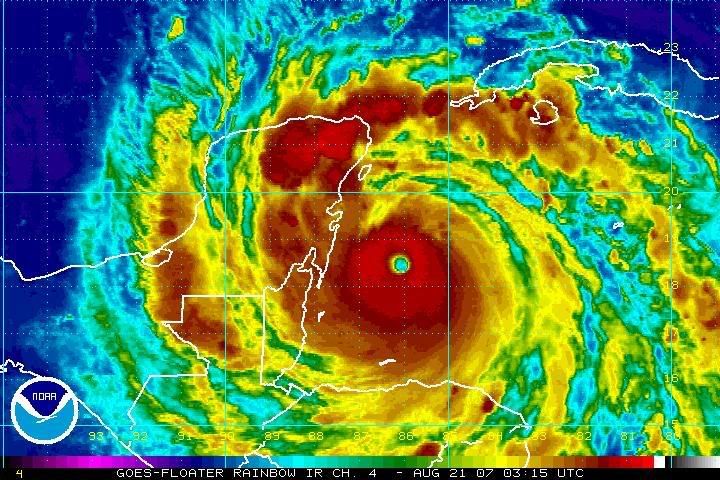
Sean in New Orleans wrote:This Rainbow image is very telling and revealing. Note the extreme intensity on the top side of the eyewall. It just revealed itself in the last hour to 90 minutes and is rapidly wrapping around the entire eye. Extremely impressive:


He's only got three or four hours left to strengthen... but he is like a sprinter coming up on the finish line...
0 likes   

User avatar
sponger
S2K Supporter
S2K Supporter
Posts: 1620
Joined: Thu Jul 22, 2004 11:26 am
Location: St Augustine

Re: Major Hurricane DEAN: (11 PM page 299) Discussions, Analysis

#10849 Postby sponger » Mon Aug 20, 2007 11:21 pm

Does anyone know the storm surge prediction? Moving fast will be good for the shorter duration winds but would it increase the storm surge? Especially at that right angle?
0 likes   

User avatar
typhoon_tim
Tropical Low
Tropical Low
Posts: 30
Age: 44
Joined: Tue Jun 13, 2006 6:29 pm
Location: Myrtle Beach, SC
Contact:

Re: Hurricane DEAN Recon obs

#10850 Postby typhoon_tim » Mon Aug 20, 2007 11:21 pm

000
URNT15 KNHC 210415
AF306 1504A DEAN HDOB 07 20070821
040500 2548N 08746W 4098 07481 0471 -140 -400 136024 024 010 000 00
040530 2545N 08746W 4100 07482 0470 -140 -398 135023 024 013 000 00
040600 2543N 08745W 4098 07479 0470 -140 -386 135026 026 007 001 00
040630 2541N 08744W 4099 07485 0470 -140 -358 136025 025 015 000 00
040700 2538N 08744W 4099 07479 0469 -140 -366 135025 026 013 000 00
040730 2536N 08743W 4098 07480 0469 -140 -274 137026 026 014 001 00
040800 2533N 08742W 4098 07477 0469 -140 -275 138026 026 017 000 00
040830 2531N 08742W 4100 07481 0468 -140 -266 137026 027 015 000 00
040900 2529N 08741W 4097 07478 0467 -140 -280 137025 026 018 000 00
040930 2526N 08740W 4100 07477 0467 -135 -302 141024 024 016 000 00
041000 2524N 08740W 4098 07476 0467 -135 -318 140023 023 018 000 00
041030 2522N 08739W 4099 07478 0468 -132 -320 144021 021 016 000 00
041100 2519N 08738W 4098 07472 0465 -136 -284 131021 022 016 000 00
041130 2517N 08737W 4099 07478 0466 -137 -261 122022 023 013 001 00
041200 2514N 08737W 4099 07473 0465 -136 -266 118022 022 011 001 00
041230 2512N 08736W 4096 07477 0465 -138 -260 120023 024 012 001 00
041300 2509N 08735W 4100 07476 0466 -139 -261 120024 024 012 001 00
041330 2507N 08735W 4099 07476 0465 -138 -256 119022 023 007 002 00
041400 2505N 08734W 4098 07478 0465 -138 -261 120021 022 008 002 00
041430 2502N 08733W 4099 07469 0464 -134 -251 118019 020 012 001 00
$$
0 likes   

User avatar
BensonTCwatcher
Category 5
Category 5
Posts: 1046
Joined: Sat Aug 28, 2004 10:11 pm
Location: Southport NC

#10851 Postby BensonTCwatcher » Mon Aug 20, 2007 11:21 pm

Sheep dip... the last frame on the IR floater is showing the grey = -80C I don't usually do this but :eek:
0 likes   

Scorpion

#10852 Postby Scorpion » Mon Aug 20, 2007 11:22 pm

Labor Day and Andrew. Both intensifying Cat 5's at landfall. Gilbert and Camille were not intensifying a landfall. Dean will be the third such storm in recorded history. Incredible.
0 likes   

Derek Ortt

#10853 Postby Derek Ortt » Mon Aug 20, 2007 11:23 pm

surge will likely be 10-12 feet of that... deep water offshore

However, 40-50 foot waves can be expected
0 likes   

Praxus
Category 1
Category 1
Posts: 473
Joined: Tue Aug 31, 2004 3:19 pm

Re: Major Hurricane DEAN: (11 PM page 299) Discussions, Analysis

#10854 Postby Praxus » Mon Aug 20, 2007 11:24 pm

Who would have thought the first hurricane of the season would be a historic storm.

Retirement is all but certain. I fear a substantial death toll in mexico.
0 likes   

Scorpion

#10855 Postby Scorpion » Mon Aug 20, 2007 11:25 pm

Oh vey... grey appearing on IR. This is going to be an absolute buzzsaw. I really hope the people chasing in Chetumal survive.
0 likes   

kurtpage
Tropical Storm
Tropical Storm
Posts: 228
Joined: Tue Sep 20, 2005 11:16 pm
Location: Texas

Re: Major Hurricane DEAN: (11 PM page 299) Discussions, Analysis

#10856 Postby kurtpage » Mon Aug 20, 2007 11:25 pm

Praxus wrote:Who would have thought the first hurricane of the season would be a historic storm.

Retirement is all but certain. I fear a substantial death toll in mexico.


what constitutes a name retirement by the NHC???
0 likes   

User avatar
Ptarmigan
Category 5
Category 5
Posts: 5313
Joined: Wed Aug 16, 2006 9:06 pm

Re: Major Hurricane DEAN: (11 PM page 299) Discussions, Analysis

#10857 Postby Ptarmigan » Mon Aug 20, 2007 11:26 pm

This is going to be a disaster for wherever gets hit by Dean. It's got to be really scary for them. I would be scared. :eek:
0 likes   

User avatar
WxGuy1
Professional-Met
Professional-Met
Posts: 538
Joined: Sat Oct 22, 2005 12:55 pm
Location: Oklahoma

Re:

#10858 Postby WxGuy1 » Mon Aug 20, 2007 11:27 pm

wxmann_91 wrote:This is most likely NOT under 905 mb. I'd say ~910. But guessing pressures is like throwing darts on a board. With skill, you can come close, but otherwise, it's just for kicks.


My best guess for central pressure is 900-905mb. I'd like to see a greater coverage of greys (colder than -75 or -80C cloud-top temps) on the color IR image to go <900mb. My forecast landfall intensity is 903mb minimum central pressure and 165-170mph maximum sustained winds (I'm leaning more towards 165mph, and likely within only about a mile or two of the eye).

Of course, it's almost just a guess to look at satellite and apply satellite trends to quantitative hurricane intensities.

I will agree with many folks that INTENSIFYING storms seem to be worse than WEAKENING storms, even if the minimum pressure and flight-level winds are the same (which means that the reduction factor may be higher -- such as 0.88-0.92 -- for intensifying storms and weaker -- such as 0.7-0.75 -- for weakening storms).
0 likes   

User avatar
typhoon_tim
Tropical Low
Tropical Low
Posts: 30
Age: 44
Joined: Tue Jun 13, 2006 6:29 pm
Location: Myrtle Beach, SC
Contact:

Re: Hurricane DEAN Recon obs

#10859 Postby typhoon_tim » Mon Aug 20, 2007 11:27 pm

000
URNT15 KNHC 210425
AF306 1504A DEAN HDOB 08 20070821
041500 2500N 08733W 4098 07476 0464 -131 -261 122020 021 012 002 00
041530 2457N 08732W 4099 07476 0467 -130 -268 126021 022 014 002 00
041600 2455N 08731W 4098 07475 0465 -131 -271 127022 023 013 002 00
041630 2452N 08730W 4098 07477 0467 -134 -271 126024 024 013 002 00
041700 2450N 08730W 4099 07480 0466 -135 -287 126026 027 015 002 00
041730 2447N 08729W 4098 07474 0467 -134 -323 129028 028 016 001 00
041800 2445N 08728W 4098 07476 0466 -134 -379 133030 030 016 002 00
041830 2443N 08728W 4099 07475 0467 -134 -410 133030 031 017 002 00
041900 2440N 08727W 4100 07473 0465 -130 -385 131030 030 014 002 00
041930 2438N 08726W 4098 07478 0465 -130 -448 130031 032 019 002 00
042000 2435N 08726W 4099 07474 0465 -130 -343 128032 032 020 002 00
042030 2433N 08725W 4099 07473 0464 -134 -282 124033 033 021 001 00
042100 2431N 08724W 4098 07481 0463 -135 -245 120034 034 021 001 00
042130 2428N 08724W 4099 07470 0462 -138 -245 119034 034 020 001 00
042200 2426N 08723W 4099 07473 0464 -137 -277 117034 035 021 001 00
042230 2424N 08722W 4099 07471 0462 -135 -361 117034 034 020 001 00
042300 2421N 08721W 4098 07469 0462 -135 -437 117032 032 022 000 00
042330 2419N 08721W 4098 07472 0462 -130 -466 118030 030 020 001 00
042400 2417N 08720W 4099 07473 0461 -130 -428 120031 031 020 002 00
042430 2414N 08718W 4098 07471 0459 -134 -370 120031 031 021 001 00
$$
0 likes   

Matt-hurricanewatcher

Re: Major Hurricane DEAN: (11 PM page 299) Discussions, Analysis

#10860 Postby Matt-hurricanewatcher » Mon Aug 20, 2007 11:27 pm

I think retiring should be only when a system kills thousand of people or causes tens of billions in damage. Otherwise it should not be retired.
0 likes   


Return to “2007”

Who is online

Users browsing this forum: No registered users and 9 guests