On this day in weather history ..
* 1787 - Tornadoes were reported in Connecticut, Rhode Island, Massachusetts, and New Hampshire. Wethersfield CT was hard hit by the tornado outbreak. (David Ludlum)
* 1946 - Saint Louis, MO, was deluged with a record 8.78 inches of rain in 24 hours. (The Weather Channel)
* 1967 - The "sundance fire" in northern Idaho was started by lightning. Winds of 50 mph carried firebrands as much as ten miles in advance to ignite new fires, and as a result, the forest fire spread twenty miles across the Selkirk Mountains in just twelve hours, burning 56,000 acres. The heat of the fire produced whirlwinds of flame with winds up to 300 mph which flung giant trees about like matchsticks. (David Ludlum)
* 1987 - Thunderstorms developing ahead of a sharp cold front produced severe weather in the Upper Midwest during the afternoon and evening hours, with Minnesota and eastern South Dakota hardest hit. A thunderstorm in west central Minnesota spawned a tornado at Eagle Lake which killed one person and injured eight others. A thunder- storm in eastern South Dakota produced softball size hail at Warner. (The National Weather Summary) (Storm Data)
* 1988 - Thirty five cities in twenty states in the north central and northeastern U.S. reported record high temperatures for the date, including Lamoni IA and Baltimore MD, where the mercury hit 105 degrees. Temperatures 100 degrees or above were reported in twenty-two states. Pierre SD was the hot spot in the nation with a high of 114 degrees. Bluefield WV reported eight straight days of record heat. (The National Weather Summary)
* 1989 - Evening thunderstorms in eastern New Mexico produced wind gusts to 66 mph at Clovis. Evening thunderstorms in West Texas produced baseball size hail around Hereford, Dimmitt, Ware and Dalhart. (The National Weather Summary) (Storm Data)
TODAY IN WEATHER HISTORY
Moderator: S2k Moderators
Forum rules

The posts in this forum are NOT official forecast and should not be used as such. They are just the opinion of the poster and may or may not be backed by sound meteorological data. They are NOT endorsed by any professional institution or STORM2K.
-
HURAKAN

- Professional-Met

- Posts: 46084
- Age: 39
- Joined: Thu May 20, 2004 4:34 pm
- Location: Key West, FL
- Contact:
Re: TODAY IN WEATHER HISTORY
On this day in weather history ..
* 1777 - The Battle of Bennington, delayed a day by rain, was fought. The rain delayed British reinforcements, and allowed the Vermont Militia to arrive in time, enabling the Americans to win a victory by defeating two enemy forces, one at a time. (David Ludlum)
* 1909 - A dry spell began in San Bernardino County of southern California that lasted until the 6th of May in 1912, a stretch of 994 days! Another dry spell, lasting 767 days, then began in October of 1912. (The Weather Channel)
* 1916 - Altapass NC was deluged with 22.22 inches of rain in 24 hours to establish a state record. (The Weather Channel)
* 1987 - Afternoon and evening thunderstorms developing along a cold front produced severe weather from Oklahoma to Wisconsin and Lower Michigan. Thunderstorms in central Illinois produced wind gusts to 80 mph at Springfield which toppled two large beer tents at the state fair injuring 58 persons. Thunderstorms also drenched Chicago IL with 2.90 inches of rain, making August 1987 their wettest month of record. (The National Weather Summary) (Storm Data)
* 1988 - Thunderstorms developing along a slow moving cold front produced severe weather from North Dakota to Lower Michigan during the day. Nine tornadoes were sighted in North Dakota, and thunderstorms also produced hail three inches in diameter at Lakota ND, and wind gusts to 83 mph at Marais MI. Thirty-seven cities in the northeastern U.S. reported record high temperatures for the date, including Rockford IL with a reading of 104 degrees. (The National Weather Summary) (Storm Data)
* 1989 - Late afternoon and evening thunderstorms in the Central High Plains Region produced golf ball size hail at La Junta CO, Intercanyon CO, and Custer SD. Afternoon thunderstorms over South Texas drenched Brownsville with 2.60 inches of rain. Fair skies allowed viewing of the late evening full lunar eclipse from the Great Lakes Region to the Northern and Central Plains Region, and across much of the western third of the country. (The National Weather Summary) (Storm Data)
0 likes
-
HURAKAN
- Professional-Met
- Posts: 46084
- Age: 39
- Joined: Thu May 20, 2004 4:34 pm
- Location: Key West, FL
- Contact:
On this day in weather history ..
1915 - A hurricane hit Galveston, TX, with wind gusts to 120 mph and a twelve foot storm surge. The storm claimed 275 lives, including forty-two on Galveston Island, with most deaths due to drowning. Of 250 homes built outside the seawall (which was constructed after the catastrophic hurricane of 1900), just ten percent were left standing. (The Weather Channel)
1969 - Camille, the second worst hurricane in U.S. history, smashed into the Mississippi coast. Winds gusted to 172 mph at Main Pass Block LA, and to 190 mph near Bay Saint Louis MS. The hurricane claimed 256 lives, and caused 1.3 billion dollars damage. Several ocean going ships were carried over seven miles inland by the hurricane. The hurricane produced winds to 200 mph, and a storm surge of 24.6 feet. Complete destruction occurred in some coastal areas near the eye of the hurricane. (David Ludlum) (The Weather Channel)

1987 - Evening thunderstorms produced severe weather in the Northern and Central Plains Region. One thunderstorm spawned a tornado near Fairbury NE, along with baseball size hail and wind gusts to 100 mph, causing severe crop damage west of town. Ten cities in the eastern U.S. reported record high temperatures for the date. Syracuse NY hit 97 degrees for the first time in twenty-two years. (The National Weather Summary) (Storm Data)
1988 - Fifty-five cities, from the Middle Mississippi Valley to the Middle Atlantic Coast Region, reported record high temperatures for the date. Beckley WV reported an all-time record high of 96 degrees, and Baltimore MD hit 104 degrees, marking their thirteenth day of the year with 100 degree heat. Chicago IL equalled a record with 46 days of 90 degree weather for the year. Thunderstorms produced severe weather from Wisconsin to New Jersey. Thunderstorms in New Jersey produced high winds which gusted to 92 mph at Wrightstown, and blew down a circus tent at Lavallette injuring fourteen persons. (The National Weather Summary) (Storm Data)
1989 - Morning thunderstorms produced three to six inch rains in Oklahoma, and the Arkalatex area of Arkansas, Texas and Louisiana. Tom OK was soaked with 5.98 inches of rain, and Foreman AR received 5.55 inches. Evening thunderstorms produced high winds in the Wasatch Front of northern Utah. Thunderstorm winds gusted to 66 mph at Salt Lake City, and flash flooding caused up to two million dollars damage to a marina on Lake Powell. (Storm Data) (The National Weather Summary)
1915 - A hurricane hit Galveston, TX, with wind gusts to 120 mph and a twelve foot storm surge. The storm claimed 275 lives, including forty-two on Galveston Island, with most deaths due to drowning. Of 250 homes built outside the seawall (which was constructed after the catastrophic hurricane of 1900), just ten percent were left standing. (The Weather Channel)
1969 - Camille, the second worst hurricane in U.S. history, smashed into the Mississippi coast. Winds gusted to 172 mph at Main Pass Block LA, and to 190 mph near Bay Saint Louis MS. The hurricane claimed 256 lives, and caused 1.3 billion dollars damage. Several ocean going ships were carried over seven miles inland by the hurricane. The hurricane produced winds to 200 mph, and a storm surge of 24.6 feet. Complete destruction occurred in some coastal areas near the eye of the hurricane. (David Ludlum) (The Weather Channel)
1987 - Evening thunderstorms produced severe weather in the Northern and Central Plains Region. One thunderstorm spawned a tornado near Fairbury NE, along with baseball size hail and wind gusts to 100 mph, causing severe crop damage west of town. Ten cities in the eastern U.S. reported record high temperatures for the date. Syracuse NY hit 97 degrees for the first time in twenty-two years. (The National Weather Summary) (Storm Data)
1988 - Fifty-five cities, from the Middle Mississippi Valley to the Middle Atlantic Coast Region, reported record high temperatures for the date. Beckley WV reported an all-time record high of 96 degrees, and Baltimore MD hit 104 degrees, marking their thirteenth day of the year with 100 degree heat. Chicago IL equalled a record with 46 days of 90 degree weather for the year. Thunderstorms produced severe weather from Wisconsin to New Jersey. Thunderstorms in New Jersey produced high winds which gusted to 92 mph at Wrightstown, and blew down a circus tent at Lavallette injuring fourteen persons. (The National Weather Summary) (Storm Data)
1989 - Morning thunderstorms produced three to six inch rains in Oklahoma, and the Arkalatex area of Arkansas, Texas and Louisiana. Tom OK was soaked with 5.98 inches of rain, and Foreman AR received 5.55 inches. Evening thunderstorms produced high winds in the Wasatch Front of northern Utah. Thunderstorm winds gusted to 66 mph at Salt Lake City, and flash flooding caused up to two million dollars damage to a marina on Lake Powell. (Storm Data) (The National Weather Summary)
0 likes
-
HURAKAN
- Professional-Met
- Posts: 46084
- Age: 39
- Joined: Thu May 20, 2004 4:34 pm
- Location: Key West, FL
- Contact:
On this day in weather history ..
1925 - During the late morning hours a severe hailstorm struck southeastern Iowa completely destroying crops along a path six to ten miles wide and 75 miles long. The hail also injured and killed poultry and livestock, and caused a total of 2.5 million dollars damage. The hailstorm flattened fields of corn to such an extent that many had to leave their farms in search of other work. It was one of the worst hailstorms of record for the nation. (The Weather Channel)
1983 - Hurricane Alicia ravaged southeastern Texas. The hurricane caused more than three billion dollars property damage, making it one of the costliest hurricanes in the history of the U.S. Just thirteen persons were killed, but 1800 others were injured. The hurricane packed winds to 130 mph as it crossed Galveston Island, and spawned twenty-two tornadoes in less than 24 hours as it made landfall. (The Weather Channel) (Storm Data)
1987 - Thirteen cities in the eastern U.S. reported record high temperatures for the date, including Orlando FL with a reading of 98 degrees, and Portland ME with a high of 94 degrees. Newark NJ reached 90 degrees for the thirty-sixth time of the year, their second highest total of record. (The National Weather Summary)
1988 - Twenty-two cities, from the Carolinas to the Upper Ohio Valley, reported record high temperatures for the date, pushing the total number of daily record highs since the first of June above the 1100 mark. Afternoon highs of 102 degrees at Greensboro NC and 105 degrees at Raleigh NC equalled all-time records. Evening thunderstorms in Montana produced wind gusts to 75 mph at Scobey. (The National Weather Summary) (Storm Data)
1989 - Thunderstorms over the Middle Atlantic Coast Region and the Upper Ohio Valley produced torrential rains in eastern Virginia during the late morning and afternoon hours. Totals ranged up to twelve inches at Yorktown. Williamsburg VA was deluged with 10.78 inches of rain between 6 AM and 10 AM, with 6.72 inches reported in just two hours. Flash flooding caused nearly twelve million dollars damage in Accomack County VA. Early evening thunderstorms in the Central High Plains Region produced walnut size hail and wind gusts to 80 mph around Casper WY. Thunderstorms produced locally heavy rains in the Yellowstone Park area, causing fifteen mudslides. (The National Weather Summary) (Storm Data)
0 likes
-
HURAKAN
- Professional-Met
- Posts: 46084
- Age: 39
- Joined: Thu May 20, 2004 4:34 pm
- Location: Key West, FL
- Contact:
On August 19 in weather history ..
* 1788 - A small but powerful hurricane inflicted great havoc upon forests along a narrow track from New Jersey to Maine. A similar storm track today would cause extreme disaster in the now populated area. (David Ludlum)
* 1969 - 'Never say die' Camille let loose a cloudburst in Virginia resulting in flash floods and landslides which killed 151 persons and cause 140 million dollars damage. Massies Hill VA received 27 inches of rain. (David Ludlum)
* 1986 - The temperature at San Antonio, TX, soared to an all-time record high of 108 degrees. (Sandra and TI Richard Sanders - 1987)
* 1987 - Thunderstorms moving out of southeastern Nebraska spread severe weather into eastern Kansas and western Missouri during the day. Thunderstorms in Nebraska produced hail three inches in diameter at Albion, and high winds which downed a large tent at Waterloo injuring a dozen persons. Thunderstorms in Kansas produced baseball size hail northwest of Topeka, and wind gusts to 80 mph at Fulton. Ten persons were injured in a thunderstorm at Princeton KS, and damage to crops in southern Franklin County KS was estimated at 3.5 million dollars. (Storm Data) (The National Weather Summary)
* 1988 - Raleigh, NC, reported a record hot temperature reading of 103 degrees. Afternoon thunderstorms in Oklahoma produced wind gusts to 75 mph in southern Pittsburgh County. Thunderstorms in Indiana produced 4.50 inches of rain at Morgantown. (Storm Data) (The National Weather Summary)
* 1989 - Early morning thunderstorms deluged southeastern Delaware with six to ten inches of rain in four to six hours, with local reports of 13 to 20 inches of rain. Twenty-six major roads were closed or damaged, and fourteen bridges were washed out. Flooding caused nearly four million dollars damage to local businesses. (Storm Data) (The National Weather Summary)
0 likes
-
HURAKAN
- Professional-Met
- Posts: 46084
- Age: 39
- Joined: Thu May 20, 2004 4:34 pm
- Location: Key West, FL
- Contact:
On August 20 in weather history ..
* 1886 - The town of Indianola, TX, was completely destroyed by a hurricane, and never rebuilt. (David Ludlum)
* 1910 - The "big blow up" of forest fires finally came to an end in Idaho. A record dry August fueled 1736 fires which burned three million acres destroying six billion board feet of timber. The fires claimed the lives of 85 persons, 78 of which were fire fighters, and consumed the entire town of Wallace. The smoke spread a third of the way around the world producing some dark days in the U.S. and Canada. The forest fires prompted federal fire protection laws. (David Ludlum)
* 1987 - Half a dozen cities in the Central Plains Region reported record high temperatures for the date, including Pueblo CO with a reading of 102 degrees, and Goodland KS with a high of 104 degrees. Hill City KS reached 106 degrees. (The National Weather Summary)
* 1988 - Sheridan, WY, reported a record hot temperature reading of 100 degrees. Evening thunderstorms produced golf ball size hail near Fortuna ND, and wind gusts to 70 mph near Webster SD. (The National Weather Summary) (Storm Data)
* 1989 - Early morning thunderstorms produced heavy rain in southeast Kansas and northeastern Oklahoma, with up to six inches reported around Tulsa OK. Some roads in the Tulsa area were closed by water 10 to 12 feet deep. Evening thunderstorms produced severe weather in northern Oklahoma and southern Kansas. Thunderstorms produced winds gusts to 75 mph in Major County OK, and hail two inches in diameter at Jennings KS. (The National Weather Summary) (Storm Data)
0 likes
-
HURAKAN
- Professional-Met
- Posts: 46084
- Age: 39
- Joined: Thu May 20, 2004 4:34 pm
- Location: Key West, FL
- Contact:
On August 21 in weather history ..
* 1883 - A tornado hit Rochester, MN, killing 31 persons and wrecking 1351 dwellings. (David Ludlum)
* 1888 - A tornado swarm occurred in Maryland and Delaware. Many waterspouts were seen over Chesapeake Bay. (Sandra and TI Richard Sanders - 1987)
* 1918 - A tornado struck Tyler, MN, killing 36 persons and destroying most of the business section of the town resulting in a million dollars damage. (David Ludlum)
* 1983 - The temperature at Fayetteville, NC, soared to 110 degrees to establish a state record. (The Weather Channel)
* 1987 - Early morning thunderstorms produced severe weather in eastern Iowa and west central Illinois. Thunderstorms produced wind gusts to 82 mph at Moline IL, and tennis ball size hail at Independence IA. Rock Island IL was drenched with 3.70 inches of rain. Total damage for the seven county area of west central Illinois was estimated at twelve million dollars. (National Weather Summary) (Storm Data)
* 1988 - Thunderstorms spawned several tornadoes in Iowa, produced wind gusts to 63 mph in the Council Bluffs area, and drenched Sioux Center IA with up to 6.61 inches of rain. (Storm Data) (The National Weather Summary)
* 1989 - Afternoon and evening thunderstorms produced severe weather from Kansas to Minnesota and North Dakota. Thunderstorms in Minnesota produced baseball size hail from Correll to north of Appleton. Thunderstorms in north central Kansas produced wind gusts higher than 100 mph at Wilson Dam. Thunderstorms around Lincoln NE produced baseball size hail and up to five inches of rain, and Boone NE was deluged with five inches of rain in an hour and a half. (The National Weather Summary) (Storm Data)
0 likes
-
HURAKAN
- Professional-Met
- Posts: 46084
- Age: 39
- Joined: Thu May 20, 2004 4:34 pm
- Location: Key West, FL
- Contact:
On August 22 in weather history ..
* 1816 - The growing season for corn was cut short as damaging frosts were reported from North Carolina to interior New England. (David Ludlum)
* 1923 - The temperature at Anchorage, AK, reached 82 degrees, a record for August for the location which was later tied on the 2nd in 1978. (The Weather Channel)
* 1987 - A cold front lowered temperatures 20 to 40 degrees across the north central U.S., and produced severe thunderstorms in Ohio and Lower Michigan. An early morning thunderstorm near Sydney MI produced high winds which spun a car around 180 degrees. (The National Weather Summary) (Storm Data)
* 1988 - Afternoon highs of 88 degrees at Astoria, OR, and 104 degrees at Medford, OR, were records for the date, and the number of daily record highs across the nation since the first of June topped the 2000 mark. (The National Weather Summary)
* 1989 - Evening thunderstorms in the central U.S. produced golf ball size hail at May City IA, and wind gusts to 66 mph at Balltown IA. Lightning struck a barn in Fayette County IA killing 750 hogs. Evening thunderstorms in Montana produced wind gusts to 70 mph at Havre. (The National Weather Summary) (Storm Data)
_____________________________________
Dean disrupted the flow a few days ago!!!
0 likes
-
HURAKAN
- Professional-Met
- Posts: 46084
- Age: 39
- Joined: Thu May 20, 2004 4:34 pm
- Location: Key West, FL
- Contact:
On this day in weather history ..
* 1906 - Thunderstorms deluged Kansas City, MO, with six inches of rain during the early morning, including nearly three inches in thirty minutes. (The Kansas City Weather Almanac)
* 1921 - Denver, CO, was drenched with 2.20 inches of rain in one hour, a record for that location. (The Weather Channel)
* 1933 - The Chesapeake-Potomac hurricane moved over Norfolk VA and Washington D.C. A tide seven feet above normal flooded businesses in Norfolk, and damage in Maryland was estimated at seventeen million dollars. (David Ludlum)
* 1970 - Dry thunderstorms ignited more than one hundred fires in the Wenatchee and Okanogan National Forests of Washington State. Hot, dry, and windy weather spread the fires, a few of which burned out of control through the end of the month. More than 100,000 acres burned. (The Weather Channel)
* 1987 - A cold front brought autumn-like weather to the Northern and Central Plains Region. Afternoon highs were in the 50s and 60s across parts of Colorado, Kansas and Nebraska that just two days earlier were in the 90s or above 100 degrees. Thunderstorms produced locally heavy rain in New Mexico, Texas, Oklahoma and Arkansas. (The National Weather Summary)
* 1988 - Thunderstorms produced hail an inch in diameter, wind gusts to 64 mph, and 2.62 inches of rain at Tucson AZ resulting in three million dollars damage. Cool weather prevailed in the northeastern U.S. Hartford CT reported a record low of 42 degrees. (The National Weather Summary) (Storm Data)
* 1989 - Thunderstorms produced heavy rain with flash flooding in West Virginia. Pickens, WV, reported 4.80 inches of rain in 24 hours. Evening thunderstorms in Mississippi deluged Alta Woods with 4.25 inches of rain in less than an hour. Thunderstorms also produced heavy rain in southeastern Kentucky, and flooding was reported along Big Creek and along Stinking Creek. The Stinking Creek volunteer fire department reported water levels 12 to 14 feet above bankfull. Fort Worth TX hit the 100 degree mark for the first time all year. Strong winds ushering cool air into northwest Utah gusted to 70 mph, raising clouds of dust in the salt flats. (The National Weather Summary) (Storm Data)
0 likes
-
Category 5

- Category 5

- Posts: 10074
- Age: 36
- Joined: Sun Feb 11, 2007 10:00 pm
- Location: New Brunswick, NJ
- Contact:
Re: TODAY IN WEATHER HISTORY
I've been busy with Dean so I haven't posted here in a while
1992: Hurricane Andrew stengthens to a Category 4 Hurricane and bears down on Florida.
2005: Tropical Depression 12 forms.
1992: Hurricane Andrew stengthens to a Category 4 Hurricane and bears down on Florida.
2005: Tropical Depression 12 forms.
0 likes
-
Category 5
- Category 5
- Posts: 10074
- Age: 36
- Joined: Sun Feb 11, 2007 10:00 pm
- Location: New Brunswick, NJ
- Contact:
Re: TODAY IN WEATHER HISTORY
1992: Hurricane Andrew slams into south Florida as a Category 5 Hurricane with 165mph winds.


0 likes
-
HURAKAN
- Professional-Met
- Posts: 46084
- Age: 39
- Joined: Thu May 20, 2004 4:34 pm
- Location: Key West, FL
- Contact:
On August 24 in weather history ..
1906 - A cloudburst deluged Guinea, VA, with more than nine inches of rain in just forty minutes. (David Ludlum)
1968 - Lightning struck the Crawford County fairgrounds in northwest Pennsylvania killing two persons and injuring 72 others. (The Weather Channel)
1987 - Autumn-like weather prevailed across the north central and northeastern U.S. Seven cities reported record low temperatures for the date, including Saint Cloud MN with a low of 37 degrees. Temperatures in Florida soared to 98 degrees at Pensacola and 99 degrees at Jacksonville. Thunderstorms produced heavy rain in the Southern High Plains Region, with 5.40 inches at Union NM, and 7.25 inches reported west of Anthony NM. (The National Weather Summary)
1988 - Thunderstorms in the Delaware Valley of eastern Pennsylvania produced wind gusts to 95 mph around Philadelphia, and gusts to 100 mph at Warminster. A tropical depression drenched the Cabo Rojo area of southwestern Puerto Rico with up to ten inches of rain. San Juan received 5.35 inches of rain. (Storm Data) (The National Weather Summary)
1989 - Late afternoon and evening thunderstorms produced severe weather in eastern Montana and western sections of the Dakotas. Thunderstorms in Montana produced wind gusts to 76 mph at Jordan, and golf ball size hail at Rock Springs, which collected three to four feet deep in ditches. Lewiston ID reported a record 1.50 inches of rain for the date, and a record rainfall total for August of 2.63 inches. (The National Weather Summary) (Storm Data)
0 likes
-
HURAKAN
- Professional-Met
- Posts: 46084
- Age: 39
- Joined: Thu May 20, 2004 4:34 pm
- Location: Key West, FL
- Contact:
On this day in weather history ..
1885 - A severe hurricane struck South Carolina causing 1.3 million dollars damage at Charleston. (David Ludlum)
1940 - New Jersey experienced its coldest August morning of record, with lows of 32 degrees at Layton and Charlotteburg. (The Weather Channel)
1987 - Morning thunderstorms produced heavy rain in eastern Nebraska and southwestern Iowa. Stanton IA reported 10.50 inches of rain. Water was reported up to the handle of automobiles west of Greenwood NE. Rainfall totals for a two day period ranged from 7 to 14 inches across southwestern Iowa. Crop damage was in the millions for both states. Subsequent flooding of streams in Iowa the last week of August caused millions of dollars damage to crops, as some streams crested ten feet above flood stage. (Storm Data)
1988 - Seven cities in California reported record high temperatures for the date, including Sacramento with an afternoon reading of 104 degrees. Thunderstorms produced locally heavy rains in Arizona. Chino Valley was drenched with 2.50 inches of rain in just thirty minutes washing out a couple of streets in town. (The National Weather Summary)
1989 - Morning thunderstorms drenched Spencer, IN, with 4.10 inches of rain in three hours causing extensive street flooding. Evening thunderstorms in eastern Kansas produced up to six inches of rain around Emporia, and four inches of rain in just forty-five minutes near Parsons, and also produced wind gusts to 70 mph at Lake Melvern. (The National Weather Summary) (Storm Data)
2005 - Hurricane Katrina makes landfall in South Florida with winds up to 80 mph.
0 likes
-
Category 5
- Category 5
- Posts: 10074
- Age: 36
- Joined: Sun Feb 11, 2007 10:00 pm
- Location: New Brunswick, NJ
- Contact:
Re: TODAY IN WEATHER HISTORY
2005: Katrina emerges into the GOM, strengthens to a Category 2, and is revealed as a possible threat to New Orleans.
0 likes
-
HURAKAN
- Professional-Met
- Posts: 46084
- Age: 39
- Joined: Thu May 20, 2004 4:34 pm
- Location: Key West, FL
- Contact:
On this day in weather history ..
1883 - Krakatoa Volcano exploded in the East Indies. The explosion was heard more than 2500 miles away, and every barograph around the world recorded the passage of the air wave, up to seven times. Giant waves, 125 feet high and traveling 300 mph, devastated everything in their path, hurling ashore coral blocks weighing up to 900 tons, and killing more than 36,000 persons. Volcanic ash was carried around the globe in thirteen days producing blue and green suns in the tropics, and then vivid red sunsets in higher latitudes. The temperature of the earth was lowered one degree for the next two years, finally recovering to normal by 1888. (David Ludlum)
1949 - A hurricane made landfall at Delray Beach. Winds reached 153 mph at the Jupiter Lighthouse before the anemometer failed. The hurricane caused 45 million dollars damage to crops, and also caught the Georgia and South Carolina coast resulting in another two million dollars damage. (David Ludlum)
1965 - Late night severe thunderstorms associated with an unusually strong late summer cold front produced 100 mph winds straight line winds in the Chicago area and northwest Indiana. In Lake County IND, high winds derailed a train near Crown Point, and left a canoe suspended among telephone lines. Two nights later the temperature at Midway Airport in Chicago dipped to 43 degrees, establishing a record for the month of August. (Storm Data) (Hugh Crowther)
1976 - A weak tornado touched down briefly in the Hockley Hills near Kiana, AK, about 29 miles north of the Arctic Circle. (The Weather Channel)
1987 - Showers and thunderstorms drenched northern Illinois during the morning and afternoon hours pushing August rainfall totals for Chicago, Moline and Peoria to new all-time highs for any month of the year. By the end of August, Chicago had received 17.10 inches of rain, which easily surpassed the previous record of 14.17 inches established in September 1961. (The National Weather Summary)
1988 - A dozen cities in Texas, Colorado and California reported record high temperatures for the date, including readings of 100 degrees at Pueblo CO, 106 degrees at Wichita Falls TX, and 109 degrees at Redding CA. Afternoon thunderstorms in Utah deluged the town of Beaver with more than an inch of rain in twenty minutes. (The National Weather Summary)
1989 - Anchorage, AK, was soaked with a steady rain, and the 24 hour total of 4.12 inches smashed their previous 24 hour precipitation total of 2.10 inches. It also pushed their rainfall total for the month past their previous record for August. (The National Weather Summary)
0 likes
-
HURAKAN
- Professional-Met
- Posts: 46084
- Age: 39
- Joined: Thu May 20, 2004 4:34 pm
- Location: Key West, FL
- Contact:
Aug. 27 has traditionally been an active day for hurricanes and
tropical storms in the U.S.
In 1813, a severe hurricane hit Charleston, S.C. Tides were measured
to be higher than 18 inches.
In 1881, 335 people died in a hurricane that hit Georgia and South
Carolina. The most damage occurred in Savannah and Charleston.
In 1893, the first of three great hurricanes that year in S.C., hit.
1,000 people drowned in Charleston due to tidal surge.
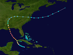
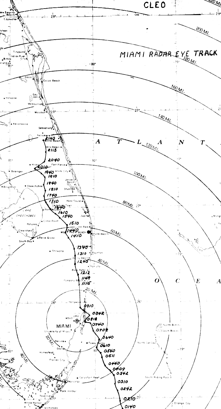
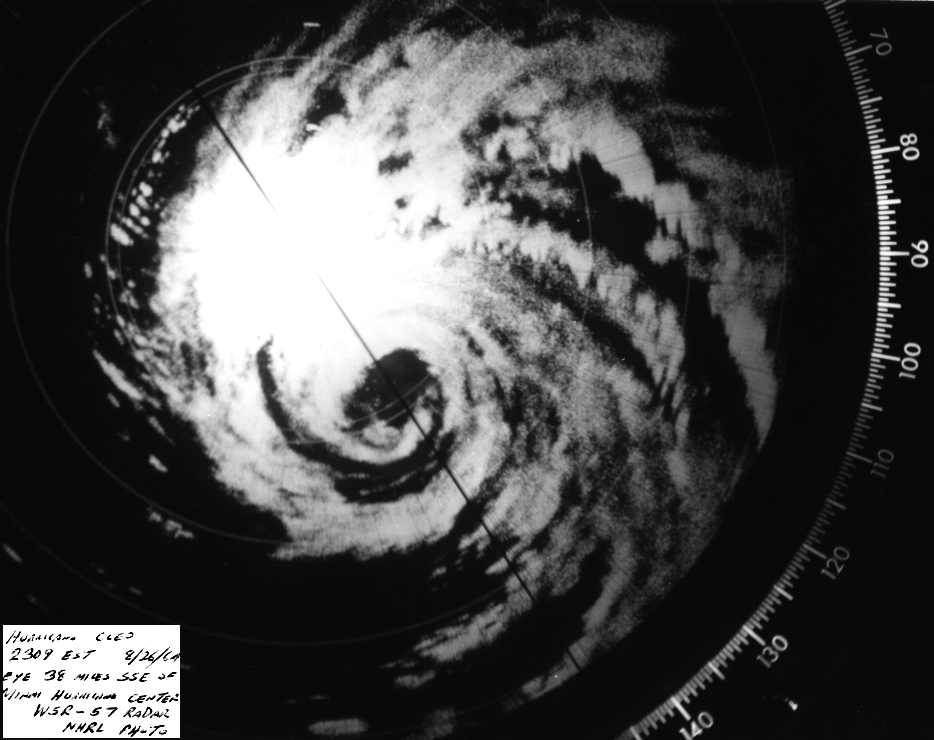
In 1964, Hurricane Cleo battered South Florida. Gusts were 135 mph and the
barometer fell to 28.57 inches. Damages topped out at $125 million.
1970 - Elko, NV, was deluged with 3.66 inches of rain in just one hour, establishing a state record. (The Weather Channel)
In 1971, Tropical Storm Doria worked up the East Coast. A tornado was
spawned in Cape May County, N.J., and 5.68 inches of rain fell in
Philadelphia, Pa.
1987 - Washington D.C. soared to a record hot 100 degrees, while clouds and rain to the north kept temperature readings in the 50s in central and southeastern New York State. (The National Weather Summary)
1988 - Afternoon thunderstorms produced locally heavy rains in the southwestern U.S. Thunderstorms in eastern New Mexico produced wind gusts to 75 mph near the White Sands Missile Range, and produced three inches of rain in two hours near the town of Belen. (National Weather Summary) (Storm Data)
1989 - Afternoon and evening thunderstorms produced severe weather in southeastern Nebraska, eastern Kansas and Missouri. Thunderstorms produced baseball size hail south of Belleville KS, and tennis ball size hail south of Lincoln NE. Thunderstorms produced golf ball size hail and wind gusts to 70 mph at Saint Joseph MO. Thunder- storms in North Dakota deluged the town of Linton with six inches of rain in one hour. (The National Weather Summary) (Storm Data)
tropical storms in the U.S.
In 1813, a severe hurricane hit Charleston, S.C. Tides were measured
to be higher than 18 inches.
In 1881, 335 people died in a hurricane that hit Georgia and South
Carolina. The most damage occurred in Savannah and Charleston.
In 1893, the first of three great hurricanes that year in S.C., hit.
1,000 people drowned in Charleston due to tidal surge.
In 1964, Hurricane Cleo battered South Florida. Gusts were 135 mph and the
barometer fell to 28.57 inches. Damages topped out at $125 million.
1970 - Elko, NV, was deluged with 3.66 inches of rain in just one hour, establishing a state record. (The Weather Channel)
In 1971, Tropical Storm Doria worked up the East Coast. A tornado was
spawned in Cape May County, N.J., and 5.68 inches of rain fell in
Philadelphia, Pa.
1987 - Washington D.C. soared to a record hot 100 degrees, while clouds and rain to the north kept temperature readings in the 50s in central and southeastern New York State. (The National Weather Summary)
1988 - Afternoon thunderstorms produced locally heavy rains in the southwestern U.S. Thunderstorms in eastern New Mexico produced wind gusts to 75 mph near the White Sands Missile Range, and produced three inches of rain in two hours near the town of Belen. (National Weather Summary) (Storm Data)
1989 - Afternoon and evening thunderstorms produced severe weather in southeastern Nebraska, eastern Kansas and Missouri. Thunderstorms produced baseball size hail south of Belleville KS, and tennis ball size hail south of Lincoln NE. Thunderstorms produced golf ball size hail and wind gusts to 70 mph at Saint Joseph MO. Thunder- storms in North Dakota deluged the town of Linton with six inches of rain in one hour. (The National Weather Summary) (Storm Data)
0 likes
-
Category 5
- Category 5
- Posts: 10074
- Age: 36
- Joined: Sun Feb 11, 2007 10:00 pm
- Location: New Brunswick, NJ
- Contact:
Re: TODAY IN WEATHER HISTORY
2005: Hurricane Katrina strengtens to a Category 3, enters EWRC.
0 likes
-
HURAKAN
- Professional-Met
- Posts: 46084
- Age: 39
- Joined: Thu May 20, 2004 4:34 pm
- Location: Key West, FL
- Contact:
On this day in weather history ..
1898 - Torrents of rain accompanied by a furious wind upset the rain gage at Fort Mohave AZ. However, water in a wash tub set out on the mesa, clear of everything, measured eight inches after the 45 minute storm. (The Weather Channel)
1911 - Saint George, GA, was deluged with 18.00 inches of rain in 24 hours to establish a state record. (The Weather Channel)
1959 - Lieutenant Colonel William Rankin bailed out of his plane at a height of 46,000 feet into a violent thunderstorm, and lived to write about the 45 minute journey (which normally would have been a thirteen minute descent). He described it as one of the most bizarre and painful experiences imaginable. (The Weather Channel)
1971 - Heavy rains from Tropical Storm Doria caused devastating floods in central and northeast New Jersey resulting in 138 million dollars damage. In southeastern Pennsylvania, high winds downed trees and power lines, and in New York City, heavy rains flooded streets and subways. (David Ludlum)
1986 - The temperature at Apalachicola, FL, dipped to 62 degrees to shatter their previous August record by four degrees, having tied their August record high of 99 degrees on the 2nd of the month. (The Weather Channel)
1987 - Severe thunderstorms broke the heat in the southeastern U.S. and the Gulf Coast Region, but not before seven cities reported record high temperatures for the date. The severe thunderstorms produced wind gusts to 80 mph downing large trees around Horse Shoe NC, and pelted southeastern Meridian MS with hail two inches in diameter. (The National Weather Summary) (Storm Data)
1988 - Tropical Storm Chris spawned a tornado near Manning, SC, which killed one person, and spawned three tornadoes in North Carolina. Chris produced one to two foot tides, and three to six inch rains, over coastal South Carolina. Severe thunderstorms in New York State and Vermont, developing ahead of a cold front, spawned a tornado which killed one person at Hector NY, produced tennis ball size hail at Brandon VT, and produced wind gusts to 80 mph at Lyndonville VT. (The National Weather Summary) (Storm Data)
1989 - Early morning thunderstorms in Nebraska produced 4.50 inches of rain around McCook, and 4.65 inches near Auburn and Brownville. Showers in Montana pushed the rainfall total for the month at Havre past the previous August record of 3.90 inches. (The National Weather Summary)
0 likes
-
Category 5
- Category 5
- Posts: 10074
- Age: 36
- Joined: Sun Feb 11, 2007 10:00 pm
- Location: New Brunswick, NJ
- Contact:
-
HURAKAN
- Professional-Met
- Posts: 46084
- Age: 39
- Joined: Thu May 20, 2004 4:34 pm
- Location: Key West, FL
- Contact:
On this day in weather history ..
1962 - Hackberry, LA, was deluged with twenty-two inches of rain in 24 hours, establishing a state record. (The Weather Channel)
1965 - A national record for the month of August was established when 2.5 inches of snow fell atop Mount Washington NH. Temperatures in New England dipped to 39 degrees at Nantucket MA, and to 25 degrees in Vermont. For many location it was the earliest freeze of record. (David Ludlum)
1987 - Some of the most powerful thunderstorms in several years developed over the piedmont of North Carolina, and marched across central sections of the state during the late afternoon and evening hours. Baseball size hail was reported around Albemarle, while thunderstorm winds downed giant trees around High Falls. (The National Weather Summary) (Storm Data)
1988 - Cool air invaded the north central U.S. Ten cities reported record low temperatures for the date, including Bismarck ND with a reading of 33 degrees. Deerfield, a small town in the Black Hills of South Dakota, reported a low of 23 degrees. The remnants of Tropical Storm Chris drenched eastern Pennsylvania with up to five and a half inches of rain, and produced high winds which gusted to 90 mph, severely damaging a hundred boats in Anne Arundel County MD. (The National Weather Summary) (Storm Data)
1989 - Evening thunderstorms produced destructive lightning in West Virginia. The lightning caused widepsread damage, particularily in Doddridge County. Numerous trees were downed closing many roads. Fire companies had a difficult time tending to the many homes and trailers on fire. Anchorage AK reported a record 9.60 inches of rain for the month of August. The average annual precipitation for Anchorage is just slighty more than fifteen inches. Three day rainfall totals in northwest Missouri ranged up to 8.20 inches at Maryville. (The National Weather Summary)
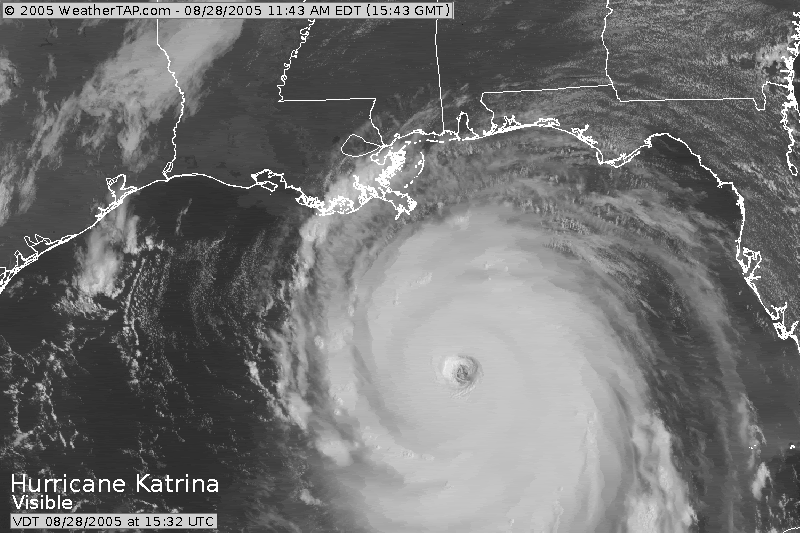
2005 - Hurricane Katrina makes landfall in southeastern Louisiana before moving into Mississippi.

1962 - Hackberry, LA, was deluged with twenty-two inches of rain in 24 hours, establishing a state record. (The Weather Channel)
1965 - A national record for the month of August was established when 2.5 inches of snow fell atop Mount Washington NH. Temperatures in New England dipped to 39 degrees at Nantucket MA, and to 25 degrees in Vermont. For many location it was the earliest freeze of record. (David Ludlum)
1987 - Some of the most powerful thunderstorms in several years developed over the piedmont of North Carolina, and marched across central sections of the state during the late afternoon and evening hours. Baseball size hail was reported around Albemarle, while thunderstorm winds downed giant trees around High Falls. (The National Weather Summary) (Storm Data)
1988 - Cool air invaded the north central U.S. Ten cities reported record low temperatures for the date, including Bismarck ND with a reading of 33 degrees. Deerfield, a small town in the Black Hills of South Dakota, reported a low of 23 degrees. The remnants of Tropical Storm Chris drenched eastern Pennsylvania with up to five and a half inches of rain, and produced high winds which gusted to 90 mph, severely damaging a hundred boats in Anne Arundel County MD. (The National Weather Summary) (Storm Data)
1989 - Evening thunderstorms produced destructive lightning in West Virginia. The lightning caused widepsread damage, particularily in Doddridge County. Numerous trees were downed closing many roads. Fire companies had a difficult time tending to the many homes and trailers on fire. Anchorage AK reported a record 9.60 inches of rain for the month of August. The average annual precipitation for Anchorage is just slighty more than fifteen inches. Three day rainfall totals in northwest Missouri ranged up to 8.20 inches at Maryville. (The National Weather Summary)
2005 - Hurricane Katrina makes landfall in southeastern Louisiana before moving into Mississippi.
0 likes
Return to “USA & Caribbean Weather”
Who is online
Users browsing this forum: No registered users and 62 guests