CAT 5 Hurricane Dean - Archived threads
Moderator: S2k Moderators

Re: T Storm Dean - Global Models=12z GFS run is being posted
Ugh, Dean is moving at nearly 20kts. Mid-level shear is relaxing, but the steering flow is still 20kts. There is no way this storm is only at 55W in 60 hours! In 60 hours this storm will already be through the Windards and in the Northeast Caribbean. This makes a huge difference on position versus the steering flow north of the Greater Antilles. I would not trust these runs beyond 50 hours right now until we have some better data or the models start initializing this system at correct forward speed!!
0 likes
-
cyclonic chronic

Re:
x-y-no wrote:Another ominous looking run for the Leewards and Puerto Rico ...
Yeah, especially by hr 72. That weak upper-level low off the southeastern US coast looks like it still may separate the Atlantic ridge and the southern US ridge enough to allow Dean to escape northwestward. I guess it matters how far south Dean can stay. If Dean stays south enough to avoid being pulled northwestward and northward by the southerly flow between the ULL and the ULH, I think it could miss that 'escape slot'. Of course, there's no way to know if that'll happen now, but the fast, WSW motion that Dean has been taking the past 24 hours isn't helping.
0 likes
-
KFDM Meteorologist

- Professional-Met

- Posts: 1314
- Joined: Tue May 16, 2006 9:52 pm
- Location: Upper Texas Coast/Orange County
-
Matt-hurricanewatcher
Re: Tropical Storm Dean (pg.28) - Discussions, Analysis and Sats
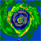
Dean is starting to look impressive, with a CDO forming right over the LLC and outflow expanding in most quads but east. I say this is close to 50 knots. This has a chance to strengthen rapidly. We will see,,,
0 likes
-
KFDM Meteorologist
- Professional-Met
- Posts: 1314
- Joined: Tue May 16, 2006 9:52 pm
- Location: Upper Texas Coast/Orange County
-
CourierPR

- Category 5

- Posts: 1336
- Age: 72
- Joined: Tue Aug 31, 2004 7:53 pm
- Location: Pompano Beach, Florida
Re: Tropical Storm Dean (pg.28) - Discussions, Analysis and Sats
Are the mountains of Puerto Rico high enough to disrupt Dean's circulation?
0 likes
Re: T Storm Dean - Global Models=12z GFS run is being posted
Big shift south!
Hurricane over Martinique in that run.
Hurricane over Martinique in that run.
Last edited by Sanibel on Tue Aug 14, 2007 11:06 am, edited 1 time in total.
0 likes
-
Ivanhater

- Storm2k Moderator

- Posts: 11221
- Age: 39
- Joined: Fri Jul 01, 2005 8:25 am
- Location: Pensacola
Re: T Storm Dean - Global Models=12z GFS run is being posted
Sanibel wrote:Big shift south!
as of now...next few hours of the run are key
0 likes

Re: Tropical Storm Dean (pg.28) - Discussions, Analysis and Sats
CourierPR wrote:Are the mountains of Puerto Rico high enough to disrupt Dean's circulation?
Mountains might be high enough, but there aren't enough of them.
0 likes
-
Wx_Warrior
- Category 5
- Posts: 2718
- Joined: Thu Aug 03, 2006 3:58 pm
- Location: Beaumont, TX
Re: T Storm Dean - Global Models=12z GFS run is being posted
Not big but one can see a little southern, per last night's run.
0 likes
-
storms in NC

- S2K Supporter

- Posts: 2338
- Joined: Thu Jul 28, 2005 2:58 pm
- Location: Wallace,NC 40 miles NE of Wilm
- Contact:
-
destruction92
- Category 1

- Posts: 312
- Joined: Sun Jul 22, 2007 10:43 pm
Re: T Storm Dean - Global Models=12z GFS run is being posted
Why is it that every few hours for the past few days we have just been posting GFS nonsense???(which can't even initialize the correct location and speed of an already DEVELOPED tropical system!)
What about other model runs...like GFDL, NOGAPS, Canadian, and Euro????
We all know how wise it is to depend on just 1 model for guidance!
Sorry for fuming, but I think it is about time we start to see some reliable data.
What about other model runs...like GFDL, NOGAPS, Canadian, and Euro????
We all know how wise it is to depend on just 1 model for guidance!
Sorry for fuming, but I think it is about time we start to see some reliable data.
Last edited by destruction92 on Tue Aug 14, 2007 11:08 am, edited 1 time in total.
0 likes


-
vacanechaser

- Category 5
- Posts: 1461
- Joined: Wed Dec 03, 2003 9:34 pm
- Location: Portsmouth, Va
- Contact:
Re: T Storm Dean - Global Models=12z GFS run is being posted
Ivanhater wrote:Sanibel wrote:Big shift south!
as of now...next few hours of the run are key
the shift could be in part due to the further south position of the center now
Jesse V. Bass III
http://www.vastormphoto.com
Hurricane Intercept Research Team
0 likes
-
x-y-no

- Category 5
- Posts: 8359
- Age: 65
- Joined: Wed Aug 11, 2004 12:14 pm
- Location: Fort Lauderdale, FL
Re: Tropical Storm Dean (pg.28) - Discussions, Analysis and Sats
RL3AO wrote:CourierPR wrote:Are the mountains of Puerto Rico high enough to disrupt Dean's circulation?
Mountains might be high enough, but there aren't enough of them.
Yeah, I think that's right.
Hispaniola can tear a storm to shreds, though.
0 likes
-
KFDM Meteorologist
- Professional-Met
- Posts: 1314
- Joined: Tue May 16, 2006 9:52 pm
- Location: Upper Texas Coast/Orange County
-
windstorm99

- S2K Supporter
- Posts: 1578
- Age: 48
- Joined: Sat May 26, 2007 8:10 am
- Location: Miami, Florida
- Contact:
Re: T Storm Dean - Global Models=12z GFS run is being posted
Not sure but looks to be getting picked up at 90hrs...
Last edited by windstorm99 on Tue Aug 14, 2007 11:08 am, edited 1 time in total.
0 likes
-
Ivanhater
- Storm2k Moderator
- Posts: 11221
- Age: 39
- Joined: Fri Jul 01, 2005 8:25 am
- Location: Pensacola
Re: T Storm Dean - Global Models=12z GFS run is being posted
vacanechaser wrote:Ivanhater wrote:Sanibel wrote:Big shift south!
as of now...next few hours of the run are key
the shift could be in part due to the further south position of the center now
Jesse V. Bass III
http://www.vastormphoto.com
Hurricane Intercept Research Team
Thats what Im thinking...already a close call for the trough picking it up..well see
0 likes
Who is online
Users browsing this forum: No registered users and 87 guests